|
| Mesoscale Discussion 816 |
|
< Previous MD Next MD >
|
|
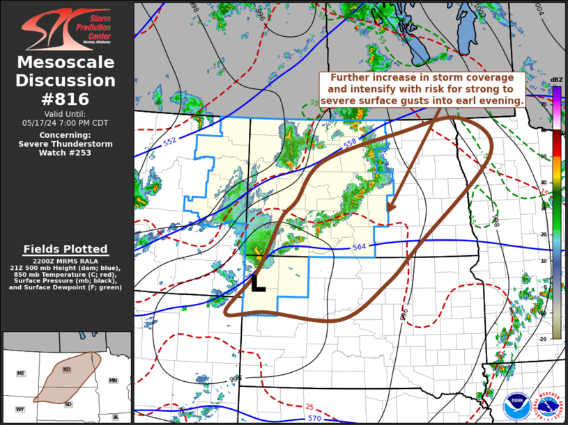
   Mesoscale Discussion 0816
   NWS Storm Prediction Center Norman OK
   0504 PM CDT Fri May 17 2024

   Areas affected...North Dakota and northwestern South Dakota

   Concerning...Severe Thunderstorm Watch 253...

   Valid 172204Z - 180000Z

   The severe weather threat for Severe Thunderstorm Watch 253
   continues.

   SUMMARY...Risk for strong to severe surface gusts will become more
   prominent with increasing thunderstorm development overspreading
   much of North Dakota through northwestern South Dakota into early
   evening.  One or two additional severe weather watches may be
   needed.

   DISCUSSION...The leading edge of stronger mid/upper support for
   upward vertical motion associated with a vigorous short wave trough
   turning eastward into the northern U.S. Rockies appears to just now
   be approaching the Montana/western Dakotas state border vicinity.
   This may be contributing to the evolving cluster of storms now
   spreading northeastward out of southeastern Montana into
   southwestern North Dakota, which may continue to intensify as it
   acquires inflow of somewhat better boundary-layer instability,
   northeast and east of a developing surface low near the western
   North and South Dakota state border area.  While it seems probable
   that this convection might gradually become the primary focus for
   strong to severe surface gusts into the evening hours, high-based
   convective development has increased and evolved into a developing
   line ahead of it, now approaching the Devils Lake vicinity.
   Embedded within moderate deep-layer west-southwesterly mean flow on
   the order of 30 kt, evaporative cooling and downward momentum
   transfer within a warm and deeply mixed boundary layer into eastern
   North Dakota may also contribute to increasing potential for locally
   strong to severe surface gusts.

   ..Kerr/Smith.. 05/17/2024

   ...Please see www.spc.noaa.gov for graphic product...

   ATTN...WFO...FGF...ABR...BIS...UNR...BYZ...

   LAT...LON   49019704 48189604 46179852 45369948 44540099 44670332
               44630459 45590361 46770291 47180243 48070160 48719903
               49019704
|
|
Top/All Mesoscale Discussions/Forecast Products/Home
|
|


 @NWSSPC