|
| Mesoscale Discussion 1623 |
|
< Previous MD Next MD >
|
|
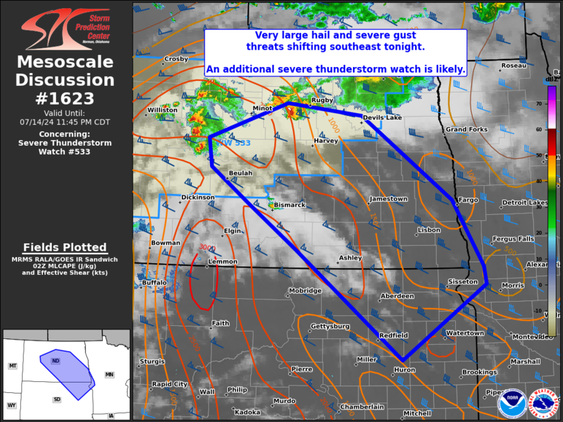
   Mesoscale Discussion 1623
   NWS Storm Prediction Center Norman OK
   0950 PM CDT Sun Jul 14 2024

   Areas affected...central to southeast ND and northeast SD

   Concerning...Severe Thunderstorm Watch 533...

   Valid 150250Z - 150445Z

   The severe weather threat for Severe Thunderstorm Watch 533
   continues.

   SUMMARY...The threat for significant large hail and severe gusts
   will likely spread southeastward from northwest/north-central North
   Dakota towards south-central/southeast North Dakota into northeast
   South Dakota overnight. An additional severe thunderstorm watch is
   likely downstream of WW 533 by 04-05Z.

   DISCUSSION...Supercell clusters in north-central and northwest North
   Dakota appear likely to consolidate over the central portion of the
   state during the next couple hours. The more intense supercell
   structures have contained MRMS MESH signatures in excess of 2 inches
   in diameter, mainly with the eastern cluster as these cells track
   steadily southeast along the composite outflow/front. The western
   cluster has accelerated eastward and should eventually merge with
   the eastern one, north-northeast of Bismarck. Despite robust MLCIN
   with southern extent, convection will likely evolve along the MLCAPE
   gradient across eastern ND into northeast SD. This will be aided by
   a slowly strengthening low-level jet, recently to around 30 kts per
   the BIS VWP. The strong deep-layer shear evident in the VWP and 00Z
   BIS sounding will likely maintain supercell structures embedded
   within the consolidating clusters. As such, a mix of both severe
   hail and wind are likely, either of which may be significant.

   ..Grams/Gleason.. 07/15/2024

   ...Please see www.spc.noaa.gov for graphic product...

   ATTN...WFO...MPX...FGF...FSD...ABR...BIS...

   LAT...LON   48390046 48209884 46949690 45959624 45699619 44569799
               46220027 46880127 47420212 47860218 48390046
|
|
Top/All Mesoscale Discussions/Forecast Products/Home
|
|


 @NWSSPC