|
| Mesoscale Discussion 1604 |
|
< Previous MD Next MD >
|
|
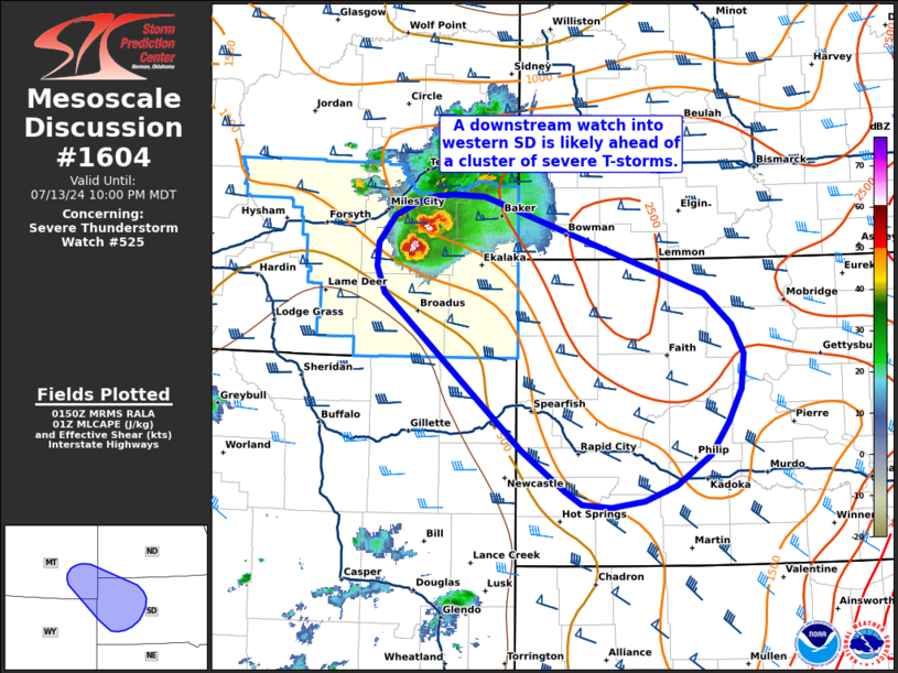
   Mesoscale Discussion 1604
   NWS Storm Prediction Center Norman OK
   0853 PM CDT Sat Jul 13 2024

   Areas affected...Southeast Montana into western South Dakota

   Concerning...Severe Thunderstorm Watch 525...

   Valid 140153Z - 140400Z

   The severe weather threat for Severe Thunderstorm Watch 525
   continues.

   SUMMARY...Downstream watch issuance into western South Dakota will
   likely be needed in near future as a cluster of severe thunderstorms
   continues to organize across southeast Montana.

   DISCUSSION...Regional radar imagery continues to show a pair of
   semi-discrete supercells migrating across southeastern MT. This
   cluster has recently produced wind damage in Miles City, MT,
   including a 72 mph measured wind gust. Velocity data from KGGW and
   KBLX continue to show well pronounced mid-level mesocyclones, but
   gradual upscale growth remains anticipated as these cells approach
   the western Dakotas. Storm track trends over the past 30 minutes
   show this cluster beginning to track more southeasterly as it
   encounters a buoyancy gradient draped from southeast MT into
   west-central SD. Continued propagation along this gradient appears
   likely with a gradual increase in severe wind potential still
   anticipated. Storm track timing estimates based on the recently
   observed motion, as well as HRRR timing forecasts, suggest this
   cluster should reach the SD border between 03-04 UTC, so downstream
   watch issuance into SD will likely be needed prior to that time.

   ..Moore.. 07/14/2024

   ...Please see www.spc.noaa.gov for graphic product...

   ATTN...WFO...ABR...BIS...UNR...BYZ...GGW...

   LAT...LON   45610585 45860597 46090595 46350573 46460544 46540517
               46560492 46540450 45600151 45310115 45020099 44690102
               44370121 44050144 43770191 43610233 43550279 43590317
               43710341 44110398 45610585
|
|
Top/All Mesoscale Discussions/Forecast Products/Home
|
|


 @NWSSPC