 Note:
The expiration time in the watch graphic is amended if the watch is
replaced, cancelled or extended.
Note:
Note:
The expiration time in the watch graphic is amended if the watch is
replaced, cancelled or extended.
Note: Click for
Watch Status Reports.
SEL1
URGENT - IMMEDIATE BROADCAST REQUESTED
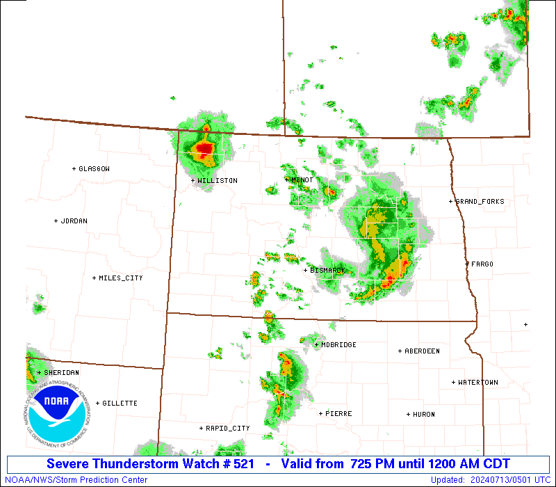
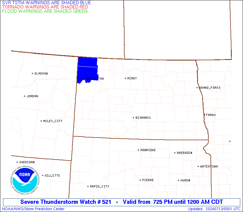
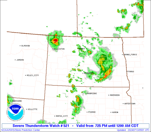
Severe Thunderstorm Watch Number 521
NWS Storm Prediction Center Norman OK
725 PM CDT Fri Jul 12 2024
The NWS Storm Prediction Center has issued a
* Severe Thunderstorm Watch for portions of
Western and Central North Dakota
* Effective this Friday night from 725 PM until Midnight CDT.
* Primary threats include...
Scattered large hail and isolated very large hail events to 2
inches in diameter possible
Isolated damaging wind gusts to 70 mph possible
SUMMARY...Thunderstorms will continue to pose a threat for large
hail generally 1-1.75 inches in diameter, and severe/damaging winds
around 60-70 mph as they move east-southeastward this evening.
The severe thunderstorm watch area is approximately along and 55
statute miles east and west of a line from 25 miles northeast of
Minot ND to 60 miles south southwest of Bismarck ND. For a complete
depiction of the watch see the associated watch outline update
(WOUS64 KWNS WOU1).
PRECAUTIONARY/PREPAREDNESS ACTIONS...
REMEMBER...A Severe Thunderstorm Watch means conditions are
favorable for severe thunderstorms in and close to the watch area.
Persons in these areas should be on the lookout for threatening
weather conditions and listen for later statements and possible
warnings. Severe thunderstorms can and occasionally do produce
tornadoes.
&&
AVIATION...A few severe thunderstorms with hail surface and aloft to
2 inches. Extreme turbulence and surface wind gusts to 60 knots. A
few cumulonimbi with maximum tops to 500. Mean storm motion vector
29025.
...Gleason

   SEL1

   URGENT - IMMEDIATE BROADCAST REQUESTED
   Severe Thunderstorm Watch Number 521
   NWS Storm Prediction Center Norman OK
   725 PM CDT Fri Jul 12 2024

   The NWS Storm Prediction Center has issued a

   * Severe Thunderstorm Watch for portions of
     Western and Central North Dakota

   * Effective this Friday night from 725 PM until Midnight CDT.

   * Primary threats include...
     Scattered large hail and isolated very large hail events to 2
       inches in diameter possible
     Isolated damaging wind gusts to 70 mph possible

   SUMMARY...Thunderstorms will continue to pose a threat for large
   hail generally 1-1.75 inches in diameter, and severe/damaging winds
   around 60-70 mph as they move east-southeastward this evening.

   The severe thunderstorm watch area is approximately along and 55
   statute miles east and west of a line from 25 miles northeast of
   Minot ND to 60 miles south southwest of Bismarck ND. For a complete
   depiction of the watch see the associated watch outline update
   (WOUS64 KWNS WOU1).

   PRECAUTIONARY/PREPAREDNESS ACTIONS...

   REMEMBER...A Severe Thunderstorm Watch means conditions are
   favorable for severe thunderstorms in and close to the watch area.
   Persons in these areas should be on the lookout for threatening
   weather conditions and listen for later statements and possible
   warnings. Severe thunderstorms can and occasionally do produce
   tornadoes.

   &&

   AVIATION...A few severe thunderstorms with hail surface and aloft to
   2 inches. Extreme turbulence and surface wind gusts to 60 knots. A
   few cumulonimbi with maximum tops to 500. Mean storm motion vector
   29025.

   ...Gleason
 Note:
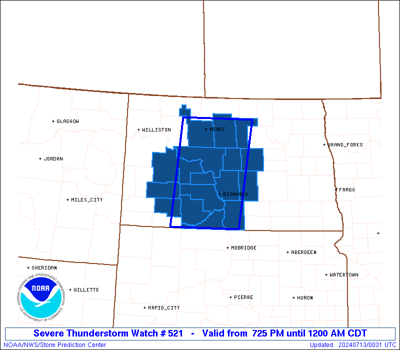
The Aviation Watch (SAW) product is an approximation to the watch area.
The actual watch is depicted by the shaded areas.
Note:
The Aviation Watch (SAW) product is an approximation to the watch area.
The actual watch is depicted by the shaded areas.
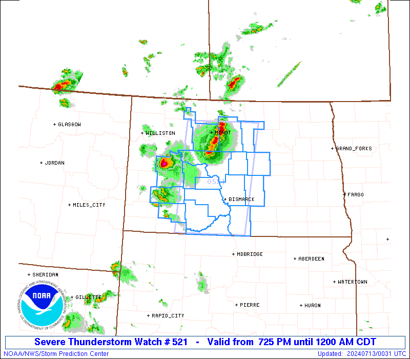
   SAW1
   WW 521 SEVERE TSTM ND 130025Z - 130500Z
   AXIS..55 STATUTE MILES EAST AND WEST OF LINE..
   25NE MOT/MINOT ND/ - 60SSW BIS/BISMARCK ND/
   ..AVIATION COORDS.. 50NM E/W /22NE MOT - 53SSW BIS/
   HAIL SURFACE AND ALOFT..2 INCHES. WIND GUSTS..60 KNOTS.
   MAX TOPS TO 500. MEAN STORM MOTION VECTOR 29025.

   LAT...LON 48529969 45970008 45970237 48520210

   THIS IS AN APPROXIMATION TO THE WATCH AREA.  FOR A
   COMPLETE DEPICTION OF THE WATCH SEE WOUS64 KWNS
   FOR WOU1.
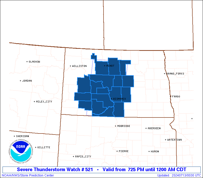
Watch 521 Status Report Messages:
STATUS REPORT #2 ON WW 521
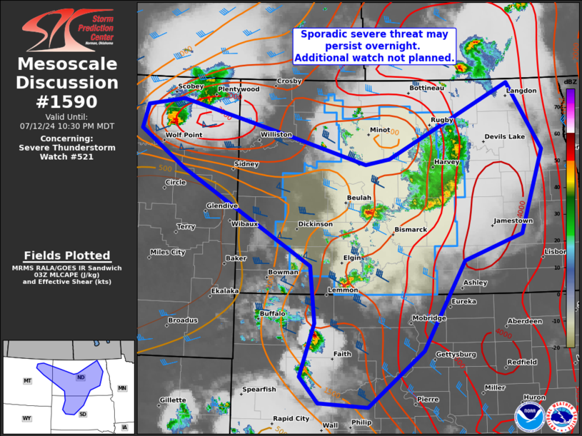
VALID 130330Z - 130440Z
SEVERE WEATHER THREAT CONTINUES RIGHT OF A LINE FROM 10 SW Y22 TO
45 SSW N60 TO 15 SSW MOT TO 65 N MOT.
FOR ADDITIONAL INFORMATION SEE MESOSCALE DISCUSSION 1590
..MOORE..07/13/24
ATTN...WFO...BIS...
&&
STATUS REPORT FOR WS 521
SEVERE WEATHER THREAT CONTINUES FOR THE FOLLOWING AREAS
NDC015-029-037-043-059-065-069-083-085-103-130440-
ND
. NORTH DAKOTA COUNTIES INCLUDED ARE
BURLEIGH EMMONS GRANT
KIDDER MORTON OLIVER
PIERCE SHERIDAN SIOUX
WELLS
$$
THE WATCH STATUS MESSAGE IS FOR GUIDANCE PURPOSES ONLY. PLEASE
REFER TO WATCH COUNTY NOTIFICATION STATEMENTS FOR OFFICIAL
INFORMATION ON COUNTIES...INDEPENDENT CITIES AND MARINE ZONES
CLEARED FROM SEVERE THUNDERSTORM AND TORNADO WATCHES.
$$
STATUS REPORT #1 ON WW 521
VALID 130225Z - 130340Z
SEVERE WEATHER THREAT CONTINUES RIGHT OF A LINE FROM 25 WNW Y22
TO 55 W MOT TO 35 N MOT.
FOR ADDITIONAL INFORMATION SEE MESOSCALE DISCUSSION 1589
..MOORE..07/13/24
ATTN...WFO...BIS...
&&
STATUS REPORT FOR WS 521
SEVERE WEATHER THREAT CONTINUES FOR THE FOLLOWING AREAS
NDC015-029-037-041-043-049-055-057-059-065-069-083-085-101-103-
130340-
ND
. NORTH DAKOTA COUNTIES INCLUDED ARE
BURLEIGH EMMONS GRANT
HETTINGER KIDDER MCHENRY
MCLEAN MERCER MORTON
OLIVER PIERCE SHERIDAN
SIOUX WARD WELLS
$$
THE WATCH STATUS MESSAGE IS FOR GUIDANCE PURPOSES ONLY. PLEASE
REFER TO WATCH COUNTY NOTIFICATION STATEMENTS FOR OFFICIAL
INFORMATION ON COUNTIES...INDEPENDENT CITIES AND MARINE ZONES
CLEARED FROM SEVERE THUNDERSTORM AND TORNADO WATCHES.
$$
Note:
Click for Complete Product Text.
Tornadoes
Probability of 2 or more tornadoes
|
Low (10%)
|
Probability of 1 or more strong (EF2-EF5) tornadoes
|
Low (<2%)
|
Wind
Probability of 10 or more severe wind events
|
Mod (30%)
|
Probability of 1 or more wind events > 65 knots
|
Low (20%)
|
Hail
Probability of 10 or more severe hail events
|
Mod (40%)
|
Probability of 1 or more hailstones > 2 inches
|
Mod (30%)
|
Combined Severe Hail/Wind
Probability of 6 or more combined severe hail/wind events
|
Mod (60%)
|
For each watch, probabilities for particular events inside the watch
(listed above in each table) are determined by the issuing forecaster.
The "Low" category contains probability values ranging from less than 2%
to 20% (EF2-EF5 tornadoes), less than 5% to 20% (all other probabilities),
"Moderate" from 30% to 60%, and "High" from 70% to greater than 95%.
High values are bolded and lighter in color to provide awareness of
an increased threat for a particular event.


 @NWSSPC