|
| Mesoscale Discussion 1590 |
|
< Previous MD Next MD >
|
|
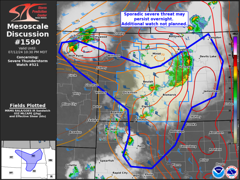
   Mesoscale Discussion 1590
   NWS Storm Prediction Center Norman OK
   1006 PM CDT Fri Jul 12 2024

   Areas affected...ND...far northeast MT...and north-central SD

   Concerning...Severe Thunderstorm Watch 521...

   Valid 130306Z - 130430Z

   The severe weather threat for Severe Thunderstorm Watch 521
   continues.

   SUMMARY...A sporadic severe hail and strong gust threat may persist
   into the overnight hours, mainly focused from far northeast Montana
   across parts of North Dakota into north-central South Dakota. An
   additional watch is not planned through 05Z.

   DISCUSSION...Several areas of thunderstorms are ongoing from far
   northeast MT across parts of ND into western SD. The primary storms
   of concern for severe in the next hour will be with two widely
   spaced discrete supercells, one to the northwest of Bismarck and the
   other east of Glasgow, both of which are along merged outflow
   boundaries. The northeast MT supercell will likely weaken as it
   encounters increasing MLCIN from both nocturnal boundary-layer
   cooling and prior overturning in western to central ND. The
   south-central ND to north-central SD corridor should be the more
   favored short-term region for severe within the pronounced MLCAPE
   gradient and lingering outflow west of a weakening cluster in
   east-central ND. A modest increase in low-level southerlies has been
   noted in area VWPs over the eastern Dakotas. Given this displacement
   to the east of the favored central Dakotas corridor, confidence is
   low in how long the severe threat may persist overnight as MLCIN
   further increases.

   ..Grams.. 07/13/2024

   ...Please see www.spc.noaa.gov for graphic product...

   ATTN...WFO...FGF...ABR...BIS...UNR...GGW...

   LAT...LON   48949834 47989762 46799808 46419929 45120014 44320129
               44380232 44750270 45530240 46340250 47710519 48260609
               48600598 48690523 48430397 48170287 47800135 47880085
               48949834
|
|
Top/All Mesoscale Discussions/Forecast Products/Home
|
|


 @NWSSPC