|
| Mesoscale Discussion 1567 |
|
< Previous MD Next MD >
|
|
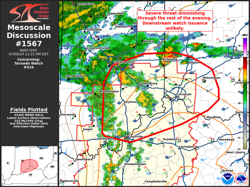
   Mesoscale Discussion 1567
   NWS Storm Prediction Center Norman OK
   0842 PM CDT Tue Jul 09 2024

   Areas affected...southeastern Indiana...northern
   Kentucky...southwestern Ohio

   Concerning...Tornado Watch 516...

   Valid 100142Z - 100315Z

   The severe weather threat for Tornado Watch 516 continues.

   SUMMARY...Severe threat continues within WW516. Severe threat will
   likely diminish into the evening.

   DISCUSSION...Activity across southeastern Indiana, northern
   Kentucky, and southwestern Ohio has trended downward in intensity
   with loss of stronger daytime heating. A few supercells have
   continued in the immediate vicinity of the warm front across
   southwestern Ohio/far southeastern Indiana. While risk for an
   occasional rotating supercell may continue into the rest of the
   evening given continued warm advection regime and strong deep layer
   shear, the overall tornado threat continues to trend slowly downward
   due to weaker instability, especially with eastern extent into OH.
   While a local extension of WW561 past 04z is possible to cover any
   lingering threat across southern Ohio, a downstream watch is not
   likely to be needed at this time.

   ..Thornton/Gleason.. 07/10/2024

   ...Please see www.spc.noaa.gov for graphic product...

   ATTN...WFO...ILN...LMK...IND...

   LAT...LON   39388639 39748616 39988535 40008457 39928410 39658356
               39258339 39038340 38838367 38548436 38178568 38298635
               38378641 39388639
|
|
Top/All Mesoscale Discussions/Forecast Products/Home
|
|


 @NWSSPC