 Note:
The expiration time in the watch graphic is amended if the watch is
replaced, cancelled or extended.
Note:
Note:
The expiration time in the watch graphic is amended if the watch is
replaced, cancelled or extended.
Note: Click for
Watch Status Reports.
SEL9
URGENT - IMMEDIATE BROADCAST REQUESTED
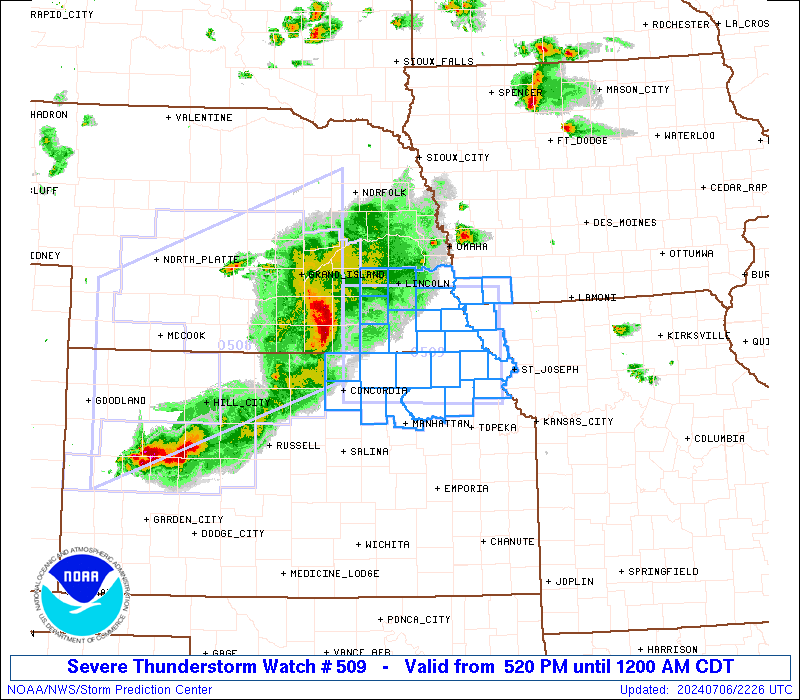
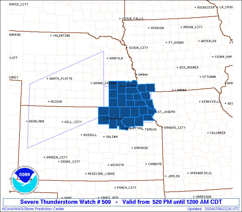
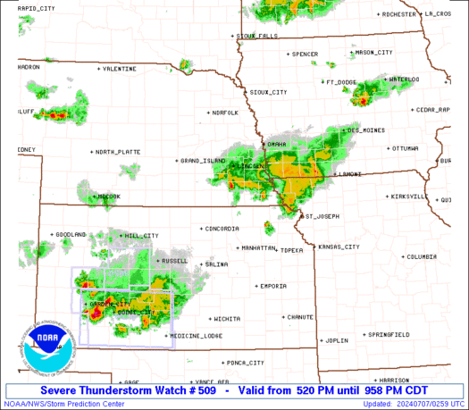
Severe Thunderstorm Watch Number 509
NWS Storm Prediction Center Norman OK
520 PM CDT Sat Jul 6 2024
The NWS Storm Prediction Center has issued a
* Severe Thunderstorm Watch for portions of
Southwest Iowa
Northeast Kansas
Northwest Missouri
Southeast Nebraska
* Effective this Saturday afternoon from 520 PM until Midnight
CDT.
* Primary threats include...
Scattered damaging winds and isolated significant gusts to 75
mph possible
Scattered large hail and isolated very large hail events to 2
inches in diameter possible
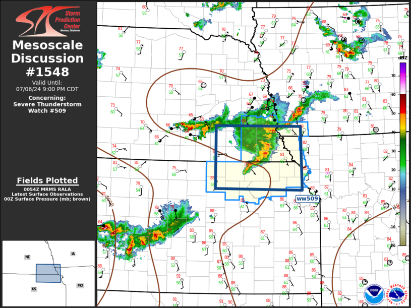
SUMMARY...A cluster of intense thunderstorms over south-central
Nebraska will track eastward through the evening across the watch
area. Locally damaging wind gusts and hail are possible with the
strongest cells.
The severe thunderstorm watch area is approximately along and 50
statute miles north and south of a line from 40 miles north of
Concordia KS to 25 miles east of Falls City NE. For a complete
depiction of the watch see the associated watch outline update
(WOUS64 KWNS WOU9).
PRECAUTIONARY/PREPAREDNESS ACTIONS...
REMEMBER...A Severe Thunderstorm Watch means conditions are
favorable for severe thunderstorms in and close to the watch area.
Persons in these areas should be on the lookout for threatening
weather conditions and listen for later statements and possible
warnings. Severe thunderstorms can and occasionally do produce
tornadoes.
&&
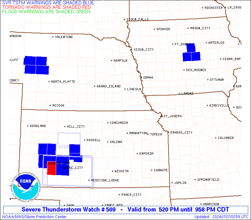
OTHER WATCH INFORMATION...CONTINUE...WW 508...
AVIATION...A few severe thunderstorms with hail surface and aloft to
2 inches. Extreme turbulence and surface wind gusts to 65 knots. A
few cumulonimbi with maximum tops to 500. Mean storm motion vector
27025.
...Hart
 Note:
The Aviation Watch (SAW) product is an approximation to the watch area.
The actual watch is depicted by the shaded areas.
Note:
The Aviation Watch (SAW) product is an approximation to the watch area.
The actual watch is depicted by the shaded areas.
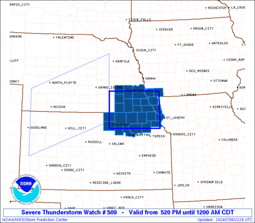
   SAW9
   WW 509 SEVERE TSTM IA KS MO NE 062220Z - 070500Z
   AXIS..50 STATUTE MILES NORTH AND SOUTH OF LINE..
   40N CNK/CONCORDIA KS/ - 25E FNB/FALLS CITY NE/
   ..AVIATION COORDS.. 45NM N/S /66W PWE - 50NNW MCI/
   HAIL SURFACE AND ALOFT..2 INCHES. WIND GUSTS..65 KNOTS.
   MAX TOPS TO 500. MEAN STORM MOTION VECTOR 27025.

   LAT...LON 40849765 40799513 39349513 39409765

   THIS IS AN APPROXIMATION TO THE WATCH AREA.  FOR A
   COMPLETE DEPICTION OF THE WATCH SEE WOUS64 KWNS
   FOR WOU9.
Watch 509 Status Report Messages:
STATUS REPORT #1 ON WW 509

VALID 070040Z - 070140Z

SEVERE WEATHER THREAT CONTINUES RIGHT OF A LINE FROM 25 NNE SLN
TO 10 N BIE TO 10 ESE OMA.

..MOORE..07/07/24

ATTN...WFO...OAX...EAX...TOP...

&&

STATUS REPORT FOR WS 509

SEVERE WEATHER THREAT CONTINUES FOR THE FOLLOWING AREAS

IAC071-145-070140-

IA
.    IOWA COUNTIES INCLUDED ARE

FREMONT 	     PAGE
$$


KSC005-013-027-043-085-117-131-149-161-201-070140-

KS
.    KANSAS COUNTIES INCLUDED ARE

ATCHISON	     BROWN		 CLAY
DONIPHAN	     JACKSON		 MARSHALL
NEMAHA		     POTTAWATOMIE	 RILEY
WASHINGTON
$$


MOC005-087-070140-

MO
.    MISSOURI COUNTIES INCLUDED ARE

ATCHISON	     HOLT
$$


NEC067-097-127-131-133-147-070140-

NE
.    NEBRASKA COUNTIES INCLUDED ARE

GAGE		     JOHNSON		 NEMAHA
OTOE		     PAWNEE		 RICHARDSON
$$


THE WATCH STATUS MESSAGE IS FOR GUIDANCE PURPOSES ONLY.  PLEASE
REFER TO WATCH COUNTY NOTIFICATION STATEMENTS FOR OFFICIAL
INFORMATION ON COUNTIES...INDEPENDENT CITIES AND MARINE ZONES
CLEARED FROM SEVERE THUNDERSTORM AND TORNADO WATCHES.
$$


 @NWSSPC