Note:
The expiration time in the watch graphic is amended if the watch is
replaced, cancelled or extended.
Note:
Note:
The expiration time in the watch graphic is amended if the watch is
replaced, cancelled or extended.
Note: Click for
Watch Status Reports.
SEL8
URGENT - IMMEDIATE BROADCAST REQUESTED
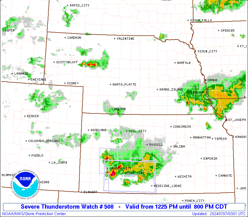
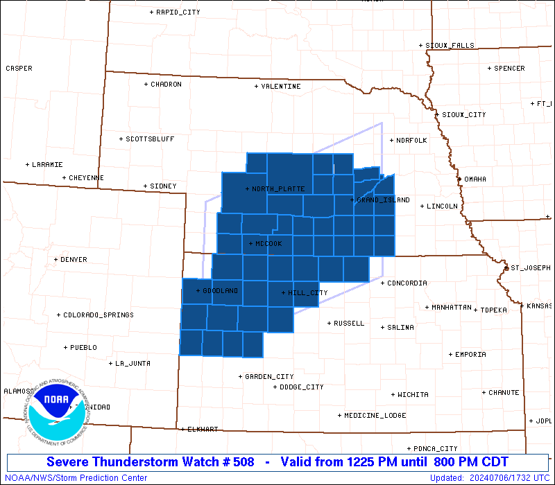
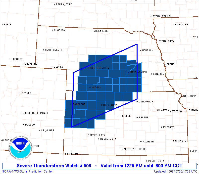
Severe Thunderstorm Watch Number 508
NWS Storm Prediction Center Norman OK
1225 PM CDT Sat Jul 6 2024
The NWS Storm Prediction Center has issued a
* Severe Thunderstorm Watch for portions of
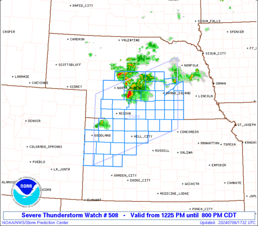
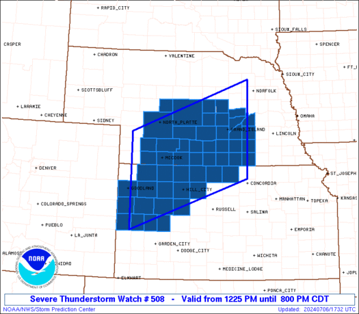
Western and Northern Kansas
Central and Southern Nebraska
* Effective this Saturday afternoon and evening from 1225 PM
until 800 PM CDT.
* Primary threats include...
Scattered damaging wind gusts to 70 mph likely
Scattered large hail and isolated very large hail events to 2.5
inches in diameter possible
A tornado or two possible
SUMMARY...Clusters of storms will continue to develop and intensify,
initially near/north of the Interstate 80 corridor in Nebraska early
this afternoon, but also across northwest Kansas. Storms should
become more scattered/widespread by late afternoon, especially
across south-central Nebraska, where large hail and damaging wind
potential may be most focused.
The severe thunderstorm watch area is approximately along and 90
statute miles north and south of a line from 65 miles south of
Imperial NE to 35 miles east of Grand Island NE. For a complete
depiction of the watch see the associated watch outline update
(WOUS64 KWNS WOU8).
PRECAUTIONARY/PREPAREDNESS ACTIONS...
REMEMBER...A Severe Thunderstorm Watch means conditions are
favorable for severe thunderstorms in and close to the watch area.
Persons in these areas should be on the lookout for threatening
weather conditions and listen for later statements and possible
warnings. Severe thunderstorms can and occasionally do produce
tornadoes.
&&
AVIATION...A few severe thunderstorms with hail surface and aloft to
2.5 inches. Extreme turbulence and surface wind gusts to 60 knots. A
few cumulonimbi with maximum tops to 550. Mean storm motion vector
29030.
...Guyer
   SEL8

   URGENT - IMMEDIATE BROADCAST REQUESTED
   Severe Thunderstorm Watch Number 508
   NWS Storm Prediction Center Norman OK
   1225 PM CDT Sat Jul 6 2024

   The NWS Storm Prediction Center has issued a

   * Severe Thunderstorm Watch for portions of
     Western and Northern Kansas
     Central and Southern Nebraska

   * Effective this Saturday afternoon and evening from 1225 PM
     until 800 PM CDT.

   * Primary threats include...
     Scattered damaging wind gusts to 70 mph likely
     Scattered large hail and isolated very large hail events to 2.5
       inches in diameter possible
     A tornado or two possible

   SUMMARY...Clusters of storms will continue to develop and intensify,
   initially near/north of the Interstate 80 corridor in Nebraska early
   this afternoon, but also across northwest Kansas. Storms should
   become more scattered/widespread by late afternoon, especially
   across south-central Nebraska, where large hail and damaging wind
   potential may be most focused.

   The severe thunderstorm watch area is approximately along and 90
   statute miles north and south of a line from 65 miles south of
   Imperial NE to 35 miles east of Grand Island NE. For a complete
   depiction of the watch see the associated watch outline update
   (WOUS64 KWNS WOU8).

   PRECAUTIONARY/PREPAREDNESS ACTIONS...

   REMEMBER...A Severe Thunderstorm Watch means conditions are
   favorable for severe thunderstorms in and close to the watch area.
   Persons in these areas should be on the lookout for threatening
   weather conditions and listen for later statements and possible
   warnings. Severe thunderstorms can and occasionally do produce
   tornadoes.

   &&

   AVIATION...A few severe thunderstorms with hail surface and aloft to
   2.5 inches. Extreme turbulence and surface wind gusts to 60 knots. A
   few cumulonimbi with maximum tops to 550. Mean storm motion vector
   29030.

   ...Guyer
 Note:
The Aviation Watch (SAW) product is an approximation to the watch area.
The actual watch is depicted by the shaded areas.
Note:
The Aviation Watch (SAW) product is an approximation to the watch area.
The actual watch is depicted by the shaded areas.
   SAW8
   WW 508 SEVERE TSTM KS NE 061725Z - 070100Z
   AXIS..90 STATUTE MILES NORTH AND SOUTH OF LINE..
   65S IML/IMPERIAL NE/ - 35E GRI/GRAND ISLAND NE/
   ..AVIATION COORDS.. 80NM N/S /12NNE GLD - 40SE OBH/
   HAIL SURFACE AND ALOFT..2.5 INCHES. WIND GUSTS..60 KNOTS.
   MAX TOPS TO 550. MEAN STORM MOTION VECTOR 29030.

   LAT...LON 40880162 42279765 39669765 38280162

   THIS IS AN APPROXIMATION TO THE WATCH AREA.  FOR A
   COMPLETE DEPICTION OF THE WATCH SEE WOUS64 KWNS
   FOR WOU8.
Watch 508 Status Report Messages:
STATUS REPORT #5 ON WW 508

VALID 062245Z - 062340Z

SEVERE WEATHER THREAT CONTINUES RIGHT OF A LINE FROM 40 SSE ITR
TO 55 SW HLC TO 35 NNW RSL TO 45 W CNK TO 35 SSW HSI TO 25 SSW
EAR TO 35 S BBW TO 35 SSE ONL.

..MOORE..07/06/24

ATTN...WFO...GLD...GID...DDC...LBF...

&&

STATUS REPORT FOR WS 508

SEVERE WEATHER THREAT CONTINUES FOR THE FOLLOWING AREAS

KSC051-063-071-089-101-123-135-141-163-165-171-195-203-062340-

KS
.    KANSAS COUNTIES INCLUDED ARE

ELLIS		     GOVE		 GREELEY
JEWELL		     LANE		 MITCHELL
NESS		     OSBORNE		 ROOKS
RUSH		     SCOTT		 TREGO
WICHITA
$$


NEC001-019-035-059-077-079-081-093-099-121-125-129-143-163-169-
181-185-062340-

NE
.    NEBRASKA COUNTIES INCLUDED ARE

ADAMS		     BUFFALO		 CLAY
FILLMORE	     GREELEY		 HALL
HAMILTON	     HOWARD		 KEARNEY
MERRICK 	     NANCE		 NUCKOLLS
POLK		     SHERMAN		 THAYER
WEBSTER 	     YORK
$$


THE WATCH STATUS MESSAGE IS FOR GUIDANCE PURPOSES ONLY.  PLEASE
REFER TO WATCH COUNTY NOTIFICATION STATEMENTS FOR OFFICIAL
INFORMATION ON COUNTIES...INDEPENDENT CITIES AND MARINE ZONES
CLEARED FROM SEVERE THUNDERSTORM AND TORNADO WATCHES.
$$

STATUS REPORT #4 ON WW 508

VALID 062140Z - 062240Z

SEVERE WEATHER THREAT CONTINUES RIGHT OF A LINE FROM 20 SSE ITR
TO 40 ESE GLD TO 35 SE MCK TO 35 WNW BUB.

FOR ADDITIONAL INFORMATION SEE MESOSCALE DISCUSSION 1544

..MOORE..07/06/24

ATTN...WFO...GLD...GID...DDC...LBF...

&&

STATUS REPORT FOR WS 508

SEVERE WEATHER THREAT CONTINUES FOR THE FOLLOWING AREAS

KSC051-063-065-071-089-101-109-123-135-137-141-147-163-165-171-
179-183-195-199-203-062240-

KS
.    KANSAS COUNTIES INCLUDED ARE

ELLIS		     GOVE		 GRAHAM
GREELEY 	     JEWELL		 LANE
LOGAN		     MITCHELL		 NESS
NORTON		     OSBORNE		 PHILLIPS
ROOKS		     RUSH		 SCOTT
SHERIDAN	     SMITH		 TREGO
WALLACE 	     WICHITA
$$


NEC001-019-035-041-047-059-061-065-073-077-079-081-083-093-099-
121-125-129-137-143-163-169-175-181-185-062240-

NE
.    NEBRASKA COUNTIES INCLUDED ARE

ADAMS		     BUFFALO		 CLAY
CUSTER		     DAWSON		 FILLMORE
FRANKLIN	     FURNAS		 GOSPER
GREELEY 	     HALL		 HAMILTON
HARLAN		     HOWARD		 KEARNEY
MERRICK 	     NANCE		 NUCKOLLS
PHELPS		     POLK		 SHERMAN
THAYER		     VALLEY		 WEBSTER
YORK
$$


THE WATCH STATUS MESSAGE IS FOR GUIDANCE PURPOSES ONLY.  PLEASE
REFER TO WATCH COUNTY NOTIFICATION STATEMENTS FOR OFFICIAL
INFORMATION ON COUNTIES...INDEPENDENT CITIES AND MARINE ZONES
CLEARED FROM SEVERE THUNDERSTORM AND TORNADO WATCHES.
$$

STATUS REPORT #3 ON WW 508

VALID 062040Z - 062140Z

SEVERE WEATHER THREAT CONTINUES RIGHT OF A LINE FROM 30 S ITR TO
15 SE GLD TO 30 SSW MCK TO 25 NNE MCK TO 30 E LBF TO 35 WNW BUB.

..JEWELL..07/06/24

ATTN...WFO...GLD...GID...DDC...LBF...

&&

STATUS REPORT FOR WS 508

SEVERE WEATHER THREAT CONTINUES FOR THE FOLLOWING AREAS

KSC039-063-065-071-089-101-109-137-147-163-171-179-183-193-195-
199-203-062140-

KS
.    KANSAS COUNTIES INCLUDED ARE

DECATUR 	     GOVE		 GRAHAM
GREELEY 	     JEWELL		 LANE
LOGAN		     NORTON		 PHILLIPS
ROOKS		     SCOTT		 SHERIDAN
SMITH		     THOMAS		 TREGO
WALLACE 	     WICHITA
$$


NEC001-019-035-041-047-059-061-063-065-073-077-079-081-083-093-
099-121-125-129-137-143-145-163-169-175-181-185-062140-

NE
.    NEBRASKA COUNTIES INCLUDED ARE

ADAMS		     BUFFALO		 CLAY
CUSTER		     DAWSON		 FILLMORE
FRANKLIN	     FRONTIER		 FURNAS
GOSPER		     GREELEY		 HALL
HAMILTON	     HARLAN		 HOWARD
KEARNEY 	     MERRICK		 NANCE
NUCKOLLS	     PHELPS		 POLK
RED WILLOW	     SHERMAN		 THAYER
VALLEY		     WEBSTER		 YORK
$$


THE WATCH STATUS MESSAGE IS FOR GUIDANCE PURPOSES ONLY.  PLEASE
REFER TO WATCH COUNTY NOTIFICATION STATEMENTS FOR OFFICIAL
INFORMATION ON COUNTIES...INDEPENDENT CITIES AND MARINE ZONES
CLEARED FROM SEVERE THUNDERSTORM AND TORNADO WATCHES.
$$

STATUS REPORT #2 ON WW 508

VALID 062035Z - 062140Z

SEVERE WEATHER THREAT CONTINUES RIGHT OF A LINE FROM 10 E ITR TO
15 SE GLD TO 35 SSW MCK TO 35 S ANW.

..MOORE..07/06/24

ATTN...WFO...GLD...GID...DDC...LBF...

&&

STATUS REPORT FOR WS 508

SEVERE WEATHER THREAT CONTINUES FOR THE FOLLOWING AREAS

KSC039-063-065-071-089-101-109-137-147-163-171-179-183-193-195-
199-203-062140-

KS
.    KANSAS COUNTIES INCLUDED ARE

DECATUR 	     GOVE		 GRAHAM
GREELEY 	     JEWELL		 LANE
LOGAN		     NORTON		 PHILLIPS
ROOKS		     SCOTT		 SHERIDAN
SMITH		     THOMAS		 TREGO
WALLACE 	     WICHITA
$$


NEC001-019-035-041-047-059-061-063-065-073-077-079-081-083-093-
099-121-125-129-137-143-145-163-169-175-181-185-062140-

NE
.    NEBRASKA COUNTIES INCLUDED ARE

ADAMS		     BUFFALO		 CLAY
CUSTER		     DAWSON		 FILLMORE
FRANKLIN	     FRONTIER		 FURNAS
GOSPER		     GREELEY		 HALL
HAMILTON	     HARLAN		 HOWARD
KEARNEY 	     MERRICK		 NANCE
NUCKOLLS	     PHELPS		 POLK
RED WILLOW	     SHERMAN		 THAYER
VALLEY		     WEBSTER		 YORK
$$


THE WATCH STATUS MESSAGE IS FOR GUIDANCE PURPOSES ONLY.  PLEASE
REFER TO WATCH COUNTY NOTIFICATION STATEMENTS FOR OFFICIAL
INFORMATION ON COUNTIES...INDEPENDENT CITIES AND MARINE ZONES
CLEARED FROM SEVERE THUNDERSTORM AND TORNADO WATCHES.
$$

STATUS REPORT #1 ON WW 508

VALID 061930Z - 062040Z

THE SEVERE WEATHER THREAT CONTINUES ACROSS THE ENTIRE WATCH AREA.

..MOORE..07/06/24

ATTN...WFO...GLD...GID...DDC...LBF...

&&

STATUS REPORT FOR WS 508

SEVERE WEATHER THREAT CONTINUES FOR THE FOLLOWING AREAS

KSC039-063-065-071-089-101-109-137-147-153-163-171-179-181-183-
193-195-199-203-062040-

KS
.    KANSAS COUNTIES INCLUDED ARE

DECATUR 	     GOVE		 GRAHAM
GREELEY 	     JEWELL		 LANE
LOGAN		     NORTON		 PHILLIPS
RAWLINS 	     ROOKS		 SCOTT
SHERIDAN	     SHERMAN		 SMITH
THOMAS		     TREGO		 WALLACE
WICHITA
$$


NEC001-019-035-041-047-059-061-063-065-073-077-079-081-083-085-
087-093-099-111-113-121-125-129-137-143-145-163-169-175-181-185-
062040-

NE
.    NEBRASKA COUNTIES INCLUDED ARE

ADAMS		     BUFFALO		 CLAY
CUSTER		     DAWSON		 FILLMORE
FRANKLIN	     FRONTIER		 FURNAS
GOSPER		     GREELEY		 HALL
HAMILTON	     HARLAN		 HAYES
HITCHCOCK	     HOWARD		 KEARNEY
LINCOLN 	     LOGAN		 MERRICK
NANCE		     NUCKOLLS		 PHELPS
POLK		     RED WILLOW 	 SHERMAN
THAYER		     VALLEY		 WEBSTER
YORK
$$


THE WATCH STATUS MESSAGE IS FOR GUIDANCE PURPOSES ONLY.  PLEASE
REFER TO WATCH COUNTY NOTIFICATION STATEMENTS FOR OFFICIAL
INFORMATION ON COUNTIES...INDEPENDENT CITIES AND MARINE ZONES
CLEARED FROM SEVERE THUNDERSTORM AND TORNADO WATCHES.
$$
Note:
Click for Complete Product Text.
Tornadoes
Probability of 2 or more tornadoes
|
Low (20%)
|
Probability of 1 or more strong (EF2-EF5) tornadoes
|
Low (5%)
|
Wind
Probability of 10 or more severe wind events
|
High (70%)
|
Probability of 1 or more wind events > 65 knots
|
Low (20%)
|
Hail
Probability of 10 or more severe hail events
|
Mod (40%)
|
Probability of 1 or more hailstones > 2 inches
|
Mod (40%)
|
Combined Severe Hail/Wind
Probability of 6 or more combined severe hail/wind events
|
High (90%)
|
For each watch, probabilities for particular events inside the watch
(listed above in each table) are determined by the issuing forecaster.
The "Low" category contains probability values ranging from less than 2%
to 20% (EF2-EF5 tornadoes), less than 5% to 20% (all other probabilities),
"Moderate" from 30% to 60%, and "High" from 70% to greater than 95%.
High values are bolded and lighter in color to provide awareness of
an increased threat for a particular event.


 @NWSSPC