 Note:
The expiration time in the watch graphic is amended if the watch is
replaced, cancelled or extended.
Note:
Note:
The expiration time in the watch graphic is amended if the watch is
replaced, cancelled or extended.
Note: Click for
Watch Status Reports.
SEL1
URGENT - IMMEDIATE BROADCAST REQUESTED
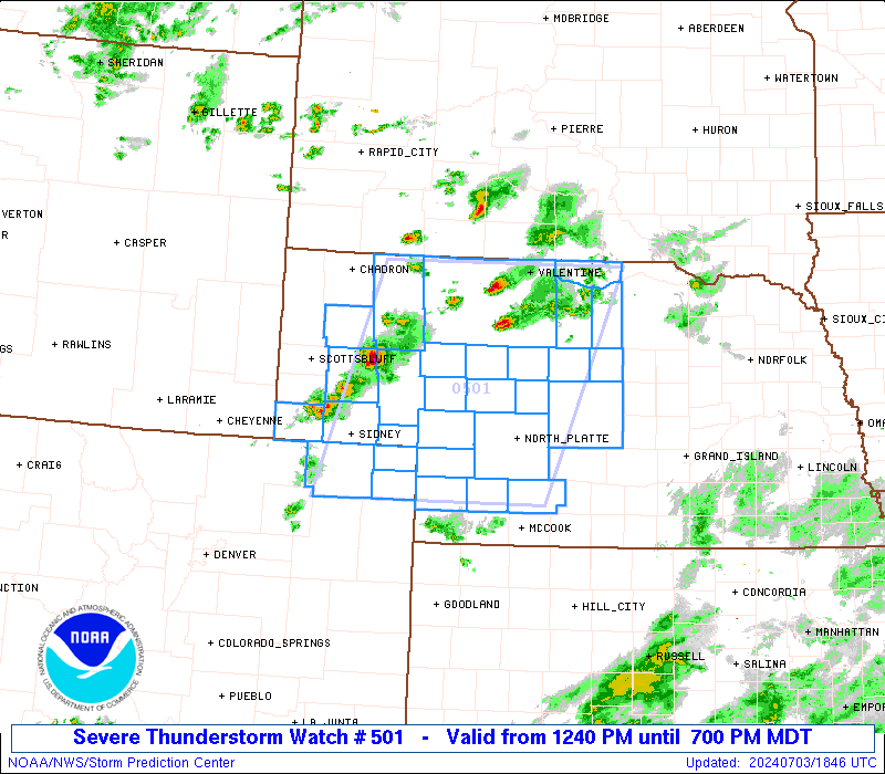
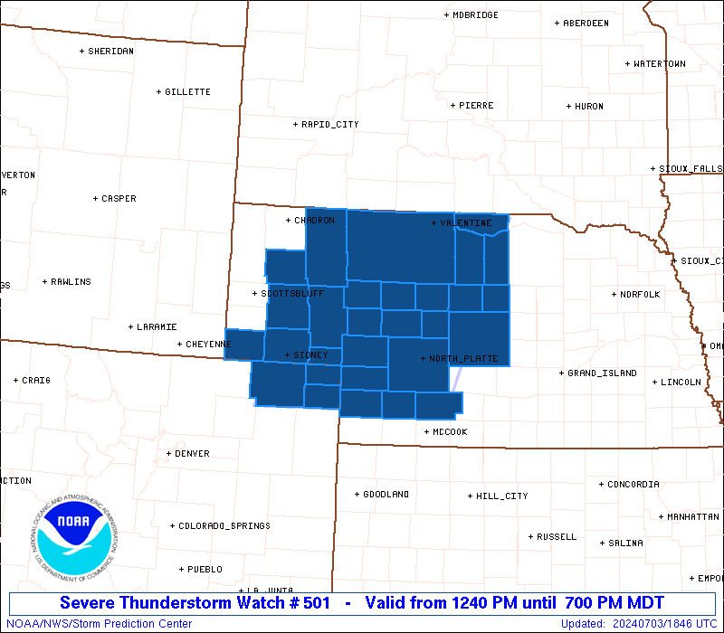
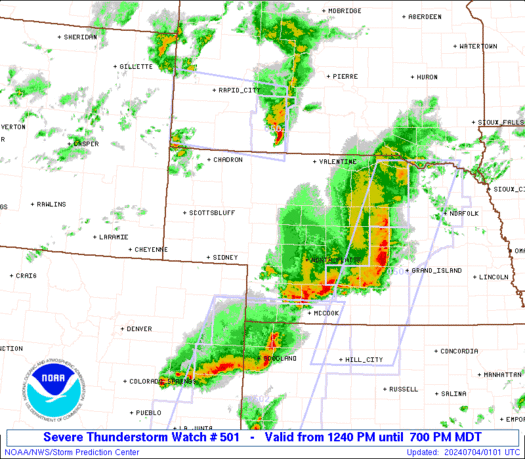
Severe Thunderstorm Watch Number 501
NWS Storm Prediction Center Norman OK
1240 PM MDT Wed Jul 3 2024
The NWS Storm Prediction Center has issued a
* Severe Thunderstorm Watch for portions of
Northeast Colorado
The Nebraska Panhandle into Central Nebraska
* Effective this Wednesday afternoon and evening from 1240 PM
until 700 PM MDT.
* Primary threats include...
Scattered damaging winds likely with isolated significant gusts
to 75 mph possible
Scattered large hail likely with isolated very large hail events
to 3 inches in diameter possible
A tornado or two possible
SUMMARY...Supercell thunderstorms will initially pose a threat for
large hail this afternoon. Some of the hail may be very large, with
isolated hailstones up to 2-3 inches in diameter. Otherwise,
severe/damaging winds around 60-75 mph should become an increasing
concern late this afternoon and evening as thunderstorms potentially
form into a small bowing cluster. A tornado or two also appears
possible, mainly across north-central Nebraska.
The severe thunderstorm watch area is approximately along and 85
statute miles east and west of a line from 20 miles west northwest
of Valentine NE to 15 miles west southwest of Imperial NE. For a
complete depiction of the watch see the associated watch outline
update (WOUS64 KWNS WOU1).
PRECAUTIONARY/PREPAREDNESS ACTIONS...
REMEMBER...A Severe Thunderstorm Watch means conditions are
favorable for severe thunderstorms in and close to the watch area.
Persons in these areas should be on the lookout for threatening
weather conditions and listen for later statements and possible
warnings. Severe thunderstorms can and occasionally do produce
tornadoes.
&&
AVIATION...A few severe thunderstorms with hail surface and aloft to
3 inches. Extreme turbulence and surface wind gusts to 65 knots. A
few cumulonimbi with maximum tops to 500. Mean storm motion vector
27030.
...Gleason

   SEL1

   URGENT - IMMEDIATE BROADCAST REQUESTED
   Severe Thunderstorm Watch Number 501
   NWS Storm Prediction Center Norman OK
   1240 PM MDT Wed Jul 3 2024

   The NWS Storm Prediction Center has issued a

   * Severe Thunderstorm Watch for portions of
     Northeast Colorado
     The Nebraska Panhandle into Central Nebraska

   * Effective this Wednesday afternoon and evening from 1240 PM
     until 700 PM MDT.

   * Primary threats include...
     Scattered damaging winds likely with isolated significant gusts
       to 75 mph possible
     Scattered large hail likely with isolated very large hail events
       to 3 inches in diameter possible
     A tornado or two possible

   SUMMARY...Supercell thunderstorms will initially pose a threat for
   large hail this afternoon. Some of the hail may be very large, with
   isolated hailstones up to 2-3 inches in diameter. Otherwise,
   severe/damaging winds around 60-75 mph should become an increasing
   concern late this afternoon and evening as thunderstorms potentially
   form into a small bowing cluster. A tornado or two also appears
   possible, mainly across north-central Nebraska.

   The severe thunderstorm watch area is approximately along and 85
   statute miles east and west of a line from 20 miles west northwest
   of Valentine NE to 15 miles west southwest of Imperial NE. For a
   complete depiction of the watch see the associated watch outline
   update (WOUS64 KWNS WOU1).

   PRECAUTIONARY/PREPAREDNESS ACTIONS...

   REMEMBER...A Severe Thunderstorm Watch means conditions are
   favorable for severe thunderstorms in and close to the watch area.
   Persons in these areas should be on the lookout for threatening
   weather conditions and listen for later statements and possible
   warnings. Severe thunderstorms can and occasionally do produce
   tornadoes.

   &&

   AVIATION...A few severe thunderstorms with hail surface and aloft to
   3 inches. Extreme turbulence and surface wind gusts to 65 knots. A
   few cumulonimbi with maximum tops to 500. Mean storm motion vector
   27030.

   ...Gleason
 Note:
The Aviation Watch (SAW) product is an approximation to the watch area.
The actual watch is depicted by the shaded areas.
Note:
The Aviation Watch (SAW) product is an approximation to the watch area.
The actual watch is depicted by the shaded areas.
   SAW1
   WW 501 SEVERE TSTM CO NE 031840Z - 040100Z
   AXIS..85 STATUTE MILES EAST AND WEST OF LINE..
   20WNW VTN/VALENTINE NE/ - 15WSW IML/IMPERIAL NE/
   ..AVIATION COORDS.. 75NM E/W /47WNW ANW - 61WNW MCK/
   HAIL SURFACE AND ALOFT..3 INCHES. WIND GUSTS..65 KNOTS.
   MAX TOPS TO 500. MEAN STORM MOTION VECTOR 27030.

   LAT...LON 42959923 40430027 40430350 42950260

   THIS IS AN APPROXIMATION TO THE WATCH AREA.  FOR A
   COMPLETE DEPICTION OF THE WATCH SEE WOUS64 KWNS
   FOR WOU1.
Watch 501 Status Report Messages:
STATUS REPORT #4 ON WW 501

VALID 032330Z - 040040Z

SEVERE WEATHER THREAT CONTINUES RIGHT OF A LINE FROM 20 WSW AKO
TO 30 SSE SNY TO 20 NE CDR.

FOR ADDITIONAL INFORMATION SEE MESOSCALE DISCUSSION 1525

..MOORE..07/03/24

ATTN...WFO...BOU...LBF...CYS...

&&

STATUS REPORT FOR WS 501

SEVERE WEATHER THREAT CONTINUES FOR THE FOLLOWING AREAS

COC039-073-095-115-121-040040-

CO
.    COLORADO COUNTIES INCLUDED ARE

ELBERT		     LINCOLN		 PHILLIPS
SEDGWICK	     WASHINGTON
$$


NEC005-009-015-017-029-031-041-049-063-069-071-075-085-089-091-
101-103-111-113-115-117-135-149-161-171-183-040040-

NE
.    NEBRASKA COUNTIES INCLUDED ARE

ARTHUR		     BLAINE		 BOYD
BROWN		     CHASE		 CHERRY
CUSTER		     DEUEL		 FRONTIER
GARDEN		     GARFIELD		 GRANT
HAYES		     HOLT		 HOOKER
KEITH		     KEYA PAHA		 LINCOLN
LOGAN		     LOUP		 MCPHERSON
PERKINS 	     ROCK		 SHERIDAN
THOMAS		     WHEELER
$$


THE WATCH STATUS MESSAGE IS FOR GUIDANCE PURPOSES ONLY.  PLEASE
REFER TO WATCH COUNTY NOTIFICATION STATEMENTS FOR OFFICIAL
INFORMATION ON COUNTIES...INDEPENDENT CITIES AND MARINE ZONES
CLEARED FROM SEVERE THUNDERSTORM AND TORNADO WATCHES.
$$

STATUS REPORT #3 ON WW 501

VALID 032225Z - 032340Z

SEVERE WEATHER THREAT CONTINUES RIGHT OF A LINE FROM 50 ESE CYS
TO 30 SSW AIA TO 20 NE CDR.

FOR ADDITIONAL INFORMATION SEE MESOSCALE DISCUSSION 1524

..MOORE..07/03/24

ATTN...WFO...BOU...LBF...CYS...

&&

STATUS REPORT FOR WS 501

SEVERE WEATHER THREAT CONTINUES FOR THE FOLLOWING AREAS

COC039-073-075-095-115-121-032340-

CO
.    COLORADO COUNTIES INCLUDED ARE

ELBERT		     LINCOLN		 LOGAN
PHILLIPS	     SEDGWICK		 WASHINGTON
$$


NEC005-009-017-029-031-033-041-049-063-069-075-085-091-101-103-
111-113-115-117-135-149-161-171-032340-

NE
.    NEBRASKA COUNTIES INCLUDED ARE

ARTHUR		     BLAINE		 BROWN
CHASE		     CHERRY		 CHEYENNE
CUSTER		     DEUEL		 FRONTIER
GARDEN		     GRANT		 HAYES
HOOKER		     KEITH		 KEYA PAHA
LINCOLN 	     LOGAN		 LOUP
MCPHERSON	     PERKINS		 ROCK
SHERIDAN	     THOMAS
$$


THE WATCH STATUS MESSAGE IS FOR GUIDANCE PURPOSES ONLY.  PLEASE
REFER TO WATCH COUNTY NOTIFICATION STATEMENTS FOR OFFICIAL
INFORMATION ON COUNTIES...INDEPENDENT CITIES AND MARINE ZONES
CLEARED FROM SEVERE THUNDERSTORM AND TORNADO WATCHES.
$$

STATUS REPORT #2 ON WW 501

VALID 032105Z - 032240Z

SEVERE WEATHER THREAT CONTINUES RIGHT OF A LINE FROM 50 ESE CYS
TO 25 SSW AIA TO 20 NE CDR.

..MOORE..07/03/24

ATTN...WFO...BOU...LBF...CYS...

&&

STATUS REPORT FOR WS 501

SEVERE WEATHER THREAT CONTINUES FOR THE FOLLOWING AREAS

COC075-095-115-032240-

CO
.    COLORADO COUNTIES INCLUDED ARE

LOGAN		     PHILLIPS		 SEDGWICK
$$


NEC005-009-017-029-031-033-041-049-063-069-075-085-091-101-103-
111-113-115-117-135-149-161-171-032240-

NE
.    NEBRASKA COUNTIES INCLUDED ARE

ARTHUR		     BLAINE		 BROWN
CHASE		     CHERRY		 CHEYENNE
CUSTER		     DEUEL		 FRONTIER
GARDEN		     GRANT		 HAYES
HOOKER		     KEITH		 KEYA PAHA
LINCOLN 	     LOGAN		 LOUP
MCPHERSON	     PERKINS		 ROCK
SHERIDAN	     THOMAS
$$


THE WATCH STATUS MESSAGE IS FOR GUIDANCE PURPOSES ONLY.  PLEASE
REFER TO WATCH COUNTY NOTIFICATION STATEMENTS FOR OFFICIAL
INFORMATION ON COUNTIES...INDEPENDENT CITIES AND MARINE ZONES
CLEARED FROM SEVERE THUNDERSTORM AND TORNADO WATCHES.
$$

STATUS REPORT #1 ON WW 501

VALID 032010Z - 032140Z

THE SEVERE WEATHER THREAT CONTINUES ACROSS THE ENTIRE WATCH AREA.

..THORNTON..07/03/24

ATTN...WFO...BOU...LBF...CYS...

&&

STATUS REPORT FOR WS 501

SEVERE WEATHER THREAT CONTINUES FOR THE FOLLOWING AREAS

COC075-095-115-032140-

CO
.    COLORADO COUNTIES INCLUDED ARE

LOGAN		     PHILLIPS		 SEDGWICK
$$


NEC005-009-013-017-029-031-033-041-049-063-069-075-085-091-101-
103-105-111-113-115-117-123-135-149-161-171-032140-

NE
.    NEBRASKA COUNTIES INCLUDED ARE

ARTHUR		     BLAINE		 BOX BUTTE
BROWN		     CHASE		 CHERRY
CHEYENNE	     CUSTER		 DEUEL
FRONTIER	     GARDEN		 GRANT
HAYES		     HOOKER		 KEITH
KEYA PAHA	     KIMBALL		 LINCOLN
LOGAN		     LOUP		 MCPHERSON
MORRILL 	     PERKINS		 ROCK
SHERIDAN	     THOMAS
$$


THE WATCH STATUS MESSAGE IS FOR GUIDANCE PURPOSES ONLY.  PLEASE
REFER TO WATCH COUNTY NOTIFICATION STATEMENTS FOR OFFICIAL
INFORMATION ON COUNTIES...INDEPENDENT CITIES AND MARINE ZONES
CLEARED FROM SEVERE THUNDERSTORM AND TORNADO WATCHES.
$$
Note:
Click for Complete Product Text.
Tornadoes
Probability of 2 or more tornadoes
|
Low (20%)
|
Probability of 1 or more strong (EF2-EF5) tornadoes
|
Low (10%)
|
Wind
Probability of 10 or more severe wind events
|
Mod (60%)
|
Probability of 1 or more wind events > 65 knots
|
Mod (30%)
|
Hail
Probability of 10 or more severe hail events
|
Mod (60%)
|
Probability of 1 or more hailstones > 2 inches
|
Mod (40%)
|
Combined Severe Hail/Wind
Probability of 6 or more combined severe hail/wind events
|
High (90%)
|
For each watch, probabilities for particular events inside the watch
(listed above in each table) are determined by the issuing forecaster.
The "Low" category contains probability values ranging from less than 2%
to 20% (EF2-EF5 tornadoes), less than 5% to 20% (all other probabilities),
"Moderate" from 30% to 60%, and "High" from 70% to greater than 95%.
High values are bolded and lighter in color to provide awareness of
an increased threat for a particular event.


 @NWSSPC