|
| Mesoscale Discussion 1530 |
|
< Previous MD Next MD >
|
|
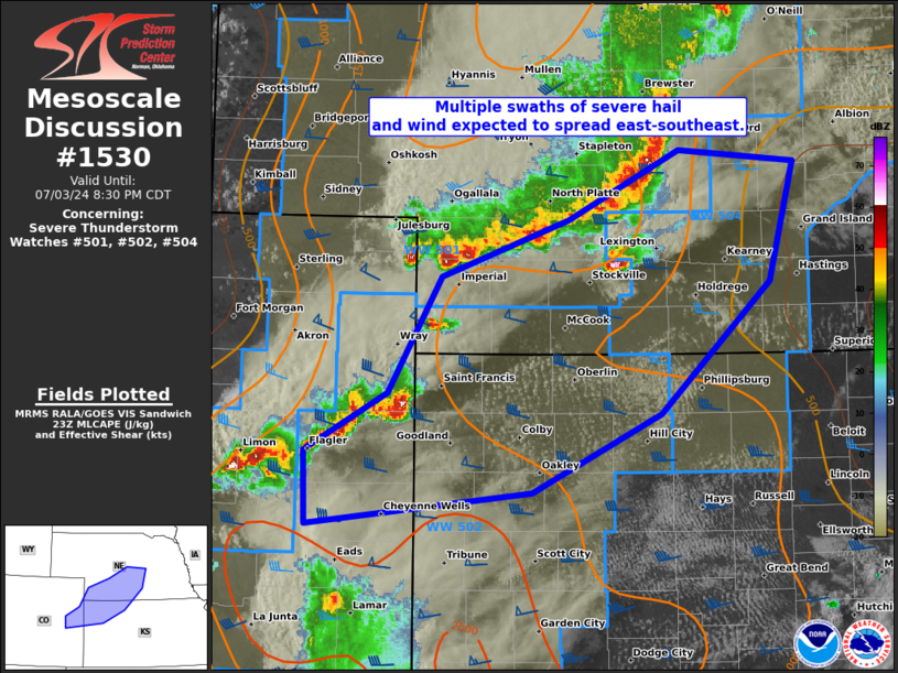
   Mesoscale Discussion 1530
   NWS Storm Prediction Center Norman OK
   0653 PM CDT Wed Jul 03 2024

   Areas affected...southwest/south-central NE...northwest
   KS...east-central CO

   Concerning...Severe Thunderstorm Watch 501...502...504...

   Valid 032353Z - 040130Z

   The severe weather threat for Severe Thunderstorm Watch 501, 502,
   504 continues.

   SUMMARY...Multiple swaths of severe hail and wind are expected to
   evolve east-southeastward across parts of southern Nebraska and
   northwest Kansas through sunset. This will include risks for
   significant severe hail to around 2.5 inches in diameter and wind
   gusts to around 80 mph, as well as a brief tornado or two.

   DISCUSSION...Multiple linear segments/clusters and embedded/discrete
   supercells are ongoing across parts of east-central CO into central
   NE. Moderate buoyancy persists ahead of this activity, with the peak
   axis along the CO/KS border into far southwest NE. Severe wind
   potential will probably be comparatively greater across northwest KS
   as the east-central CO spreads across this buoyancy plume, a
   scenario continuing to be advertised by recent WoFS guidance. This
   may yield gusts from 65-80 mph. Farther northeast, measured wind
   gusts have been generally strong owing to the slow-moving and
   backbuilding nature of the QLCS, especially with southwestward
   extent. Still, gusts from 50-65 mph will remain possible from
   southwest into central NE.

   ..Grams.. 07/03/2024

   ...Please see www.spc.noaa.gov for graphic product...

   ATTN...WFO...GID...LBF...GLD...

   LAT...LON   40990058 41509952 41419840 40529865 39559969 38970093
               38730308 39280310 39710231 40560180 40990058
|
|
Top/All Mesoscale Discussions/Forecast Products/Home
|
|


 @NWSSPC