 Note:
The expiration time in the watch graphic is amended if the watch is
replaced, cancelled or extended.
Note:
Note:
The expiration time in the watch graphic is amended if the watch is
replaced, cancelled or extended.
Note: Click for
Watch Status Reports.
SEL0
URGENT - IMMEDIATE BROADCAST REQUESTED
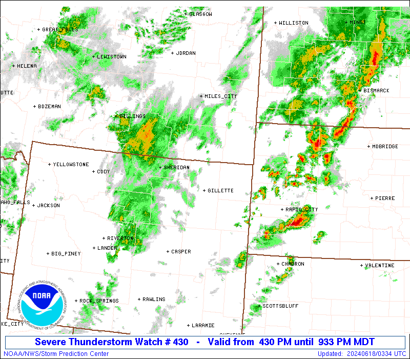
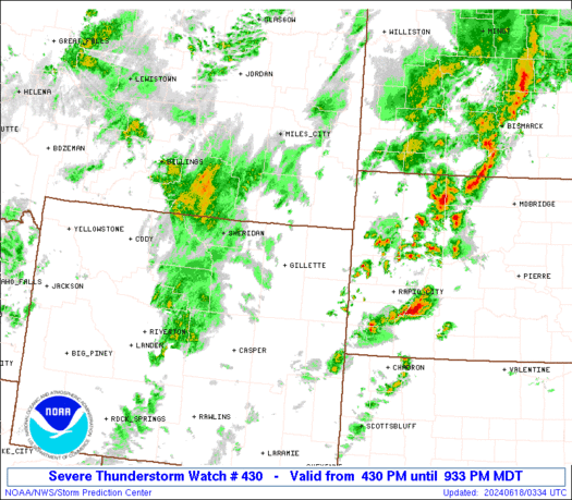
Severe Thunderstorm Watch Number 430
NWS Storm Prediction Center Norman OK
430 PM MDT Mon Jun 17 2024
The NWS Storm Prediction Center has issued a
* Severe Thunderstorm Watch for portions of
Southeastern Montana
East-central and northeastern Wyoming
* Effective this Monday afternoon and evening from 430 PM until
1100 PM MDT.
* Primary threats include...
Scattered large hail and isolated very large hail events to 2
inches in diameter possible
Isolated damaging wind gusts to 70 mph possible
SUMMARY...Thunderstorms should continue to develop on the east side
of higher terrain around the Bighorns and northern Laramie Range,
and move northward to northeastward. Activity should cross a narrow
corridor of favorable instability and shear for large hail and
severe gusts to result, before weakening closer to the Dakotas
border.
The severe thunderstorm watch area is approximately along and 50
statute miles east and west of a line from 110 miles south of
Gillette WY to 30 miles west northwest of Baker MT. For a complete
depiction of the watch see the associated watch outline update
(WOUS64 KWNS WOU0).
PRECAUTIONARY/PREPAREDNESS ACTIONS...
REMEMBER...A Severe Thunderstorm Watch means conditions are
favorable for severe thunderstorms in and close to the watch area.
Persons in these areas should be on the lookout for threatening
weather conditions and listen for later statements and possible
warnings. Severe thunderstorms can and occasionally do produce
tornadoes.
&&
OTHER WATCH INFORMATION...CONTINUE...WW 429...
AVIATION...A few severe thunderstorms with hail surface and aloft to
2 inches. Extreme turbulence and surface wind gusts to 60 knots. A
few cumulonimbi with maximum tops to 500. Mean storm motion vector
21030.
...Edwards

   SEL0

   URGENT - IMMEDIATE BROADCAST REQUESTED
   Severe Thunderstorm Watch Number 430
   NWS Storm Prediction Center Norman OK
   430 PM MDT Mon Jun 17 2024

   The NWS Storm Prediction Center has issued a

   * Severe Thunderstorm Watch for portions of
     Southeastern Montana
     East-central and northeastern Wyoming

   * Effective this Monday afternoon and evening from 430 PM until
     1100 PM MDT.

   * Primary threats include...
     Scattered large hail and isolated very large hail events to 2
       inches in diameter possible
     Isolated damaging wind gusts to 70 mph possible

   SUMMARY...Thunderstorms should continue to develop on the east side
   of higher terrain around the Bighorns and northern Laramie Range,
   and move northward to northeastward.  Activity should cross a narrow
   corridor of favorable instability and shear for large hail and
   severe gusts to result, before weakening closer to the Dakotas
   border.

   The severe thunderstorm watch area is approximately along and 50
   statute miles east and west of a line from 110 miles south of
   Gillette WY to 30 miles west northwest of Baker MT. For a complete
   depiction of the watch see the associated watch outline update
   (WOUS64 KWNS WOU0).

   PRECAUTIONARY/PREPAREDNESS ACTIONS...

   REMEMBER...A Severe Thunderstorm Watch means conditions are
   favorable for severe thunderstorms in and close to the watch area.
   Persons in these areas should be on the lookout for threatening
   weather conditions and listen for later statements and possible
   warnings. Severe thunderstorms can and occasionally do produce
   tornadoes.

   &&

   OTHER WATCH INFORMATION...CONTINUE...WW 429...

   AVIATION...A few severe thunderstorms with hail surface and aloft to
   2 inches. Extreme turbulence and surface wind gusts to 60 knots. A
   few cumulonimbi with maximum tops to 500. Mean storm motion vector
   21030.

   ...Edwards
 Note:
The Aviation Watch (SAW) product is an approximation to the watch area.
The actual watch is depicted by the shaded areas.
Note:
The Aviation Watch (SAW) product is an approximation to the watch area.
The actual watch is depicted by the shaded areas.
   SAW0
   WW 430 SEVERE TSTM MT WY 172230Z - 180500Z
   AXIS..50 STATUTE MILES EAST AND WEST OF LINE..
   110S GCC/GILLETTE WY/ - 30WNW BHK/BAKER MT/
   ..AVIATION COORDS.. 45NM E/W /39ESE DDY - 47E MLS/
   HAIL SURFACE AND ALOFT..2 INCHES. WIND GUSTS..60 KNOTS.
   MAX TOPS TO 500. MEAN STORM MOTION VECTOR 21030.

   LAT...LON 42750652 46520588 46520378 42750454

   THIS IS AN APPROXIMATION TO THE WATCH AREA.  FOR A
   COMPLETE DEPICTION OF THE WATCH SEE WOUS64 KWNS
   FOR WOU0.
Watch 430 Status Report Messages:
STATUS REPORT #4 ON WW 430
VALID 180245Z - 180340Z
SEVERE WEATHER THREAT CONTINUES RIGHT OF A LINE FROM 45 SSW DGW
TO 50 NNE DGW TO 20 SW 2WX.
..DEAN..06/18/24
ATTN...WFO...BYZ...UNR...CYS...RIW...
&&
STATUS REPORT FOR WS 430
SEVERE WEATHER THREAT CONTINUES FOR THE FOLLOWING AREAS
WYC009-027-180340-
WY
. WYOMING COUNTIES INCLUDED ARE
CONVERSE NIOBRARA
$$
THE WATCH STATUS MESSAGE IS FOR GUIDANCE PURPOSES ONLY. PLEASE
REFER TO WATCH COUNTY NOTIFICATION STATEMENTS FOR OFFICIAL
INFORMATION ON COUNTIES...INDEPENDENT CITIES AND MARINE ZONES
CLEARED FROM SEVERE THUNDERSTORM AND TORNADO WATCHES.
$$
STATUS REPORT #3 ON WW 430
VALID 180145Z - 180240Z
SEVERE WEATHER THREAT CONTINUES RIGHT OF A LINE FROM 25 WSW DGW
TO 15 NNE GCC TO 25 SE GDV.
..DEAN..06/18/24
ATTN...WFO...BYZ...UNR...CYS...RIW...
&&
STATUS REPORT FOR WS 430
SEVERE WEATHER THREAT CONTINUES FOR THE FOLLOWING AREAS
MTC011-025-180240-
MT
. MONTANA COUNTIES INCLUDED ARE
CARTER FALLON
$$
WYC005-009-011-027-045-180240-
WY
. WYOMING COUNTIES INCLUDED ARE
CAMPBELL CONVERSE CROOK
NIOBRARA WESTON
$$
THE WATCH STATUS MESSAGE IS FOR GUIDANCE PURPOSES ONLY. PLEASE
REFER TO WATCH COUNTY NOTIFICATION STATEMENTS FOR OFFICIAL
INFORMATION ON COUNTIES...INDEPENDENT CITIES AND MARINE ZONES
CLEARED FROM SEVERE THUNDERSTORM AND TORNADO WATCHES.
$$
STATUS REPORT #2 ON WW 430
VALID 180045Z - 180140Z
SEVERE WEATHER THREAT CONTINUES RIGHT OF A LINE FROM 10 NW CPR TO
55 SW GCC TO 35 E SHR TO 35 NE SHR.
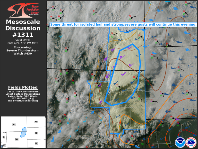
FOR ADDITIONAL INFORMATION SEE MESOSCALE DISCUSSION 1311
..DEAN..06/18/24
ATTN...WFO...BYZ...UNR...CYS...RIW...
&&
STATUS REPORT FOR WS 430
SEVERE WEATHER THREAT CONTINUES FOR THE FOLLOWING AREAS
MTC011-017-025-075-180140-
MT
. MONTANA COUNTIES INCLUDED ARE
CARTER CUSTER FALLON
POWDER RIVER
$$
WYC005-009-011-027-045-180140-
WY
. WYOMING COUNTIES INCLUDED ARE
CAMPBELL CONVERSE CROOK
NIOBRARA WESTON
$$
THE WATCH STATUS MESSAGE IS FOR GUIDANCE PURPOSES ONLY. PLEASE
REFER TO WATCH COUNTY NOTIFICATION STATEMENTS FOR OFFICIAL
INFORMATION ON COUNTIES...INDEPENDENT CITIES AND MARINE ZONES
CLEARED FROM SEVERE THUNDERSTORM AND TORNADO WATCHES.
$$
STATUS REPORT #1 ON WW 430
VALID 172340Z - 180040Z
THE SEVERE WEATHER THREAT CONTINUES ACROSS THE ENTIRE WATCH AREA.
..DEAN..06/17/24
ATTN...WFO...BYZ...UNR...CYS...RIW...
&&
STATUS REPORT FOR WS 430
SEVERE WEATHER THREAT CONTINUES FOR THE FOLLOWING AREAS
MTC011-017-025-075-180040-
MT
. MONTANA COUNTIES INCLUDED ARE
CARTER CUSTER FALLON
POWDER RIVER
$$
WYC005-009-011-019-027-045-180040-
WY
. WYOMING COUNTIES INCLUDED ARE
CAMPBELL CONVERSE CROOK
JOHNSON NIOBRARA WESTON
$$
THE WATCH STATUS MESSAGE IS FOR GUIDANCE PURPOSES ONLY. PLEASE
REFER TO WATCH COUNTY NOTIFICATION STATEMENTS FOR OFFICIAL
INFORMATION ON COUNTIES...INDEPENDENT CITIES AND MARINE ZONES
CLEARED FROM SEVERE THUNDERSTORM AND TORNADO WATCHES.
$$
Note:
Click for Complete Product Text.
Tornadoes
Probability of 2 or more tornadoes
|
Low (<5%)
|
Probability of 1 or more strong (EF2-EF5) tornadoes
|
Low (<2%)
|
Wind
Probability of 10 or more severe wind events
|
Mod (30%)
|
Probability of 1 or more wind events > 65 knots
|
Low (20%)
|
Hail
Probability of 10 or more severe hail events
|
Mod (50%)
|
Probability of 1 or more hailstones > 2 inches
|
Mod (30%)
|
Combined Severe Hail/Wind
Probability of 6 or more combined severe hail/wind events
|
Mod (60%)
|
For each watch, probabilities for particular events inside the watch
(listed above in each table) are determined by the issuing forecaster.
The "Low" category contains probability values ranging from less than 2%
to 20% (EF2-EF5 tornadoes), less than 5% to 20% (all other probabilities),
"Moderate" from 30% to 60%, and "High" from 70% to greater than 95%.
High values are bolded and lighter in color to provide awareness of
an increased threat for a particular event.


 @NWSSPC