 Note:
The expiration time in the watch graphic is amended if the watch is
replaced, cancelled or extended.
Note:
Note:
The expiration time in the watch graphic is amended if the watch is
replaced, cancelled or extended.
Note: Click for
Watch Status Reports.
SEL9
URGENT - IMMEDIATE BROADCAST REQUESTED
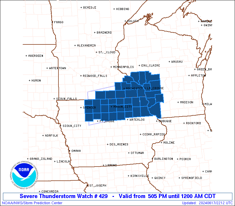
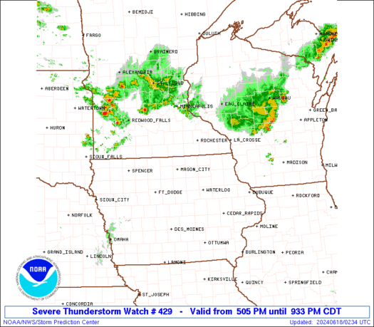
Severe Thunderstorm Watch Number 429
NWS Storm Prediction Center Norman OK
505 PM CDT Mon Jun 17 2024
The NWS Storm Prediction Center has issued a
* Severe Thunderstorm Watch for portions of
Northern Iowa
Southern Minnesota
Southwestern Wisconsin
* Effective this Monday afternoon from 505 PM until Midnight CDT.
* Primary threats include...
Scattered large hail and isolated very large hail events to 2.5
inches in diameter possible
Scattered damaging wind gusts to 70 mph possible
A tornado or two possible
SUMMARY...Thunderstorms are expected to increase in coverage the
next few hours near an outflow-reinforced warm front that will shift
northward through the watch area. In addition to supercell(s) with
large hail and a localized/conditional tornado threat, broader
severe-hail and severe-gust threats also are apparent on either side
of the boundary.
The severe thunderstorm watch area is approximately along and 50
statute miles north and south of a line from 40 miles south
southwest of Fairmont MN to 45 miles east southeast of La Crosse WI.
For a complete depiction of the watch see the associated watch
outline update (WOUS64 KWNS WOU9).
PRECAUTIONARY/PREPAREDNESS ACTIONS...
REMEMBER...A Severe Thunderstorm Watch means conditions are
favorable for severe thunderstorms in and close to the watch area.
Persons in these areas should be on the lookout for threatening
weather conditions and listen for later statements and possible
warnings. Severe thunderstorms can and occasionally do produce
tornadoes.
&&
AVIATION...A few severe thunderstorms with hail surface and aloft to
2.5 inches. Extreme turbulence and surface wind gusts to 60 knots. A
few cumulonimbi with maximum tops to 550. Mean storm motion vector
26025.
...Edwards
SEL9
URGENT - IMMEDIATE BROADCAST REQUESTED
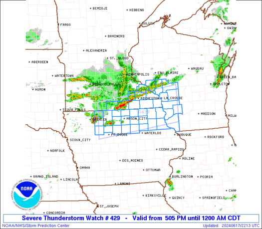
Severe Thunderstorm Watch Number 429
NWS Storm Prediction Center Norman OK
505 PM CDT Mon Jun 17 2024
The NWS Storm Prediction Center has issued a
* Severe Thunderstorm Watch for portions of
Northern Iowa
Southern Minnesota
Southwestern Wisconsin
* Effective this Monday afternoon from 505 PM until Midnight CDT.
* Primary threats include...
Scattered large hail and isolated very large hail events to 2.5
inches in diameter possible
Scattered damaging wind gusts to 70 mph possible
A tornado or two possible
SUMMARY...Thunderstorms are expected to increase in coverage the
next few hours near an outflow-reinforced warm front that will shift
northward through the watch area. In addition to supercell(s) with
large hail and a localized/conditional tornado threat, broader
severe-hail and severe-gust threats also are apparent on either side
of the boundary.
The severe thunderstorm watch area is approximately along and 50
statute miles north and south of a line from 40 miles south
southwest of Fairmont MN to 45 miles east southeast of La Crosse WI.
For a complete depiction of the watch see the associated watch
outline update (WOUS64 KWNS WOU9).
PRECAUTIONARY/PREPAREDNESS ACTIONS...
REMEMBER...A Severe Thunderstorm Watch means conditions are
favorable for severe thunderstorms in and close to the watch area.
Persons in these areas should be on the lookout for threatening
weather conditions and listen for later statements and possible
warnings. Severe thunderstorms can and occasionally do produce
tornadoes.
&&
AVIATION...A few severe thunderstorms with hail surface and aloft to
2.5 inches. Extreme turbulence and surface wind gusts to 60 knots. A
few cumulonimbi with maximum tops to 550. Mean storm motion vector
26025.
...Edwards
 Note:
The Aviation Watch (SAW) product is an approximation to the watch area.
The actual watch is depicted by the shaded areas.
Note:
The Aviation Watch (SAW) product is an approximation to the watch area.
The actual watch is depicted by the shaded areas.
SAW9
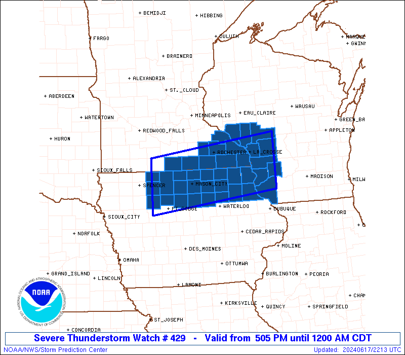
WW 429 SEVERE TSTM IA MN WI 172205Z - 180500Z
AXIS..50 STATUTE MILES NORTH AND SOUTH OF LINE..
40SSW FRM/FAIRMONT MN/ - 45ESE LSE/LA CROSSE WI/
..AVIATION COORDS.. 45NM N/S /36NNW FOD - 29W DLL/
HAIL SURFACE AND ALOFT..2.5 INCHES. WIND GUSTS..60 KNOTS.
MAX TOPS TO 550. MEAN STORM MOTION VECTOR 26025.
LAT...LON 43849472 44359042 42909042 42399472
THIS IS AN APPROXIMATION TO THE WATCH AREA. FOR A
COMPLETE DEPICTION OF THE WATCH SEE WOUS64 KWNS
FOR WOU9.
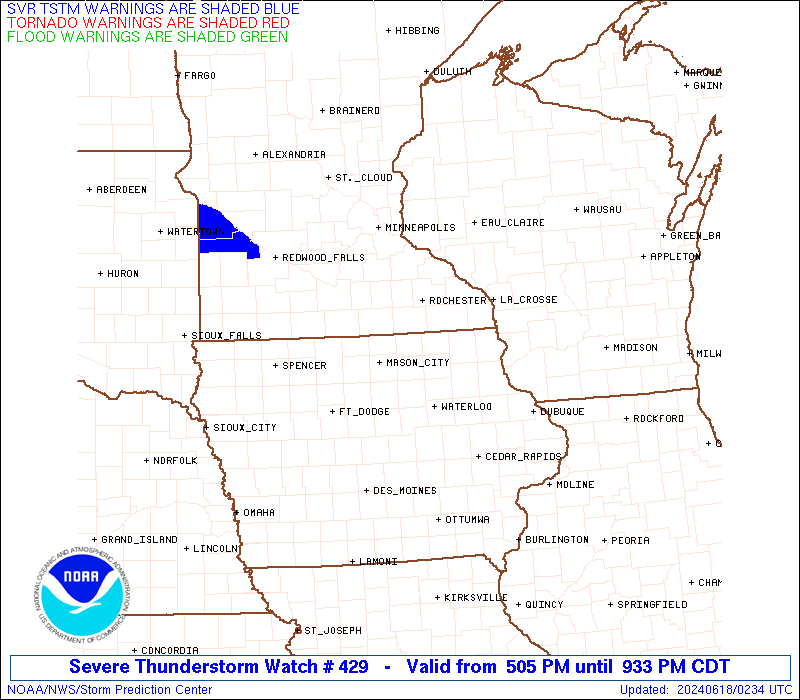
Watch 429 Status Report Messages:
STATUS REPORT #3 ON WW 429
VALID 180135Z - 180240Z
SEVERE WEATHER THREAT CONTINUES RIGHT OF A LINE FROM 15 NNW DBQ
TO 15 WNW LSE TO 45 SE EAU.
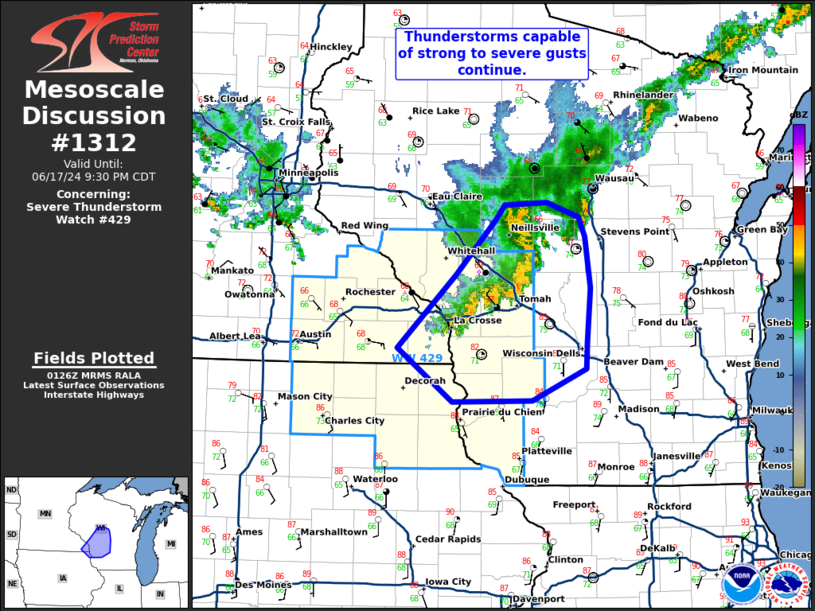
FOR ADDITIONAL INFORMATION SEE MESOSCALE DISCUSSION 1312
..THORNTON..06/18/24
ATTN...WFO...ARX...DMX...MPX...
&&
STATUS REPORT FOR WS 429
SEVERE WEATHER THREAT CONTINUES FOR THE FOLLOWING AREAS
WIC023-043-053-063-081-103-123-180240-
WI
. WISCONSIN COUNTIES INCLUDED ARE
CRAWFORD GRANT JACKSON
LA CROSSE MONROE RICHLAND
VERNON
$$
THE WATCH STATUS MESSAGE IS FOR GUIDANCE PURPOSES ONLY. PLEASE
REFER TO WATCH COUNTY NOTIFICATION STATEMENTS FOR OFFICIAL
INFORMATION ON COUNTIES...INDEPENDENT CITIES AND MARINE ZONES
CLEARED FROM SEVERE THUNDERSTORM AND TORNADO WATCHES.
$$
STATUS REPORT #2 ON WW 429
VALID 180045Z - 180140Z
SEVERE WEATHER THREAT CONTINUES RIGHT OF A LINE FROM 15 ESE ALO
TO 30 NNE ALO TO 25 SE MCW TO 40 S MSP.
..THORNTON..06/18/24
ATTN...WFO...ARX...DMX...MPX...
&&
STATUS REPORT FOR WS 429
SEVERE WEATHER THREAT CONTINUES FOR THE FOLLOWING AREAS
IAC005-037-043-065-067-089-131-147-191-180140-
IA
. IOWA COUNTIES INCLUDED ARE
ALLAMAKEE CHICKASAW CLAYTON
FAYETTE FLOYD HOWARD
MITCHELL PALO ALTO WINNESHIEK
$$
MNC039-045-055-099-109-157-169-180140-
MN
. MINNESOTA COUNTIES INCLUDED ARE
DODGE FILLMORE HOUSTON
MOWER OLMSTED WABASHA
WINONA
$$
WIC011-023-043-053-063-081-103-121-123-180140-
WI
. WISCONSIN COUNTIES INCLUDED ARE
BUFFALO CRAWFORD GRANT
JACKSON LA CROSSE MONROE
RICHLAND TREMPEALEAU VERNON
$$
THE WATCH STATUS MESSAGE IS FOR GUIDANCE PURPOSES ONLY. PLEASE
REFER TO WATCH COUNTY NOTIFICATION STATEMENTS FOR OFFICIAL
INFORMATION ON COUNTIES...INDEPENDENT CITIES AND MARINE ZONES
CLEARED FROM SEVERE THUNDERSTORM AND TORNADO WATCHES.
$$
STATUS REPORT #1 ON WW 429
VALID 180005Z - 180140Z
THE SEVERE WEATHER THREAT CONTINUES ACROSS THE ENTIRE WATCH AREA.
..THORNTON..06/18/24
ATTN...WFO...ARX...DMX...MPX...
&&
STATUS REPORT FOR WS 429
SEVERE WEATHER THREAT CONTINUES FOR THE FOLLOWING AREAS
IAC005-017-023-033-037-043-063-065-067-069-081-089-091-109-131-
147-151-189-191-195-197-180140-
IA
. IOWA COUNTIES INCLUDED ARE
ALLAMAKEE BREMER BUTLER
CERRO GORDO CHICKASAW CLAYTON
EMMET FAYETTE FLOYD
FRANKLIN HANCOCK HOWARD
HUMBOLDT KOSSUTH MITCHELL
PALO ALTO POCAHONTAS WINNEBAGO
WINNESHIEK WORTH WRIGHT
$$
MNC039-043-045-047-055-099-109-157-169-180140-
MN
. MINNESOTA COUNTIES INCLUDED ARE
DODGE FARIBAULT FILLMORE
FREEBORN HOUSTON MOWER
OLMSTED WABASHA WINONA
$$
WIC011-023-043-053-063-081-103-121-123-180140-
WI
. WISCONSIN COUNTIES INCLUDED ARE
BUFFALO CRAWFORD GRANT
JACKSON LA CROSSE MONROE
RICHLAND TREMPEALEAU VERNON
$$
THE WATCH STATUS MESSAGE IS FOR GUIDANCE PURPOSES ONLY. PLEASE
REFER TO WATCH COUNTY NOTIFICATION STATEMENTS FOR OFFICIAL
INFORMATION ON COUNTIES...INDEPENDENT CITIES AND MARINE ZONES
CLEARED FROM SEVERE THUNDERSTORM AND TORNADO WATCHES.
$$
Note:
Click for Complete Product Text.
Tornadoes
Probability of 2 or more tornadoes
|
Low (20%)
|
Probability of 1 or more strong (EF2-EF5) tornadoes
|
Low (5%)
|
Wind
Probability of 10 or more severe wind events
|
Mod (50%)
|
Probability of 1 or more wind events > 65 knots
|
Low (20%)
|
Hail
Probability of 10 or more severe hail events
|
Mod (50%)
|
Probability of 1 or more hailstones > 2 inches
|
Mod (30%)
|
Combined Severe Hail/Wind
Probability of 6 or more combined severe hail/wind events
|
High (80%)
|
For each watch, probabilities for particular events inside the watch
(listed above in each table) are determined by the issuing forecaster.
The "Low" category contains probability values ranging from less than 2%
to 20% (EF2-EF5 tornadoes), less than 5% to 20% (all other probabilities),
"Moderate" from 30% to 60%, and "High" from 70% to greater than 95%.
High values are bolded and lighter in color to provide awareness of
an increased threat for a particular event.


 @NWSSPC