Note:
The expiration time in the watch graphic is amended if the watch is
replaced, cancelled or extended.
Note:
Note:
The expiration time in the watch graphic is amended if the watch is
replaced, cancelled or extended.
Note: Click for
Watch Status Reports.
SEL8
URGENT - IMMEDIATE BROADCAST REQUESTED
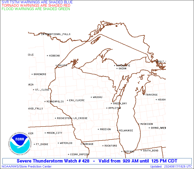
Severe Thunderstorm Watch Number 428
NWS Storm Prediction Center Norman OK
920 AM CDT Mon Jun 17 2024
The NWS Storm Prediction Center has issued a
* Severe Thunderstorm Watch for portions of
The Western Upper Peninsula of Michigan
Northern Wisconsin
Lake Superior
* Effective this Monday morning and afternoon from 920 AM until
400 PM CDT.
* Primary threats include...
Isolated damaging wind gusts to 65 mph possible
Isolated large hail events to 1.5 inches in diameter possible
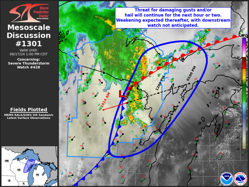
SUMMARY...Thunderstorms spreading northeastward this morning and
afternoon should continue to pose some threat for severe hail around
1-1.5 inches in diameter, along with severe/damaging winds up to
55-65 mph.
The severe thunderstorm watch area is approximately along and 80
statute miles north and south of a line from 20 miles west southwest
of Rhinelander WI to 30 miles east of Iron Mountain MI. For a
complete depiction of the watch see the associated watch outline
update (WOUS64 KWNS WOU8).
PRECAUTIONARY/PREPAREDNESS ACTIONS...
REMEMBER...A Severe Thunderstorm Watch means conditions are
favorable for severe thunderstorms in and close to the watch area.
Persons in these areas should be on the lookout for threatening
weather conditions and listen for later statements and possible
warnings. Severe thunderstorms can and occasionally do produce
tornadoes.
&&
OTHER WATCH INFORMATION...CONTINUE...WW 427...
AVIATION...A few severe thunderstorms with hail surface and aloft to
1.5 inches. Extreme turbulence and surface wind gusts to 55 knots. A
few cumulonimbi with maximum tops to 500. Mean storm motion vector
24035.
...Gleason

   SEL8

   URGENT - IMMEDIATE BROADCAST REQUESTED
   Severe Thunderstorm Watch Number 428
   NWS Storm Prediction Center Norman OK
   920 AM CDT Mon Jun 17 2024

   The NWS Storm Prediction Center has issued a

   * Severe Thunderstorm Watch for portions of
     The Western Upper Peninsula of Michigan
     Northern Wisconsin
     Lake Superior

   * Effective this Monday morning and afternoon from 920 AM until
     400 PM CDT.

   * Primary threats include...
     Isolated damaging wind gusts to 65 mph possible
     Isolated large hail events to 1.5 inches in diameter possible

   SUMMARY...Thunderstorms spreading northeastward this morning and
   afternoon should continue to pose some threat for severe hail around
   1-1.5 inches in diameter, along with severe/damaging winds up to
   55-65 mph.

   The severe thunderstorm watch area is approximately along and 80
   statute miles north and south of a line from 20 miles west southwest
   of Rhinelander WI to 30 miles east of Iron Mountain MI. For a
   complete depiction of the watch see the associated watch outline
   update (WOUS64 KWNS WOU8).

   PRECAUTIONARY/PREPAREDNESS ACTIONS...

   REMEMBER...A Severe Thunderstorm Watch means conditions are
   favorable for severe thunderstorms in and close to the watch area.
   Persons in these areas should be on the lookout for threatening
   weather conditions and listen for later statements and possible
   warnings. Severe thunderstorms can and occasionally do produce
   tornadoes.

   &&

   OTHER WATCH INFORMATION...CONTINUE...WW 427...

   AVIATION...A few severe thunderstorms with hail surface and aloft to
   1.5 inches. Extreme turbulence and surface wind gusts to 55 knots. A
   few cumulonimbi with maximum tops to 500. Mean storm motion vector
   24035.

   ...Gleason
 Note:
The Aviation Watch (SAW) product is an approximation to the watch area.
The actual watch is depicted by the shaded areas.
Note:
The Aviation Watch (SAW) product is an approximation to the watch area.
The actual watch is depicted by the shaded areas.
   SAW8
   WW 428 SEVERE TSTM MI WI LS 171420Z - 172100Z
   AXIS..80 STATUTE MILES NORTH AND SOUTH OF LINE..
   20WSW RHI/RHINELANDER WI/ - 30E IMT/IRON MOUNTAIN MI/
   ..AVIATION COORDS.. 70NM N/S /18WSW RHI - 32S SAW/
   HAIL SURFACE AND ALOFT..1.5 INCHES. WIND GUSTS..55 KNOTS.
   MAX TOPS TO 500. MEAN STORM MOTION VECTOR 24035.

   LAT...LON 46688985 46988750 44668750 44368985

   THIS IS AN APPROXIMATION TO THE WATCH AREA.  FOR A
   COMPLETE DEPICTION OF THE WATCH SEE WOUS64 KWNS
   FOR WOU8.
Watch 428 Status Report Message has not been issued yet.
Note:
Click for Complete Product Text.
Tornadoes
Probability of 2 or more tornadoes
|
Low (10%)
|
Probability of 1 or more strong (EF2-EF5) tornadoes
|
Low (<2%)
|
Wind
Probability of 10 or more severe wind events
|
Mod (30%)
|
Probability of 1 or more wind events > 65 knots
|
Low (10%)
|
Hail
Probability of 10 or more severe hail events
|
Mod (30%)
|
Probability of 1 or more hailstones > 2 inches
|
Low (10%)
|
Combined Severe Hail/Wind
Probability of 6 or more combined severe hail/wind events
|
Mod (60%)
|
For each watch, probabilities for particular events inside the watch
(listed above in each table) are determined by the issuing forecaster.
The "Low" category contains probability values ranging from less than 2%
to 20% (EF2-EF5 tornadoes), less than 5% to 20% (all other probabilities),
"Moderate" from 30% to 60%, and "High" from 70% to greater than 95%.
High values are bolded and lighter in color to provide awareness of
an increased threat for a particular event.


 @NWSSPC