 Note:
The expiration time in the watch graphic is amended if the watch is
replaced, cancelled or extended.
Note:
Note:
The expiration time in the watch graphic is amended if the watch is
replaced, cancelled or extended.
Note: Click for
Watch Status Reports.
SEL0
URGENT - IMMEDIATE BROADCAST REQUESTED
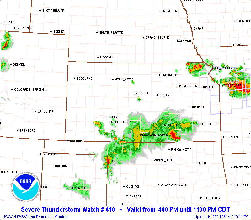
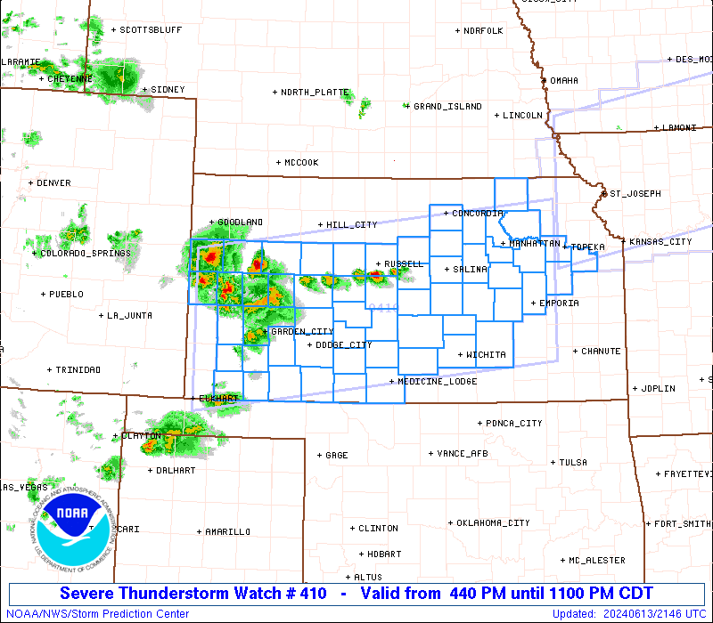
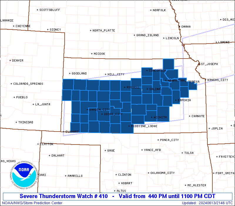
Severe Thunderstorm Watch Number 410
NWS Storm Prediction Center Norman OK
440 PM CDT Thu Jun 13 2024
The NWS Storm Prediction Center has issued a
* Severe Thunderstorm Watch for portions of
Much of Kansas
* Effective this Thursday afternoon and evening from 440 PM until
1100 PM CDT.
* Primary threats include...
Widespread damaging winds and isolated significant gusts to 85
mph likely
Scattered large hail and isolated very large hail events to 3
inches in diameter possible
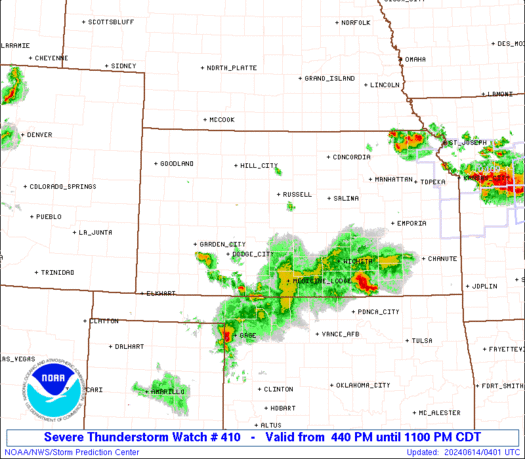
SUMMARY...Scattered thunderstorms are forecast to continue to
develop late this afternoon into the early evening. Several
clusters of severe thunderstorms will likely evolve and pose a risk
for severe gusts potentially ranging between 60-85 mph. Large to
very large hail is possible with the more intense storms mainly from
central parts of Kansas eastward into eastern Kansas.
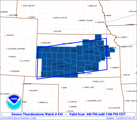
The severe thunderstorm watch area is approximately along and 75
statute miles north and south of a line from 65 miles west of Garden
City KS to 30 miles northeast of Emporia KS. For a complete
depiction of the watch see the associated watch outline update
(WOUS64 KWNS WOU0).
PRECAUTIONARY/PREPAREDNESS ACTIONS...
REMEMBER...A Severe Thunderstorm Watch means conditions are
favorable for severe thunderstorms in and close to the watch area.
Persons in these areas should be on the lookout for threatening
weather conditions and listen for later statements and possible
warnings. Severe thunderstorms can and occasionally do produce
tornadoes.
&&
OTHER WATCH INFORMATION...CONTINUE...WW 408...WW 409...
AVIATION...A few severe thunderstorms with hail surface and aloft to
3 inches. Extreme turbulence and surface wind gusts to 75 knots. A
few cumulonimbi with maximum tops to 500. Mean storm motion vector
29025.
...Smith
 Note:
The Aviation Watch (SAW) product is an approximation to the watch area.
The actual watch is depicted by the shaded areas.
Note:
The Aviation Watch (SAW) product is an approximation to the watch area.
The actual watch is depicted by the shaded areas.
   SAW0
   WW 410 SEVERE TSTM KS 132140Z - 140400Z
   AXIS..75 STATUTE MILES NORTH AND SOUTH OF LINE..
   65W GCK/GARDEN CITY KS/ - 30NE EMP/EMPORIA KS/
   ..AVIATION COORDS.. 65NM N/S /40ESE LAA - 63SW MCI/
   HAIL SURFACE AND ALOFT..3 INCHES. WIND GUSTS..75 KNOTS.
   MAX TOPS TO 500. MEAN STORM MOTION VECTOR 29025.

   LAT...LON 39000191 39729579 37559579 36840191

   THIS IS AN APPROXIMATION TO THE WATCH AREA.  FOR A
   COMPLETE DEPICTION OF THE WATCH SEE WOUS64 KWNS
   FOR WOU0.
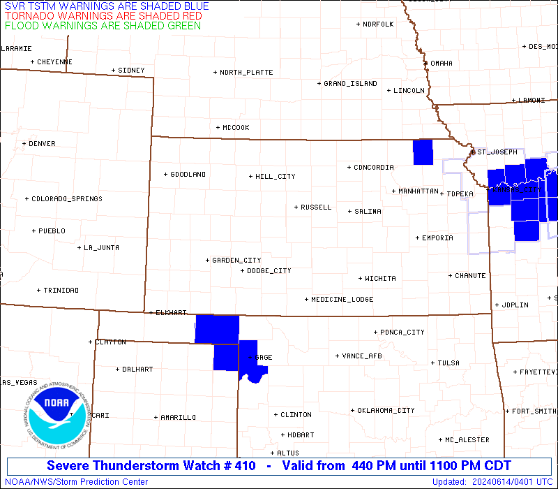
Watch 410 Status Report Messages:
STATUS REPORT #4 ON WW 410

VALID 140240Z - 140340Z

SEVERE WEATHER THREAT CONTINUES RIGHT OF A LINE FROM 10 SE LBL TO
25 WNW P28 TO 15 E ICT TO 35 ENE EMP.

..THORNTON..06/14/24

ATTN...WFO...DDC...ICT...TOP...GLD...

&&

STATUS REPORT FOR WS 410

SEVERE WEATHER THREAT CONTINUES FOR THE FOLLOWING AREAS

KSC007-015-033-045-077-139-177-191-140340-

KS
.    KANSAS COUNTIES INCLUDED ARE

BARBER		     BUTLER		 COMANCHE
DOUGLAS 	     HARPER		 OSAGE
SHAWNEE 	     SUMNER
$$


THE WATCH STATUS MESSAGE IS FOR GUIDANCE PURPOSES ONLY.  PLEASE
REFER TO WATCH COUNTY NOTIFICATION STATEMENTS FOR OFFICIAL
INFORMATION ON COUNTIES...INDEPENDENT CITIES AND MARINE ZONES
CLEARED FROM SEVERE THUNDERSTORM AND TORNADO WATCHES.
$$

STATUS REPORT #3 ON WW 410

VALID 140150Z - 140240Z

SEVERE WEATHER THREAT CONTINUES RIGHT OF A LINE FROM 15 NW GUY TO
50 SSW RSL TO 40 WNW HUT TO 20 NNW RSL TO 30 WNW SLN TO 20 NNW
MHK TO 30 WSW FNB.

..THORNTON..06/14/24

ATTN...WFO...DDC...ICT...TOP...GLD...

&&

STATUS REPORT FOR WS 410

SEVERE WEATHER THREAT CONTINUES FOR THE FOLLOWING AREAS

KSC007-015-017-025-033-041-045-053-061-077-079-095-097-111-113-
115-119-127-139-149-151-155-159-161-167-169-173-175-177-185-191-
197-140240-

KS
.    KANSAS COUNTIES INCLUDED ARE

BARBER		     BUTLER		 CHASE
CLARK		     COMANCHE		 DICKINSON
DOUGLAS 	     ELLSWORTH		 GEARY
HARPER		     HARVEY		 KINGMAN
KIOWA		     LYON		 MCPHERSON
MARION		     MEADE		 MORRIS
OSAGE		     POTTAWATOMIE	 PRATT
RENO		     RICE		 RILEY
RUSSELL 	     SALINE		 SEDGWICK
SEWARD		     SHAWNEE		 STAFFORD
SUMNER		     WABAUNSEE
$$


THE WATCH STATUS MESSAGE IS FOR GUIDANCE PURPOSES ONLY.  PLEASE
REFER TO WATCH COUNTY NOTIFICATION STATEMENTS FOR OFFICIAL
INFORMATION ON COUNTIES...INDEPENDENT CITIES AND MARINE ZONES
CLEARED FROM SEVERE THUNDERSTORM AND TORNADO WATCHES.
$$

STATUS REPORT #2 ON WW 410

VALID 140045Z - 140140Z

SEVERE WEATHER THREAT CONTINUES RIGHT OF A LINE FROM 30 NE SPD TO
40 NNE GCK TO 25 NNW RSL TO 30 WNW SLN TO 20 NNW MHK TO 30 WSW
FNB.

FOR ADDITIONAL INFORMATION SEE MESOSCALE DISCUSSION 1254

..THORNTON..06/14/24

ATTN...WFO...DDC...ICT...TOP...GLD...

&&

STATUS REPORT FOR WS 410

SEVERE WEATHER THREAT CONTINUES FOR THE FOLLOWING AREAS

KSC007-009-015-017-025-033-041-045-047-051-053-055-057-061-067-
069-077-079-081-083-095-097-111-113-115-119-127-135-139-145-149-
151-155-159-161-165-167-169-173-175-177-185-189-191-197-
140140-

KS
.    KANSAS COUNTIES INCLUDED ARE

BARBER		     BARTON		 BUTLER
CHASE		     CLARK		 COMANCHE
DICKINSON	     DOUGLAS		 EDWARDS
ELLIS		     ELLSWORTH		 FINNEY
FORD		     GEARY		 GRANT
GRAY		     HARPER		 HARVEY
HASKELL 	     HODGEMAN		 KINGMAN
KIOWA		     LYON		 MCPHERSON
MARION		     MEADE		 MORRIS
NESS		     OSAGE		 PAWNEE
POTTAWATOMIE	     PRATT		 RENO
RICE		     RILEY		 RUSH
RUSSELL 	     SALINE		 SEDGWICK
SEWARD		     SHAWNEE		 STAFFORD
STEVENS 	     SUMNER		 WABAUNSEE
$$


THE WATCH STATUS MESSAGE IS FOR GUIDANCE PURPOSES ONLY.  PLEASE
REFER TO WATCH COUNTY NOTIFICATION STATEMENTS FOR OFFICIAL
INFORMATION ON COUNTIES...INDEPENDENT CITIES AND MARINE ZONES
CLEARED FROM SEVERE THUNDERSTORM AND TORNADO WATCHES.
$$

STATUS REPORT #1 ON WW 410

VALID 132300Z - 140040Z

THE SEVERE WEATHER THREAT CONTINUES ACROSS THE ENTIRE WATCH AREA.

..THORNTON..06/13/24

ATTN...WFO...DDC...ICT...TOP...GLD...

&&

STATUS REPORT FOR WS 410

SEVERE WEATHER THREAT CONTINUES FOR THE FOLLOWING AREAS

KSC007-009-015-017-025-027-029-033-041-045-047-051-053-055-057-
061-063-067-069-071-079-081-083-093-095-097-101-105-109-111-113-
115-117-119-127-135-139-143-145-149-151-155-159-161-165-167-169-
171-173-175-177-185-189-195-197-199-203-140040-

KS
.    KANSAS COUNTIES INCLUDED ARE

BARBER		     BARTON		 BUTLER
CHASE		     CLARK		 CLAY
CLOUD		     COMANCHE		 DICKINSON
DOUGLAS 	     EDWARDS		 ELLIS
ELLSWORTH	     FINNEY		 FORD
GEARY		     GOVE		 GRANT
GRAY		     GREELEY		 HARVEY
HASKELL 	     HODGEMAN		 KEARNY
KINGMAN 	     KIOWA		 LANE
LINCOLN 	     LOGAN		 LYON
MCPHERSON	     MARION		 MARSHALL
MEADE		     MORRIS		 NESS
OSAGE		     OTTAWA		 PAWNEE
POTTAWATOMIE	     PRATT		 RENO
RICE		     RILEY		 RUSH
RUSSELL 	     SALINE		 SCOTT
SEDGWICK	     SEWARD		 SHAWNEE
STAFFORD	     STEVENS		 TREGO
WABAUNSEE	     WALLACE		 WICHITA
$$


THE WATCH STATUS MESSAGE IS FOR GUIDANCE PURPOSES ONLY.  PLEASE
REFER TO WATCH COUNTY NOTIFICATION STATEMENTS FOR OFFICIAL
INFORMATION ON COUNTIES...INDEPENDENT CITIES AND MARINE ZONES
CLEARED FROM SEVERE THUNDERSTORM AND TORNADO WATCHES.
$$
Note:
Click for Complete Product Text.
Tornadoes
Probability of 2 or more tornadoes
|
Low (10%)
|
Probability of 1 or more strong (EF2-EF5) tornadoes
|
Low (<2%)
|
Wind
Probability of 10 or more severe wind events
|
High (80%)
|
Probability of 1 or more wind events > 65 knots
|
High (70%)
|
Hail
Probability of 10 or more severe hail events
|
Mod (40%)
|
Probability of 1 or more hailstones > 2 inches
|
Mod (30%)
|
Combined Severe Hail/Wind
Probability of 6 or more combined severe hail/wind events
|
High (>95%)
|
For each watch, probabilities for particular events inside the watch
(listed above in each table) are determined by the issuing forecaster.
The "Low" category contains probability values ranging from less than 2%
to 20% (EF2-EF5 tornadoes), less than 5% to 20% (all other probabilities),
"Moderate" from 30% to 60%, and "High" from 70% to greater than 95%.
High values are bolded and lighter in color to provide awareness of
an increased threat for a particular event.


 @NWSSPC