 Note:
The expiration time in the watch graphic is amended if the watch is
replaced, cancelled or extended.
Note:
Note:
The expiration time in the watch graphic is amended if the watch is
replaced, cancelled or extended.
Note: Click for
Watch Status Reports.
SEL8
URGENT - IMMEDIATE BROADCAST REQUESTED
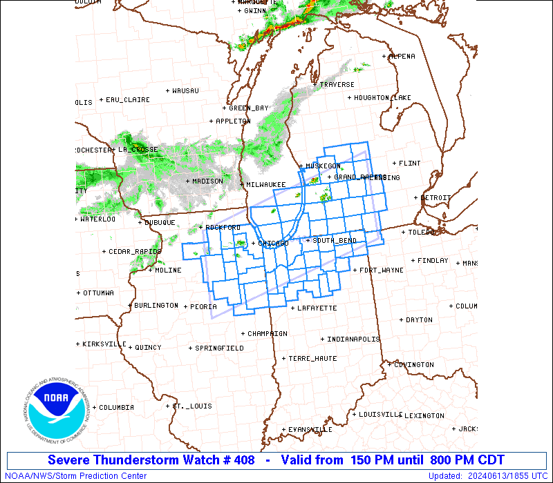
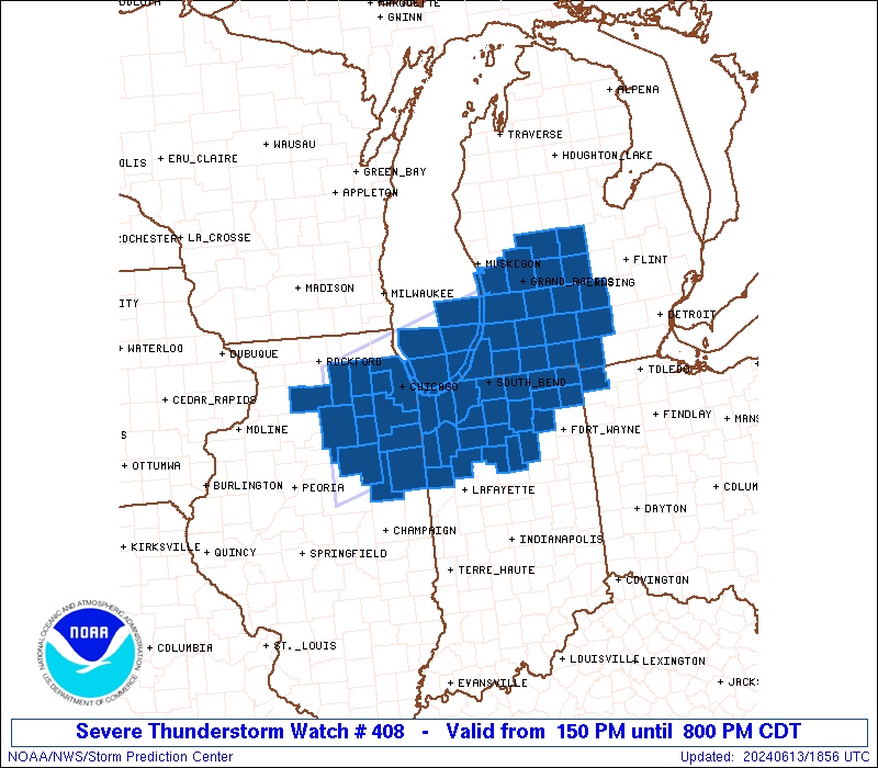
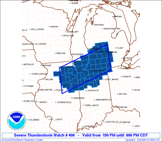
Severe Thunderstorm Watch Number 408
NWS Storm Prediction Center Norman OK
150 PM CDT Thu Jun 13 2024
The NWS Storm Prediction Center has issued a
* Severe Thunderstorm Watch for portions of
Northern Illinois
Northern Indiana
Southern and Central Lower Michigan
Far Northwest Ohio
Lake Michigan
* Effective this Thursday afternoon and evening from 150 PM until
800 PM CDT.
* Primary threats include...
Scattered large hail and isolated very large hail events to 2.5
inches in diameter possible
Scattered damaging wind gusts to 70 mph possible
A tornado or two possible
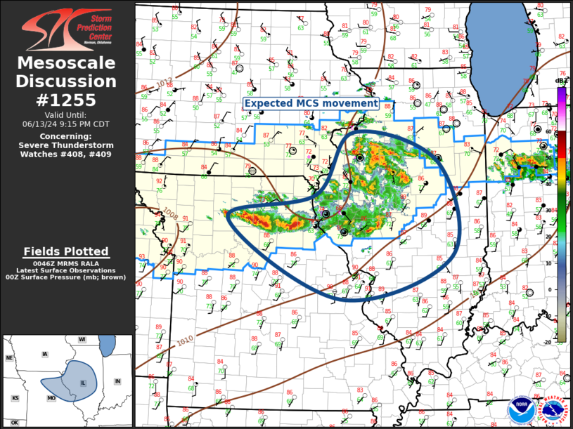
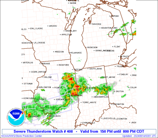
SUMMARY...Thunderstorms are expected to continue increasing in
coverage this afternoon while posing a threat for large hail around
1.5-2.5 inches in diameter. Severe/damaging winds of 60-70 mph may
also occur as convection moves east-southeastward and potentially
grows into one or more small clusters through the afternoon and
early evening.
The severe thunderstorm watch area is approximately along and 60
statute miles north and south of a line from 20 miles west southwest
of Marseilles IL to 10 miles north of Jackson MI. For a complete
depiction of the watch see the associated watch outline update
(WOUS64 KWNS WOU8).
PRECAUTIONARY/PREPAREDNESS ACTIONS...
REMEMBER...A Severe Thunderstorm Watch means conditions are
favorable for severe thunderstorms in and close to the watch area.
Persons in these areas should be on the lookout for threatening
weather conditions and listen for later statements and possible
warnings. Severe thunderstorms can and occasionally do produce
tornadoes.
&&
AVIATION...A few severe thunderstorms with hail surface and aloft to
2.5 inches. Extreme turbulence and surface wind gusts to 60 knots. A
few cumulonimbi with maximum tops to 500. Mean storm motion vector
29030.
...Gleason
 Note:
The Aviation Watch (SAW) product is an approximation to the watch area.
The actual watch is depicted by the shaded areas.
Note:
The Aviation Watch (SAW) product is an approximation to the watch area.
The actual watch is depicted by the shaded areas.
SAW8
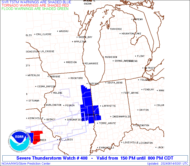
WW 408 SEVERE TSTM IL IN MI OH LM 131850Z - 140100Z
AXIS..60 STATUTE MILES NORTH AND SOUTH OF LINE..
20WSW MMO/MARSEILLES IL/ - 10N JXN/JACKSON MI/
..AVIATION COORDS.. 50NM N/S /26ENE BDF - 46SW FNT/
HAIL SURFACE AND ALOFT..2.5 INCHES. WIND GUSTS..60 KNOTS.
MAX TOPS TO 500. MEAN STORM MOTION VECTOR 29030.
LAT...LON 42138904 43288447 41558447 40398904
THIS IS AN APPROXIMATION TO THE WATCH AREA. FOR A
COMPLETE DEPICTION OF THE WATCH SEE WOUS64 KWNS
FOR WOU8.
Watch 408 Status Report Messages:
STATUS REPORT #2 ON WW 408

VALID 132240Z - 132340Z

SEVERE WEATHER THREAT CONTINUES RIGHT OF A LINE FROM 25 NW MMO TO
5 NW SBN TO 10 S JXN.

..SPC..06/13/24

ATTN...WFO...LOT...IWX...GRR...

&&

STATUS REPORT FOR WS 408

SEVERE WEATHER THREAT CONTINUES FOR THE FOLLOWING AREAS

ILC053-063-075-091-093-099-105-197-132340-

IL
.    ILLINOIS COUNTIES INCLUDED ARE

FORD		     GRUNDY		 IROQUOIS
KANKAKEE	     KENDALL		 LA SALLE
LIVINGSTON	     WILL
$$


INC007-017-033-039-049-073-085-087-089-091-099-103-111-113-127-
131-141-149-151-169-181-183-132340-

IN
.    INDIANA COUNTIES INCLUDED ARE

BENTON		     CASS		 DE KALB
ELKHART 	     FULTON		 JASPER
KOSCIUSKO	     LAGRANGE		 LAKE
LA PORTE	     MARSHALL		 MIAMI
NEWTON		     NOBLE		 PORTER
PULASKI 	     ST. JOSEPH 	 STARKE
STEUBEN 	     WABASH		 WHITE
WHITLEY
$$


MIC021-023-027-059-149-132340-

MI
.    MICHIGAN COUNTIES INCLUDED ARE

BERRIEN 	     BRANCH		 CASS
HILLSDALE	     ST. JOSEPH
$$


OHC171-132340-

OH
.    OHIO COUNTIES INCLUDED ARE

WILLIAMS
$$


LMZ043-046-080-743-744-745-132340-

CW

.    ADJACENT COASTAL WATERS INCLUDED ARE

NEW BUFFALO MI TO ST JOSEPH MI

MICHIGAN CITY IN TO NEW BUFFALO MI

LAKE MICHIGAN MICHIGAN CITY IN TO ST. JOSEPH MI 5 NM OFFSHORE TO
MID-LINE OF LAKE.

CALUMET HARBOR IL TO GARY IN

GARY TO BURNS HARBOR IN

BURNS HARBOR TO MICHIGAN CITY IN

$$
THE WATCH STATUS MESSAGE IS FOR GUIDANCE PURPOSES ONLY.  PLEASE
REFER TO WATCH COUNTY NOTIFICATION STATEMENTS FOR OFFICIAL
INFORMATION ON COUNTIES...INDEPENDENT CITIES AND MARINE ZONES
CLEARED FROM SEVERE THUNDERSTORM AND TORNADO WATCHES.
$$

STATUS REPORT #1 ON WW 408

VALID 132135Z - 132240Z

SEVERE WEATHER THREAT CONTINUES RIGHT OF A LINE FROM 5 SE RFD TO
45 NNW VPZ TO 15 WSW AZO TO 15 N JXN.

..SPC..06/13/24

ATTN...WFO...LOT...IWX...GRR...

&&

STATUS REPORT FOR WS 408

SEVERE WEATHER THREAT CONTINUES FOR THE FOLLOWING AREAS

ILC031-037-043-053-063-075-089-091-093-099-103-105-197-132240-

IL
.    ILLINOIS COUNTIES INCLUDED ARE

COOK		     DE KALB		 DUPAGE
FORD		     GRUNDY		 IROQUOIS
KANE		     KANKAKEE		 KENDALL
LA SALLE	     LEE		 LIVINGSTON
WILL
$$


INC007-017-033-039-049-073-085-087-089-091-099-103-111-113-127-
131-141-149-151-169-181-183-132240-

IN
.    INDIANA COUNTIES INCLUDED ARE

BENTON		     CASS		 DE KALB
ELKHART 	     FULTON		 JASPER
KOSCIUSKO	     LAGRANGE		 LAKE
LA PORTE	     MARSHALL		 MIAMI
NEWTON		     NOBLE		 PORTER
PULASKI 	     ST. JOSEPH 	 STARKE
STEUBEN 	     WABASH		 WHITE
WHITLEY
$$


MIC021-023-025-027-045-059-065-075-077-149-132240-

MI
.    MICHIGAN COUNTIES INCLUDED ARE

BERRIEN 	     BRANCH		 CALHOUN
CASS		     EATON		 HILLSDALE
INGHAM		     JACKSON		 KALAMAZOO
ST. JOSEPH
$$


OHC171-132240-

OH
.    OHIO COUNTIES INCLUDED ARE

WILLIAMS
$$


LMZ043-046-080-741-742-743-744-745-779-132240-

CW

.    ADJACENT COASTAL WATERS INCLUDED ARE

NEW BUFFALO MI TO ST JOSEPH MI

MICHIGAN CITY IN TO NEW BUFFALO MI

LAKE MICHIGAN MICHIGAN CITY IN TO ST. JOSEPH MI 5 NM OFFSHORE TO
MID-LINE OF LAKE.

WILMETTE HARBOR TO NORTHERLY ISLAND IL

NORTHERLY ISLAND TO CALUMET HARBOR IL

CALUMET HARBOR IL TO GARY IN

GARY TO BURNS HARBOR IN

BURNS HARBOR TO MICHIGAN CITY IN

LAKE MICHIGAN FROM WILMETTE HARBOR TO MICHIGAN CITY IN 5NM
OFFSHORE TO MID LAKE

$$
THE WATCH STATUS MESSAGE IS FOR GUIDANCE PURPOSES ONLY.  PLEASE
REFER TO WATCH COUNTY NOTIFICATION STATEMENTS FOR OFFICIAL
INFORMATION ON COUNTIES...INDEPENDENT CITIES AND MARINE ZONES
CLEARED FROM SEVERE THUNDERSTORM AND TORNADO WATCHES.
$$
Note:
Click for Complete Product Text.
Tornadoes
Probability of 2 or more tornadoes
|
Low (20%)
|
Probability of 1 or more strong (EF2-EF5) tornadoes
|
Low (5%)
|
Wind
Probability of 10 or more severe wind events
|
Mod (40%)
|
Probability of 1 or more wind events > 65 knots
|
Low (20%)
|
Hail
Probability of 10 or more severe hail events
|
Mod (50%)
|
Probability of 1 or more hailstones > 2 inches
|
Mod (30%)
|
Combined Severe Hail/Wind
Probability of 6 or more combined severe hail/wind events
|
High (70%)
|
For each watch, probabilities for particular events inside the watch
(listed above in each table) are determined by the issuing forecaster.
The "Low" category contains probability values ranging from less than 2%
to 20% (EF2-EF5 tornadoes), less than 5% to 20% (all other probabilities),
"Moderate" from 30% to 60%, and "High" from 70% to greater than 95%.
High values are bolded and lighter in color to provide awareness of
an increased threat for a particular event.


 @NWSSPC