Note:
The expiration time in the watch graphic is amended if the watch is
replaced, cancelled or extended.
Note:
Note:
The expiration time in the watch graphic is amended if the watch is
replaced, cancelled or extended.
Note: Click for
Watch Status Reports.
SEL1
URGENT - IMMEDIATE BROADCAST REQUESTED
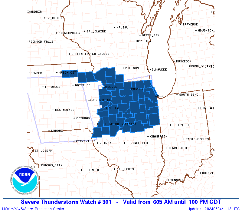
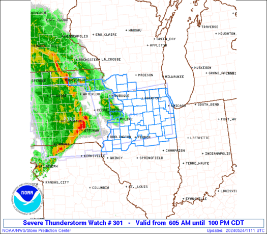
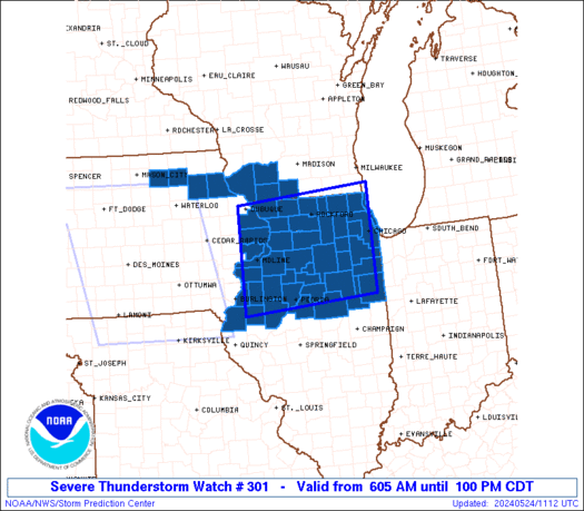
Severe Thunderstorm Watch Number 301
NWS Storm Prediction Center Norman OK
605 AM CDT Fri May 24 2024
The NWS Storm Prediction Center has issued a
* Severe Thunderstorm Watch for portions of
Eastern and northeastern Iowa
Northern Illinois
Southwestern Wisconsin
Lake Michigan
* Effective this Friday morning and afternoon from 605 AM until
100 PM CDT.
* Primary threats include...
Scattered damaging winds likely with isolated significant gusts
to 75 mph possible
Isolated large hail events to 1.5 inches in diameter possible
A tornado or two possible
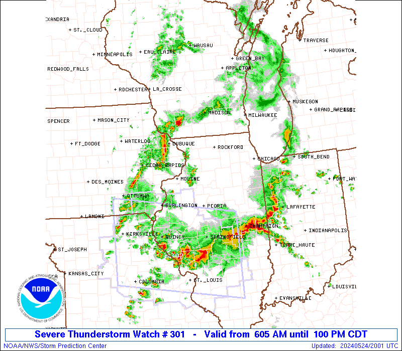
SUMMARY...A well-organized squall line, preceded by isolated
strong-severe thunderstorms, should continue to move across Iowa and
the Mississippi River into adjoining parts of Illinois and
southwestern Wisconsin through midday. Damaging to severe gusts
should continue, along with a threat for a brief/embedded tornado or
two.
The severe thunderstorm watch area is approximately along and 70
statute miles north and south of a line from 20 miles west of Moline
IL to 55 miles east northeast of Marseilles IL. For a complete
depiction of the watch see the associated watch outline update
(WOUS64 KWNS WOU1).
PRECAUTIONARY/PREPAREDNESS ACTIONS...
REMEMBER...A Severe Thunderstorm Watch means conditions are
favorable for severe thunderstorms in and close to the watch area.
Persons in these areas should be on the lookout for threatening
weather conditions and listen for later statements and possible
warnings. Severe thunderstorms can and occasionally do produce
tornadoes.
&&
OTHER WATCH INFORMATION...CONTINUE...WW 300...
AVIATION...A few severe thunderstorms with hail surface and aloft to
1.5 inches. Extreme turbulence and surface wind gusts to 65 knots. A
few cumulonimbi with maximum tops to 500. Mean storm motion vector
26040.
...Edwards
   SEL1

   URGENT - IMMEDIATE BROADCAST REQUESTED
   Severe Thunderstorm Watch Number 301
   NWS Storm Prediction Center Norman OK
   605 AM CDT Fri May 24 2024

   The NWS Storm Prediction Center has issued a

   * Severe Thunderstorm Watch for portions of
     Eastern and northeastern Iowa
     Northern Illinois
     Southwestern Wisconsin
     Lake Michigan

   * Effective this Friday morning and afternoon from 605 AM until
     100 PM CDT.

   * Primary threats include...
     Scattered damaging winds likely with isolated significant gusts
       to 75 mph possible
     Isolated large hail events to 1.5 inches in diameter possible
     A tornado or two possible

   SUMMARY...A well-organized squall line, preceded by isolated
   strong-severe thunderstorms, should continue to move across Iowa and
   the Mississippi River into adjoining parts of Illinois and
   southwestern Wisconsin through midday.  Damaging to severe gusts
   should continue, along with a threat for a brief/embedded tornado or
   two.

   The severe thunderstorm watch area is approximately along and 70
   statute miles north and south of a line from 20 miles west of Moline
   IL to 55 miles east northeast of Marseilles IL. For a complete
   depiction of the watch see the associated watch outline update
   (WOUS64 KWNS WOU1).

   PRECAUTIONARY/PREPAREDNESS ACTIONS...

   REMEMBER...A Severe Thunderstorm Watch means conditions are
   favorable for severe thunderstorms in and close to the watch area.
   Persons in these areas should be on the lookout for threatening
   weather conditions and listen for later statements and possible
   warnings. Severe thunderstorms can and occasionally do produce
   tornadoes.

   &&

   OTHER WATCH INFORMATION...CONTINUE...WW 300...

   AVIATION...A few severe thunderstorms with hail surface and aloft to
   1.5 inches. Extreme turbulence and surface wind gusts to 65 knots. A
   few cumulonimbi with maximum tops to 500. Mean storm motion vector
   26040.

   ...Edwards
 Note:
The Aviation Watch (SAW) product is an approximation to the watch area.
The actual watch is depicted by the shaded areas.
Note:
The Aviation Watch (SAW) product is an approximation to the watch area.
The actual watch is depicted by the shaded areas.
   SAW1
   WW 301 SEVERE TSTM IA IL WI LM 241105Z - 241800Z
   AXIS..70 STATUTE MILES NORTH AND SOUTH OF LINE..
   20W MLI/MOLINE IL/ - 55ENE MMO/MARSEILLES IL/
   ..AVIATION COORDS.. 60NM N/S /33E IOW - 21SSE ORD/
   HAIL SURFACE AND ALOFT..1.5 INCHES. WIND GUSTS..65 KNOTS.
   MAX TOPS TO 500. MEAN STORM MOTION VECTOR 26040.

   LAT...LON 42469089 42688770 40668770 40439089

   THIS IS AN APPROXIMATION TO THE WATCH AREA.  FOR A
   COMPLETE DEPICTION OF THE WATCH SEE WOUS64 KWNS
   FOR WOU1.
Watch 301 Status Report Messages:
STATUS REPORT #3 ON WW 301
VALID 241600Z - 241700Z
SEVERE WEATHER THREAT CONTINUES RIGHT OF A LINE FROM 15 SE BRL TO
35 NNW BMI TO 30 N MMO TO 15 E JVL.
..SMITH..05/24/24
ATTN...WFO...ARX...DVN...LOT...ILX...MKX...
&&
STATUS REPORT FOR WS 301
SEVERE WEATHER THREAT CONTINUES FOR THE FOLLOWING AREAS
ILC007-031-037-043-053-057-063-067-075-089-091-093-095-097-099-
105-109-111-113-143-179-197-203-241700-
IL
. ILLINOIS COUNTIES INCLUDED ARE
BOONE COOK DE KALB
DUPAGE FORD FULTON
GRUNDY HANCOCK IROQUOIS
KANE KANKAKEE KENDALL
KNOX LAKE LA SALLE
LIVINGSTON MCDONOUGH MCHENRY
MCLEAN PEORIA TAZEWELL
WILL WOODFORD
$$
WIC059-079-089-101-127-131-133-241700-
WI
. WISCONSIN COUNTIES INCLUDED ARE
KENOSHA MILWAUKEE OZAUKEE
RACINE WALWORTH WASHINGTON
WAUKESHA
$$
LMZ644-645-646-740-741-742-241700-
CW
. ADJACENT COASTAL WATERS INCLUDED ARE
PORT WASHINGTON TO NORTH POINT LIGHT WI
NORTH POINT LIGHT TO WIND POINT WI
WIND POINT WI TO WINTHROP HARBOR IL
WINTHROP HARBOR TO WILMETTE HARBOR IL
WILMETTE HARBOR TO NORTHERLY ISLAND IL
NORTHERLY ISLAND TO CALUMET HARBOR IL
$$
THE WATCH STATUS MESSAGE IS FOR GUIDANCE PURPOSES ONLY. PLEASE
REFER TO WATCH COUNTY NOTIFICATION STATEMENTS FOR OFFICIAL
INFORMATION ON COUNTIES...INDEPENDENT CITIES AND MARINE ZONES
CLEARED FROM SEVERE THUNDERSTORM AND TORNADO WATCHES.
$$
STATUS REPORT #2 ON WW 301
VALID 241445Z - 241540Z
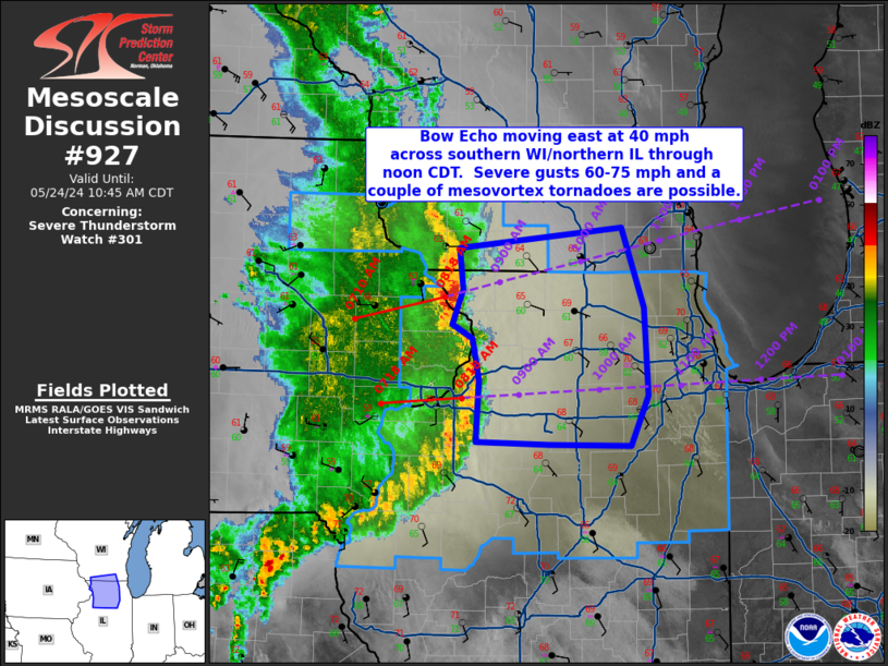
SEVERE WEATHER THREAT CONTINUES RIGHT OF A LINE FROM 35 SE BRL TO
45 N PIA TO 25 W JVL.
FOR ADDITIONAL INFORMATION SEE MESOSCALE DISCUSSION 927
..SMITH..05/24/24
ATTN...WFO...ARX...DVN...LOT...ILX...MKX...
&&
STATUS REPORT FOR WS 301
SEVERE WEATHER THREAT CONTINUES FOR THE FOLLOWING AREAS
ILC007-011-031-037-043-053-057-063-067-075-089-091-093-097-099-
103-105-109-111-113-123-141-143-155-175-177-179-197-201-203-
241540-
IL
. ILLINOIS COUNTIES INCLUDED ARE
BOONE BUREAU COOK
DE KALB DUPAGE FORD
FULTON GRUNDY HANCOCK
IROQUOIS KANE KANKAKEE
KENDALL LAKE LA SALLE
LEE LIVINGSTON MCDONOUGH
MCHENRY MCLEAN MARSHALL
OGLE PEORIA PUTNAM
STARK STEPHENSON TAZEWELL
WILL WINNEBAGO WOODFORD
$$
WIC045-059-101-105-127-241540-
WI
. WISCONSIN COUNTIES INCLUDED ARE
GREEN KENOSHA RACINE
ROCK WALWORTH
$$
LMZ740-741-742-241540-
CW
. ADJACENT COASTAL WATERS INCLUDED ARE
WINTHROP HARBOR TO WILMETTE HARBOR IL
WILMETTE HARBOR TO NORTHERLY ISLAND IL
NORTHERLY ISLAND TO CALUMET HARBOR IL
$$
THE WATCH STATUS MESSAGE IS FOR GUIDANCE PURPOSES ONLY. PLEASE
REFER TO WATCH COUNTY NOTIFICATION STATEMENTS FOR OFFICIAL
INFORMATION ON COUNTIES...INDEPENDENT CITIES AND MARINE ZONES
CLEARED FROM SEVERE THUNDERSTORM AND TORNADO WATCHES.
$$
STATUS REPORT #1 ON WW 301
VALID 241300Z - 241440Z
THE SEVERE WEATHER THREAT CONTINUES ACROSS THE ENTIRE WATCH AREA.
..GOSS..05/24/24
ATTN...WFO...ARX...DVN...LOT...ILX...MKX...
&&
STATUS REPORT FOR WS 301
SEVERE WEATHER THREAT CONTINUES FOR THE FOLLOWING AREAS
ILC007-011-015-031-037-043-053-057-063-067-071-073-075-085-089-
091-093-095-097-099-103-105-109-111-113-123-131-141-143-155-161-
175-177-179-187-195-197-201-203-241440-
IL
. ILLINOIS COUNTIES INCLUDED ARE
BOONE BUREAU CARROLL
COOK DE KALB DUPAGE
FORD FULTON GRUNDY
HANCOCK HENDERSON HENRY
IROQUOIS JO DAVIESS KANE
KANKAKEE KENDALL KNOX
LAKE LA SALLE LEE
LIVINGSTON MCDONOUGH MCHENRY
MCLEAN MARSHALL MERCER
OGLE PEORIA PUTNAM
ROCK ISLAND STARK STEPHENSON
TAZEWELL WARREN WHITESIDE
WILL WINNEBAGO WOODFORD
$$
IAC045-097-163-241440-
IA
. IOWA COUNTIES INCLUDED ARE
CLINTON JACKSON SCOTT
$$
WIC043-045-049-065-241440-
WI
. WISCONSIN COUNTIES INCLUDED ARE
GRANT GREEN IOWA
LAFAYETTE
$$
LMZ740-741-742-241440-
CW
. ADJACENT COASTAL WATERS INCLUDED ARE
WINTHROP HARBOR TO WILMETTE HARBOR IL
WILMETTE HARBOR TO NORTHERLY ISLAND IL
NORTHERLY ISLAND TO CALUMET HARBOR IL
$$
THE WATCH STATUS MESSAGE IS FOR GUIDANCE PURPOSES ONLY. PLEASE
REFER TO WATCH COUNTY NOTIFICATION STATEMENTS FOR OFFICIAL
INFORMATION ON COUNTIES...INDEPENDENT CITIES AND MARINE ZONES
CLEARED FROM SEVERE THUNDERSTORM AND TORNADO WATCHES.
$$
Note:
Click for Complete Product Text.
Tornadoes
Probability of 2 or more tornadoes
|
Low (20%)
|
Probability of 1 or more strong (EF2-EF5) tornadoes
|
Low (5%)
|
Wind
Probability of 10 or more severe wind events
|
Mod (60%)
|
Probability of 1 or more wind events > 65 knots
|
Mod (30%)
|
Hail
Probability of 10 or more severe hail events
|
Low (20%)
|
Probability of 1 or more hailstones > 2 inches
|
Low (10%)
|
Combined Severe Hail/Wind
Probability of 6 or more combined severe hail/wind events
|
High (80%)
|
For each watch, probabilities for particular events inside the watch
(listed above in each table) are determined by the issuing forecaster.
The "Low" category contains probability values ranging from less than 2%
to 20% (EF2-EF5 tornadoes), less than 5% to 20% (all other probabilities),
"Moderate" from 30% to 60%, and "High" from 70% to greater than 95%.
High values are bolded and lighter in color to provide awareness of
an increased threat for a particular event.


 @NWSSPC