|
| Mesoscale Discussion 927 |
|
< Previous MD Next MD >
|
|
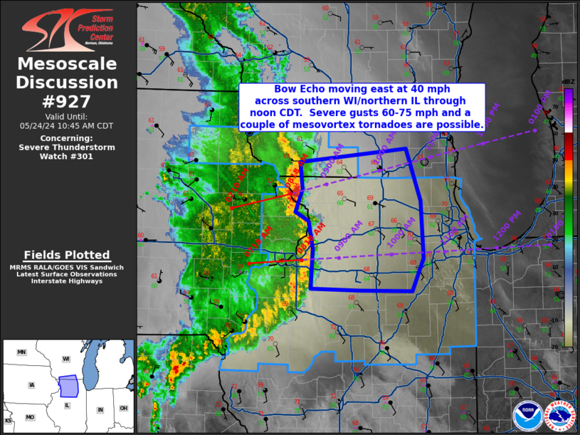
   Mesoscale Discussion 0927
   NWS Storm Prediction Center Norman OK
   0844 AM CDT Fri May 24 2024

   Areas affected...far southern WI...northern IL

   Concerning...Severe Thunderstorm Watch 301...

   Valid 241344Z - 241545Z

   The severe weather threat for Severe Thunderstorm Watch 301
   continues.

   SUMMARY...A severe bow echo will continue moving east at 40 mph
   across far southern WI and northern IL through 1030 am CDT.  Severe
   gusts 60-75 mph are likely with the more intense bowing segments of
   the squall line and a couple of mesovortex tornadoes are possible.

   DISCUSSION...A long-lived bow echo is currently moving across the MS
   River this morning.  The airmass downstream of the squall line
   continues to destabilize despite an anvil-level cloud shield
   spreading east.  Surface analysis indicates a warm front is
   advancing northward from north-central IN through far northeast IL
   and into southern WI.  South of the boundary, surface dewpoints are
   rising into the lower to mid 60s deg F and temperatures are in the
   upper 60s.  Further heating will likely result in temperatures
   rising into the mid-upper 60s over far southern WI and into the
   low-mid 70s across northern IL prior to squall line passage.

   Water-vapor imagery shows a progressive negatively tilted mid-level
   shortwave trough/mid-level low over the Upper Midwest.  The very
   mature character of the Rear Inflow Jet sampled via the Des Moines
   and Davenport WSR-88Ds VADs suggest the strongly dynamic nature of
   the squall line and destabilizing boundary layer ahead of it, will
   combine to support a likely continuation of severe-gust risk into
   the greater Chicago metro during the 1030am to 1200pm timeframe.
   Severe gusts primarily in the 60-75 mph are likely in the next 1-2
   hours as this activity moves east across northern IL/far southern
   WI.  A couple of mesovortices capable of severe gusts and/or brief
   tornadoes are possible.

   ..Smith.. 05/24/2024

   ...Please see www.spc.noaa.gov for graphic product...

   ATTN...WFO...LOT...ILX...MKX...DVN...

   LAT...LON   42689028 42848860 42218837 41538832 41158851 41158935
               41189010 41659008 41989014 42099036 42359024 42689028
|
|
Top/All Mesoscale Discussions/Forecast Products/Home
|
|


 @NWSSPC