Note:
The expiration time in the watch graphic is amended if the watch is
replaced, cancelled or extended.
Note:
Note:
The expiration time in the watch graphic is amended if the watch is
replaced, cancelled or extended.
Note: Click for
Watch Status Reports.
SEL9
URGENT - IMMEDIATE BROADCAST REQUESTED
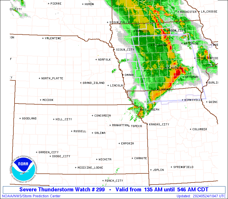
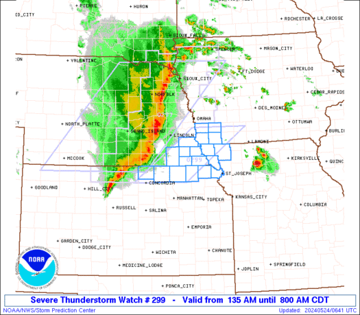
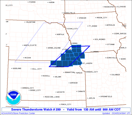
Severe Thunderstorm Watch Number 299
NWS Storm Prediction Center Norman OK
135 AM CDT Fri May 24 2024
The NWS Storm Prediction Center has issued a
* Severe Thunderstorm Watch for portions of
Southwestern Iowa
Northeastern Kansas
Northwestern Missouri
Southeastern Nebraska
* Effective this Friday morning from 135 AM until 800 AM CDT.
* Primary threats include...
Scattered damaging winds and isolated significant gusts to 80
mph possible
Isolated large hail events to 1.5 inches in diameter possible
A tornado or two possible
SUMMARY...The southern part of a well-organized and sporadically
severe squall line should cross the watch area through the pre-dawn
hours. Severe-gust swaths and downbursts are the main concern, with
a brief/embedded tornado and/or isolated severe hail also possible.
The severe thunderstorm watch area is approximately along and 50
statute miles east and west of a line from 55 miles south southwest
of Beatrice NE to 30 miles northeast of Shenandoah IA. For a
complete depiction of the watch see the associated watch outline
update (WOUS64 KWNS WOU9).
PRECAUTIONARY/PREPAREDNESS ACTIONS...
REMEMBER...A Severe Thunderstorm Watch means conditions are
favorable for severe thunderstorms in and close to the watch area.
Persons in these areas should be on the lookout for threatening
weather conditions and listen for later statements and possible
warnings. Severe thunderstorms can and occasionally do produce
tornadoes.
&&
OTHER WATCH INFORMATION...CONTINUE...WW 297...WW 298...
AVIATION...A few severe thunderstorms with hail surface and aloft to
1.5 inches. Extreme turbulence and surface wind gusts to 70 knots. A
few cumulonimbi with maximum tops to 550. Mean storm motion vector
27040.
...Edwards
   SEL9

   URGENT - IMMEDIATE BROADCAST REQUESTED
   Severe Thunderstorm Watch Number 299
   NWS Storm Prediction Center Norman OK
   135 AM CDT Fri May 24 2024

   The NWS Storm Prediction Center has issued a

   * Severe Thunderstorm Watch for portions of
     Southwestern Iowa
     Northeastern Kansas
     Northwestern Missouri
     Southeastern Nebraska

   * Effective this Friday morning from 135 AM until 800 AM CDT.

   * Primary threats include...
     Scattered damaging winds and isolated significant gusts to 80
       mph possible
     Isolated large hail events to 1.5 inches in diameter possible
     A tornado or two possible

   SUMMARY...The southern part of a well-organized and sporadically
   severe squall line should cross the watch area through the pre-dawn
   hours.  Severe-gust swaths and downbursts are the main concern, with
   a brief/embedded tornado and/or isolated severe hail also possible.

   The severe thunderstorm watch area is approximately along and 50
   statute miles east and west of a line from 55 miles south southwest
   of Beatrice NE to 30 miles northeast of Shenandoah IA. For a
   complete depiction of the watch see the associated watch outline
   update (WOUS64 KWNS WOU9).

   PRECAUTIONARY/PREPAREDNESS ACTIONS...

   REMEMBER...A Severe Thunderstorm Watch means conditions are
   favorable for severe thunderstorms in and close to the watch area.
   Persons in these areas should be on the lookout for threatening
   weather conditions and listen for later statements and possible
   warnings. Severe thunderstorms can and occasionally do produce
   tornadoes.

   &&

   OTHER WATCH INFORMATION...CONTINUE...WW 297...WW 298...

   AVIATION...A few severe thunderstorms with hail surface and aloft to
   1.5 inches. Extreme turbulence and surface wind gusts to 70 knots. A
   few cumulonimbi with maximum tops to 550. Mean storm motion vector
   27040.

   ...Edwards
 Note:
The Aviation Watch (SAW) product is an approximation to the watch area.
The actual watch is depicted by the shaded areas.
Note:
The Aviation Watch (SAW) product is an approximation to the watch area.
The actual watch is depicted by the shaded areas.
   SAW9
   WW 299 SEVERE TSTM IA KS MO NE 240635Z - 241300Z
   AXIS..50 STATUTE MILES EAST AND WEST OF LINE..
   55SSW BIE/BEATRICE NE/ - 30NE SDA/SHENANDOAH IA/
   ..AVIATION COORDS.. 45NM E/W /43NNE SLN - 34ESE OVR/
   HAIL SURFACE AND ALOFT..1.5 INCHES. WIND GUSTS..70 KNOTS.
   MAX TOPS TO 550. MEAN STORM MOTION VECTOR 27040.

   LAT...LON 39559808 41059597 41059405 39559621

   THIS IS AN APPROXIMATION TO THE WATCH AREA.  FOR A
   COMPLETE DEPICTION OF THE WATCH SEE WOUS64 KWNS
   FOR WOU9.
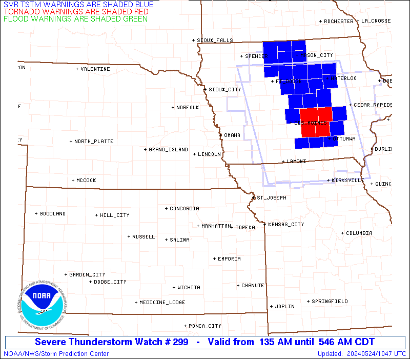
Watch 299 Status Report Messages:
STATUS REPORT #1 ON WW 299

VALID 240840Z - 240940Z

THE SEVERE WEATHER THREAT CONTINUES ACROSS THE ENTIRE WATCH AREA.

..GOSS..05/24/24

ATTN...WFO...OAX...TOP...EAX...

&&

STATUS REPORT FOR WS 299

SEVERE WEATHER THREAT CONTINUES FOR THE FOLLOWING AREAS

IAC071-129-137-145-240940-

IA
.    IOWA COUNTIES INCLUDED ARE

FREMONT 	     MILLS		 MONTGOMERY
PAGE
$$


KSC013-043-117-131-157-201-240940-

KS
.    KANSAS COUNTIES INCLUDED ARE

BROWN		     DONIPHAN		 MARSHALL
NEMAHA		     REPUBLIC		 WASHINGTON
$$


MOC005-087-147-240940-

MO
.    MISSOURI COUNTIES INCLUDED ARE

ATCHISON	     HOLT		 NODAWAY
$$


NEC067-097-127-131-133-147-240940-

NE
.    NEBRASKA COUNTIES INCLUDED ARE

GAGE		     JOHNSON		 NEMAHA
OTOE		     PAWNEE		 RICHARDSON
$$


THE WATCH STATUS MESSAGE IS FOR GUIDANCE PURPOSES ONLY.  PLEASE
REFER TO WATCH COUNTY NOTIFICATION STATEMENTS FOR OFFICIAL
INFORMATION ON COUNTIES...INDEPENDENT CITIES AND MARINE ZONES
CLEARED FROM SEVERE THUNDERSTORM AND TORNADO WATCHES.
$$
Note:
Click for Complete Product Text.
Tornadoes
Probability of 2 or more tornadoes
|
Low (20%)
|
Probability of 1 or more strong (EF2-EF5) tornadoes
|
Low (5%)
|
Wind
Probability of 10 or more severe wind events
|
Mod (50%)
|
Probability of 1 or more wind events > 65 knots
|
Mod (40%)
|
Hail
Probability of 10 or more severe hail events
|
Mod (30%)
|
Probability of 1 or more hailstones > 2 inches
|
Low (10%)
|
Combined Severe Hail/Wind
Probability of 6 or more combined severe hail/wind events
|
High (70%)
|
For each watch, probabilities for particular events inside the watch
(listed above in each table) are determined by the issuing forecaster.
The "Low" category contains probability values ranging from less than 2%
to 20% (EF2-EF5 tornadoes), less than 5% to 20% (all other probabilities),
"Moderate" from 30% to 60%, and "High" from 70% to greater than 95%.
High values are bolded and lighter in color to provide awareness of
an increased threat for a particular event.


 @NWSSPC