 Note:
The expiration time in the watch graphic is amended if the watch is
replaced, cancelled or extended.
Note:
Note:
The expiration time in the watch graphic is amended if the watch is
replaced, cancelled or extended.
Note: Click for
Watch Status Reports.
SEL8
URGENT - IMMEDIATE BROADCAST REQUESTED
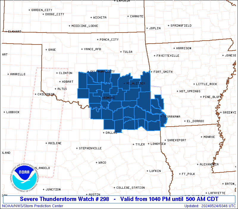
Severe Thunderstorm Watch Number 298
NWS Storm Prediction Center Norman OK
1040 PM CDT Thu May 23 2024
The NWS Storm Prediction Center has issued a
* Severe Thunderstorm Watch for portions of
Extreme southwest Arkansas
South central and southeast Oklahoma
Northeast Texas
* Effective this Thursday night and Friday morning from 1040 PM
until 500 AM CDT.
* Primary threats include...
Scattered large hail and isolated very large hail events to 2
inches in diameter possible
Isolated damaging wind gusts to 70 mph possible
SUMMARY...Slightly elevated storms will continue to increase through
the overnight hours and spread eastward near the Red River, with the
potential for both supercells with large hail up to 2 inches in
diameter, and some upscale growth into a small cluster with 60-70
mph outflow gusts.
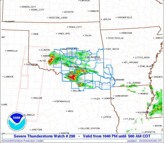
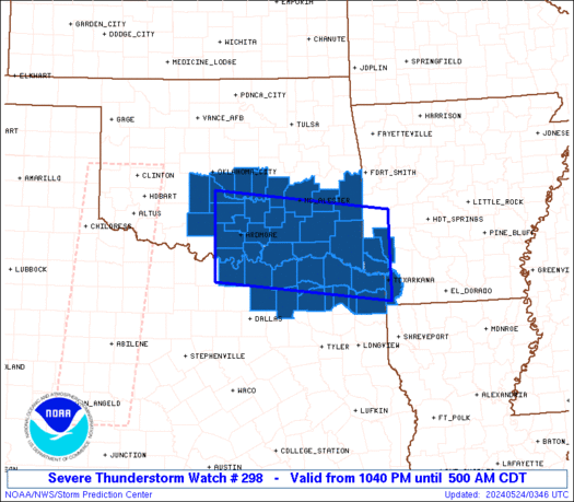
The severe thunderstorm watch area is approximately along and 55
statute miles north and south of a line from 30 miles west of
Ardmore OK to 30 miles east southeast of De Queen AR. For a complete
depiction of the watch see the associated watch outline update
(WOUS64 KWNS WOU8).
PRECAUTIONARY/PREPAREDNESS ACTIONS...
REMEMBER...A Severe Thunderstorm Watch means conditions are
favorable for severe thunderstorms in and close to the watch area.
Persons in these areas should be on the lookout for threatening
weather conditions and listen for later statements and possible
warnings. Severe thunderstorms can and occasionally do produce
tornadoes.
&&
OTHER WATCH INFORMATION...CONTINUE...WW 294...WW 295...WW 297...
AVIATION...A few severe thunderstorms with hail surface and aloft to
2 inches. Extreme turbulence and surface wind gusts to 60 knots. A
few cumulonimbi with maximum tops to 550. Mean storm motion vector
27025.
...Thompson
   SEL8

   URGENT - IMMEDIATE BROADCAST REQUESTED
   Severe Thunderstorm Watch Number 298
   NWS Storm Prediction Center Norman OK
   1040 PM CDT Thu May 23 2024

   The NWS Storm Prediction Center has issued a

   * Severe Thunderstorm Watch for portions of
     Extreme southwest Arkansas
     South central and southeast Oklahoma
     Northeast Texas

   * Effective this Thursday night and Friday morning from 1040 PM
     until 500 AM CDT.

   * Primary threats include...
     Scattered large hail and isolated very large hail events to 2
       inches in diameter possible
     Isolated damaging wind gusts to 70 mph possible

   SUMMARY...Slightly elevated storms will continue to increase through
   the overnight hours and spread eastward near the Red River, with the
   potential for both supercells with large hail up to 2 inches in
   diameter, and some upscale growth into a small cluster with 60-70
   mph outflow gusts.

   The severe thunderstorm watch area is approximately along and 55
   statute miles north and south of a line from 30 miles west of
   Ardmore OK to 30 miles east southeast of De Queen AR. For a complete
   depiction of the watch see the associated watch outline update
   (WOUS64 KWNS WOU8).

   PRECAUTIONARY/PREPAREDNESS ACTIONS...

   REMEMBER...A Severe Thunderstorm Watch means conditions are
   favorable for severe thunderstorms in and close to the watch area.
   Persons in these areas should be on the lookout for threatening
   weather conditions and listen for later statements and possible
   warnings. Severe thunderstorms can and occasionally do produce
   tornadoes.

   &&

   OTHER WATCH INFORMATION...CONTINUE...WW 294...WW 295...WW 297...

   AVIATION...A few severe thunderstorms with hail surface and aloft to
   2 inches. Extreme turbulence and surface wind gusts to 60 knots. A
   few cumulonimbi with maximum tops to 550. Mean storm motion vector
   27025.

   ...Thompson
 Note:
The Aviation Watch (SAW) product is an approximation to the watch area.
The actual watch is depicted by the shaded areas.
Note:
The Aviation Watch (SAW) product is an approximation to the watch area.
The actual watch is depicted by the shaded areas.
   SAW8
   WW 298 SEVERE TSTM AR OK TX 240340Z - 241000Z
   AXIS..55 STATUTE MILES NORTH AND SOUTH OF LINE..
   30W ADM/ARDMORE OK/ - 30ESE DEQ/DE QUEEN AR/
   ..AVIATION COORDS.. 50NM N/S /19WNW ADM - 24NNE TXK/
   HAIL SURFACE AND ALOFT..2 INCHES. WIND GUSTS..60 KNOTS.
   MAX TOPS TO 550. MEAN STORM MOTION VECTOR 27025.

   LAT...LON 35089755 34689392 33099392 33499755

   THIS IS AN APPROXIMATION TO THE WATCH AREA.  FOR A
   COMPLETE DEPICTION OF THE WATCH SEE WOUS64 KWNS
   FOR WOU8.
Watch 298 Status Report Messages:
STATUS REPORT #5 ON WW 298

VALID 240835Z - 240940Z

SEVERE WEATHER THREAT CONTINUES RIGHT OF A LINE FROM 30 SSE GYI
TO 20 ESE DUA TO 35 NNW PRX TO 30 E MLC.

..GOSS..05/24/24

ATTN...WFO...SHV...OUN...TSA...FWD...

&&

STATUS REPORT FOR WS 298

SEVERE WEATHER THREAT CONTINUES FOR THE FOLLOWING AREAS

ARC061-081-091-133-240940-

AR
.    ARKANSAS COUNTIES INCLUDED ARE

HOWARD		     LITTLE RIVER	 MILLER
SEVIER
$$


OKC023-077-079-089-121-127-240940-

OK
.    OKLAHOMA COUNTIES INCLUDED ARE

CHOCTAW 	     LATIMER		 LE FLORE
MCCURTAIN	     PITTSBURG		 PUSHMATAHA
$$


TXC037-063-067-119-147-159-223-231-277-343-387-449-240940-

TX
.    TEXAS COUNTIES INCLUDED ARE

BOWIE		     CAMP		 CASS
DELTA		     FANNIN		 FRANKLIN
HOPKINS 	     HUNT		 LAMAR
MORRIS		     RED RIVER		 TITUS
$$


THE WATCH STATUS MESSAGE IS FOR GUIDANCE PURPOSES ONLY.  PLEASE
REFER TO WATCH COUNTY NOTIFICATION STATEMENTS FOR OFFICIAL
INFORMATION ON COUNTIES...INDEPENDENT CITIES AND MARINE ZONES
CLEARED FROM SEVERE THUNDERSTORM AND TORNADO WATCHES.
$$

STATUS REPORT #4 ON WW 298

VALID 240740Z - 240840Z

SEVERE WEATHER THREAT CONTINUES RIGHT OF A LINE FROM 30 SW GYI TO
20 NW GYI TO 30 NNE DUA TO 10 NNE MLC.

..GOSS..05/24/24

ATTN...WFO...SHV...OUN...TSA...FWD...

&&

STATUS REPORT FOR WS 298

SEVERE WEATHER THREAT CONTINUES FOR THE FOLLOWING AREAS

ARC061-081-091-133-240840-

AR
.    ARKANSAS COUNTIES INCLUDED ARE

HOWARD		     LITTLE RIVER	 MILLER
SEVIER
$$


OKC005-013-023-077-079-089-121-127-240840-

OK
.    OKLAHOMA COUNTIES INCLUDED ARE

ATOKA		     BRYAN		 CHOCTAW
LATIMER 	     LE FLORE		 MCCURTAIN
PITTSBURG	     PUSHMATAHA
$$


TXC037-063-067-119-147-159-181-223-231-277-343-379-387-449-
240840-

TX
.    TEXAS COUNTIES INCLUDED ARE

BOWIE		     CAMP		 CASS
DELTA		     FANNIN		 FRANKLIN
GRAYSON 	     HOPKINS		 HUNT
LAMAR		     MORRIS		 RAINS
RED RIVER	     TITUS
$$


THE WATCH STATUS MESSAGE IS FOR GUIDANCE PURPOSES ONLY.  PLEASE
REFER TO WATCH COUNTY NOTIFICATION STATEMENTS FOR OFFICIAL
INFORMATION ON COUNTIES...INDEPENDENT CITIES AND MARINE ZONES
CLEARED FROM SEVERE THUNDERSTORM AND TORNADO WATCHES.
$$

STATUS REPORT #3 ON WW 298

VALID 240635Z - 240740Z

SEVERE WEATHER THREAT CONTINUES RIGHT OF A LINE FROM 35 N FTW TO
25 NW ADM TO 45 NNE ADM TO 30 S MKO.

..MOORE..05/24/24

ATTN...WFO...SHV...OUN...TSA...FWD...

&&

STATUS REPORT FOR WS 298

SEVERE WEATHER THREAT CONTINUES FOR THE FOLLOWING AREAS

ARC061-081-091-133-240740-

AR
.    ARKANSAS COUNTIES INCLUDED ARE

HOWARD		     LITTLE RIVER	 MILLER
SEVIER
$$


OKC005-013-019-023-029-069-077-079-085-089-095-099-121-123-127-
240740-

OK
.    OKLAHOMA COUNTIES INCLUDED ARE

ATOKA		     BRYAN		 CARTER
CHOCTAW 	     COAL		 JOHNSTON
LATIMER 	     LE FLORE		 LOVE
MCCURTAIN	     MARSHALL		 MURRAY
PITTSBURG	     PONTOTOC		 PUSHMATAHA
$$


TXC037-067-119-147-159-181-223-231-277-343-379-387-449-240740-

TX
.    TEXAS COUNTIES INCLUDED ARE

BOWIE		     CASS		 DELTA
FANNIN		     FRANKLIN		 GRAYSON
HOPKINS 	     HUNT		 LAMAR
MORRIS		     RAINS		 RED RIVER
TITUS
$$


THE WATCH STATUS MESSAGE IS FOR GUIDANCE PURPOSES ONLY.  PLEASE
REFER TO WATCH COUNTY NOTIFICATION STATEMENTS FOR OFFICIAL
INFORMATION ON COUNTIES...INDEPENDENT CITIES AND MARINE ZONES
CLEARED FROM SEVERE THUNDERSTORM AND TORNADO WATCHES.
$$

STATUS REPORT #2 ON WW 298

VALID 240545Z - 240640Z

SEVERE WEATHER THREAT CONTINUES RIGHT OF A LINE FROM 40 WSW ADM
TO 15 E CHK TO 30 WSW MKO.

..MOORE..05/24/24

ATTN...WFO...SHV...OUN...TSA...FWD...

&&

STATUS REPORT FOR WS 298

SEVERE WEATHER THREAT CONTINUES FOR THE FOLLOWING AREAS

ARC061-081-091-133-240640-

AR
.    ARKANSAS COUNTIES INCLUDED ARE

HOWARD		     LITTLE RIVER	 MILLER
SEVIER
$$


OKC005-013-019-023-029-049-063-069-077-079-085-089-095-099-121-
123-125-127-133-240640-

OK
.    OKLAHOMA COUNTIES INCLUDED ARE

ATOKA		     BRYAN		 CARTER
CHOCTAW 	     COAL		 GARVIN
HUGHES		     JOHNSTON		 LATIMER
LE FLORE	     LOVE		 MCCURTAIN
MARSHALL	     MURRAY		 PITTSBURG
PONTOTOC	     POTTAWATOMIE	 PUSHMATAHA
SEMINOLE
$$


TXC037-067-085-097-119-147-159-181-223-231-277-343-387-449-
240640-

TX
.    TEXAS COUNTIES INCLUDED ARE

BOWIE		     CASS		 COLLIN
COOKE		     DELTA		 FANNIN
FRANKLIN	     GRAYSON		 HOPKINS
HUNT		     LAMAR		 MORRIS
RED RIVER	     TITUS
$$


THE WATCH STATUS MESSAGE IS FOR GUIDANCE PURPOSES ONLY.  PLEASE
REFER TO WATCH COUNTY NOTIFICATION STATEMENTS FOR OFFICIAL
INFORMATION ON COUNTIES...INDEPENDENT CITIES AND MARINE ZONES
CLEARED FROM SEVERE THUNDERSTORM AND TORNADO WATCHES.
$$

STATUS REPORT #1 ON WW 298

VALID 240435Z - 240540Z

THE SEVERE WEATHER THREAT CONTINUES ACROSS THE ENTIRE WATCH AREA.

..MOORE..05/24/24

ATTN...WFO...SHV...OUN...TSA...FWD...

&&

STATUS REPORT FOR WS 298

SEVERE WEATHER THREAT CONTINUES FOR THE FOLLOWING AREAS

ARC061-081-091-133-240540-

AR
.    ARKANSAS COUNTIES INCLUDED ARE

HOWARD		     LITTLE RIVER	 MILLER
SEVIER
$$


OKC005-013-019-023-027-029-049-051-063-069-077-079-085-087-089-
095-099-121-123-125-127-133-137-240540-

OK
.    OKLAHOMA COUNTIES INCLUDED ARE

ATOKA		     BRYAN		 CARTER
CHOCTAW 	     CLEVELAND		 COAL
GARVIN		     GRADY		 HUGHES
JOHNSTON	     LATIMER		 LE FLORE
LOVE		     MCCLAIN		 MCCURTAIN
MARSHALL	     MURRAY		 PITTSBURG
PONTOTOC	     POTTAWATOMIE	 PUSHMATAHA
SEMINOLE	     STEPHENS
$$


TXC037-067-085-097-119-147-159-181-223-231-277-343-387-449-
240540-

TX
.    TEXAS COUNTIES INCLUDED ARE

BOWIE		     CASS		 COLLIN
COOKE		     DELTA		 FANNIN
FRANKLIN	     GRAYSON		 HOPKINS
HUNT		     LAMAR		 MORRIS
RED RIVER	     TITUS
$$


THE WATCH STATUS MESSAGE IS FOR GUIDANCE PURPOSES ONLY.  PLEASE
REFER TO WATCH COUNTY NOTIFICATION STATEMENTS FOR OFFICIAL
INFORMATION ON COUNTIES...INDEPENDENT CITIES AND MARINE ZONES
CLEARED FROM SEVERE THUNDERSTORM AND TORNADO WATCHES.
$$
Note:
Click for Complete Product Text.
Tornadoes
Probability of 2 or more tornadoes
|
Low (10%)
|
Probability of 1 or more strong (EF2-EF5) tornadoes
|
Low (<2%)
|
Wind
Probability of 10 or more severe wind events
|
Mod (30%)
|
Probability of 1 or more wind events > 65 knots
|
Low (20%)
|
Hail
Probability of 10 or more severe hail events
|
Mod (50%)
|
Probability of 1 or more hailstones > 2 inches
|
Mod (40%)
|
Combined Severe Hail/Wind
Probability of 6 or more combined severe hail/wind events
|
High (70%)
|
For each watch, probabilities for particular events inside the watch
(listed above in each table) are determined by the issuing forecaster.
The "Low" category contains probability values ranging from less than 2%
to 20% (EF2-EF5 tornadoes), less than 5% to 20% (all other probabilities),
"Moderate" from 30% to 60%, and "High" from 70% to greater than 95%.
High values are bolded and lighter in color to provide awareness of
an increased threat for a particular event.


 @NWSSPC