 Note:
The expiration time in the watch graphic is amended if the watch is
replaced, cancelled or extended.
Note:
Note:
The expiration time in the watch graphic is amended if the watch is
replaced, cancelled or extended.
Note: Click for
Watch Status Reports.
SEL4
URGENT - IMMEDIATE BROADCAST REQUESTED
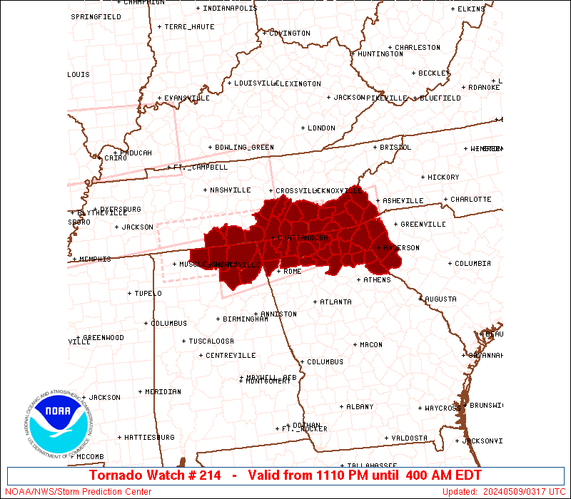
Tornado Watch Number 214
NWS Storm Prediction Center Norman OK
1110 PM EDT Wed May 8 2024
The NWS Storm Prediction Center has issued a
* Tornado Watch for portions of
Northeast Alabama
Northern Georgia
Southwest North Carolina
Western South Carolina
Southeast Tennessee
* Effective this Wednesday night and Thursday morning from 1110
PM until 400 AM EDT.
* Primary threats include...
A few tornadoes likely with a couple intense tornadoes possible
Scattered large hail and isolated very large hail events to 2
inches in diameter likely
Scattered damaging wind gusts to 70 mph likely
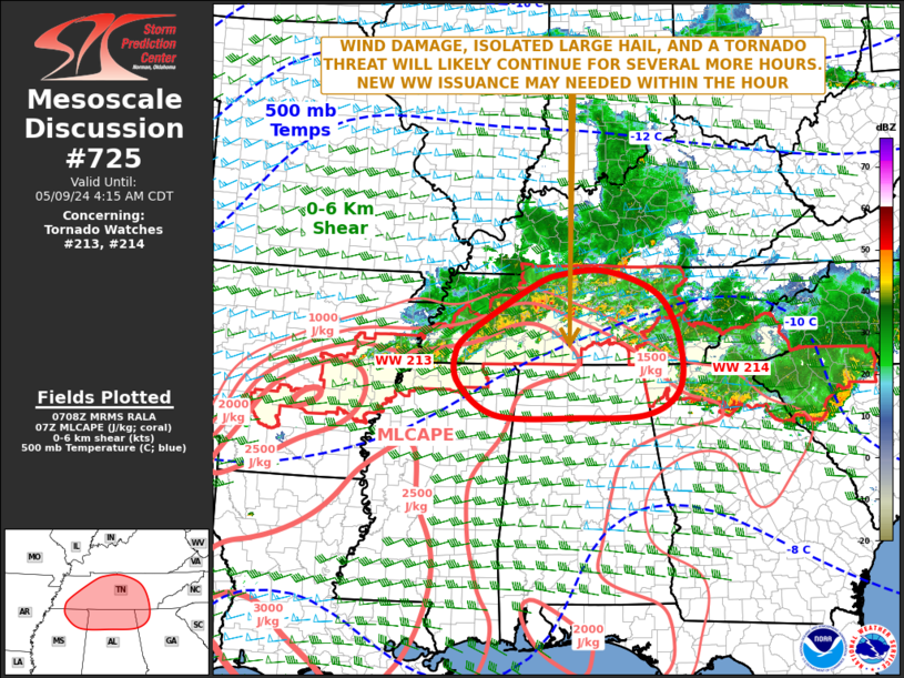
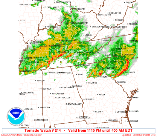
SUMMARY...Numerous severe thunderstorms continue from northern
Alabama into northern Georgia and southeast Tennessee. These storms
will track eastward overnight across the watch area, while new
isolated storms develop and move in from the west. Damaging winds
and tornadoes are possible with these storms.
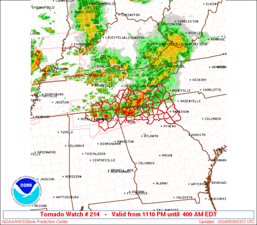
The tornado watch area is approximately along and 40 statute miles
north and south of a line from 85 miles west southwest of
Chattanooga TN to 20 miles south of Asheville NC. For a complete
depiction of the watch see the associated watch outline update
(WOUS64 KWNS WOU4).
PRECAUTIONARY/PREPAREDNESS ACTIONS...
REMEMBER...A Tornado Watch means conditions are favorable for
tornadoes and severe thunderstorms in and close to the watch
area. Persons in these areas should be on the lookout for
threatening weather conditions and listen for later statements
and possible warnings.
&&
OTHER WATCH INFORMATION...CONTINUE...WW 211...WW 212...WW 213...
AVIATION...Tornadoes and a few severe thunderstorms with hail
surface and aloft to 2 inches. Extreme turbulence and surface wind
gusts to 60 knots. A few cumulonimbi with maximum tops to 500. Mean
storm motion vector 27030.
...Hart
   SEL4

   URGENT - IMMEDIATE BROADCAST REQUESTED
   Tornado Watch Number 214
   NWS Storm Prediction Center Norman OK
   1110 PM EDT Wed May 8 2024

   The NWS Storm Prediction Center has issued a

   * Tornado Watch for portions of
     Northeast Alabama
     Northern Georgia
     Southwest North Carolina
     Western South Carolina
     Southeast Tennessee

   * Effective this Wednesday night and Thursday morning from 1110
     PM until 400 AM EDT.

   * Primary threats include...
     A few tornadoes likely with a couple intense tornadoes possible
     Scattered large hail and isolated very large hail events to 2
       inches in diameter likely
     Scattered damaging wind gusts to 70 mph likely

   SUMMARY...Numerous severe thunderstorms continue from northern
   Alabama into northern Georgia and southeast Tennessee.  These storms
   will track eastward overnight across the watch area, while new
   isolated storms develop and move in from the west.  Damaging winds
   and tornadoes are possible with these storms.

   The tornado watch area is approximately along and 40 statute miles
   north and south of a line from 85 miles west southwest of
   Chattanooga TN to 20 miles south of Asheville NC. For a complete
   depiction of the watch see the associated watch outline update
   (WOUS64 KWNS WOU4).

   PRECAUTIONARY/PREPAREDNESS ACTIONS...

   REMEMBER...A Tornado Watch means conditions are favorable for
   tornadoes and severe thunderstorms in and close to the watch
   area. Persons in these areas should be on the lookout for
   threatening weather conditions and listen for later statements
   and possible warnings.

   &&

   OTHER WATCH INFORMATION...CONTINUE...WW 211...WW 212...WW 213...

   AVIATION...Tornadoes and a few severe thunderstorms with hail
   surface and aloft to 2 inches. Extreme turbulence and surface wind
   gusts to 60 knots. A few cumulonimbi with maximum tops to 500. Mean
   storm motion vector 27030.

   ...Hart
 Note:
The Aviation Watch (SAW) product is an approximation to the watch area.
The actual watch is depicted by the shaded areas.
Note:
The Aviation Watch (SAW) product is an approximation to the watch area.
The actual watch is depicted by the shaded areas.
   SAW4
   WW 214 TORNADO AL GA NC SC TN 090310Z - 090800Z
   AXIS..40 STATUTE MILES NORTH AND SOUTH OF LINE..
   85WSW CHA/CHATTANOOGA TN/ - 20S AVL/ASHEVILLE NC/
   ..AVIATION COORDS.. 35NM N/S /45E MSL - 31WNW SPA/
   HAIL SURFACE AND ALOFT..2 INCHES. WIND GUSTS..60 KNOTS.
   MAX TOPS TO 500. MEAN STORM MOTION VECTOR 27030.

   LAT...LON 35138658 35728255 34568255 33978658

   THIS IS AN APPROXIMATION TO THE WATCH AREA.  FOR A
   COMPLETE DEPICTION OF THE WATCH SEE WOUS64 KWNS
   FOR WOU4.
Watch 214 Status Report Messages:
STATUS REPORT #4 ON WW 214

VALID 090740Z - 090840Z

THE SEVERE WEATHER THREAT CONTINUES ACROSS THE ENTIRE WATCH AREA.

..BROYLES..05/09/24

ATTN...WFO...HUN...FFC...GSP...MRX...

&&

STATUS REPORT FOR WT 214

SEVERE WEATHER THREAT CONTINUES FOR THE FOLLOWING AREAS

GAC011-047-055-083-085-105-111-119-123-129-137-139-147-187-213-
227-241-257-281-291-295-311-313-090840-

GA
.    GEORGIA COUNTIES INCLUDED ARE

BANKS		     CATOOSA		 CHATTOOGA
DADE		     DAWSON		 ELBERT
FANNIN		     FRANKLIN		 GILMER
GORDON		     HABERSHAM		 HALL
HART		     LUMPKIN		 MURRAY
PICKENS 	     RABUN		 STEPHENS
TOWNS		     UNION		 WALKER
WHITE		     WHITFIELD
$$


NCC039-043-075-087-099-113-173-175-090840-

NC
.    NORTH CAROLINA COUNTIES INCLUDED ARE

CHEROKEE	     CLAY		 GRAHAM
HAYWOOD 	     JACKSON		 MACON
SWAIN		     TRANSYLVANIA
$$


SCC001-007-021-023-045-047-059-073-077-083-087-091-090840-

SC
.    SOUTH CAROLINA COUNTIES INCLUDED ARE

ABBEVILLE	     ANDERSON		 CHEROKEE
CHESTER 	     GREENVILLE 	 GREENWOOD
LAURENS 	     OCONEE		 PICKENS
SPARTANBURG	     UNION		 YORK
$$


TNC007-011-065-107-115-121-123-139-143-153-090840-

TN
.    TENNESSEE COUNTIES INCLUDED ARE

BLEDSOE 	     BRADLEY		 HAMILTON
MCMINN		     MARION		 MEIGS
MONROE		     POLK		 RHEA
SEQUATCHIE
$$


THE WATCH STATUS MESSAGE IS FOR GUIDANCE PURPOSES ONLY.  PLEASE
REFER TO WATCH COUNTY NOTIFICATION STATEMENTS FOR OFFICIAL
INFORMATION ON COUNTIES...INDEPENDENT CITIES AND MARINE ZONES
CLEARED FROM SEVERE THUNDERSTORM AND TORNADO WATCHES.
$$

STATUS REPORT #3 ON WW 214

VALID 090635Z - 090740Z

THE SEVERE WEATHER THREAT CONTINUES ACROSS THE ENTIRE WATCH AREA.

..BROYLES..05/09/24

ATTN...WFO...HUN...FFC...GSP...MRX...

&&

STATUS REPORT FOR WT 214

SEVERE WEATHER THREAT CONTINUES FOR THE FOLLOWING AREAS

GAC011-047-055-083-085-105-111-119-123-129-137-139-147-187-213-
227-241-257-281-291-295-311-313-090740-

GA
.    GEORGIA COUNTIES INCLUDED ARE

BANKS		     CATOOSA		 CHATTOOGA
DADE		     DAWSON		 ELBERT
FANNIN		     FRANKLIN		 GILMER
GORDON		     HABERSHAM		 HALL
HART		     LUMPKIN		 MURRAY
PICKENS 	     RABUN		 STEPHENS
TOWNS		     UNION		 WALKER
WHITE		     WHITFIELD
$$


NCC039-043-075-087-099-113-173-175-090740-

NC
.    NORTH CAROLINA COUNTIES INCLUDED ARE

CHEROKEE	     CLAY		 GRAHAM
HAYWOOD 	     JACKSON		 MACON
SWAIN		     TRANSYLVANIA
$$


SCC001-007-021-023-045-047-059-073-077-083-087-091-090740-

SC
.    SOUTH CAROLINA COUNTIES INCLUDED ARE

ABBEVILLE	     ANDERSON		 CHEROKEE
CHESTER 	     GREENVILLE 	 GREENWOOD
LAURENS 	     OCONEE		 PICKENS
SPARTANBURG	     UNION		 YORK
$$


TNC007-011-065-107-115-121-123-139-143-153-090740-

TN
.    TENNESSEE COUNTIES INCLUDED ARE

BLEDSOE 	     BRADLEY		 HAMILTON
MCMINN		     MARION		 MEIGS
MONROE		     POLK		 RHEA
SEQUATCHIE
$$


THE WATCH STATUS MESSAGE IS FOR GUIDANCE PURPOSES ONLY.  PLEASE
REFER TO WATCH COUNTY NOTIFICATION STATEMENTS FOR OFFICIAL
INFORMATION ON COUNTIES...INDEPENDENT CITIES AND MARINE ZONES
CLEARED FROM SEVERE THUNDERSTORM AND TORNADO WATCHES.
$$

STATUS REPORT #2 ON WW 214

VALID 090540Z - 090640Z

THE SEVERE WEATHER THREAT CONTINUES ACROSS THE ENTIRE WATCH AREA.

..BROYLES..05/09/24

ATTN...WFO...HUN...FFC...GSP...MRX...

&&

STATUS REPORT FOR WT 214

SEVERE WEATHER THREAT CONTINUES FOR THE FOLLOWING AREAS

ALC049-071-083-089-095-090640-

AL
.    ALABAMA COUNTIES INCLUDED ARE

DEKALB		     JACKSON		 LIMESTONE
MADISON 	     MARSHALL
$$


GAC011-047-055-083-085-105-111-119-123-129-137-139-147-187-213-
227-241-257-281-291-295-311-313-090640-

GA
.    GEORGIA COUNTIES INCLUDED ARE

BANKS		     CATOOSA		 CHATTOOGA
DADE		     DAWSON		 ELBERT
FANNIN		     FRANKLIN		 GILMER
GORDON		     HABERSHAM		 HALL
HART		     LUMPKIN		 MURRAY
PICKENS 	     RABUN		 STEPHENS
TOWNS		     UNION		 WALKER
WHITE		     WHITFIELD
$$


NCC039-043-075-087-099-113-173-175-090640-

NC
.    NORTH CAROLINA COUNTIES INCLUDED ARE

CHEROKEE	     CLAY		 GRAHAM
HAYWOOD 	     JACKSON		 MACON
SWAIN		     TRANSYLVANIA
$$


SCC001-007-073-077-090640-

SC
.    SOUTH CAROLINA COUNTIES INCLUDED ARE

ABBEVILLE	     ANDERSON		 OCONEE
PICKENS
$$


TNC007-011-051-065-103-107-115-121-123-127-139-143-153-090640-

TN
.    TENNESSEE COUNTIES INCLUDED ARE

BLEDSOE 	     BRADLEY		 FRANKLIN
HAMILTON	     LINCOLN		 MCMINN
MARION		     MEIGS		 MONROE
MOORE		     POLK		 RHEA
SEQUATCHIE
$$


THE WATCH STATUS MESSAGE IS FOR GUIDANCE PURPOSES ONLY.  PLEASE
REFER TO WATCH COUNTY NOTIFICATION STATEMENTS FOR OFFICIAL
INFORMATION ON COUNTIES...INDEPENDENT CITIES AND MARINE ZONES
CLEARED FROM SEVERE THUNDERSTORM AND TORNADO WATCHES.
$$

STATUS REPORT #1 ON WW 214

VALID 090445Z - 090540Z

THE SEVERE WEATHER THREAT CONTINUES ACROSS THE ENTIRE WATCH AREA.

..GOSS..05/09/24

ATTN...WFO...HUN...FFC...GSP...MRX...

&&

STATUS REPORT FOR WT 214

SEVERE WEATHER THREAT CONTINUES FOR THE FOLLOWING AREAS

ALC049-071-083-089-095-090540-

AL
.    ALABAMA COUNTIES INCLUDED ARE

DEKALB		     JACKSON		 LIMESTONE
MADISON 	     MARSHALL
$$


GAC011-047-055-083-085-105-111-119-123-129-137-139-147-187-213-
227-241-257-281-291-295-311-313-090540-

GA
.    GEORGIA COUNTIES INCLUDED ARE

BANKS		     CATOOSA		 CHATTOOGA
DADE		     DAWSON		 ELBERT
FANNIN		     FRANKLIN		 GILMER
GORDON		     HABERSHAM		 HALL
HART		     LUMPKIN		 MURRAY
PICKENS 	     RABUN		 STEPHENS
TOWNS		     UNION		 WALKER
WHITE		     WHITFIELD
$$


NCC039-043-075-087-099-113-173-175-090540-

NC
.    NORTH CAROLINA COUNTIES INCLUDED ARE

CHEROKEE	     CLAY		 GRAHAM
HAYWOOD 	     JACKSON		 MACON
SWAIN		     TRANSYLVANIA
$$


SCC001-007-073-077-090540-

SC
.    SOUTH CAROLINA COUNTIES INCLUDED ARE

ABBEVILLE	     ANDERSON		 OCONEE
PICKENS
$$


TNC007-011-051-065-103-107-115-121-123-127-139-143-153-090540-

TN
.    TENNESSEE COUNTIES INCLUDED ARE

BLEDSOE 	     BRADLEY		 FRANKLIN
HAMILTON	     LINCOLN		 MCMINN
MARION		     MEIGS		 MONROE
MOORE		     POLK		 RHEA
SEQUATCHIE
$$


THE WATCH STATUS MESSAGE IS FOR GUIDANCE PURPOSES ONLY.  PLEASE
REFER TO WATCH COUNTY NOTIFICATION STATEMENTS FOR OFFICIAL
INFORMATION ON COUNTIES...INDEPENDENT CITIES AND MARINE ZONES
CLEARED FROM SEVERE THUNDERSTORM AND TORNADO WATCHES.
$$
Note:
Click for Complete Product Text.
Tornadoes
Probability of 2 or more tornadoes
|
High (70%)
|
Probability of 1 or more strong (EF2-EF5) tornadoes
|
Mod (40%)
|
Wind
Probability of 10 or more severe wind events
|
Mod (60%)
|
Probability of 1 or more wind events > 65 knots
|
Low (10%)
|
Hail
Probability of 10 or more severe hail events
|
Mod (60%)
|
Probability of 1 or more hailstones > 2 inches
|
Mod (60%)
|
Combined Severe Hail/Wind
Probability of 6 or more combined severe hail/wind events
|
High (>95%)
|
For each watch, probabilities for particular events inside the watch
(listed above in each table) are determined by the issuing forecaster.
The "Low" category contains probability values ranging from less than 2%
to 20% (EF2-EF5 tornadoes), less than 5% to 20% (all other probabilities),
"Moderate" from 30% to 60%, and "High" from 70% to greater than 95%.
High values are bolded and lighter in color to provide awareness of
an increased threat for a particular event.


 @NWSSPC