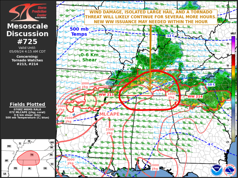
   Mesoscale Discussion 0725
   NWS Storm Prediction Center Norman OK
   0210 AM CDT Thu May 09 2024

   Areas affected...Tennessee...Northeast Mississippi...Northern
   Alabama...Far Northwest Georgia

   Concerning...Tornado Watch 213...214...

   Valid 090710Z - 090915Z

   The severe weather threat for Tornado Watch 213, 214 continues.

   SUMMARY...A threat for wind damage, isolated large hail and a few
   tornadoes will continue across western and middle Tennessee over the
   next couple of hours. The threats are expected to spread into parts
   of northeast Mississippi, northern Alabama and far northwest
   Georgia. A short-term extension or new weather watch issuance will
   be needed as the expiration of WW 213 approaches at 08Z.

   DISCUSSION...The latest hi-resolution radar imagery from Nashville,
   TN shows a large MCS with numerous severe storms, located across the
   Tennessee Valley. An undisturbed airmass is currently evident from
   southern middle Tennessee southward into the northern Gulf Coast
   states, where the RAP is analyzing MLCAPE in the 1500 to 2500 J/kg
   range. The Huntsville, AL WSR-88D VWP has 0-6 km shear near 40
   knots, with 0-3 km storm-relative helicity of 300 m2/s2. This will
   support a tornado threat, with discrete supercells that remain out
   ahead, or with the more intense cells embedded within the MCS.
   Supercells could also be associated with an isolated large-hail
   threat. A wind damage threat will also be likely, especially with
   bowing line segments.

   ..Broyles.. 05/09/2024

   ...Please see www.spc.noaa.gov for graphic product...

   ATTN...WFO...MRX...FFC...OHX...BMX...HUN...MEG...

   LAT...LON   34158549 34098688 34138854 34648930 35128939 35528908
               36288783 36508719 36548627 36168525 35408482 34578483
               34158549
|


 @NWSSPC