Note:
The expiration time in the watch graphic is amended if the watch is
replaced, cancelled or extended.
Note:
Note:
The expiration time in the watch graphic is amended if the watch is
replaced, cancelled or extended.
Note: Click for
Watch Status Reports.
SEL2
URGENT - IMMEDIATE BROADCAST REQUESTED
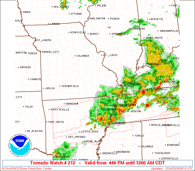
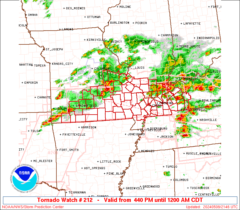
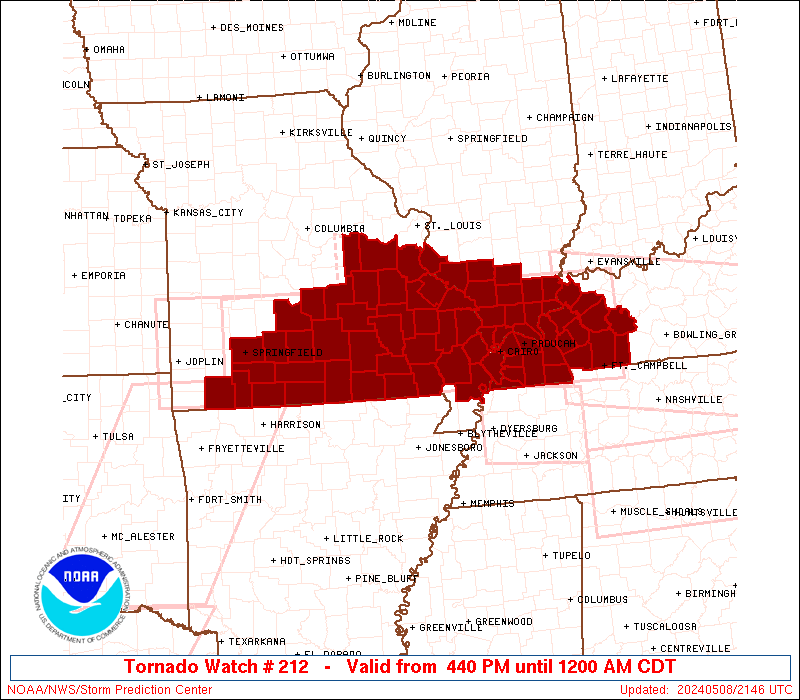
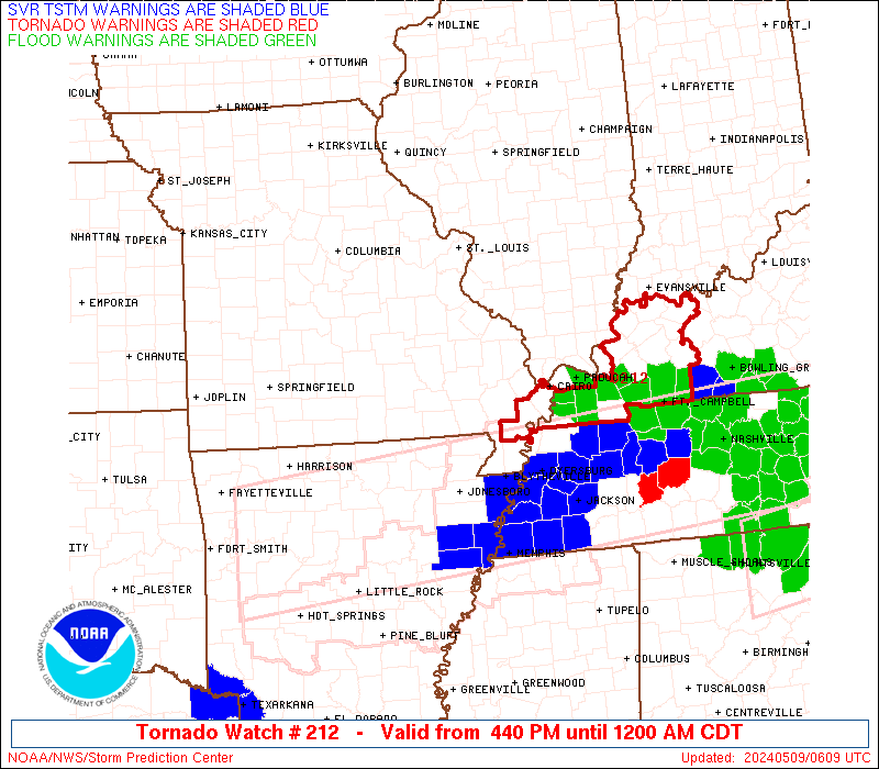
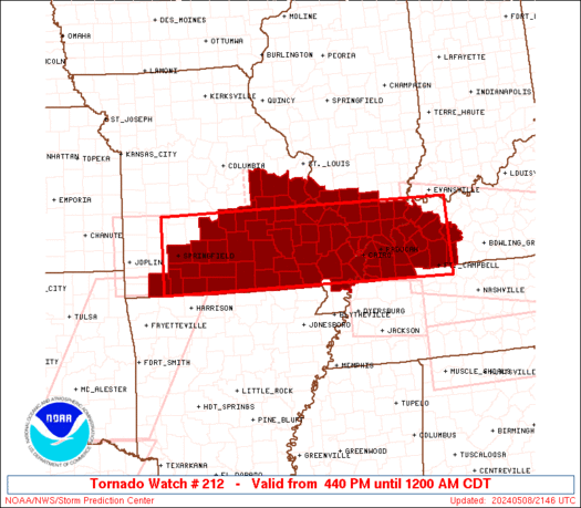
Tornado Watch Number 212
NWS Storm Prediction Center Norman OK
440 PM CDT Wed May 8 2024
The NWS Storm Prediction Center has issued a
* Tornado Watch for portions of
Southern Illinois
Western Kentucky
Southern Missouri
* Effective this Wednesday afternoon from 440 PM until Midnight
CDT.
* Primary threats include...
A few tornadoes and a couple intense tornadoes likely
Widespread large hail and scattered very large hail events to
2.5 inches in diameter likely
Widespread damaging winds and isolated significant gusts to 75
mph likely
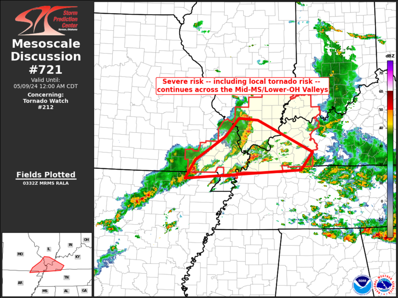
SUMMARY...Multiple rounds of severe thunderstorms will affect the
watch area through the afternoon and evening, posing a risk of large
hail and damaging winds. A few tornadoes are also expected.
The tornado watch area is approximately along and 50 statute miles
north and south of a line from 20 miles west of Springfield MO to 40
miles north northeast of Fort Campbell KY. For a complete depiction
of the watch see the associated watch outline update (WOUS64 KWNS
WOU2).
PRECAUTIONARY/PREPAREDNESS ACTIONS...
REMEMBER...A Tornado Watch means conditions are favorable for
tornadoes and severe thunderstorms in and close to the watch
area. Persons in these areas should be on the lookout for
threatening weather conditions and listen for later statements
and possible warnings.
&&
OTHER WATCH INFORMATION...CONTINUE...WW 204...WW 205...WW
206...WW 207...WW 208...WW 209...WW 210...WW 211...
AVIATION...Tornadoes and a few severe thunderstorms with hail
surface and aloft to 2.5 inches. Extreme turbulence and surface wind
gusts to 65 knots. A few cumulonimbi with maximum tops to 500. Mean
storm motion vector 26035.
...Hart
   SEL2

   URGENT - IMMEDIATE BROADCAST REQUESTED
   Tornado Watch Number 212
   NWS Storm Prediction Center Norman OK
   440 PM CDT Wed May 8 2024

   The NWS Storm Prediction Center has issued a

   * Tornado Watch for portions of
     Southern Illinois
     Western Kentucky
     Southern Missouri

   * Effective this Wednesday afternoon from 440 PM until Midnight
     CDT.

   * Primary threats include...
     A few tornadoes and a couple intense tornadoes likely
     Widespread large hail and scattered very large hail events to
       2.5 inches in diameter likely
     Widespread damaging winds and isolated significant gusts to 75
       mph likely

   SUMMARY...Multiple rounds of severe thunderstorms will affect the
   watch area through the afternoon and evening, posing a risk of large
   hail and damaging winds.  A few tornadoes are also expected.

   The tornado watch area is approximately along and 50 statute miles
   north and south of a line from 20 miles west of Springfield MO to 40
   miles north northeast of Fort Campbell KY. For a complete depiction
   of the watch see the associated watch outline update (WOUS64 KWNS
   WOU2).

   PRECAUTIONARY/PREPAREDNESS ACTIONS...

   REMEMBER...A Tornado Watch means conditions are favorable for
   tornadoes and severe thunderstorms in and close to the watch
   area. Persons in these areas should be on the lookout for
   threatening weather conditions and listen for later statements
   and possible warnings.

   &&

   OTHER WATCH INFORMATION...CONTINUE...WW 204...WW 205...WW
   206...WW 207...WW 208...WW 209...WW 210...WW 211...

   AVIATION...Tornadoes and a few severe thunderstorms with hail
   surface and aloft to 2.5 inches. Extreme turbulence and surface wind
   gusts to 65 knots. A few cumulonimbi with maximum tops to 500. Mean
   storm motion vector 26035.

   ...Hart
 Note:
The Aviation Watch (SAW) product is an approximation to the watch area.
The actual watch is depicted by the shaded areas.
Note:
The Aviation Watch (SAW) product is an approximation to the watch area.
The actual watch is depicted by the shaded areas.
SAW2
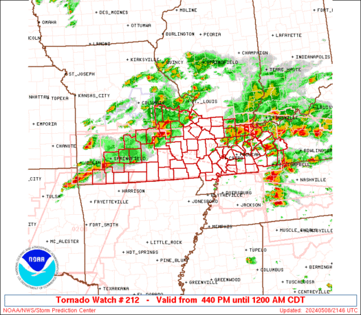
WW 212 TORNADO IL KY MO 082140Z - 090500Z
AXIS..50 STATUTE MILES NORTH AND SOUTH OF LINE..
20W SGF/SPRINGFIELD MO/ - 40NNE HOP/FORT CAMPBELL KY/
..AVIATION COORDS.. 45NM N/S /21WSW SGF - 40WNW BWG/
HAIL SURFACE AND ALOFT..2.5 INCHES. WIND GUSTS..65 KNOTS.
MAX TOPS TO 500. MEAN STORM MOTION VECTOR 26035.
LAT...LON 37939374 37938720 36488720 36509374
THIS IS AN APPROXIMATION TO THE WATCH AREA. FOR A
COMPLETE DEPICTION OF THE WATCH SEE WOUS64 KWNS
FOR WOU2.
Watch 212 Status Report Messages:
STATUS REPORT #6 ON WW 212

VALID 090440Z - 090540Z

SEVERE WEATHER THREAT CONTINUES RIGHT OF A LINE FROM 20 SW POF TO
25 SE CGI TO 20 NNE PAH TO 30 SE MVN.

..GOSS..05/09/24

ATTN...WFO...PAH...LSX...SGF...

&&

STATUS REPORT FOR WT 212

SEVERE WEATHER THREAT CONTINUES FOR THE FOLLOWING AREAS

ILC047-059-065-069-127-165-185-191-193-090540-

IL
.    ILLINOIS COUNTIES INCLUDED ARE

EDWARDS 	     GALLATIN		 HAMILTON
HARDIN		     MASSAC		 SALINE
WABASH		     WAYNE		 WHITE
$$


INC051-125-129-147-163-173-090540-

IN
.    INDIANA COUNTIES INCLUDED ARE

GIBSON		     PIKE		 POSEY
SPENCER 	     VANDERBURGH	 WARRICK
$$


KYC007-033-035-039-047-055-059-075-083-101-105-107-139-143-145-
149-157-177-219-221-225-233-090540-

KY
.    KENTUCKY COUNTIES INCLUDED ARE

BALLARD 	     CALDWELL		 CALLOWAY
CARLISLE	     CHRISTIAN		 CRITTENDEN
DAVIESS 	     FULTON		 GRAVES
HENDERSON	     HICKMAN		 HOPKINS
LIVINGSTON	     LYON		 MCCRACKEN
MCLEAN		     MARSHALL		 MUHLENBERG
TODD		     TRIGG		 UNION
WEBSTER
$$


MOC133-143-207-090540-

MO
.    MISSOURI COUNTIES INCLUDED ARE

MISSISSIPPI	     NEW MADRID 	 STODDARD
$$


THE WATCH STATUS MESSAGE IS FOR GUIDANCE PURPOSES ONLY.  PLEASE
REFER TO WATCH COUNTY NOTIFICATION STATEMENTS FOR OFFICIAL
INFORMATION ON COUNTIES...INDEPENDENT CITIES AND MARINE ZONES
CLEARED FROM SEVERE THUNDERSTORM AND TORNADO WATCHES.
$$

STATUS REPORT #5 ON WW 212

VALID 090140Z - 090240Z

SEVERE WEATHER THREAT CONTINUES RIGHT OF A LINE FROM 10 N HRO TO
35 N FLP TO 20 NNW UNO TO 45 NNE UNO TO 35 WSW FAM TO 25 NE FAM.

..BENTLEY..05/09/24

ATTN...WFO...PAH...LSX...SGF...

&&

STATUS REPORT FOR WT 212

SEVERE WEATHER THREAT CONTINUES FOR THE FOLLOWING AREAS

ILC003-047-059-065-069-077-087-127-151-153-165-181-185-193-199-
090240-

IL
.    ILLINOIS COUNTIES INCLUDED ARE

ALEXANDER	     EDWARDS		 GALLATIN
HAMILTON	     HARDIN		 JACKSON
JOHNSON 	     MASSAC		 POPE
PULASKI 	     SALINE		 UNION
WABASH		     WHITE		 WILLIAMSON
$$


INC051-125-129-147-163-173-090240-

IN
.    INDIANA COUNTIES INCLUDED ARE

GIBSON		     PIKE		 POSEY
SPENCER 	     VANDERBURGH	 WARRICK
$$


KYC007-033-035-039-047-055-059-075-083-101-105-107-139-143-145-
149-157-177-219-221-225-233-090240-

KY
.    KENTUCKY COUNTIES INCLUDED ARE

BALLARD 	     CALDWELL		 CALLOWAY
CARLISLE	     CHRISTIAN		 CRITTENDEN
DAVIESS 	     FULTON		 GRAVES
HENDERSON	     HICKMAN		 HOPKINS
LIVINGSTON	     LYON		 MCCRACKEN
MCLEAN		     MARSHALL		 MUHLENBERG
TODD		     TRIGG		 UNION
WEBSTER
$$


MOC017-023-031-035-091-093-123-133-143-149-153-157-179-181-201-
203-207-223-090240-

MO
.    MISSOURI COUNTIES INCLUDED ARE

BOLLINGER	     BUTLER		 CAPE GIRARDEAU
CARTER		     HOWELL		 IRON
MADISON 	     MISSISSIPPI	 NEW MADRID
OREGON		     OZARK		 PERRY
REYNOLDS	     RIPLEY		 SCOTT
SHANNON 	     STODDARD		 WAYNE
$$


THE WATCH STATUS MESSAGE IS FOR GUIDANCE PURPOSES ONLY.  PLEASE
REFER TO WATCH COUNTY NOTIFICATION STATEMENTS FOR OFFICIAL
INFORMATION ON COUNTIES...INDEPENDENT CITIES AND MARINE ZONES
CLEARED FROM SEVERE THUNDERSTORM AND TORNADO WATCHES.
$$

STATUS REPORT #4 ON WW 212

VALID 090110Z - 090240Z

SEVERE WEATHER THREAT CONTINUES RIGHT OF A LINE FROM 25 NW HRO TO
40 NNW FLP TO 25 NNW UNO TO 35 SE TBN TO 25 W FAM TO 25 SSW BLV.

..BENTLEY..05/09/24

ATTN...WFO...PAH...LSX...SGF...

&&

STATUS REPORT FOR WT 212

SEVERE WEATHER THREAT CONTINUES FOR THE FOLLOWING AREAS

ILC003-047-055-059-065-069-077-081-087-127-145-151-153-165-181-
185-191-193-199-090240-

IL
.    ILLINOIS COUNTIES INCLUDED ARE

ALEXANDER	     EDWARDS		 FRANKLIN
GALLATIN	     HAMILTON		 HARDIN
JACKSON 	     JEFFERSON		 JOHNSON
MASSAC		     PERRY		 POPE
PULASKI 	     SALINE		 UNION
WABASH		     WAYNE		 WHITE
WILLIAMSON
$$


INC051-125-129-147-163-173-090240-

IN
.    INDIANA COUNTIES INCLUDED ARE

GIBSON		     PIKE		 POSEY
SPENCER 	     VANDERBURGH	 WARRICK
$$


KYC007-033-035-039-047-055-059-075-083-101-105-107-139-143-145-
149-157-177-219-221-225-233-090240-

KY
.    KENTUCKY COUNTIES INCLUDED ARE

BALLARD 	     CALDWELL		 CALLOWAY
CARLISLE	     CHRISTIAN		 CRITTENDEN
DAVIESS 	     FULTON		 GRAVES
HENDERSON	     HICKMAN		 HOPKINS
LIVINGSTON	     LYON		 MCCRACKEN
MCLEAN		     MARSHALL		 MUHLENBERG
TODD		     TRIGG		 UNION
WEBSTER
$$


MOC017-023-031-035-065-067-091-093-123-133-143-149-153-157-179-
181-201-203-207-213-223-090240-

MO
.    MISSOURI COUNTIES INCLUDED ARE

BOLLINGER	     BUTLER		 CAPE GIRARDEAU
CARTER		     DENT		 DOUGLAS
HOWELL		     IRON		 MADISON
MISSISSIPPI	     NEW MADRID 	 OREGON
OZARK		     PERRY		 REYNOLDS
RIPLEY		     SCOTT		 SHANNON
STODDARD	     TANEY		 WAYNE
$$


THE WATCH STATUS MESSAGE IS FOR GUIDANCE PURPOSES ONLY.  PLEASE
REFER TO WATCH COUNTY NOTIFICATION STATEMENTS FOR OFFICIAL
INFORMATION ON COUNTIES...INDEPENDENT CITIES AND MARINE ZONES
CLEARED FROM SEVERE THUNDERSTORM AND TORNADO WATCHES.
$$

STATUS REPORT #3 ON WW 212

VALID 090010Z - 090140Z

SEVERE WEATHER THREAT CONTINUES RIGHT OF A LINE FROM 20 SSE UMN
TO 25 SE SGF TO 35 SSW TBN TO 25 W FAM TO 30 SSW BLV.

..BENTLEY..05/09/24

ATTN...WFO...PAH...LSX...SGF...

&&

STATUS REPORT FOR WT 212

SEVERE WEATHER THREAT CONTINUES FOR THE FOLLOWING AREAS

ILC003-055-059-065-069-077-081-087-127-145-151-153-157-165-181-
199-090140-

IL
.    ILLINOIS COUNTIES INCLUDED ARE

ALEXANDER	     FRANKLIN		 GALLATIN
HAMILTON	     HARDIN		 JACKSON
JEFFERSON	     JOHNSON		 MASSAC
PERRY		     POPE		 PULASKI
RANDOLPH	     SALINE		 UNION
WILLIAMSON
$$


KYC007-033-035-039-047-055-075-083-105-107-139-143-145-157-177-
219-221-225-233-090140-

KY
.    KENTUCKY COUNTIES INCLUDED ARE

BALLARD 	     CALDWELL		 CALLOWAY
CARLISLE	     CHRISTIAN		 CRITTENDEN
FULTON		     GRAVES		 HICKMAN
HOPKINS 	     LIVINGSTON 	 LYON
MCCRACKEN	     MARSHALL		 MUHLENBERG
TODD		     TRIGG		 UNION
WEBSTER
$$


MOC009-017-023-031-035-043-065-067-091-093-123-133-143-149-153-
157-179-181-186-187-201-203-207-209-213-215-223-229-090140-

MO
.    MISSOURI COUNTIES INCLUDED ARE

BARRY		     BOLLINGER		 BUTLER
CAPE GIRARDEAU	     CARTER		 CHRISTIAN
DENT		     DOUGLAS		 HOWELL
IRON		     MADISON		 MISSISSIPPI
NEW MADRID	     OREGON		 OZARK
PERRY		     REYNOLDS		 RIPLEY
STE. GENEVIEVE	     ST. FRANCOIS	 SCOTT
SHANNON 	     STODDARD		 STONE
TANEY		     TEXAS		 WAYNE
WRIGHT
$$


THE WATCH STATUS MESSAGE IS FOR GUIDANCE PURPOSES ONLY.  PLEASE
REFER TO WATCH COUNTY NOTIFICATION STATEMENTS FOR OFFICIAL
INFORMATION ON COUNTIES...INDEPENDENT CITIES AND MARINE ZONES
CLEARED FROM SEVERE THUNDERSTORM AND TORNADO WATCHES.
$$

STATUS REPORT #2 ON WW 212

VALID 082330Z - 090040Z

SEVERE WEATHER THREAT CONTINUES RIGHT OF A LINE FROM 5 S UMN TO
15 SE SGF TO 30 SW TBN TO 20 SSE JEF.

..BENTLEY..05/08/24

ATTN...WFO...PAH...LSX...SGF...

&&

STATUS REPORT FOR WT 212

SEVERE WEATHER THREAT CONTINUES FOR THE FOLLOWING AREAS

ILC003-055-059-069-077-087-127-133-145-151-153-157-165-181-199-
090040-

IL
.    ILLINOIS COUNTIES INCLUDED ARE

ALEXANDER	     FRANKLIN		 GALLATIN
HARDIN		     JACKSON		 JOHNSON
MASSAC		     MONROE		 PERRY
POPE		     PULASKI		 RANDOLPH
SALINE		     UNION		 WILLIAMSON
$$


KYC007-033-035-039-047-055-075-083-105-107-139-143-145-157-177-
219-221-225-233-090040-

KY
.    KENTUCKY COUNTIES INCLUDED ARE

BALLARD 	     CALDWELL		 CALLOWAY
CARLISLE	     CHRISTIAN		 CRITTENDEN
FULTON		     GRAVES		 HICKMAN
HOPKINS 	     LIVINGSTON 	 LYON
MCCRACKEN	     MARSHALL		 MUHLENBERG
TODD		     TRIGG		 UNION
WEBSTER
$$


MOC009-017-023-031-035-043-055-065-067-071-073-091-093-099-105-
123-133-143-149-153-157-161-169-179-181-186-187-201-203-207-209-
213-215-221-223-225-229-090040-

MO
.    MISSOURI COUNTIES INCLUDED ARE

BARRY		     BOLLINGER		 BUTLER
CAPE GIRARDEAU	     CARTER		 CHRISTIAN
CRAWFORD	     DENT		 DOUGLAS
FRANKLIN	     GASCONADE		 HOWELL
IRON		     JEFFERSON		 LACLEDE
MADISON 	     MISSISSIPPI	 NEW MADRID
OREGON		     OZARK		 PERRY
PHELPS		     PULASKI		 REYNOLDS
RIPLEY		     STE. GENEVIEVE	 ST. FRANCOIS
SCOTT		     SHANNON		 STODDARD
STONE		     TANEY		 TEXAS
WASHINGTON	     WAYNE		 WEBSTER
WRIGHT
$$


THE WATCH STATUS MESSAGE IS FOR GUIDANCE PURPOSES ONLY.  PLEASE
REFER TO WATCH COUNTY NOTIFICATION STATEMENTS FOR OFFICIAL
INFORMATION ON COUNTIES...INDEPENDENT CITIES AND MARINE ZONES
CLEARED FROM SEVERE THUNDERSTORM AND TORNADO WATCHES.
$$

STATUS REPORT #1 ON WW 212

VALID 082235Z - 082340Z

THE SEVERE WEATHER THREAT CONTINUES ACROSS THE ENTIRE WATCH AREA.

..BENTLEY..05/08/24

ATTN...WFO...PAH...LSX...SGF...

&&

STATUS REPORT FOR WT 212

SEVERE WEATHER THREAT CONTINUES FOR THE FOLLOWING AREAS

ILC003-055-059-069-077-087-127-133-145-151-153-157-165-181-199-
082340-

IL
.    ILLINOIS COUNTIES INCLUDED ARE

ALEXANDER	     FRANKLIN		 GALLATIN
HARDIN		     JACKSON		 JOHNSON
MASSAC		     MONROE		 PERRY
POPE		     PULASKI		 RANDOLPH
SALINE		     UNION		 WILLIAMSON
$$


KYC007-033-035-039-047-055-075-083-105-107-139-143-145-157-177-
219-221-225-233-082340-

KY
.    KENTUCKY COUNTIES INCLUDED ARE

BALLARD 	     CALDWELL		 CALLOWAY
CARLISLE	     CHRISTIAN		 CRITTENDEN
FULTON		     GRAVES		 HICKMAN
HOPKINS 	     LIVINGSTON 	 LYON
MCCRACKEN	     MARSHALL		 MUHLENBERG
TODD		     TRIGG		 UNION
WEBSTER
$$


MOC009-017-023-031-035-043-055-065-067-071-073-077-091-093-099-
105-123-133-143-149-153-157-161-169-179-181-186-187-201-203-207-
209-213-215-221-223-225-229-082340-

MO
.    MISSOURI COUNTIES INCLUDED ARE

BARRY		     BOLLINGER		 BUTLER
CAPE GIRARDEAU	     CARTER		 CHRISTIAN
CRAWFORD	     DENT		 DOUGLAS
FRANKLIN	     GASCONADE		 GREENE
HOWELL		     IRON		 JEFFERSON
LACLEDE 	     MADISON		 MISSISSIPPI
NEW MADRID	     OREGON		 OZARK
PERRY		     PHELPS		 PULASKI
REYNOLDS	     RIPLEY		 STE. GENEVIEVE
ST. FRANCOIS	     SCOTT		 SHANNON
STODDARD	     STONE		 TANEY
TEXAS		     WASHINGTON 	 WAYNE
WEBSTER 	     WRIGHT
$$


THE WATCH STATUS MESSAGE IS FOR GUIDANCE PURPOSES ONLY.  PLEASE
REFER TO WATCH COUNTY NOTIFICATION STATEMENTS FOR OFFICIAL
INFORMATION ON COUNTIES...INDEPENDENT CITIES AND MARINE ZONES
CLEARED FROM SEVERE THUNDERSTORM AND TORNADO WATCHES.
$$
Note:
Click for Complete Product Text.
Tornadoes
Probability of 2 or more tornadoes
|
High (70%)
|
Probability of 1 or more strong (EF2-EF5) tornadoes
|
Mod (60%)
|
Wind
Probability of 10 or more severe wind events
|
High (80%)
|
Probability of 1 or more wind events > 65 knots
|
High (70%)
|
Hail
Probability of 10 or more severe hail events
|
High (80%)
|
Probability of 1 or more hailstones > 2 inches
|
High (80%)
|
Combined Severe Hail/Wind
Probability of 6 or more combined severe hail/wind events
|
High (>95%)
|
For each watch, probabilities for particular events inside the watch
(listed above in each table) are determined by the issuing forecaster.
The "Low" category contains probability values ranging from less than 2%
to 20% (EF2-EF5 tornadoes), less than 5% to 20% (all other probabilities),
"Moderate" from 30% to 60%, and "High" from 70% to greater than 95%.
High values are bolded and lighter in color to provide awareness of
an increased threat for a particular event.


 @NWSSPC