Note:
The expiration time in the watch graphic is amended if the watch is
replaced, cancelled or extended.
Note:
Note:
The expiration time in the watch graphic is amended if the watch is
replaced, cancelled or extended.
Note: Click for
Watch Status Reports.
SEL3
URGENT - IMMEDIATE BROADCAST REQUESTED
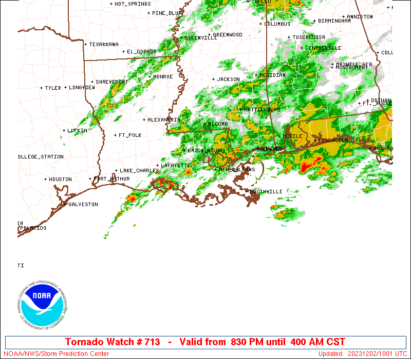
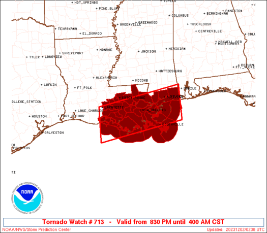
Tornado Watch Number 713
NWS Storm Prediction Center Norman OK
830 PM CST Fri Dec 1 2023
The NWS Storm Prediction Center has issued a
* Tornado Watch for portions of
Southeast Louisiana
Southern Mississippi
Coastal Waters
* Effective this Friday night and Saturday morning from 830 PM
until 400 AM CST.
* Primary threats include...
A couple tornadoes possible
Isolated damaging wind gusts to 65 mph possible
SUMMARY...Thunderstorms are forecast to gradually intensify tonight
across the northern Gulf Coast. A few of the stronger storms will
potentially be capable of a supercell tornado risk. Isolated
damaging gusts are also possible with the stronger storms. The
severe threat will shift from west to east across the watch area
tonight.
The tornado watch area is approximately along and 50 statute miles
north and south of a line from 20 miles south of Intracoastal City
LA to 45 miles east southeast of Gulfport MS. For a complete
depiction of the watch see the associated watch outline update
(WOUS64 KWNS WOU3).
PRECAUTIONARY/PREPAREDNESS ACTIONS...
REMEMBER...A Tornado Watch means conditions are favorable for
tornadoes and severe thunderstorms in and close to the watch
area. Persons in these areas should be on the lookout for
threatening weather conditions and listen for later statements
and possible warnings.
&&
AVIATION...Tornadoes and a few severe thunderstorms with hail
surface and aloft to 0.5 inches. Extreme turbulence and surface wind
gusts to 55 knots. A few cumulonimbi with maximum tops to 450. Mean
storm motion vector 25035.
...Smith
 Note:
The Aviation Watch (SAW) product is an approximation to the watch area.
The actual watch is depicted by the shaded areas.
Note:
The Aviation Watch (SAW) product is an approximation to the watch area.
The actual watch is depicted by the shaded areas.
   SAW3
   WW 713 TORNADO LA MS CW 020230Z - 021000Z
   AXIS..50 STATUTE MILES NORTH AND SOUTH OF LINE..
   20S 7R4/INTRACOASTAL CITY LA/ - 45ESE GPT/GULFPORT MS/
   ..AVIATION COORDS.. 45NM N/S /64SE LCH - 35S SJI/
   HAIL SURFACE AND ALOFT..0.5 INCH. WIND GUSTS..55 KNOTS.
   MAX TOPS TO 450. MEAN STORM MOTION VECTOR 25035.

   LAT...LON 30219213 30878837 29438837 28779213

   THIS IS AN APPROXIMATION TO THE WATCH AREA.  FOR A
   COMPLETE DEPICTION OF THE WATCH SEE WOUS64 KWNS
   FOR WOU3.
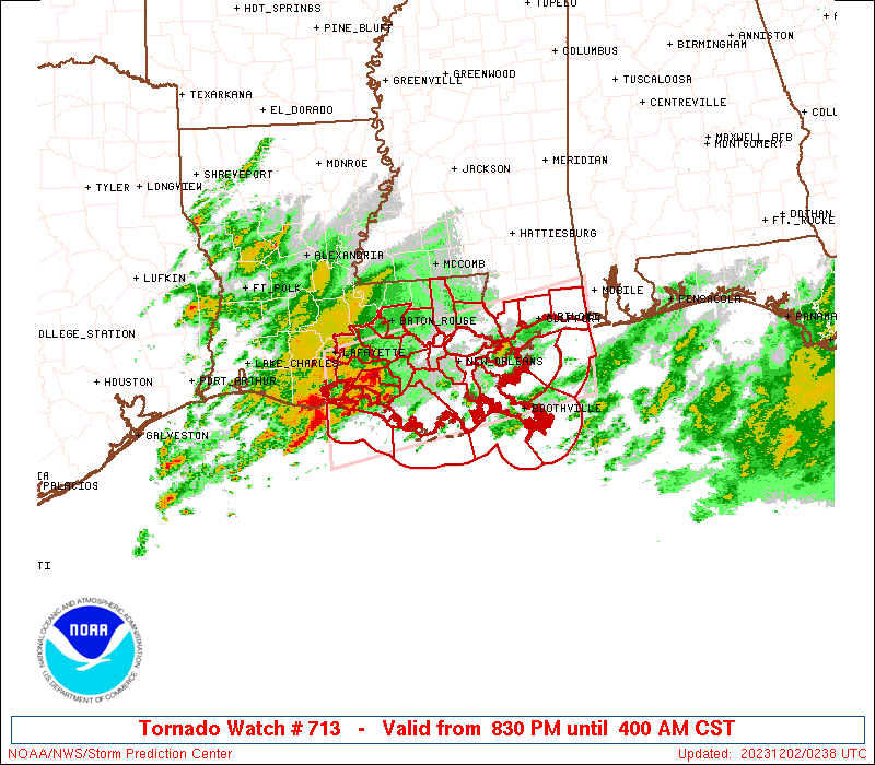
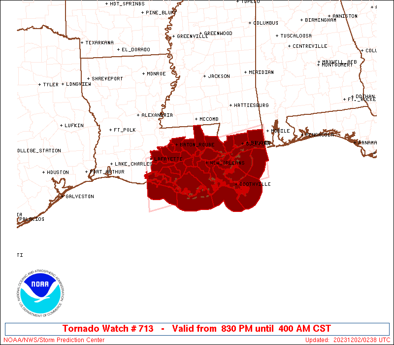
Watch 713 Status Report Messages:
STATUS REPORT #7 ON WW 713

VALID 020925Z - 021000Z

SEVERE WEATHER THREAT CONTINUES RIGHT OF A LINE FROM 20 S 7R4 TO
40 S MOB AND 20 S 7R4 TO 40 SSW MOB.

REMAINING VALID PORTION OF WW 713 MAY BE ALLOWED TO EXPIRE AT
02/10Z.
FOR ADDITIONAL INFORMATION SEE MESOSCALE DISCUSSION 2301.

..KERR..12/02/23

ATTN...WFO...LIX...LCH...

&&

STATUS REPORT FOR WT 713

SEVERE WEATHER THREAT CONTINUES FOR THE FOLLOWING AREAS

LAC051-057-071-075-087-089-109-021000-

LA
.    LOUISIANA PARISHES INCLUDED ARE

JEFFERSON	     LAFOURCHE		 ORLEANS
PLAQUEMINES	     ST. BERNARD	 ST. CHARLES
TERREBONNE
$$


GMZ532-534-536-538-550-552-555-557-021000-

CW

.    ADJACENT COASTAL WATERS INCLUDED ARE

MISSISSIPPI SOUND

LAKE BORGNE

CHANDELEUR SOUND

BRETON SOUND

COASTAL WATERS FROM PORT FOURCHON LA TO LOWER ATCHAFALAYA RIVER
LA OUT 20 NM

COASTAL WATERS FROM THE SOUTHWEST PASS OF THE MISSISSIPPI RIVER
TO PORT FOURCHON LOUISIANA OUT 20 NM

COASTAL WATERS FROM BOOTHVILLE LA TO SOUTHWEST PASS OF THE
MISSISSIPPI RIVER OUT 20 NM

COASTAL WATERS FROM PASCAGOULA MISSISSIPPI TO STAKE ISLAND OUT 20
NM

$$
THE WATCH STATUS MESSAGE IS FOR GUIDANCE PURPOSES ONLY.  PLEASE
REFER TO WATCH COUNTY NOTIFICATION STATEMENTS FOR OFFICIAL
INFORMATION ON COUNTIES...INDEPENDENT CITIES AND MARINE ZONES
CLEARED FROM SEVERE THUNDERSTORM AND TORNADO WATCHES.
$$

STATUS REPORT #6 ON WW 713

VALID 020830Z - 020940Z

SEVERE WEATHER THREAT CONTINUES RIGHT OF A LINE FROM 15 S 7R4 TO
25 SSW MOB.

..KERR..12/02/23

ATTN...WFO...LIX...LCH...

&&

STATUS REPORT FOR WT 713

SEVERE WEATHER THREAT CONTINUES FOR THE FOLLOWING AREAS

LAC051-057-071-075-087-089-109-020940-

LA
.    LOUISIANA PARISHES INCLUDED ARE

JEFFERSON	     LAFOURCHE		 ORLEANS
PLAQUEMINES	     ST. BERNARD	 ST. CHARLES
TERREBONNE
$$


GMZ532-534-536-538-550-552-555-557-020940-

CW

.    ADJACENT COASTAL WATERS INCLUDED ARE

MISSISSIPPI SOUND

LAKE BORGNE

CHANDELEUR SOUND

BRETON SOUND

COASTAL WATERS FROM PORT FOURCHON LA TO LOWER ATCHAFALAYA RIVER
LA OUT 20 NM

COASTAL WATERS FROM THE SOUTHWEST PASS OF THE MISSISSIPPI RIVER
TO PORT FOURCHON LOUISIANA OUT 20 NM

COASTAL WATERS FROM BOOTHVILLE LA TO SOUTHWEST PASS OF THE
MISSISSIPPI RIVER OUT 20 NM

COASTAL WATERS FROM PASCAGOULA MISSISSIPPI TO STAKE ISLAND OUT 20
NM

$$
THE WATCH STATUS MESSAGE IS FOR GUIDANCE PURPOSES ONLY.  PLEASE
REFER TO WATCH COUNTY NOTIFICATION STATEMENTS FOR OFFICIAL
INFORMATION ON COUNTIES...INDEPENDENT CITIES AND MARINE ZONES
CLEARED FROM SEVERE THUNDERSTORM AND TORNADO WATCHES.
$$

STATUS REPORT #5 ON WW 713

VALID 020730Z - 020840Z

SEVERE WEATHER THREAT CONTINUES RIGHT OF A LINE FROM 15 S 7R4 TO
25 SSW MOB.

..KERR..12/02/23

ATTN...WFO...LIX...LCH...

&&

STATUS REPORT FOR WT 713

SEVERE WEATHER THREAT CONTINUES FOR THE FOLLOWING AREAS

LAC051-057-071-075-087-089-109-020840-

LA
.    LOUISIANA PARISHES INCLUDED ARE

JEFFERSON	     LAFOURCHE		 ORLEANS
PLAQUEMINES	     ST. BERNARD	 ST. CHARLES
TERREBONNE
$$


GMZ436-455-532-534-536-538-550-552-555-557-020840-

CW

.    ADJACENT COASTAL WATERS INCLUDED ARE


COASTAL WATERS FROM LOWER ATCHAFALAYA RIVER TO INTRACOASTAL CITY
LA OUT 20 NM

MISSISSIPPI SOUND

LAKE BORGNE

CHANDELEUR SOUND

BRETON SOUND

COASTAL WATERS FROM PORT FOURCHON LA TO LOWER ATCHAFALAYA RIVER
LA OUT 20 NM

COASTAL WATERS FROM THE SOUTHWEST PASS OF THE MISSISSIPPI RIVER
TO PORT FOURCHON LOUISIANA OUT 20 NM

COASTAL WATERS FROM BOOTHVILLE LA TO SOUTHWEST PASS OF THE
MISSISSIPPI RIVER OUT 20 NM

COASTAL WATERS FROM PASCAGOULA MISSISSIPPI TO STAKE ISLAND OUT 20
NM

$$
THE WATCH STATUS MESSAGE IS FOR GUIDANCE PURPOSES ONLY.  PLEASE
REFER TO WATCH COUNTY NOTIFICATION STATEMENTS FOR OFFICIAL
INFORMATION ON COUNTIES...INDEPENDENT CITIES AND MARINE ZONES
CLEARED FROM SEVERE THUNDERSTORM AND TORNADO WATCHES.
$$

STATUS REPORT #4 ON WW 713

VALID 020650Z - 020740Z

THE SEVERE WEATHER THREAT CONTINUES ACROSS THE ENTIRE WATCH AREA.

..KERR..12/02/23

ATTN...WFO...LIX...LCH...

&&

STATUS REPORT FOR WT 713

SEVERE WEATHER THREAT CONTINUES FOR THE FOLLOWING AREAS

LAC005-007-033-045-047-051-057-063-071-075-087-089-093-095-099-
101-103-105-109-121-020740-

LA
.    LOUISIANA PARISHES INCLUDED ARE

ASCENSION	     ASSUMPTION 	 EAST BATON ROUGE
IBERIA		     IBERVILLE		 JEFFERSON
LAFOURCHE	     LIVINGSTON 	 ORLEANS
PLAQUEMINES	     ST. BERNARD	 ST. CHARLES
ST. JAMES	     ST. JOHN THE BAPTISTST. MARTIN
ST. MARY	     ST. TAMMANY	 TANGIPAHOA
TERREBONNE	     WEST BATON ROUGE
$$


MSC045-047-059-020740-

MS
.    MISSISSIPPI COUNTIES INCLUDED ARE

HANCOCK 	     HARRISON		 JACKSON
$$


GMZ435-436-455-530-532-534-536-538-550-552-555-557-020740-

CW

.    ADJACENT COASTAL WATERS INCLUDED ARE

VERMILION BAY


COASTAL WATERS FROM LOWER ATCHAFALAYA RIVER TO INTRACOASTAL CITY
LA OUT 20 NM

LAKE PONTCHARTRAIN AND LAKE MAUREPAS

MISSISSIPPI SOUND

LAKE BORGNE

CHANDELEUR SOUND

BRETON SOUND

COASTAL WATERS FROM PORT FOURCHON LA TO LOWER ATCHAFALAYA RIVER
LA OUT 20 NM

COASTAL WATERS FROM THE SOUTHWEST PASS OF THE MISSISSIPPI RIVER
TO PORT FOURCHON LOUISIANA OUT 20 NM

COASTAL WATERS FROM BOOTHVILLE LA TO SOUTHWEST PASS OF THE
MISSISSIPPI RIVER OUT 20 NM

COASTAL WATERS FROM PASCAGOULA MISSISSIPPI TO STAKE ISLAND OUT 20
NM

$$
THE WATCH STATUS MESSAGE IS FOR GUIDANCE PURPOSES ONLY.  PLEASE
REFER TO WATCH COUNTY NOTIFICATION STATEMENTS FOR OFFICIAL
INFORMATION ON COUNTIES...INDEPENDENT CITIES AND MARINE ZONES
CLEARED FROM SEVERE THUNDERSTORM AND TORNADO WATCHES.
$$

STATUS REPORT #3 ON WW 713

VALID 020540Z - 020640Z

SEVERE WEATHER THREAT CONTINUES RIGHT OF A LINE FROM 15 S 7R4 TO
20 N HUM TO 20 NNW ASD.

FOR ADDITIONAL INFORMATION SEE MESOSCALE DISCUSSION 2300.

..GRAMS..12/02/23

ATTN...WFO...LIX...LCH...

&&

STATUS REPORT FOR WT 713

SEVERE WEATHER THREAT CONTINUES FOR THE FOLLOWING AREAS

LAC051-057-071-075-087-089-103-109-020640-

LA
.    LOUISIANA PARISHES INCLUDED ARE

JEFFERSON	     LAFOURCHE		 ORLEANS
PLAQUEMINES	     ST. BERNARD	 ST. CHARLES
ST. TAMMANY	     TERREBONNE
$$


MSC045-047-059-020640-

MS
.    MISSISSIPPI COUNTIES INCLUDED ARE

HANCOCK 	     HARRISON		 JACKSON
$$


GMZ436-455-530-532-534-536-538-550-552-555-557-020640-

CW

.    ADJACENT COASTAL WATERS INCLUDED ARE


COASTAL WATERS FROM LOWER ATCHAFALAYA RIVER TO INTRACOASTAL CITY
LA OUT 20 NM

LAKE PONTCHARTRAIN AND LAKE MAUREPAS

MISSISSIPPI SOUND

LAKE BORGNE

CHANDELEUR SOUND

BRETON SOUND

COASTAL WATERS FROM PORT FOURCHON LA TO LOWER ATCHAFALAYA RIVER
LA OUT 20 NM

COASTAL WATERS FROM THE SOUTHWEST PASS OF THE MISSISSIPPI RIVER
TO PORT FOURCHON LOUISIANA OUT 20 NM

COASTAL WATERS FROM BOOTHVILLE LA TO SOUTHWEST PASS OF THE
MISSISSIPPI RIVER OUT 20 NM

COASTAL WATERS FROM PASCAGOULA MISSISSIPPI TO STAKE ISLAND OUT 20
NM

$$
THE WATCH STATUS MESSAGE IS FOR GUIDANCE PURPOSES ONLY.  PLEASE
REFER TO WATCH COUNTY NOTIFICATION STATEMENTS FOR OFFICIAL
INFORMATION ON COUNTIES...INDEPENDENT CITIES AND MARINE ZONES
CLEARED FROM SEVERE THUNDERSTORM AND TORNADO WATCHES.
$$

STATUS REPORT #2 ON WW 713

VALID 020435Z - 020540Z

THE SEVERE WEATHER THREAT CONTINUES ACROSS THE ENTIRE WATCH AREA.

..GRAMS..12/02/23

ATTN...WFO...LIX...LCH...

&&

STATUS REPORT FOR WT 713

SEVERE WEATHER THREAT CONTINUES FOR THE FOLLOWING AREAS

LAC005-007-033-045-047-051-057-063-071-075-087-089-093-095-099-
101-103-105-109-121-020540-

LA
.    LOUISIANA PARISHES INCLUDED ARE

ASCENSION	     ASSUMPTION 	 EAST BATON ROUGE
IBERIA		     IBERVILLE		 JEFFERSON
LAFOURCHE	     LIVINGSTON 	 ORLEANS
PLAQUEMINES	     ST. BERNARD	 ST. CHARLES
ST. JAMES	     ST. JOHN THE BAPTISTST. MARTIN
ST. MARY	     ST. TAMMANY	 TANGIPAHOA
TERREBONNE	     WEST BATON ROUGE
$$


MSC045-047-059-020540-

MS
.    MISSISSIPPI COUNTIES INCLUDED ARE

HANCOCK 	     HARRISON		 JACKSON
$$


GMZ435-436-455-530-532-534-536-538-550-552-555-557-020540-

CW

.    ADJACENT COASTAL WATERS INCLUDED ARE

VERMILION BAY


COASTAL WATERS FROM LOWER ATCHAFALAYA RIVER TO INTRACOASTAL CITY
LA OUT 20 NM

LAKE PONTCHARTRAIN AND LAKE MAUREPAS

MISSISSIPPI SOUND

LAKE BORGNE

CHANDELEUR SOUND

BRETON SOUND

COASTAL WATERS FROM PORT FOURCHON LA TO LOWER ATCHAFALAYA RIVER
LA OUT 20 NM

COASTAL WATERS FROM THE SOUTHWEST PASS OF THE MISSISSIPPI RIVER
TO PORT FOURCHON LOUISIANA OUT 20 NM

COASTAL WATERS FROM BOOTHVILLE LA TO SOUTHWEST PASS OF THE
MISSISSIPPI RIVER OUT 20 NM

COASTAL WATERS FROM PASCAGOULA MISSISSIPPI TO STAKE ISLAND OUT 20
NM

$$
THE WATCH STATUS MESSAGE IS FOR GUIDANCE PURPOSES ONLY.  PLEASE
REFER TO WATCH COUNTY NOTIFICATION STATEMENTS FOR OFFICIAL
INFORMATION ON COUNTIES...INDEPENDENT CITIES AND MARINE ZONES
CLEARED FROM SEVERE THUNDERSTORM AND TORNADO WATCHES.
$$

STATUS REPORT #1 ON WW 713

VALID 020345Z - 020440Z

THE SEVERE WEATHER THREAT CONTINUES ACROSS THE ENTIRE WATCH AREA.

FOR ADDITIONAL INFORMATION SEE MESOSCALE DISCUSSION 2299.

..GRAMS..12/02/23

ATTN...WFO...LIX...LCH...

&&

STATUS REPORT FOR WT 713

SEVERE WEATHER THREAT CONTINUES FOR THE FOLLOWING AREAS

LAC005-007-033-045-047-051-057-063-071-075-087-089-093-095-099-
101-103-105-109-121-020440-

LA
.    LOUISIANA PARISHES INCLUDED ARE

ASCENSION	     ASSUMPTION 	 EAST BATON ROUGE
IBERIA		     IBERVILLE		 JEFFERSON
LAFOURCHE	     LIVINGSTON 	 ORLEANS
PLAQUEMINES	     ST. BERNARD	 ST. CHARLES
ST. JAMES	     ST. JOHN THE BAPTISTST. MARTIN
ST. MARY	     ST. TAMMANY	 TANGIPAHOA
TERREBONNE	     WEST BATON ROUGE
$$


MSC045-047-059-020440-

MS
.    MISSISSIPPI COUNTIES INCLUDED ARE

HANCOCK 	     HARRISON		 JACKSON
$$


GMZ435-436-455-530-532-534-536-538-550-552-555-557-020440-

CW

.    ADJACENT COASTAL WATERS INCLUDED ARE

VERMILION BAY


COASTAL WATERS FROM LOWER ATCHAFALAYA RIVER TO INTRACOASTAL CITY
LA OUT 20 NM

LAKE PONTCHARTRAIN AND LAKE MAUREPAS

MISSISSIPPI SOUND

LAKE BORGNE

CHANDELEUR SOUND

BRETON SOUND

COASTAL WATERS FROM PORT FOURCHON LA TO LOWER ATCHAFALAYA RIVER
LA OUT 20 NM

COASTAL WATERS FROM THE SOUTHWEST PASS OF THE MISSISSIPPI RIVER
TO PORT FOURCHON LOUISIANA OUT 20 NM

COASTAL WATERS FROM BOOTHVILLE LA TO SOUTHWEST PASS OF THE
MISSISSIPPI RIVER OUT 20 NM

COASTAL WATERS FROM PASCAGOULA MISSISSIPPI TO STAKE ISLAND OUT 20
NM

$$
THE WATCH STATUS MESSAGE IS FOR GUIDANCE PURPOSES ONLY.  PLEASE
REFER TO WATCH COUNTY NOTIFICATION STATEMENTS FOR OFFICIAL
INFORMATION ON COUNTIES...INDEPENDENT CITIES AND MARINE ZONES
CLEARED FROM SEVERE THUNDERSTORM AND TORNADO WATCHES.
$$
Note:
Click for Complete Product Text.
Tornadoes
Probability of 2 or more tornadoes
|
Mod (40%)
|
Probability of 1 or more strong (EF2-EF5) tornadoes
|
Low (20%)
|
Wind
Probability of 10 or more severe wind events
|
Low (20%)
|
Probability of 1 or more wind events > 65 knots
|
Low (10%)
|
Hail
Probability of 10 or more severe hail events
|
Low (<5%)
|
Probability of 1 or more hailstones > 2 inches
|
Low (<5%)
|
Combined Severe Hail/Wind
Probability of 6 or more combined severe hail/wind events
|
Mod (30%)
|
For each watch, probabilities for particular events inside the watch
(listed above in each table) are determined by the issuing forecaster.
The "Low" category contains probability values ranging from less than 2%
to 20% (EF2-EF5 tornadoes), less than 5% to 20% (all other probabilities),
"Moderate" from 30% to 60%, and "High" from 70% to greater than 95%.
High values are bolded and lighter in color to provide awareness of
an increased threat for a particular event.


 @NWSSPC