 Note:
The expiration time in the watch graphic is amended if the watch is
replaced, cancelled or extended.
Note:
Note:
The expiration time in the watch graphic is amended if the watch is
replaced, cancelled or extended.
Note: Click for
Watch Status Reports.
SEL2
URGENT - IMMEDIATE BROADCAST REQUESTED
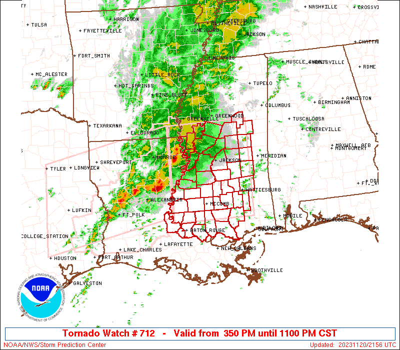
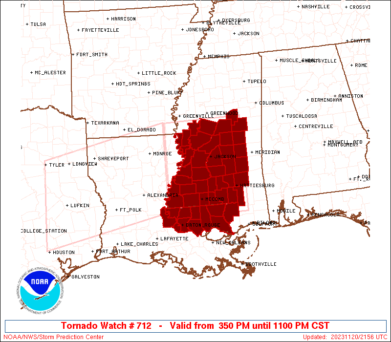
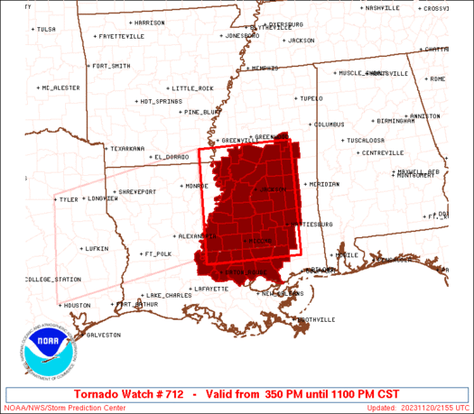
Tornado Watch Number 712
NWS Storm Prediction Center Norman OK
350 PM CST Mon Nov 20 2023
The NWS Storm Prediction Center has issued a
* Tornado Watch for portions of
Southeastern Louisiana
Southern and Central Mississippi
* Effective this Monday afternoon and evening from 350 PM until
1100 PM CST.
* Primary threats include...
A few tornadoes likely with a couple intense tornadoes possible
Scattered damaging wind gusts to 70 mph likely
Isolated large hail events to 1.5 inches in diameter possible
SUMMARY...Thunderstorms will move eastward this afternoon and
evening while posing a threat for tornadoes, damaging winds, and
isolated hail. The threat for strong tornadoes will likely persist
with any sustained supercell.
The tornado watch area is approximately along and 90 statute miles
north and south of a line from 30 miles north northwest of Natchez
MS to 45 miles north northeast of Pine Belt MS. For a complete
depiction of the watch see the associated watch outline update
(WOUS64 KWNS WOU2).
PRECAUTIONARY/PREPAREDNESS ACTIONS...
REMEMBER...A Tornado Watch means conditions are favorable for
tornadoes and severe thunderstorms in and close to the watch
area. Persons in these areas should be on the lookout for
threatening weather conditions and listen for later statements
and possible warnings.
&&
OTHER WATCH INFORMATION...CONTINUE...WW 711...
AVIATION...Tornadoes and a few severe thunderstorms with hail
surface and aloft to 1.5 inches. Extreme turbulence and surface wind
gusts to 60 knots. A few cumulonimbi with maximum tops to 450. Mean
storm motion vector 26040.
...Gleason

   SEL2

   URGENT - IMMEDIATE BROADCAST REQUESTED
   Tornado Watch Number 712
   NWS Storm Prediction Center Norman OK
   350 PM CST Mon Nov 20 2023

   The NWS Storm Prediction Center has issued a

   * Tornado Watch for portions of
     Southeastern Louisiana
     Southern and Central Mississippi

   * Effective this Monday afternoon and evening from 350 PM until
     1100 PM CST.

   * Primary threats include...
     A few tornadoes likely with a couple intense tornadoes possible
     Scattered damaging wind gusts to 70 mph likely
     Isolated large hail events to 1.5 inches in diameter possible

   SUMMARY...Thunderstorms will move eastward this afternoon and
   evening while posing a threat for tornadoes, damaging winds, and
   isolated hail. The threat for strong tornadoes will likely persist
   with any sustained supercell.

   The tornado watch area is approximately along and 90 statute miles
   north and south of a line from 30 miles north northwest of Natchez
   MS to 45 miles north northeast of Pine Belt MS. For a complete
   depiction of the watch see the associated watch outline update
   (WOUS64 KWNS WOU2).

   PRECAUTIONARY/PREPAREDNESS ACTIONS...

   REMEMBER...A Tornado Watch means conditions are favorable for
   tornadoes and severe thunderstorms in and close to the watch
   area. Persons in these areas should be on the lookout for
   threatening weather conditions and listen for later statements
   and possible warnings.

   &&

   OTHER WATCH INFORMATION...CONTINUE...WW 711...

   AVIATION...Tornadoes and a few severe thunderstorms with hail
   surface and aloft to 1.5 inches. Extreme turbulence and surface wind
   gusts to 60 knots. A few cumulonimbi with maximum tops to 450. Mean
   storm motion vector 26040.

   ...Gleason
 Note:
The Aviation Watch (SAW) product is an approximation to the watch area.
The actual watch is depicted by the shaded areas.
Note:
The Aviation Watch (SAW) product is an approximation to the watch area.
The actual watch is depicted by the shaded areas.
SAW2
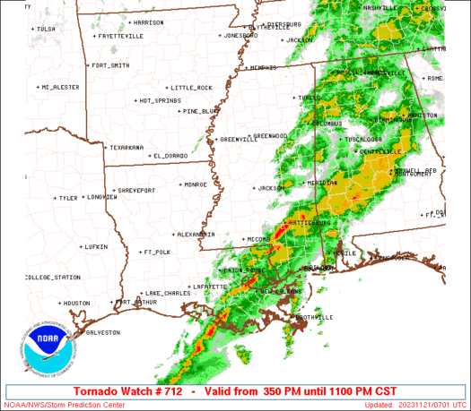
WW 712 TORNADO LA MS 202150Z - 210500Z
AXIS..90 STATUTE MILES NORTH AND SOUTH OF LINE..
30NNW HEZ/NATCHEZ MS/ - 45NNE PIB/PINE BELT MS/
..AVIATION COORDS.. 80NM N/S /40SE MLU - 22SSW MEI/
HAIL SURFACE AND ALOFT..1.5 INCHES. WIND GUSTS..60 KNOTS.
MAX TOPS TO 450. MEAN STORM MOTION VECTOR 26040.
LAT...LON 33329150 33378904 30778904 30729150
THIS IS AN APPROXIMATION TO THE WATCH AREA. FOR A
COMPLETE DEPICTION OF THE WATCH SEE WOUS64 KWNS
FOR WOU2.
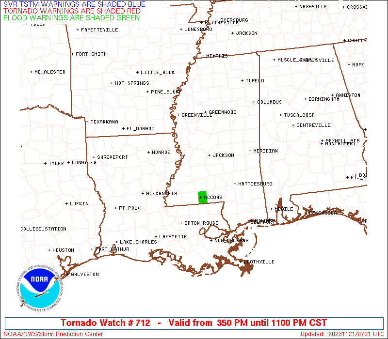
Watch 712 Status Report Messages:
STATUS REPORT #4 ON WW 712

VALID 210250Z - 210340Z

SEVERE WEATHER THREAT CONTINUES RIGHT OF A LINE FROM 15 WSW HEZ
TO 55 NNE MCB TO 45 E GWO.

..LYONS..11/21/23

ATTN...WFO...LIX...JAN...

&&

STATUS REPORT FOR WT 712

SEVERE WEATHER THREAT CONTINUES FOR THE FOLLOWING AREAS

LAC033-037-063-077-091-103-105-117-121-125-210340-

LA
.    LOUISIANA PARISHES INCLUDED ARE

EAST BATON ROUGE     EAST FELICIANA	 LIVINGSTON
POINTE COUPEE	     ST. HELENA 	 ST. TAMMANY
TANGIPAHOA	     WASHINGTON 	 WEST BATON ROUGE
WEST FELICIANA
$$


MSC001-005-019-023-029-031-035-037-061-065-067-069-073-075-077-
079-085-091-099-101-103-109-113-121-123-127-129-147-157-159-
210340-

MS
.    MISSISSIPPI COUNTIES INCLUDED ARE

ADAMS		     AMITE		 CHOCTAW
CLARKE		     COPIAH		 COVINGTON
FORREST 	     FRANKLIN		 JASPER
JEFFERSON DAVIS      JONES		 KEMPER
LAMAR		     LAUDERDALE 	 LAWRENCE
LEAKE		     LINCOLN		 MARION
NESHOBA 	     NEWTON		 NOXUBEE
PEARL RIVER	     PIKE		 RANKIN
SCOTT		     SIMPSON		 SMITH
WALTHALL	     WILKINSON		 WINSTON
$$


THE WATCH STATUS MESSAGE IS FOR GUIDANCE PURPOSES ONLY.  PLEASE
REFER TO WATCH COUNTY NOTIFICATION STATEMENTS FOR OFFICIAL
INFORMATION ON COUNTIES...INDEPENDENT CITIES AND MARINE ZONES
CLEARED FROM SEVERE THUNDERSTORM AND TORNADO WATCHES.
$$

STATUS REPORT #3 ON WW 712

VALID 210150Z - 210240Z

SEVERE WEATHER THREAT CONTINUES RIGHT OF A LINE FROM 20 W HEZ TO
55 ENE HEZ TO 10 E GWO.

..SQUITIERI..11/21/23

ATTN...WFO...LIX...JAN...

&&

STATUS REPORT FOR WT 712

SEVERE WEATHER THREAT CONTINUES FOR THE FOLLOWING AREAS

LAC033-037-063-077-091-103-105-117-121-125-210240-

LA
.    LOUISIANA PARISHES INCLUDED ARE

EAST BATON ROUGE     EAST FELICIANA	 LIVINGSTON
POINTE COUPEE	     ST. HELENA 	 ST. TAMMANY
TANGIPAHOA	     WASHINGTON 	 WEST BATON ROUGE
WEST FELICIANA
$$


MSC001-005-007-019-023-029-031-035-037-051-061-063-065-067-069-
073-075-077-079-085-089-091-099-101-103-109-113-121-123-127-129-
147-157-159-163-210240-

MS
.    MISSISSIPPI COUNTIES INCLUDED ARE

ADAMS		     AMITE		 ATTALA
CHOCTAW 	     CLARKE		 COPIAH
COVINGTON	     FORREST		 FRANKLIN
HOLMES		     JASPER		 JEFFERSON
JEFFERSON DAVIS      JONES		 KEMPER
LAMAR		     LAUDERDALE 	 LAWRENCE
LEAKE		     LINCOLN		 MADISON
MARION		     NESHOBA		 NEWTON
NOXUBEE 	     PEARL RIVER	 PIKE
RANKIN		     SCOTT		 SIMPSON
SMITH		     WALTHALL		 WILKINSON
WINSTON 	     YAZOO
$$


THE WATCH STATUS MESSAGE IS FOR GUIDANCE PURPOSES ONLY.  PLEASE
REFER TO WATCH COUNTY NOTIFICATION STATEMENTS FOR OFFICIAL
INFORMATION ON COUNTIES...INDEPENDENT CITIES AND MARINE ZONES
CLEARED FROM SEVERE THUNDERSTORM AND TORNADO WATCHES.
$$

STATUS REPORT #2 ON WW 712

VALID 210055Z - 210140Z

SEVERE WEATHER THREAT CONTINUES RIGHT OF A LINE FROM 20 WNW HEZ
TO 65 SSW GWO TO 15 E GWO.

..SQUITIERI..11/21/23

ATTN...WFO...LIX...JAN...

&&

STATUS REPORT FOR WT 712

SEVERE WEATHER THREAT CONTINUES FOR THE FOLLOWING AREAS

LAC033-037-063-077-091-103-105-117-121-125-210140-

LA
.    LOUISIANA PARISHES INCLUDED ARE

EAST BATON ROUGE     EAST FELICIANA	 LIVINGSTON
POINTE COUPEE	     ST. HELENA 	 ST. TAMMANY
TANGIPAHOA	     WASHINGTON 	 WEST BATON ROUGE
WEST FELICIANA
$$


MSC001-005-007-019-021-023-029-031-035-037-049-051-061-063-065-
067-069-073-075-077-079-085-089-091-099-101-103-109-113-121-123-
127-129-147-157-159-163-210140-

MS
.    MISSISSIPPI COUNTIES INCLUDED ARE

ADAMS		     AMITE		 ATTALA
CHOCTAW 	     CLAIBORNE		 CLARKE
COPIAH		     COVINGTON		 FORREST
FRANKLIN	     HINDS		 HOLMES
JASPER		     JEFFERSON		 JEFFERSON DAVIS
JONES		     KEMPER		 LAMAR
LAUDERDALE	     LAWRENCE		 LEAKE
LINCOLN 	     MADISON		 MARION
NESHOBA 	     NEWTON		 NOXUBEE
PEARL RIVER	     PIKE		 RANKIN
SCOTT		     SIMPSON		 SMITH
WALTHALL	     WILKINSON		 WINSTON
YAZOO
$$


THE WATCH STATUS MESSAGE IS FOR GUIDANCE PURPOSES ONLY.  PLEASE
REFER TO WATCH COUNTY NOTIFICATION STATEMENTS FOR OFFICIAL
INFORMATION ON COUNTIES...INDEPENDENT CITIES AND MARINE ZONES
CLEARED FROM SEVERE THUNDERSTORM AND TORNADO WATCHES.
$$

STATUS REPORT #1 ON WW 712

VALID 202325Z - 210040Z

SEVERE WEATHER THREAT CONTINUES RIGHT OF A LINE FROM 30 SE MLU TO
50 S GLH TO 5 WSW GWO.

..SQUITIERI..11/20/23

ATTN...WFO...LIX...JAN...

&&

STATUS REPORT FOR WT 712

SEVERE WEATHER THREAT CONTINUES FOR THE FOLLOWING AREAS

LAC033-037-063-077-091-103-105-117-121-125-210040-

LA
.    LOUISIANA PARISHES INCLUDED ARE

EAST BATON ROUGE     EAST FELICIANA	 LIVINGSTON
POINTE COUPEE	     ST. HELENA 	 ST. TAMMANY
TANGIPAHOA	     WASHINGTON 	 WEST BATON ROUGE
WEST FELICIANA
$$


MSC001-005-007-019-021-029-031-035-037-049-051-061-063-065-067-
073-077-079-085-089-091-099-101-109-113-121-123-127-129-147-149-
157-159-163-210040-

MS
.    MISSISSIPPI COUNTIES INCLUDED ARE

ADAMS		     AMITE		 ATTALA
CHOCTAW 	     CLAIBORNE		 COPIAH
COVINGTON	     FORREST		 FRANKLIN
HINDS		     HOLMES		 JASPER
JEFFERSON	     JEFFERSON DAVIS	 JONES
LAMAR		     LAWRENCE		 LEAKE
LINCOLN 	     MADISON		 MARION
NESHOBA 	     NEWTON		 PEARL RIVER
PIKE		     RANKIN		 SCOTT
SIMPSON 	     SMITH		 WALTHALL
WARREN		     WILKINSON		 WINSTON
YAZOO
$$


THE WATCH STATUS MESSAGE IS FOR GUIDANCE PURPOSES ONLY.  PLEASE
REFER TO WATCH COUNTY NOTIFICATION STATEMENTS FOR OFFICIAL
INFORMATION ON COUNTIES...INDEPENDENT CITIES AND MARINE ZONES
CLEARED FROM SEVERE THUNDERSTORM AND TORNADO WATCHES.
$$
Note:
Click for Complete Product Text.
Tornadoes
Probability of 2 or more tornadoes
|
High (70%)
|
Probability of 1 or more strong (EF2-EF5) tornadoes
|
Mod (50%)
|
Wind
Probability of 10 or more severe wind events
|
Mod (60%)
|
Probability of 1 or more wind events > 65 knots
|
Low (20%)
|
Hail
Probability of 10 or more severe hail events
|
Mod (30%)
|
Probability of 1 or more hailstones > 2 inches
|
Low (10%)
|
Combined Severe Hail/Wind
Probability of 6 or more combined severe hail/wind events
|
High (80%)
|
For each watch, probabilities for particular events inside the watch
(listed above in each table) are determined by the issuing forecaster.
The "Low" category contains probability values ranging from less than 2%
to 20% (EF2-EF5 tornadoes), less than 5% to 20% (all other probabilities),
"Moderate" from 30% to 60%, and "High" from 70% to greater than 95%.
High values are bolded and lighter in color to provide awareness of
an increased threat for a particular event.


 @NWSSPC