Note:
The expiration time in the watch graphic is amended if the watch is
replaced, cancelled or extended.
Note:
Note:
The expiration time in the watch graphic is amended if the watch is
replaced, cancelled or extended.
Note: Click for
Watch Status Reports.
SEL8
URGENT - IMMEDIATE BROADCAST REQUESTED
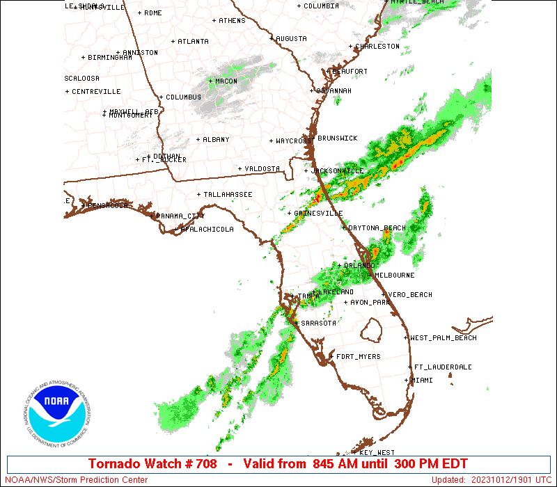
Tornado Watch Number 708
NWS Storm Prediction Center Norman OK
845 AM EDT Thu Oct 12 2023
The NWS Storm Prediction Center has issued a
* Tornado Watch for portions of
Northern and central Florida
Coastal Waters
* Effective this Thursday morning and afternoon from 845 AM until
300 PM EDT.
* Primary threats include...
A few tornadoes possible
Isolated damaging wind gusts to 70 mph possible
SUMMARY...Some supercell/tornado potential should persist through at
least midday across northern and portions of central FL, as
destabilization counterbalances very slowly weakening shear. A few
damaging to severe gusts also may occur from the most vigorous
cells.
The tornado watch area is approximately along and 70 statute miles
either side of a line from 60 miles east northeast of Saint
Petersburg FL to 40 miles north northeast of Cross City FL. For a
complete depiction of the watch see the associated watch outline
update (WOUS64 KWNS WOU8).
PRECAUTIONARY/PREPAREDNESS ACTIONS...
REMEMBER...A Tornado Watch means conditions are favorable for
tornadoes and severe thunderstorms in and close to the watch
area. Persons in these areas should be on the lookout for
threatening weather conditions and listen for later statements
and possible warnings.
&&
OTHER WATCH INFORMATION...This tornado watch replaces tornado
watch number 707. Watch number 707 will not be in effect after
845 AM EDT.
AVIATION...Tornadoes and a few severe thunderstorms with hail
surface and aloft to 1 inch. Extreme turbulence and surface wind
gusts to 60 knots. A few cumulonimbi with maximum tops to 550. Mean
storm motion vector 23030.
...Edwards

   SEL8

   URGENT - IMMEDIATE BROADCAST REQUESTED
   Tornado Watch Number 708
   NWS Storm Prediction Center Norman OK
   845 AM EDT Thu Oct 12 2023

   The NWS Storm Prediction Center has issued a

   * Tornado Watch for portions of
     Northern and central Florida
     Coastal Waters

   * Effective this Thursday morning and afternoon from 845 AM until
     300 PM EDT.

   * Primary threats include...
     A few tornadoes possible
     Isolated damaging wind gusts to 70 mph possible

   SUMMARY...Some supercell/tornado potential should persist through at
   least midday across northern and portions of central FL, as
   destabilization counterbalances very slowly weakening shear.  A few
   damaging to severe gusts also may occur from the most vigorous
   cells.

   The tornado watch area is approximately along and 70 statute miles
   either side of a line from 60 miles east northeast of Saint
   Petersburg FL to 40 miles north northeast of Cross City FL. For a
   complete depiction of the watch see the associated watch outline
   update (WOUS64 KWNS WOU8).

   PRECAUTIONARY/PREPAREDNESS ACTIONS...

   REMEMBER...A Tornado Watch means conditions are favorable for
   tornadoes and severe thunderstorms in and close to the watch
   area. Persons in these areas should be on the lookout for
   threatening weather conditions and listen for later statements
   and possible warnings.

   &&

   OTHER WATCH INFORMATION...This tornado watch replaces tornado
   watch number 707. Watch number 707 will not be in effect after
   845 AM EDT.

   AVIATION...Tornadoes and a few severe thunderstorms with hail
   surface and aloft to 1 inch. Extreme turbulence and surface wind
   gusts to 60 knots. A few cumulonimbi with maximum tops to 550. Mean
   storm motion vector 23030.

   ...Edwards
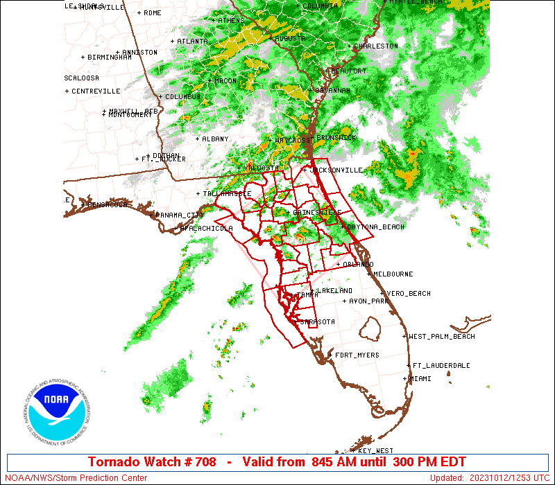
 Note:
The Aviation Watch (SAW) product is an approximation to the watch area.
The actual watch is depicted by the shaded areas.
Note:
The Aviation Watch (SAW) product is an approximation to the watch area.
The actual watch is depicted by the shaded areas.
   SAW8
   WW 708 TORNADO FL CW 121245Z - 121900Z
   AXIS..70 STATUTE MILES EITHER SIDE OF LINE..
   60ENE PIE/SAINT PETERSBURG FL/ - 40NNE CTY/CROSS CITY FL/
   ..AVIATION COORDS.. 60NM EITHER SIDE /29SW ORL - 36NNE CTY/
   HAIL SURFACE AND ALOFT..1 INCH. WIND GUSTS..60 KNOTS.
   MAX TOPS TO 550. MEAN STORM MOTION VECTOR 23030.

   REPLACES WW 707..FL CW

   LAT...LON 27768277 29678387 30658181 28738076

   THIS IS AN APPROXIMATION TO THE WATCH AREA.  FOR A
   COMPLETE DEPICTION OF THE WATCH SEE WOUS64 KWNS
   FOR WOU8.
Watch 708 Status Report Messages:
STATUS REPORT #4 ON WW 708

VALID 121740Z - 121840Z

SEVERE WEATHER THREAT CONTINUES RIGHT OF A LINE FROM 55 SW CTY TO
20 W GNV TO 35 NNW GNV TO 45 NE SGJ.

..MOORE..10/12/23

ATTN...WFO...JAX...TBW...TAE...MLB...

&&

STATUS REPORT FOR WT 708

SEVERE WEATHER THREAT CONTINUES FOR THE FOLLOWING AREAS

FLC001-007-017-019-035-053-057-069-075-081-083-095-101-103-107-
109-117-119-125-127-121840-

FL
.    FLORIDA COUNTIES INCLUDED ARE

ALACHUA 	     BRADFORD		 CITRUS
CLAY		     FLAGLER		 HERNANDO
HILLSBOROUGH	     LAKE		 LEVY
MANATEE 	     MARION		 ORANGE
PASCO		     PINELLAS		 PUTNAM
ST. JOHNS	     SEMINOLE		 SUMTER
UNION		     VOLUSIA
$$


AMZ452-454-550-GMZ830-850-853-121840-

CW

.    ADJACENT COASTAL WATERS INCLUDED ARE

COASTAL WATERS FROM FERNANDINA BEACH TO ST. AUGUSTINE FL OUT 20
NM

COASTAL WATERS FROM ST. AUGUSTINE TO FLAGLER BEACH FL OUT 20 NM

FLAGLER BEACH TO VOLUSIA-BREVARD COUNTY LINE 0-20 NM

TAMPA BAY WATERS

COASTAL WATERS FROM TARPON SPRINGS TO SUWANNEE RIVER FL OUT 20 NM

COASTAL WATERS FROM ENGLEWOOD TO TARPON SPRINGS FL OUT 20 NM

$$
THE WATCH STATUS MESSAGE IS FOR GUIDANCE PURPOSES ONLY.  PLEASE
REFER TO WATCH COUNTY NOTIFICATION STATEMENTS FOR OFFICIAL
INFORMATION ON COUNTIES...INDEPENDENT CITIES AND MARINE ZONES
CLEARED FROM SEVERE THUNDERSTORM AND TORNADO WATCHES.
$$

STATUS REPORT #3 ON WW 708

VALID 121635Z - 121740Z

SEVERE WEATHER THREAT CONTINUES RIGHT OF A LINE FROM 55 SW CTY TO
10 SSE CTY TO 40 NNE CTY TO 30 ENE JAX.

FOR ADDITIONAL INFORMATION SEE MESOSCALE DISCUSSION 2245

..MOORE..10/12/23

ATTN...WFO...JAX...TBW...TAE...MLB...

&&

STATUS REPORT FOR WT 708

SEVERE WEATHER THREAT CONTINUES FOR THE FOLLOWING AREAS

FLC001-007-017-019-023-031-035-041-053-057-069-075-081-083-095-
101-103-107-109-117-119-125-127-121740-

FL
.    FLORIDA COUNTIES INCLUDED ARE

ALACHUA 	     BRADFORD		 CITRUS
CLAY		     COLUMBIA		 DUVAL
FLAGLER 	     GILCHRIST		 HERNANDO
HILLSBOROUGH	     LAKE		 LEVY
MANATEE 	     MARION		 ORANGE
PASCO		     PINELLAS		 PUTNAM
ST. JOHNS	     SEMINOLE		 SUMTER
UNION		     VOLUSIA
$$


AMZ452-454-550-GMZ830-850-853-121740-

CW

.    ADJACENT COASTAL WATERS INCLUDED ARE

COASTAL WATERS FROM FERNANDINA BEACH TO ST. AUGUSTINE FL OUT 20
NM

COASTAL WATERS FROM ST. AUGUSTINE TO FLAGLER BEACH FL OUT 20 NM

FLAGLER BEACH TO VOLUSIA-BREVARD COUNTY LINE 0-20 NM

TAMPA BAY WATERS

COASTAL WATERS FROM TARPON SPRINGS TO SUWANNEE RIVER FL OUT 20 NM

COASTAL WATERS FROM ENGLEWOOD TO TARPON SPRINGS FL OUT 20 NM

$$
THE WATCH STATUS MESSAGE IS FOR GUIDANCE PURPOSES ONLY.  PLEASE
REFER TO WATCH COUNTY NOTIFICATION STATEMENTS FOR OFFICIAL
INFORMATION ON COUNTIES...INDEPENDENT CITIES AND MARINE ZONES
CLEARED FROM SEVERE THUNDERSTORM AND TORNADO WATCHES.
$$

STATUS REPORT #2 ON WW 708

VALID 121510Z - 121630Z

THE SEVERE WEATHER THREAT CONTINUES ACROSS THE ENTIRE WATCH AREA.

..SMITH..10/12/23

ATTN...WFO...JAX...TBW...TAE...MLB...

&&

STATUS REPORT FOR WT 708

SEVERE WEATHER THREAT CONTINUES FOR THE FOLLOWING AREAS

FLC001-003-007-017-019-023-029-031-035-041-053-057-067-069-075-
081-083-095-101-103-107-109-117-119-121-123-125-127-121630-

FL
.    FLORIDA COUNTIES INCLUDED ARE

ALACHUA 	     BAKER		 BRADFORD
CITRUS		     CLAY		 COLUMBIA
DIXIE		     DUVAL		 FLAGLER
GILCHRIST	     HERNANDO		 HILLSBOROUGH
LAFAYETTE	     LAKE		 LEVY
MANATEE 	     MARION		 ORANGE
PASCO		     PINELLAS		 PUTNAM
ST. JOHNS	     SEMINOLE		 SUMTER
SUWANNEE	     TAYLOR		 UNION
VOLUSIA
$$


AMZ452-454-550-GMZ765-830-850-853-121630-

CW

.    ADJACENT COASTAL WATERS INCLUDED ARE

COASTAL WATERS FROM FERNANDINA BEACH TO ST. AUGUSTINE FL OUT 20
NM

COASTAL WATERS FROM ST. AUGUSTINE TO FLAGLER BEACH FL OUT 20 NM

FLAGLER BEACH TO VOLUSIA-BREVARD COUNTY LINE 0-20 NM

COASTAL WATERS FROM  SUWANNEE RIVER TO KEATON BEACH OUT 20 NM

TAMPA BAY WATERS

COASTAL WATERS FROM TARPON SPRINGS TO SUWANNEE RIVER FL OUT 20 NM

COASTAL WATERS FROM ENGLEWOOD TO TARPON SPRINGS FL OUT 20 NM

$$
THE WATCH STATUS MESSAGE IS FOR GUIDANCE PURPOSES ONLY.  PLEASE
REFER TO WATCH COUNTY NOTIFICATION STATEMENTS FOR OFFICIAL
INFORMATION ON COUNTIES...INDEPENDENT CITIES AND MARINE ZONES
CLEARED FROM SEVERE THUNDERSTORM AND TORNADO WATCHES.
$$

STATUS REPORT #1 ON WW 708

VALID 121315Z - 121500Z

THE SEVERE WEATHER THREAT CONTINUES ACROSS THE ENTIRE WATCH AREA.

FOR ADDITIONAL INFORMATION SEE MESOSCALE DISCUSSION 2244

..SMITH..10/12/23

ATTN...WFO...JAX...TBW...TAE...MLB...

&&

STATUS REPORT FOR WT 708

SEVERE WEATHER THREAT CONTINUES FOR THE FOLLOWING AREAS

FLC001-003-007-017-019-023-029-031-035-041-053-057-067-069-075-
081-083-095-101-103-107-109-117-119-121-123-125-127-121500-

FL
.    FLORIDA COUNTIES INCLUDED ARE

ALACHUA 	     BAKER		 BRADFORD
CITRUS		     CLAY		 COLUMBIA
DIXIE		     DUVAL		 FLAGLER
GILCHRIST	     HERNANDO		 HILLSBOROUGH
LAFAYETTE	     LAKE		 LEVY
MANATEE 	     MARION		 ORANGE
PASCO		     PINELLAS		 PUTNAM
ST. JOHNS	     SEMINOLE		 SUMTER
SUWANNEE	     TAYLOR		 UNION
VOLUSIA
$$


AMZ452-454-550-GMZ765-830-850-853-121500-

CW

.    ADJACENT COASTAL WATERS INCLUDED ARE

COASTAL WATERS FROM FERNANDINA BEACH TO ST. AUGUSTINE FL OUT 20
NM

COASTAL WATERS FROM ST. AUGUSTINE TO FLAGLER BEACH FL OUT 20 NM

FLAGLER BEACH TO VOLUSIA-BREVARD COUNTY LINE 0-20 NM

COASTAL WATERS FROM  SUWANNEE RIVER TO KEATON BEACH OUT 20 NM

TAMPA BAY WATERS

COASTAL WATERS FROM TARPON SPRINGS TO SUWANNEE RIVER FL OUT 20 NM

COASTAL WATERS FROM ENGLEWOOD TO TARPON SPRINGS FL OUT 20 NM

$$
THE WATCH STATUS MESSAGE IS FOR GUIDANCE PURPOSES ONLY.  PLEASE
REFER TO WATCH COUNTY NOTIFICATION STATEMENTS FOR OFFICIAL
INFORMATION ON COUNTIES...INDEPENDENT CITIES AND MARINE ZONES
CLEARED FROM SEVERE THUNDERSTORM AND TORNADO WATCHES.
$$
Note:
Click for Complete Product Text.
Tornadoes
Probability of 2 or more tornadoes
|
Mod (50%)
|
Probability of 1 or more strong (EF2-EF5) tornadoes
|
Low (20%)
|
Wind
Probability of 10 or more severe wind events
|
Low (20%)
|
Probability of 1 or more wind events > 65 knots
|
Low (20%)
|
Hail
Probability of 10 or more severe hail events
|
Low (<5%)
|
Probability of 1 or more hailstones > 2 inches
|
Low (<5%)
|
Combined Severe Hail/Wind
Probability of 6 or more combined severe hail/wind events
|
Mod (30%)
|
For each watch, probabilities for particular events inside the watch
(listed above in each table) are determined by the issuing forecaster.
The "Low" category contains probability values ranging from less than 2%
to 20% (EF2-EF5 tornadoes), less than 5% to 20% (all other probabilities),
"Moderate" from 30% to 60%, and "High" from 70% to greater than 95%.
High values are bolded and lighter in color to provide awareness of
an increased threat for a particular event.


 @NWSSPC