Note:
The expiration time in the watch graphic is amended if the watch is
replaced, cancelled or extended.
Note:
Note:
The expiration time in the watch graphic is amended if the watch is
replaced, cancelled or extended.
Note: Click for
Watch Status Reports.
SEL7
URGENT - IMMEDIATE BROADCAST REQUESTED
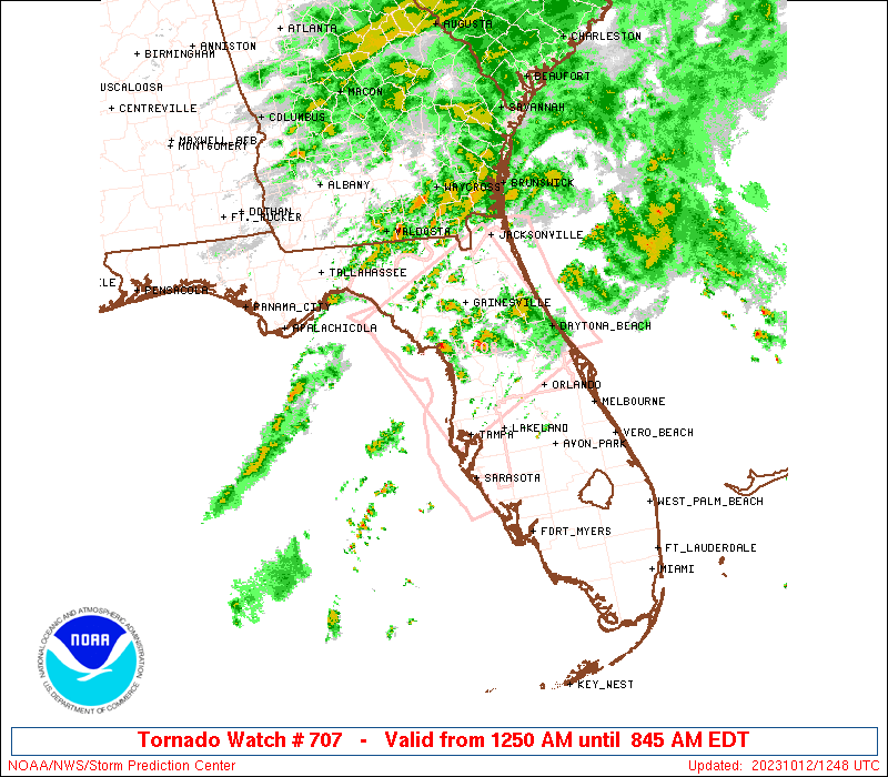
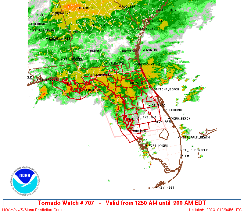
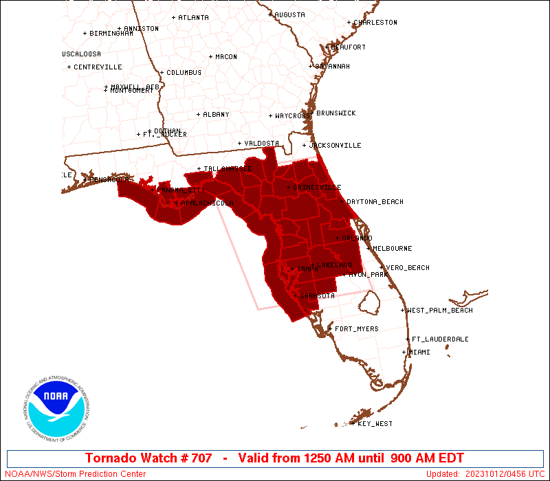
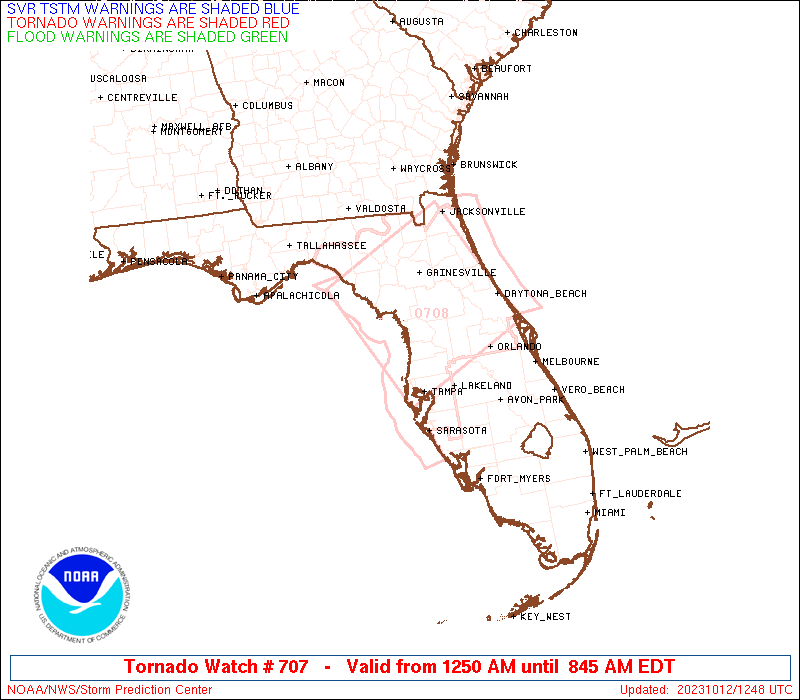
Tornado Watch Number 707
NWS Storm Prediction Center Norman OK
1250 AM EDT Thu Oct 12 2023
The NWS Storm Prediction Center has issued a
* Tornado Watch for portions of
Northern and Central Florida
Coastal Waters
* Effective this Thursday morning from 1250 AM until 900 AM EDT.
* Primary threats include...
A couple tornadoes possible
Isolated damaging wind gusts to 65 mph possible
SUMMARY...Stronger thunderstorms are expected to develop and/or move
inland across the central and northern Peninsula through the early
morning hours as conditions become increasingly favorable for the
possibility of tornadoes.
The tornado watch area is approximately along and 85 statute miles
east and west of a line from 45 miles north northeast of Cross City
FL to 30 miles east southeast of Sarasota FL. For a complete
depiction of the watch see the associated watch outline update
(WOUS64 KWNS WOU7).
PRECAUTIONARY/PREPAREDNESS ACTIONS...
REMEMBER...A Tornado Watch means conditions are favorable for
tornadoes and severe thunderstorms in and close to the watch
area. Persons in these areas should be on the lookout for
threatening weather conditions and listen for later statements
and possible warnings.
&&
AVIATION...Tornadoes and a few severe thunderstorms with hail
surface and aloft to 0.5 inches. Extreme turbulence and surface wind
gusts to 55 knots. A few cumulonimbi with maximum tops to 500. Mean
storm motion vector 24030.
...Guyer
 Note:
The Aviation Watch (SAW) product is an approximation to the watch area.
The actual watch is depicted by the shaded areas.
Note:
The Aviation Watch (SAW) product is an approximation to the watch area.
The actual watch is depicted by the shaded areas.
   SAW7
   WW 707 TORNADO FL CW 120450Z - 121300Z
   AXIS..85 STATUTE MILES EAST AND WEST OF LINE..
   45NNE CTY/CROSS CITY FL/ - 30ESE SRQ/SARASOTA FL/
   ..AVIATION COORDS.. 75NM E/W /40NNE CTY - 26ESE SRQ/
   HAIL SURFACE AND ALOFT..0.5 INCH. WIND GUSTS..55 KNOTS.
   MAX TOPS TO 500. MEAN STORM MOTION VECTOR 24030.

   LAT...LON 30228139 27238072 27238348 30228424

   THIS IS AN APPROXIMATION TO THE WATCH AREA.  FOR A
   COMPLETE DEPICTION OF THE WATCH SEE WOUS64 KWNS
   FOR WOU7.
Watch 707 Status Report Messages:
STATUS REPORT #4 ON WW 707

VALID 121050Z - 121140Z

THE SEVERE WEATHER THREAT CONTINUES ACROSS THE ENTIRE WATCH AREA.

..BROYLES..10/12/23

ATTN...WFO...JAX...TBW...TAE...MLB...

&&

STATUS REPORT FOR WT 707

SEVERE WEATHER THREAT CONTINUES FOR THE FOLLOWING AREAS

FLC001-007-017-019-023-029-035-037-041-045-049-053-057-067-069-
075-081-083-095-097-101-103-105-107-109-115-117-119-121-123-125-
127-129-121140-

FL
.    FLORIDA COUNTIES INCLUDED ARE

ALACHUA 	     BRADFORD		 CITRUS
CLAY		     COLUMBIA		 DIXIE
FLAGLER 	     FRANKLIN		 GILCHRIST
GULF		     HARDEE		 HERNANDO
HILLSBOROUGH	     LAFAYETTE		 LAKE
LEVY		     MANATEE		 MARION
ORANGE		     OSCEOLA		 PASCO
PINELLAS	     POLK		 PUTNAM
ST. JOHNS	     SARASOTA		 SEMINOLE
SUMTER		     SUWANNEE		 TAYLOR
UNION		     VOLUSIA		 WAKULLA
$$


GMZ730-750-752-755-765-830-850-853-121140-

CW

.    ADJACENT COASTAL WATERS INCLUDED ARE

APALACHEE BAY OR COASTAL WATERS FROM KEATON BEACH TO OCHLOCKONEE
RIVER FL OUT TO 20 NM

COASTAL WATERS FROM OKALOOSA-WALTON COUNTY LINE TO MEXICO BEACH
OUT 20 NM

COASTAL WATERS FROM MEXICO BEACH TO APALACHICOLA OUT 20 NM

COASTAL WATERS FROM  OCHLOCKONEE RIVER TO APALACHICOLA FL OUT TO
20 NM

COASTAL WATERS FROM  SUWANNEE RIVER TO KEATON BEACH OUT 20 NM

TAMPA BAY WATERS

COASTAL WATERS FROM TARPON SPRINGS TO SUWANNEE RIVER FL OUT 20 NM

COASTAL WATERS FROM ENGLEWOOD TO TARPON SPRINGS FL OUT 20 NM

$$
THE WATCH STATUS MESSAGE IS FOR GUIDANCE PURPOSES ONLY.  PLEASE
REFER TO WATCH COUNTY NOTIFICATION STATEMENTS FOR OFFICIAL
INFORMATION ON COUNTIES...INDEPENDENT CITIES AND MARINE ZONES
CLEARED FROM SEVERE THUNDERSTORM AND TORNADO WATCHES.
$$

STATUS REPORT #3 ON WW 707

VALID 120920Z - 121040Z

THE SEVERE WEATHER THREAT CONTINUES ACROSS THE ENTIRE WATCH AREA.

..BROYLES..10/12/23

ATTN...WFO...JAX...TBW...TAE...MLB...

&&

STATUS REPORT FOR WT 707

SEVERE WEATHER THREAT CONTINUES FOR THE FOLLOWING AREAS

FLC001-007-017-019-023-029-035-037-041-045-049-053-057-067-069-
075-081-083-095-097-101-103-105-107-109-115-117-119-121-123-125-
127-129-121040-

FL
.    FLORIDA COUNTIES INCLUDED ARE

ALACHUA 	     BRADFORD		 CITRUS
CLAY		     COLUMBIA		 DIXIE
FLAGLER 	     FRANKLIN		 GILCHRIST
GULF		     HARDEE		 HERNANDO
HILLSBOROUGH	     LAFAYETTE		 LAKE
LEVY		     MANATEE		 MARION
ORANGE		     OSCEOLA		 PASCO
PINELLAS	     POLK		 PUTNAM
ST. JOHNS	     SARASOTA		 SEMINOLE
SUMTER		     SUWANNEE		 TAYLOR
UNION		     VOLUSIA		 WAKULLA
$$


GMZ730-750-752-755-765-830-850-853-121040-

CW

.    ADJACENT COASTAL WATERS INCLUDED ARE

APALACHEE BAY OR COASTAL WATERS FROM KEATON BEACH TO OCHLOCKONEE
RIVER FL OUT TO 20 NM

COASTAL WATERS FROM OKALOOSA-WALTON COUNTY LINE TO MEXICO BEACH
OUT 20 NM

COASTAL WATERS FROM MEXICO BEACH TO APALACHICOLA OUT 20 NM

COASTAL WATERS FROM  OCHLOCKONEE RIVER TO APALACHICOLA FL OUT TO
20 NM

COASTAL WATERS FROM  SUWANNEE RIVER TO KEATON BEACH OUT 20 NM

TAMPA BAY WATERS

COASTAL WATERS FROM TARPON SPRINGS TO SUWANNEE RIVER FL OUT 20 NM

COASTAL WATERS FROM ENGLEWOOD TO TARPON SPRINGS FL OUT 20 NM

$$
THE WATCH STATUS MESSAGE IS FOR GUIDANCE PURPOSES ONLY.  PLEASE
REFER TO WATCH COUNTY NOTIFICATION STATEMENTS FOR OFFICIAL
INFORMATION ON COUNTIES...INDEPENDENT CITIES AND MARINE ZONES
CLEARED FROM SEVERE THUNDERSTORM AND TORNADO WATCHES.
$$

STATUS REPORT #2 ON WW 707

VALID 120715Z - 120840Z

THE SEVERE WEATHER THREAT CONTINUES ACROSS THE ENTIRE WATCH AREA.

..BROYLES..10/12/23

ATTN...WFO...JAX...TBW...TAE...MLB...

&&

STATUS REPORT FOR WT 707

SEVERE WEATHER THREAT CONTINUES FOR THE FOLLOWING AREAS

FLC001-007-017-019-023-029-035-037-041-045-049-053-057-067-069-
075-081-083-095-097-101-103-105-107-109-115-117-119-121-123-125-
127-129-120840-

FL
.    FLORIDA COUNTIES INCLUDED ARE

ALACHUA 	     BRADFORD		 CITRUS
CLAY		     COLUMBIA		 DIXIE
FLAGLER 	     FRANKLIN		 GILCHRIST
GULF		     HARDEE		 HERNANDO
HILLSBOROUGH	     LAFAYETTE		 LAKE
LEVY		     MANATEE		 MARION
ORANGE		     OSCEOLA		 PASCO
PINELLAS	     POLK		 PUTNAM
ST. JOHNS	     SARASOTA		 SEMINOLE
SUMTER		     SUWANNEE		 TAYLOR
UNION		     VOLUSIA		 WAKULLA
$$


GMZ730-750-752-755-765-830-850-853-120840-

CW

.    ADJACENT COASTAL WATERS INCLUDED ARE

APALACHEE BAY OR COASTAL WATERS FROM KEATON BEACH TO OCHLOCKONEE
RIVER FL OUT TO 20 NM

COASTAL WATERS FROM OKALOOSA-WALTON COUNTY LINE TO MEXICO BEACH
OUT 20 NM

COASTAL WATERS FROM MEXICO BEACH TO APALACHICOLA OUT 20 NM

COASTAL WATERS FROM  OCHLOCKONEE RIVER TO APALACHICOLA FL OUT TO
20 NM

COASTAL WATERS FROM  SUWANNEE RIVER TO KEATON BEACH OUT 20 NM

TAMPA BAY WATERS

COASTAL WATERS FROM TARPON SPRINGS TO SUWANNEE RIVER FL OUT 20 NM

COASTAL WATERS FROM ENGLEWOOD TO TARPON SPRINGS FL OUT 20 NM

$$
THE WATCH STATUS MESSAGE IS FOR GUIDANCE PURPOSES ONLY.  PLEASE
REFER TO WATCH COUNTY NOTIFICATION STATEMENTS FOR OFFICIAL
INFORMATION ON COUNTIES...INDEPENDENT CITIES AND MARINE ZONES
CLEARED FROM SEVERE THUNDERSTORM AND TORNADO WATCHES.
$$

STATUS REPORT #1 ON WW 707

VALID 120535Z - 120640Z

THE SEVERE WEATHER THREAT CONTINUES ACROSS THE ENTIRE WATCH AREA.

..BROYLES..10/12/23

ATTN...WFO...JAX...TBW...TAE...MLB...

&&

STATUS REPORT FOR WT 707

SEVERE WEATHER THREAT CONTINUES FOR THE FOLLOWING AREAS

FLC001-007-017-019-023-029-035-037-041-045-049-053-057-067-069-
075-081-083-095-097-101-103-105-107-109-115-117-119-121-123-125-
127-129-120640-

FL
.    FLORIDA COUNTIES INCLUDED ARE

ALACHUA 	     BRADFORD		 CITRUS
CLAY		     COLUMBIA		 DIXIE
FLAGLER 	     FRANKLIN		 GILCHRIST
GULF		     HARDEE		 HERNANDO
HILLSBOROUGH	     LAFAYETTE		 LAKE
LEVY		     MANATEE		 MARION
ORANGE		     OSCEOLA		 PASCO
PINELLAS	     POLK		 PUTNAM
ST. JOHNS	     SARASOTA		 SEMINOLE
SUMTER		     SUWANNEE		 TAYLOR
UNION		     VOLUSIA		 WAKULLA
$$


GMZ730-750-752-755-765-830-850-853-120640-

CW

.    ADJACENT COASTAL WATERS INCLUDED ARE

APALACHEE BAY OR COASTAL WATERS FROM KEATON BEACH TO OCHLOCKONEE
RIVER FL OUT TO 20 NM

COASTAL WATERS FROM OKALOOSA-WALTON COUNTY LINE TO MEXICO BEACH
OUT 20 NM

COASTAL WATERS FROM MEXICO BEACH TO APALACHICOLA OUT 20 NM

COASTAL WATERS FROM  OCHLOCKONEE RIVER TO APALACHICOLA FL OUT TO
20 NM

COASTAL WATERS FROM  SUWANNEE RIVER TO KEATON BEACH OUT 20 NM

TAMPA BAY WATERS

COASTAL WATERS FROM TARPON SPRINGS TO SUWANNEE RIVER FL OUT 20 NM

COASTAL WATERS FROM ENGLEWOOD TO TARPON SPRINGS FL OUT 20 NM

$$
THE WATCH STATUS MESSAGE IS FOR GUIDANCE PURPOSES ONLY.  PLEASE
REFER TO WATCH COUNTY NOTIFICATION STATEMENTS FOR OFFICIAL
INFORMATION ON COUNTIES...INDEPENDENT CITIES AND MARINE ZONES
CLEARED FROM SEVERE THUNDERSTORM AND TORNADO WATCHES.
$$
Note:
Click for Complete Product Text.
Tornadoes
Probability of 2 or more tornadoes
|
Mod (40%)
|
Probability of 1 or more strong (EF2-EF5) tornadoes
|
Low (10%)
|
Wind
Probability of 10 or more severe wind events
|
Low (20%)
|
Probability of 1 or more wind events > 65 knots
|
Low (<5%)
|
Hail
Probability of 10 or more severe hail events
|
Low (<5%)
|
Probability of 1 or more hailstones > 2 inches
|
Low (<5%)
|
Combined Severe Hail/Wind
Probability of 6 or more combined severe hail/wind events
|
Mod (40%)
|
For each watch, probabilities for particular events inside the watch
(listed above in each table) are determined by the issuing forecaster.
The "Low" category contains probability values ranging from less than 2%
to 20% (EF2-EF5 tornadoes), less than 5% to 20% (all other probabilities),
"Moderate" from 30% to 60%, and "High" from 70% to greater than 95%.
High values are bolded and lighter in color to provide awareness of
an increased threat for a particular event.


 @NWSSPC