Note:
The expiration time in the watch graphic is amended if the watch is
replaced, cancelled or extended.
Note:
Note:
The expiration time in the watch graphic is amended if the watch is
replaced, cancelled or extended.
Note: Click for
Watch Status Reports.
SEL6
URGENT - IMMEDIATE BROADCAST REQUESTED
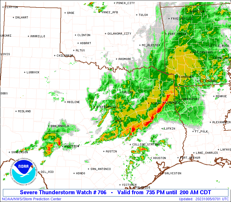
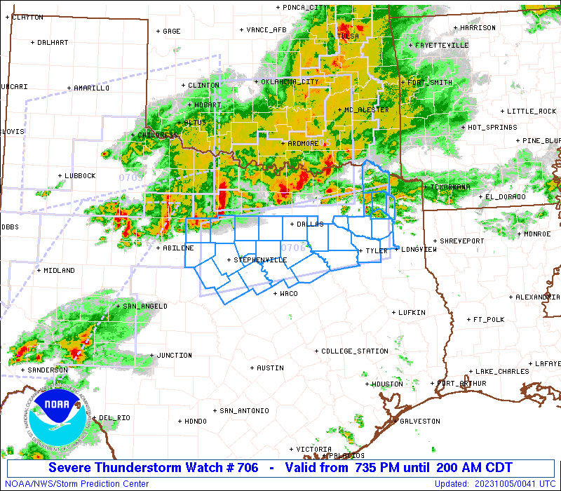
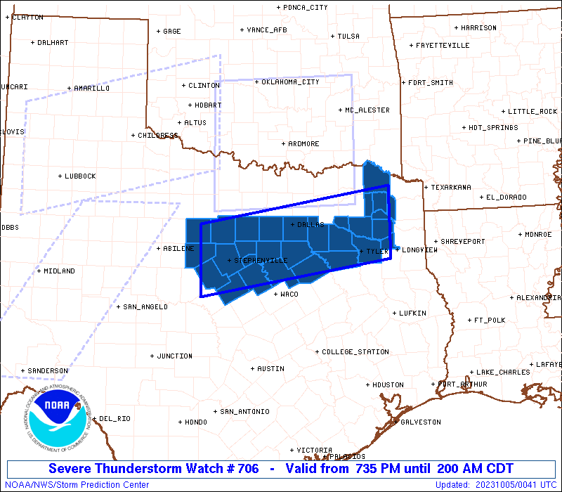
Severe Thunderstorm Watch Number 706
NWS Storm Prediction Center Norman OK
735 PM CDT Wed Oct 4 2023
The NWS Storm Prediction Center has issued a
* Severe Thunderstorm Watch for portions of
North Texas
* Effective this Wednesday night and Thursday morning from 735 PM
until 200 AM CDT.
* Primary threats include...
Scattered large hail and isolated very large hail events to 2
inches in diameter possible
Scattered damaging wind gusts to 70 mph possible
A tornado or two possible
SUMMARY...Clusters of storms will continue to progress generally
southeastward across the region through the evening, including the
DFW Metroplex vicinity. Instances of damaging winds can be expected
along with periodic large hail.
The severe thunderstorm watch area is approximately along and 45
statute miles north and south of a line from 50 miles northeast of
Tyler TX to 35 miles west of Stephenville TX. For a complete
depiction of the watch see the associated watch outline update
(WOUS64 KWNS WOU6).
PRECAUTIONARY/PREPAREDNESS ACTIONS...
REMEMBER...A Severe Thunderstorm Watch means conditions are
favorable for severe thunderstorms in and close to the watch area.
Persons in these areas should be on the lookout for threatening
weather conditions and listen for later statements and possible
warnings. Severe thunderstorms can and occasionally do produce
tornadoes.
&&
OTHER WATCH INFORMATION...CONTINUE...WW 703...WW 704...WW 705...
AVIATION...A few severe thunderstorms with hail surface and aloft to
2 inches. Extreme turbulence and surface wind gusts to 60 knots. A
few cumulonimbi with maximum tops to 600. Mean storm motion vector
30030.
...Guyer

   SEL6

   URGENT - IMMEDIATE BROADCAST REQUESTED
   Severe Thunderstorm Watch Number 706
   NWS Storm Prediction Center Norman OK
   735 PM CDT Wed Oct 4 2023

   The NWS Storm Prediction Center has issued a

   * Severe Thunderstorm Watch for portions of
     North Texas

   * Effective this Wednesday night and Thursday morning from 735 PM
     until 200 AM CDT.

   * Primary threats include...
     Scattered large hail and isolated very large hail events to 2
       inches in diameter possible
     Scattered damaging wind gusts to 70 mph possible
     A tornado or two possible

   SUMMARY...Clusters of storms will continue to progress generally
   southeastward across the region through the evening, including the
   DFW Metroplex vicinity. Instances of damaging winds can be expected
   along with periodic large hail.

   The severe thunderstorm watch area is approximately along and 45
   statute miles north and south of a line from 50 miles northeast of
   Tyler TX to 35 miles west of Stephenville TX. For a complete
   depiction of the watch see the associated watch outline update
   (WOUS64 KWNS WOU6).

   PRECAUTIONARY/PREPAREDNESS ACTIONS...

   REMEMBER...A Severe Thunderstorm Watch means conditions are
   favorable for severe thunderstorms in and close to the watch area.
   Persons in these areas should be on the lookout for threatening
   weather conditions and listen for later statements and possible
   warnings. Severe thunderstorms can and occasionally do produce
   tornadoes.

   &&

   OTHER WATCH INFORMATION...CONTINUE...WW 703...WW 704...WW 705...

   AVIATION...A few severe thunderstorms with hail surface and aloft to
   2 inches. Extreme turbulence and surface wind gusts to 60 knots. A
   few cumulonimbi with maximum tops to 600. Mean storm motion vector
   30030.

   ...Guyer
 Note:
The Aviation Watch (SAW) product is an approximation to the watch area.
The actual watch is depicted by the shaded areas.
Note:
The Aviation Watch (SAW) product is an approximation to the watch area.
The actual watch is depicted by the shaded areas.
   SAW6
   WW 706 SEVERE TSTM TX 050035Z - 050700Z
   AXIS..45 STATUTE MILES NORTH AND SOUTH OF LINE..
   50NE TYR/TYLER TX/ - 35W SEP/STEPHENVILLE TX/
   ..AVIATION COORDS.. 40NM N/S /27N GGG - 57ESE ABI/
   HAIL SURFACE AND ALOFT..2 INCHES. WIND GUSTS..60 KNOTS.
   MAX TOPS TO 600. MEAN STORM MOTION VECTOR 30030.

   LAT...LON 32219479 31579878 32879878 33509479

   THIS IS AN APPROXIMATION TO THE WATCH AREA.  FOR A
   COMPLETE DEPICTION OF THE WATCH SEE WOUS64 KWNS
   FOR WOU6.
Watch 706 Status Report Messages:
STATUS REPORT #3 ON WW 706

VALID 050435Z - 050540Z

SEVERE WEATHER THREAT CONTINUES RIGHT OF A LINE FROM 20 SE BWD TO
30 WNW CRS TO 25 SE DAL TO 50 NW TYR TO 45 WSW TXK.

FOR ADDITIONAL INFORMATION SEE MESOSCALE DISCUSSION 2236

..MOSIER..10/05/23

ATTN...WFO...FWD...SHV...

&&

STATUS REPORT FOR WS 706

SEVERE WEATHER THREAT CONTINUES FOR THE FOLLOWING AREAS

TXC001-035-063-161-183-193-213-217-257-293-343-349-379-423-459-
467-499-050540-

TX
.    TEXAS COUNTIES INCLUDED ARE

ANDERSON	     BOSQUE		 CAMP
FREESTONE	     GREGG		 HAMILTON
HENDERSON	     HILL		 KAUFMAN
LIMESTONE	     MORRIS		 NAVARRO
RAINS		     SMITH		 UPSHUR
VAN ZANDT	     WOOD
$$


THE WATCH STATUS MESSAGE IS FOR GUIDANCE PURPOSES ONLY.  PLEASE
REFER TO WATCH COUNTY NOTIFICATION STATEMENTS FOR OFFICIAL
INFORMATION ON COUNTIES...INDEPENDENT CITIES AND MARINE ZONES
CLEARED FROM SEVERE THUNDERSTORM AND TORNADO WATCHES.
$$

STATUS REPORT #2 ON WW 706

VALID 050300Z - 050440Z

SEVERE WEATHER THREAT CONTINUES RIGHT OF A LINE FROM 45 NNE ABI
TO 20 WSW FTW TO 45 SW PRX TO 30 WSW DEQ.

..LYONS..10/05/23

ATTN...WFO...FWD...SHV...

&&

STATUS REPORT FOR WS 706

SEVERE WEATHER THREAT CONTINUES FOR THE FOLLOWING AREAS

TXC035-063-093-113-133-139-143-159-183-193-213-217-221-251-257-
343-349-363-379-387-397-423-425-429-439-449-459-467-499-
050440-

TX
.    TEXAS COUNTIES INCLUDED ARE

BOSQUE		     CAMP		 COMANCHE
DALLAS		     EASTLAND		 ELLIS
ERATH		     FRANKLIN		 GREGG
HAMILTON	     HENDERSON		 HILL
HOOD		     JOHNSON		 KAUFMAN
MORRIS		     NAVARRO		 PALO PINTO
RAINS		     RED RIVER		 ROCKWALL
SMITH		     SOMERVELL		 STEPHENS
TARRANT 	     TITUS		 UPSHUR
VAN ZANDT	     WOOD
$$


THE WATCH STATUS MESSAGE IS FOR GUIDANCE PURPOSES ONLY.  PLEASE
REFER TO WATCH COUNTY NOTIFICATION STATEMENTS FOR OFFICIAL
INFORMATION ON COUNTIES...INDEPENDENT CITIES AND MARINE ZONES
CLEARED FROM SEVERE THUNDERSTORM AND TORNADO WATCHES.
$$

STATUS REPORT #1 ON WW 706

VALID 050130Z - 050240Z

THE SEVERE WEATHER THREAT CONTINUES ACROSS THE ENTIRE WATCH AREA.

..LYONS..10/05/23

ATTN...WFO...FWD...SHV...

&&

STATUS REPORT FOR WS 706

SEVERE WEATHER THREAT CONTINUES FOR THE FOLLOWING AREAS

TXC035-063-093-113-133-139-143-159-183-193-213-217-221-251-257-
343-349-363-367-379-387-397-423-425-429-439-449-459-467-499-
050240-

TX
.    TEXAS COUNTIES INCLUDED ARE

BOSQUE		     CAMP		 COMANCHE
DALLAS		     EASTLAND		 ELLIS
ERATH		     FRANKLIN		 GREGG
HAMILTON	     HENDERSON		 HILL
HOOD		     JOHNSON		 KAUFMAN
MORRIS		     NAVARRO		 PALO PINTO
PARKER		     RAINS		 RED RIVER
ROCKWALL	     SMITH		 SOMERVELL
STEPHENS	     TARRANT		 TITUS
UPSHUR		     VAN ZANDT		 WOOD
$$


THE WATCH STATUS MESSAGE IS FOR GUIDANCE PURPOSES ONLY.  PLEASE
REFER TO WATCH COUNTY NOTIFICATION STATEMENTS FOR OFFICIAL
INFORMATION ON COUNTIES...INDEPENDENT CITIES AND MARINE ZONES
CLEARED FROM SEVERE THUNDERSTORM AND TORNADO WATCHES.
$$
Note:
Click for Complete Product Text.
Tornadoes
Probability of 2 or more tornadoes
|
Low (20%)
|
Probability of 1 or more strong (EF2-EF5) tornadoes
|
Low (5%)
|
Wind
Probability of 10 or more severe wind events
|
Mod (50%)
|
Probability of 1 or more wind events > 65 knots
|
Low (20%)
|
Hail
Probability of 10 or more severe hail events
|
Mod (40%)
|
Probability of 1 or more hailstones > 2 inches
|
Mod (30%)
|
Combined Severe Hail/Wind
Probability of 6 or more combined severe hail/wind events
|
High (90%)
|
For each watch, probabilities for particular events inside the watch
(listed above in each table) are determined by the issuing forecaster.
The "Low" category contains probability values ranging from less than 2%
to 20% (EF2-EF5 tornadoes), less than 5% to 20% (all other probabilities),
"Moderate" from 30% to 60%, and "High" from 70% to greater than 95%.
High values are bolded and lighter in color to provide awareness of
an increased threat for a particular event.


 @NWSSPC