 Note:
The expiration time in the watch graphic is amended if the watch is
replaced, cancelled or extended.
Note:
Note:
The expiration time in the watch graphic is amended if the watch is
replaced, cancelled or extended.
Note: Click for
Watch Status Reports.
SEL1
URGENT - IMMEDIATE BROADCAST REQUESTED
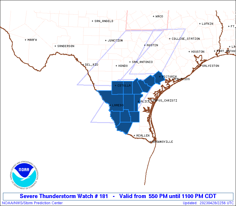
Severe Thunderstorm Watch Number 181
NWS Storm Prediction Center Norman OK
550 PM CDT Fri Apr 28 2023
The NWS Storm Prediction Center has issued a
* Severe Thunderstorm Watch for portions of
South Texas
* Effective this Friday afternoon and evening from 550 PM until
1100 PM CDT.
* Primary threats include...
Scattered damaging winds and isolated significant gusts to 80
mph possible
Scattered large hail and isolated very large hail events to 2.5
inches in diameter possible
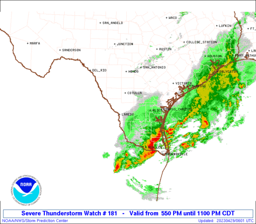
SUMMARY...A few supercells and a broader cluster should eventually
spread southeast across south Texas this evening with threats of
large hail and severe winds.
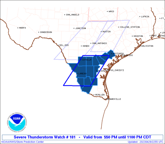
The severe thunderstorm watch area is approximately along and 60
statute miles east and west of a line from 35 miles northwest of
Beeville TX to 55 miles south of Laredo TX. For a complete depiction
of the watch see the associated watch outline update (WOUS64 KWNS
WOU1).
PRECAUTIONARY/PREPAREDNESS ACTIONS...
REMEMBER...A Severe Thunderstorm Watch means conditions are
favorable for severe thunderstorms in and close to the watch area.
Persons in these areas should be on the lookout for threatening
weather conditions and listen for later statements and possible
warnings. Severe thunderstorms can and occasionally do produce
tornadoes.
&&
OTHER WATCH INFORMATION...CONTINUE...WW 177...WW 178...WW
179...WW 180...
AVIATION...A few severe thunderstorms with hail surface and aloft to
2.5 inches. Extreme turbulence and surface wind gusts to 70 knots. A
few cumulonimbi with maximum tops to 550. Mean storm motion vector
31025.
...Grams
 Note:
The Aviation Watch (SAW) product is an approximation to the watch area.
The actual watch is depicted by the shaded areas.
Note:
The Aviation Watch (SAW) product is an approximation to the watch area.
The actual watch is depicted by the shaded areas.
   SAW1
   WW 181 SEVERE TSTM TX 282250Z - 290400Z
   AXIS..60 STATUTE MILES EAST AND WEST OF LINE..
   35NW NIR/BEEVILLE TX/ - 55S LRD/LAREDO TX/
   ..AVIATION COORDS.. 50NM E/W /58SSE SAT - 44S LRD/
   HAIL SURFACE AND ALOFT..2.5 INCHES. WIND GUSTS..70 KNOTS.
   MAX TOPS TO 550. MEAN STORM MOTION VECTOR 31025.

   LAT...LON 28729709 26759850 26750044 28729907

   THIS IS AN APPROXIMATION TO THE WATCH AREA.  FOR A
   COMPLETE DEPICTION OF THE WATCH SEE WOUS64 KWNS
   FOR WOU1.
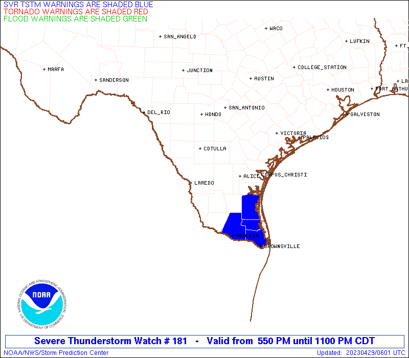
Watch 181 Status Report Messages:
STATUS REPORT #4 ON WW 181

VALID 290235Z - 290340Z

SEVERE WEATHER THREAT CONTINUES RIGHT OF A LINE FROM 30 W LRD TO
10 ESE COT TO 25 SSW VCT.

..BROYLES..04/29/23

ATTN...WFO...CRP...BRO...

&&

STATUS REPORT FOR WS 181

SEVERE WEATHER THREAT CONTINUES FOR THE FOLLOWING AREAS

TXC025-047-131-247-249-283-297-311-427-479-505-290340-

TX
.    TEXAS COUNTIES INCLUDED ARE

BEE		     BROOKS		 DUVAL
JIM HOGG	     JIM WELLS		 LA SALLE
LIVE OAK	     MCMULLEN		 STARR
WEBB		     ZAPATA
$$


THE WATCH STATUS MESSAGE IS FOR GUIDANCE PURPOSES ONLY.  PLEASE
REFER TO WATCH COUNTY NOTIFICATION STATEMENTS FOR OFFICIAL
INFORMATION ON COUNTIES...INDEPENDENT CITIES AND MARINE ZONES
CLEARED FROM SEVERE THUNDERSTORM AND TORNADO WATCHES.
$$

STATUS REPORT #3 ON WW 181

VALID 290135Z - 290240Z

THE SEVERE WEATHER THREAT CONTINUES ACROSS THE ENTIRE WATCH AREA.

..MOORE..04/29/23

ATTN...WFO...CRP...BRO...

&&

STATUS REPORT FOR WS 181

SEVERE WEATHER THREAT CONTINUES FOR THE FOLLOWING AREAS

TXC025-047-131-175-247-249-283-297-311-427-469-479-505-290240-

TX
.    TEXAS COUNTIES INCLUDED ARE

BEE		     BROOKS		 DUVAL
GOLIAD		     JIM HOGG		 JIM WELLS
LA SALLE	     LIVE OAK		 MCMULLEN
STARR		     VICTORIA		 WEBB
ZAPATA
$$


THE WATCH STATUS MESSAGE IS FOR GUIDANCE PURPOSES ONLY.  PLEASE
REFER TO WATCH COUNTY NOTIFICATION STATEMENTS FOR OFFICIAL
INFORMATION ON COUNTIES...INDEPENDENT CITIES AND MARINE ZONES
CLEARED FROM SEVERE THUNDERSTORM AND TORNADO WATCHES.
$$

STATUS REPORT #2 ON WW 181

VALID 290040Z - 290140Z

THE SEVERE WEATHER THREAT CONTINUES ACROSS THE ENTIRE WATCH AREA.

..LYONS..04/29/23

ATTN...WFO...CRP...BRO...

&&

STATUS REPORT FOR WS 181

SEVERE WEATHER THREAT CONTINUES FOR THE FOLLOWING AREAS

TXC025-047-131-175-247-249-283-297-311-427-469-479-505-290140-

TX
.    TEXAS COUNTIES INCLUDED ARE

BEE		     BROOKS		 DUVAL
GOLIAD		     JIM HOGG		 JIM WELLS
LA SALLE	     LIVE OAK		 MCMULLEN
STARR		     VICTORIA		 WEBB
ZAPATA
$$


THE WATCH STATUS MESSAGE IS FOR GUIDANCE PURPOSES ONLY.  PLEASE
REFER TO WATCH COUNTY NOTIFICATION STATEMENTS FOR OFFICIAL
INFORMATION ON COUNTIES...INDEPENDENT CITIES AND MARINE ZONES
CLEARED FROM SEVERE THUNDERSTORM AND TORNADO WATCHES.
$$

STATUS REPORT #1 ON WW 181

VALID 282340Z - 290040Z

THE SEVERE WEATHER THREAT CONTINUES ACROSS THE ENTIRE WATCH AREA.

..LYONS..04/28/23

ATTN...WFO...CRP...BRO...

&&

STATUS REPORT FOR WS 181

SEVERE WEATHER THREAT CONTINUES FOR THE FOLLOWING AREAS

TXC025-047-131-175-247-249-283-297-311-427-469-479-505-290040-

TX
.    TEXAS COUNTIES INCLUDED ARE

BEE		     BROOKS		 DUVAL
GOLIAD		     JIM HOGG		 JIM WELLS
LA SALLE	     LIVE OAK		 MCMULLEN
STARR		     VICTORIA		 WEBB
ZAPATA
$$


THE WATCH STATUS MESSAGE IS FOR GUIDANCE PURPOSES ONLY.  PLEASE
REFER TO WATCH COUNTY NOTIFICATION STATEMENTS FOR OFFICIAL
INFORMATION ON COUNTIES...INDEPENDENT CITIES AND MARINE ZONES
CLEARED FROM SEVERE THUNDERSTORM AND TORNADO WATCHES.
$$
Note:
Click for Complete Product Text.
Tornadoes
Probability of 2 or more tornadoes
|
Low (10%)
|
Probability of 1 or more strong (EF2-EF5) tornadoes
|
Low (5%)
|
Wind
Probability of 10 or more severe wind events
|
Mod (40%)
|
Probability of 1 or more wind events > 65 knots
|
Mod (40%)
|
Hail
Probability of 10 or more severe hail events
|
Mod (40%)
|
Probability of 1 or more hailstones > 2 inches
|
Mod (40%)
|
Combined Severe Hail/Wind
Probability of 6 or more combined severe hail/wind events
|
High (70%)
|
For each watch, probabilities for particular events inside the watch
(listed above in each table) are determined by the issuing forecaster.
The "Low" category contains probability values ranging from less than 2%
to 20% (EF2-EF5 tornadoes), less than 5% to 20% (all other probabilities),
"Moderate" from 30% to 60%, and "High" from 70% to greater than 95%.
High values are bolded and lighter in color to provide awareness of
an increased threat for a particular event.


 @NWSSPC