Note:
The expiration time in the watch graphic is amended if the watch is
replaced, cancelled or extended.
Note:
Note:
The expiration time in the watch graphic is amended if the watch is
replaced, cancelled or extended.
Note: Click for
Watch Status Reports.
SEL0
URGENT - IMMEDIATE BROADCAST REQUESTED
Severe Thunderstorm Watch Number 180
NWS Storm Prediction Center Norman OK
345 PM CDT Fri Apr 28 2023
The NWS Storm Prediction Center has issued a
* Severe Thunderstorm Watch for portions of
Southeast Texas
* Effective this Friday afternoon and evening from 345 PM until
1000 PM CDT.
* Primary threats include...
Scattered damaging winds and isolated significant gusts to 75
mph possible
Scattered large hail and isolated very large hail events to 2
inches in diameter possible
SUMMARY...Consolidating storms along a cold front will surge
southeastward through late evening toward the College Station area,
with an attendant threat for damaging gusts of 60-75 mph and large
hail of 1-2 inches in diameter.
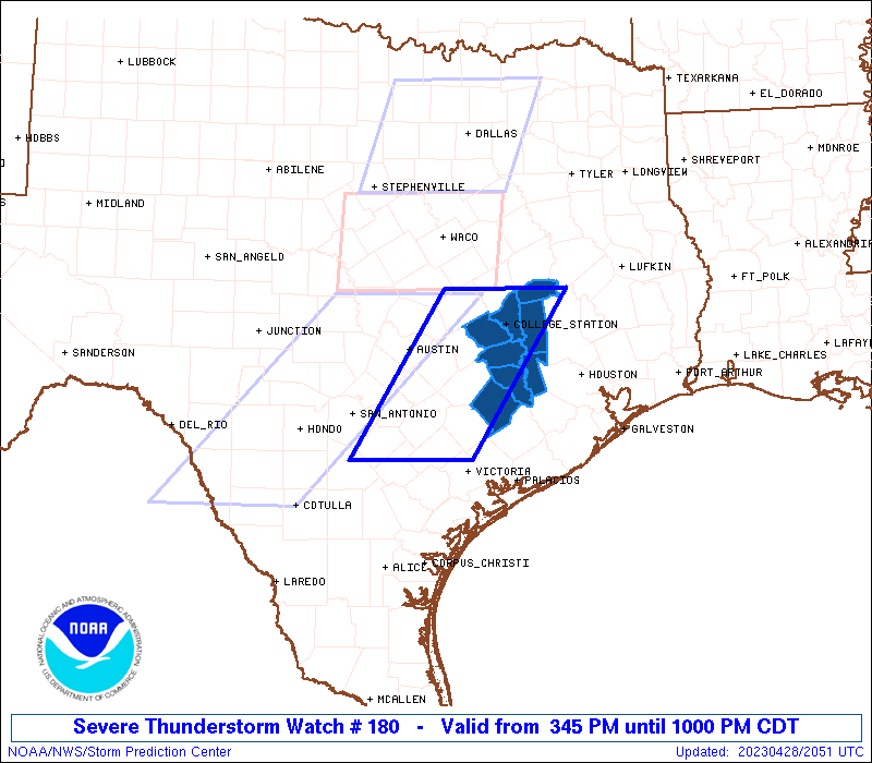
The severe thunderstorm watch area is approximately along and 50
statute miles east and west of a line from 30 miles north of College
Station TX to 55 miles south southeast of New Braunfels TX. For a
complete depiction of the watch see the associated watch outline
update (WOUS64 KWNS WOU0).
PRECAUTIONARY/PREPAREDNESS ACTIONS...
REMEMBER...A Severe Thunderstorm Watch means conditions are
favorable for severe thunderstorms in and close to the watch area.
Persons in these areas should be on the lookout for threatening
weather conditions and listen for later statements and possible
warnings. Severe thunderstorms can and occasionally do produce
tornadoes.
&&
OTHER WATCH INFORMATION...CONTINUE...WW 177...WW 178...WW 179...
AVIATION...A few severe thunderstorms with hail surface and aloft to
2 inches. Extreme turbulence and surface wind gusts to 65 knots. A
few cumulonimbi with maximum tops to 500. Mean storm motion vector
30025.
...Thompson

   SEL0

   URGENT - IMMEDIATE BROADCAST REQUESTED
   Severe Thunderstorm Watch Number 180
   NWS Storm Prediction Center Norman OK
   345 PM CDT Fri Apr 28 2023

   The NWS Storm Prediction Center has issued a

   * Severe Thunderstorm Watch for portions of
     Southeast Texas

   * Effective this Friday afternoon and evening from 345 PM until
     1000 PM CDT.

   * Primary threats include...
     Scattered damaging winds and isolated significant gusts to 75
       mph possible
     Scattered large hail and isolated very large hail events to 2
       inches in diameter possible

   SUMMARY...Consolidating storms along a cold front will surge
   southeastward through late evening toward the College Station area,
   with an attendant threat for damaging gusts of 60-75 mph and large
   hail of 1-2 inches in diameter.

   The severe thunderstorm watch area is approximately along and 50
   statute miles east and west of a line from 30 miles north of College
   Station TX to 55 miles south southeast of New Braunfels TX. For a
   complete depiction of the watch see the associated watch outline
   update (WOUS64 KWNS WOU0).

   PRECAUTIONARY/PREPAREDNESS ACTIONS...

   REMEMBER...A Severe Thunderstorm Watch means conditions are
   favorable for severe thunderstorms in and close to the watch area.
   Persons in these areas should be on the lookout for threatening
   weather conditions and listen for later statements and possible
   warnings. Severe thunderstorms can and occasionally do produce
   tornadoes.

   &&

   OTHER WATCH INFORMATION...CONTINUE...WW 177...WW 178...WW 179...

   AVIATION...A few severe thunderstorms with hail surface and aloft to
   2 inches. Extreme turbulence and surface wind gusts to 65 knots. A
   few cumulonimbi with maximum tops to 500. Mean storm motion vector
   30025.

   ...Thompson
 Note:
The Aviation Watch (SAW) product is an approximation to the watch area.
The actual watch is depicted by the shaded areas.
Note:
The Aviation Watch (SAW) product is an approximation to the watch area.
The actual watch is depicted by the shaded areas.
   SAW0
   WW 180 SEVERE TSTM TX 282045Z - 290300Z
   AXIS..50 STATUTE MILES EAST AND WEST OF LINE..
   30N CLL/COLLEGE STATION TX/ - 55SSE BAZ/NEW BRAUNFELS TX/
   ..AVIATION COORDS.. 45NM E/W /60SE ACT - 57SE SAT/
   HAIL SURFACE AND ALOFT..2 INCHES. WIND GUSTS..65 KNOTS.
   MAX TOPS TO 500. MEAN STORM MOTION VECTOR 30025.

   LAT...LON 31019553 28989685 28989851 31019721

   THIS IS AN APPROXIMATION TO THE WATCH AREA.  FOR A
   COMPLETE DEPICTION OF THE WATCH SEE WOUS64 KWNS
   FOR WOU0.
Watch 180 Status Report Messages:
STATUS REPORT #4 ON WW 180

VALID 290040Z - 290140Z

SEVERE WEATHER THREAT CONTINUES RIGHT OF A LINE FROM 10 S BAZ TO
25 NNW UTS.

..LYONS..04/29/23

ATTN...WFO...HGX...

&&

STATUS REPORT FOR WS 180

SEVERE WEATHER THREAT CONTINUES FOR THE FOLLOWING AREAS

TXC015-089-185-473-477-290140-

TX
.    TEXAS COUNTIES INCLUDED ARE

AUSTIN		     COLORADO		 GRIMES
WALLER		     WASHINGTON
$$


THE WATCH STATUS MESSAGE IS FOR GUIDANCE PURPOSES ONLY.  PLEASE
REFER TO WATCH COUNTY NOTIFICATION STATEMENTS FOR OFFICIAL
INFORMATION ON COUNTIES...INDEPENDENT CITIES AND MARINE ZONES
CLEARED FROM SEVERE THUNDERSTORM AND TORNADO WATCHES.
$$

STATUS REPORT #3 ON WW 180

VALID 282340Z - 290040Z

THE SEVERE WEATHER THREAT CONTINUES ACROSS THE ENTIRE WATCH AREA.

..LYONS..04/28/23

ATTN...WFO...HGX...

&&

STATUS REPORT FOR WS 180

SEVERE WEATHER THREAT CONTINUES FOR THE FOLLOWING AREAS

TXC015-041-051-089-185-313-473-477-290040-

TX
.    TEXAS COUNTIES INCLUDED ARE

AUSTIN		     BRAZOS		 BURLESON
COLORADO	     GRIMES		 MADISON
WALLER		     WASHINGTON
$$


THE WATCH STATUS MESSAGE IS FOR GUIDANCE PURPOSES ONLY.  PLEASE
REFER TO WATCH COUNTY NOTIFICATION STATEMENTS FOR OFFICIAL
INFORMATION ON COUNTIES...INDEPENDENT CITIES AND MARINE ZONES
CLEARED FROM SEVERE THUNDERSTORM AND TORNADO WATCHES.
$$

STATUS REPORT #2 ON WW 180

VALID 282235Z - 282340Z

THE SEVERE WEATHER THREAT CONTINUES ACROSS THE ENTIRE WATCH AREA.

..LYONS..04/28/23

ATTN...WFO...HGX...

&&

STATUS REPORT FOR WS 180

SEVERE WEATHER THREAT CONTINUES FOR THE FOLLOWING AREAS

TXC015-041-051-089-185-313-473-477-282340-

TX
.    TEXAS COUNTIES INCLUDED ARE

AUSTIN		     BRAZOS		 BURLESON
COLORADO	     GRIMES		 MADISON
WALLER		     WASHINGTON
$$


THE WATCH STATUS MESSAGE IS FOR GUIDANCE PURPOSES ONLY.  PLEASE
REFER TO WATCH COUNTY NOTIFICATION STATEMENTS FOR OFFICIAL
INFORMATION ON COUNTIES...INDEPENDENT CITIES AND MARINE ZONES
CLEARED FROM SEVERE THUNDERSTORM AND TORNADO WATCHES.
$$

STATUS REPORT #1 ON WW 180

VALID 282125Z - 282240Z

THE SEVERE WEATHER THREAT CONTINUES ACROSS THE ENTIRE WATCH AREA.

..LYONS..04/28/23

ATTN...WFO...HGX...

&&

STATUS REPORT FOR WS 180

SEVERE WEATHER THREAT CONTINUES FOR THE FOLLOWING AREAS

TXC015-041-051-089-185-313-473-477-282240-

TX
.    TEXAS COUNTIES INCLUDED ARE

AUSTIN		     BRAZOS		 BURLESON
COLORADO	     GRIMES		 MADISON
WALLER		     WASHINGTON
$$


THE WATCH STATUS MESSAGE IS FOR GUIDANCE PURPOSES ONLY.  PLEASE
REFER TO WATCH COUNTY NOTIFICATION STATEMENTS FOR OFFICIAL
INFORMATION ON COUNTIES...INDEPENDENT CITIES AND MARINE ZONES
CLEARED FROM SEVERE THUNDERSTORM AND TORNADO WATCHES.
$$
Note:
Click for Complete Product Text.
Tornadoes
Probability of 2 or more tornadoes
|
Low (10%)
|
Probability of 1 or more strong (EF2-EF5) tornadoes
|
Low (5%)
|
Wind
Probability of 10 or more severe wind events
|
Mod (50%)
|
Probability of 1 or more wind events > 65 knots
|
Mod (40%)
|
Hail
Probability of 10 or more severe hail events
|
Mod (50%)
|
Probability of 1 or more hailstones > 2 inches
|
Mod (40%)
|
Combined Severe Hail/Wind
Probability of 6 or more combined severe hail/wind events
|
High (80%)
|
For each watch, probabilities for particular events inside the watch
(listed above in each table) are determined by the issuing forecaster.
The "Low" category contains probability values ranging from less than 2%
to 20% (EF2-EF5 tornadoes), less than 5% to 20% (all other probabilities),
"Moderate" from 30% to 60%, and "High" from 70% to greater than 95%.
High values are bolded and lighter in color to provide awareness of
an increased threat for a particular event.


 @NWSSPC