 Note:
The expiration time in the watch graphic is amended if the watch is
replaced, cancelled or extended.
Note:
Note:
The expiration time in the watch graphic is amended if the watch is
replaced, cancelled or extended.
Note: Click for
Watch Status Reports.
SEL2
URGENT - IMMEDIATE BROADCAST REQUESTED
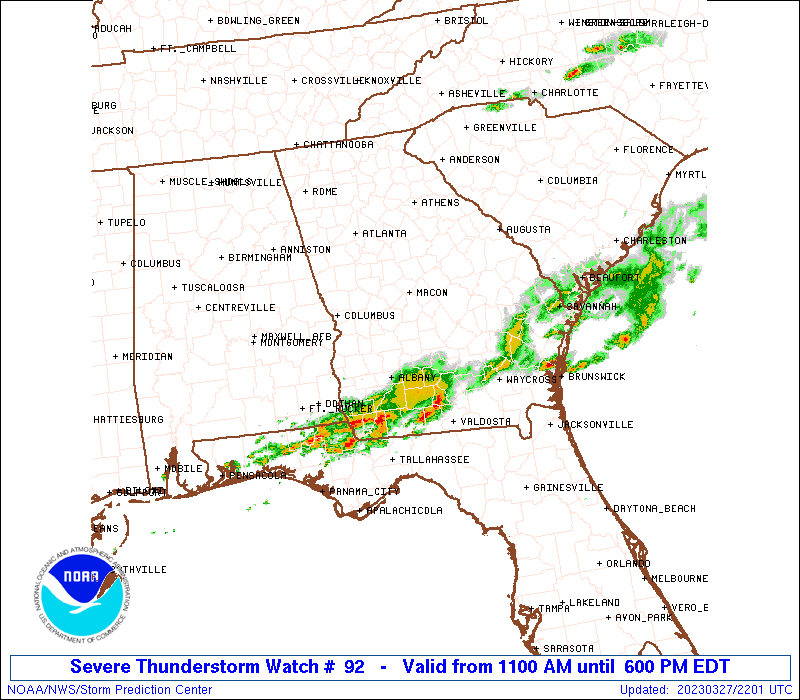
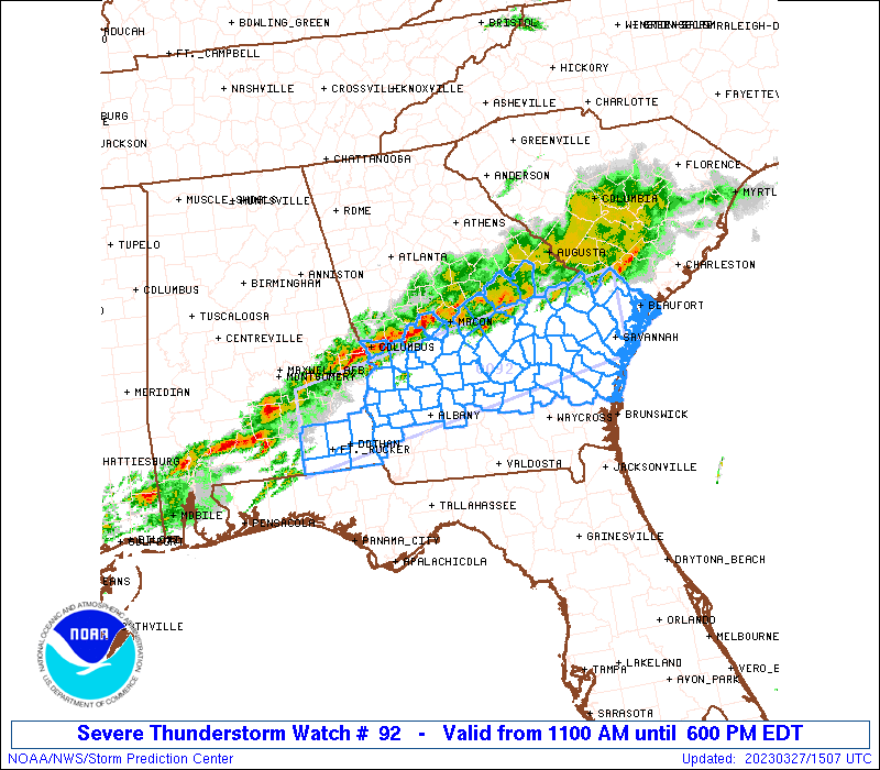
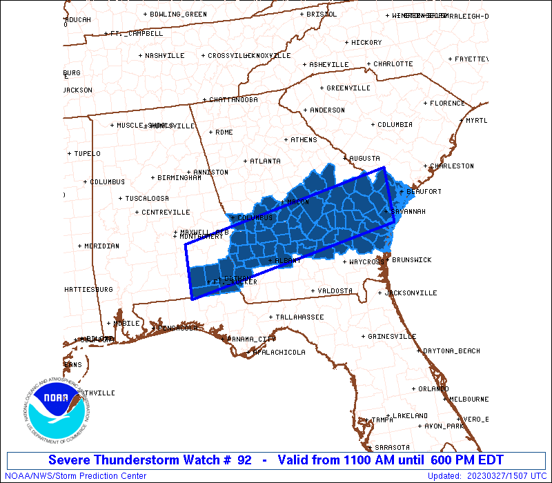
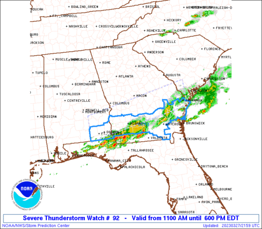
Severe Thunderstorm Watch Number 92
NWS Storm Prediction Center Norman OK
1100 AM EDT Mon Mar 27 2023
The NWS Storm Prediction Center has issued a
* Severe Thunderstorm Watch for portions of
Southeast Alabama
Southern and Central Georgia
Southern South Carolina
* Effective this Monday morning and evening from 1100 AM until
600 PM EDT.
* Primary threats include...
Scattered damaging wind gusts to 65 mph possible
Scattered large hail events to 1.5 inches in diameter possible
A tornado or two possible
SUMMARY...Clusters of storms are expected to gradually intensify
into this afternoon along and south of a boundary across the region,
with the strongest storms capable of a hail and damaging wind risk.
The severe thunderstorm watch area is approximately along and 40
statute miles north and south of a line from 25 miles south
southwest of Troy AL to 25 miles north northeast of Savannah GA. For
a complete depiction of the watch see the associated watch outline
update (WOUS64 KWNS WOU2).
PRECAUTIONARY/PREPAREDNESS ACTIONS...
REMEMBER...A Severe Thunderstorm Watch means conditions are
favorable for severe thunderstorms in and close to the watch area.
Persons in these areas should be on the lookout for threatening
weather conditions and listen for later statements and possible
warnings. Severe thunderstorms can and occasionally do produce
tornadoes.
&&
OTHER WATCH INFORMATION...CONTINUE...WW 91...
AVIATION...A few severe thunderstorms with hail surface and aloft to
1.5 inches. Extreme turbulence and surface wind gusts to 55 knots. A
few cumulonimbi with maximum tops to 550. Mean storm motion vector
25025.
...Guyer

   SEL2

   URGENT - IMMEDIATE BROADCAST REQUESTED
   Severe Thunderstorm Watch Number 92
   NWS Storm Prediction Center Norman OK
   1100 AM EDT Mon Mar 27 2023

   The NWS Storm Prediction Center has issued a

   * Severe Thunderstorm Watch for portions of
     Southeast Alabama
     Southern and Central Georgia
     Southern South Carolina

   * Effective this Monday morning and evening from 1100 AM until
     600 PM EDT.

   * Primary threats include...
     Scattered damaging wind gusts to 65 mph possible
     Scattered large hail events to 1.5 inches in diameter possible
     A tornado or two possible

   SUMMARY...Clusters of storms are expected to gradually intensify
   into this afternoon along and south of a boundary across the region,
   with the strongest storms capable of a hail and damaging wind risk.

   The severe thunderstorm watch area is approximately along and 40
   statute miles north and south of a line from 25 miles south
   southwest of Troy AL to 25 miles north northeast of Savannah GA. For
   a complete depiction of the watch see the associated watch outline
   update (WOUS64 KWNS WOU2).

   PRECAUTIONARY/PREPAREDNESS ACTIONS...

   REMEMBER...A Severe Thunderstorm Watch means conditions are
   favorable for severe thunderstorms in and close to the watch area.
   Persons in these areas should be on the lookout for threatening
   weather conditions and listen for later statements and possible
   warnings. Severe thunderstorms can and occasionally do produce
   tornadoes.

   &&

   OTHER WATCH INFORMATION...CONTINUE...WW 91...

   AVIATION...A few severe thunderstorms with hail surface and aloft to
   1.5 inches. Extreme turbulence and surface wind gusts to 55 knots. A
   few cumulonimbi with maximum tops to 550. Mean storm motion vector
   25025.

   ...Guyer
 Note:
The Aviation Watch (SAW) product is an approximation to the watch area.
The actual watch is depicted by the shaded areas.
Note:
The Aviation Watch (SAW) product is an approximation to the watch area.
The actual watch is depicted by the shaded areas.
   SAW2
   WW 92 SEVERE TSTM AL GA SC 271500Z - 272200Z
   AXIS..40 STATUTE MILES NORTH AND SOUTH OF LINE..
   25SSW TOI/TROY AL/ - 25NNE SAV/SAVANNAH GA/
   ..AVIATION COORDS.. 35NM N/S /42S MGM - 19NNE SAV/
   HAIL SURFACE AND ALOFT..1.5 INCHES. WIND GUSTS..55 KNOTS.
   MAX TOPS TO 550. MEAN STORM MOTION VECTOR 25025.

   LAT...LON 32118618 33048104 31898104 30968618

   THIS IS AN APPROXIMATION TO THE WATCH AREA.  FOR A
   COMPLETE DEPICTION OF THE WATCH SEE WOUS64 KWNS
   FOR WOU2.
Watch 92 Status Report Messages:
STATUS REPORT #4 ON WW 92

VALID 272140Z - 272200Z

SEVERE WEATHER THREAT CONTINUES RIGHT OF A LINE FROM 40 WNW AYS
TO 25 E SAV.

WW 92 WILL BE ALLOWED TO EXPIRE AT 272200Z.

FOR ADDITIONAL INFORMATION SEE MESOSCALE DISCUSSION 377

..WEINMAN..03/27/23

ATTN...WFO...TAE...JAX...FFC...CHS...

&&

STATUS REPORT FOR WS 92

SEVERE WEATHER THREAT CONTINUES FOR THE FOLLOWING AREAS

GAC003-007-019-065-071-075-173-191-201-205-229-277-299-305-
272200-

GA
.    GEORGIA COUNTIES INCLUDED ARE

ATKINSON	     BAKER		 BERRIEN
CLINCH		     COLQUITT		 COOK
LANIER		     MCINTOSH		 MILLER
MITCHELL	     PIERCE		 TIFT
WARE		     WAYNE
$$


THE WATCH STATUS MESSAGE IS FOR GUIDANCE PURPOSES ONLY.  PLEASE
REFER TO WATCH COUNTY NOTIFICATION STATEMENTS FOR OFFICIAL
INFORMATION ON COUNTIES...INDEPENDENT CITIES AND MARINE ZONES
CLEARED FROM SEVERE THUNDERSTORM AND TORNADO WATCHES.
$$

STATUS REPORT #3 ON WW 92

VALID 271900Z - 272040Z

SEVERE WEATHER THREAT CONTINUES RIGHT OF A LINE FROM 40 NE CEW TO
20 ENE DHN TO 25 WNW ABY TO 20 ENE ABY TO 50 WSW VDI TO 20 SW VDI
TO 35 ENE VDI TO 30 NNE SAV.

..LYONS..03/27/23

ATTN...WFO...TAE...JAX...FFC...CHS...

&&

STATUS REPORT FOR WS 92

SEVERE WEATHER THREAT CONTINUES FOR THE FOLLOWING AREAS

ALC061-069-272040-

AL
.    ALABAMA COUNTIES INCLUDED ARE

GENEVA		     HOUSTON
$$


GAC001-005-017-029-037-051-069-095-099-103-109-155-161-179-183-
191-267-271-305-321-272040-

GA
.    GEORGIA COUNTIES INCLUDED ARE

APPLING 	     BACON		 BEN HILL
BRYAN		     CALHOUN		 CHATHAM
COFFEE		     DOUGHERTY		 EARLY
EFFINGHAM	     EVANS		 IRWIN
JEFF DAVIS	     LIBERTY		 LONG
MCINTOSH	     TATTNALL		 TELFAIR
WAYNE		     WORTH
$$


SCC013-053-272040-

SC
.    SOUTH CAROLINA COUNTIES INCLUDED ARE

BEAUFORT	     JASPER
$$


THE WATCH STATUS MESSAGE IS FOR GUIDANCE PURPOSES ONLY.  PLEASE
REFER TO WATCH COUNTY NOTIFICATION STATEMENTS FOR OFFICIAL
INFORMATION ON COUNTIES...INDEPENDENT CITIES AND MARINE ZONES
CLEARED FROM SEVERE THUNDERSTORM AND TORNADO WATCHES.
$$

STATUS REPORT #2 ON WW 92

VALID 271815Z - 271940Z

SEVERE WEATHER THREAT CONTINUES RIGHT OF A LINE FROM 25 SSW TOI
TO 35 NNE DHN TO 35 S CSG TO 40 NNE ABY TO 15 N VDI TO 30 SSW OGB.

FOR ADDITIONAL INFORMATION SEE MESOSCALE DISCUSSION 374

..LYONS..03/27/23

ATTN...WFO...TAE...JAX...FFC...CHS...

&&

STATUS REPORT FOR WS 92

SEVERE WEATHER THREAT CONTINUES FOR THE FOLLOWING AREAS

ALC031-045-061-067-069-271940-

AL
.    ALABAMA COUNTIES INCLUDED ARE

COFFEE		     DALE		 GENEVA
HENRY		     HOUSTON
$$


GAC001-005-017-029-031-037-043-051-061-069-095-099-103-109-155-
161-177-179-183-191-209-239-243-251-267-271-273-279-287-305-309-
321-271940-

GA
.    GEORGIA COUNTIES INCLUDED ARE

APPLING 	     BACON		 BEN HILL
BRYAN		     BULLOCH		 CALHOUN
CANDLER 	     CHATHAM		 CLAY
COFFEE		     DOUGHERTY		 EARLY
EFFINGHAM	     EVANS		 IRWIN
JEFF DAVIS	     LEE		 LIBERTY
LONG		     MCINTOSH		 MONTGOMERY
QUITMAN 	     RANDOLPH		 SCREVEN
TATTNALL	     TELFAIR		 TERRELL
TOOMBS		     TURNER		 WAYNE
WHEELER 	     WORTH
$$


SCC013-049-053-271940-

SC
.    SOUTH CAROLINA COUNTIES INCLUDED ARE

BEAUFORT	     HAMPTON		 JASPER
$$


THE WATCH STATUS MESSAGE IS FOR GUIDANCE PURPOSES ONLY.  PLEASE
REFER TO WATCH COUNTY NOTIFICATION STATEMENTS FOR OFFICIAL
INFORMATION ON COUNTIES...INDEPENDENT CITIES AND MARINE ZONES
CLEARED FROM SEVERE THUNDERSTORM AND TORNADO WATCHES.
$$

STATUS REPORT #1 ON WW 92

VALID 271640Z - 271740Z

SEVERE WEATHER THREAT CONTINUES RIGHT OF A LINE FROM 20 SSW TOI
TO 35 NNE DHN TO 30 E CSG TO 30 SSW OGB.

..MOSIER..03/27/23

ATTN...WFO...TAE...JAX...FFC...CHS...

&&

STATUS REPORT FOR WS 92

SEVERE WEATHER THREAT CONTINUES FOR THE FOLLOWING AREAS

ALC031-045-061-067-069-271740-

AL
.    ALABAMA COUNTIES INCLUDED ARE

COFFEE		     DALE		 GENEVA
HENRY		     HOUSTON
$$


GAC001-005-017-023-029-031-037-043-051-061-069-081-091-093-095-
099-103-107-109-153-155-161-165-167-175-177-179-183-191-193-209-
235-239-243-249-251-259-261-267-271-273-279-283-287-305-307-309-
315-321-271740-

GA
.    GEORGIA COUNTIES INCLUDED ARE

APPLING 	     BACON		 BEN HILL
BLECKLEY	     BRYAN		 BULLOCH
CALHOUN 	     CANDLER		 CHATHAM
CLAY		     COFFEE		 CRISP
DODGE		     DOOLY		 DOUGHERTY
EARLY		     EFFINGHAM		 EMANUEL
EVANS		     HOUSTON		 IRWIN
JEFF DAVIS	     JENKINS		 JOHNSON
LAURENS 	     LEE		 LIBERTY
LONG		     MCINTOSH		 MACON
MONTGOMERY	     PULASKI		 QUITMAN
RANDOLPH	     SCHLEY		 SCREVEN
STEWART 	     SUMTER		 TATTNALL
TELFAIR 	     TERRELL		 TOOMBS
TREUTLEN	     TURNER		 WAYNE
WEBSTER 	     WHEELER		 WILCOX
WORTH
$$


SCC013-049-053-271740-

SC
.    SOUTH CAROLINA COUNTIES INCLUDED ARE

BEAUFORT	     HAMPTON		 JASPER
$$


THE WATCH STATUS MESSAGE IS FOR GUIDANCE PURPOSES ONLY.  PLEASE
REFER TO WATCH COUNTY NOTIFICATION STATEMENTS FOR OFFICIAL
INFORMATION ON COUNTIES...INDEPENDENT CITIES AND MARINE ZONES
CLEARED FROM SEVERE THUNDERSTORM AND TORNADO WATCHES.
$$
Note:
Click for Complete Product Text.
Tornadoes
Probability of 2 or more tornadoes
|
Low (20%)
|
Probability of 1 or more strong (EF2-EF5) tornadoes
|
Low (5%)
|
Wind
Probability of 10 or more severe wind events
|
Mod (50%)
|
Probability of 1 or more wind events > 65 knots
|
Low (10%)
|
Hail
Probability of 10 or more severe hail events
|
Mod (40%)
|
Probability of 1 or more hailstones > 2 inches
|
Low (10%)
|
Combined Severe Hail/Wind
Probability of 6 or more combined severe hail/wind events
|
High (80%)
|
For each watch, probabilities for particular events inside the watch
(listed above in each table) are determined by the issuing forecaster.
The "Low" category contains probability values ranging from less than 2%
to 20% (EF2-EF5 tornadoes), less than 5% to 20% (all other probabilities),
"Moderate" from 30% to 60%, and "High" from 70% to greater than 95%.
High values are bolded and lighter in color to provide awareness of
an increased threat for a particular event.


 @NWSSPC