Note:
The expiration time in the watch graphic is amended if the watch is
replaced, cancelled or extended.
Note:
Note:
The expiration time in the watch graphic is amended if the watch is
replaced, cancelled or extended.
Note: Click for
Watch Status Reports.
SEL5
URGENT - IMMEDIATE BROADCAST REQUESTED
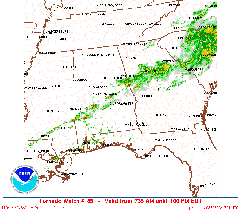
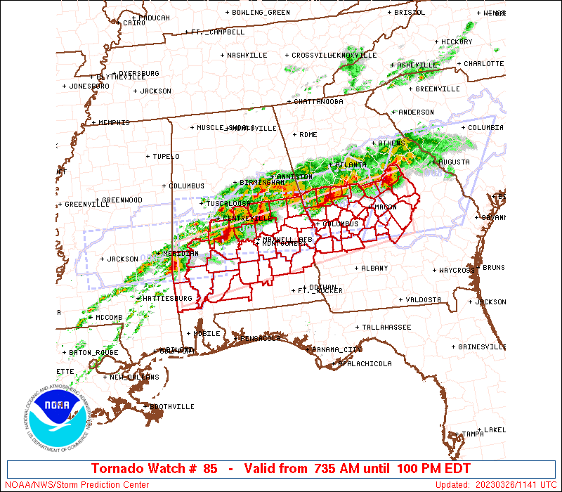
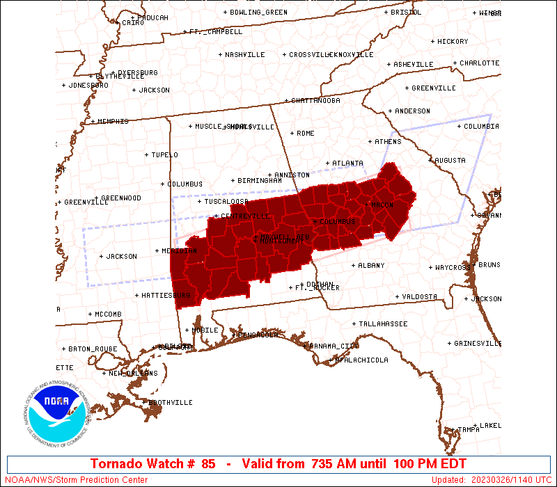
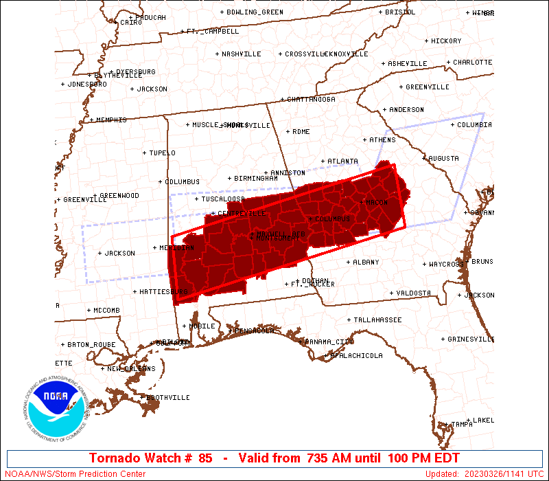
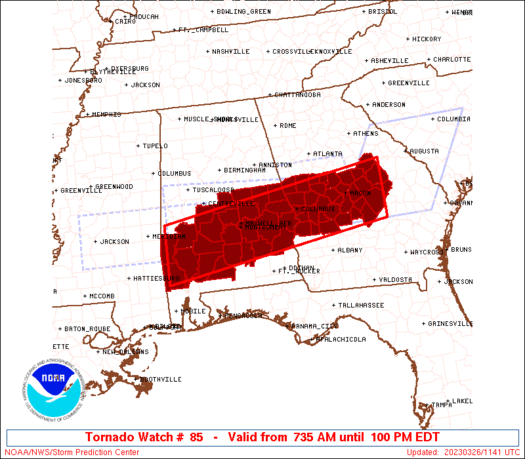
Tornado Watch Number 85
NWS Storm Prediction Center Norman OK
735 AM EDT Sun Mar 26 2023
The NWS Storm Prediction Center has issued a
* Tornado Watch for portions of
Central and southern Alabama
Central Georgia
* Effective this Sunday morning and afternoon from 735 AM until
100 PM EDT.
* Primary threats include...
A couple intense tornadoes possible
Scattered large hail and isolated very large hail events to 2.5
inches in diameter possible
Isolated damaging wind gusts to 70 mph possible
SUMMARY...Longer-lived supercells will pose a threat for tornadoes
and very large hail through midday.
The tornado watch area is approximately along and 45 statute miles
north and south of a line from 55 miles east of Macon GA to 85 miles
west southwest of Selma AL. For a complete depiction of the watch
see the associated watch outline update (WOUS64 KWNS WOU5).
PRECAUTIONARY/PREPAREDNESS ACTIONS...
REMEMBER...A Tornado Watch means conditions are favorable for
tornadoes and severe thunderstorms in and close to the watch
area. Persons in these areas should be on the lookout for
threatening weather conditions and listen for later statements
and possible warnings.
&&
OTHER WATCH INFORMATION...CONTINUE...WW 81...WW 82...WW 83...WW
84...
AVIATION...Tornadoes and a few severe thunderstorms with hail
surface and aloft to 2.5 inches. Extreme turbulence and surface wind
gusts to 60 knots. A few cumulonimbi with maximum tops to 500. Mean
storm motion vector 28035.
...Grams
 Note:
The Aviation Watch (SAW) product is an approximation to the watch area.
The actual watch is depicted by the shaded areas.
Note:
The Aviation Watch (SAW) product is an approximation to the watch area.
The actual watch is depicted by the shaded areas.
   SAW5
   WW 85 TORNADO AL GA 261135Z - 261700Z
   AXIS..45 STATUTE MILES NORTH AND SOUTH OF LINE..
   55E MCN/MACON GA/ - 85WSW SEM/SELMA AL/
   ..AVIATION COORDS.. 40NM N/S /48E MCN - 39SE MEI/
   HAIL SURFACE AND ALOFT..2.5 INCHES. WIND GUSTS..60 KNOTS.
   MAX TOPS TO 500. MEAN STORM MOTION VECTOR 28035.

   LAT...LON 32058270 31228832 32528832 33348270

   THIS IS AN APPROXIMATION TO THE WATCH AREA.  FOR A
   COMPLETE DEPICTION OF THE WATCH SEE WOUS64 KWNS
   FOR WOU5.
Watch 85 Status Report Messages:
STATUS REPORT #2 ON WW 85

VALID 261630Z - 261740Z

SEVERE WEATHER THREAT CONTINUES RIGHT OF A LINE FROM 20 SSE MEI
TO 15 NNW SEM TO 30 NNE LGC.

FOR ADDITIONAL INFORMATION SEE MESOSCALE DISCUSSION 355

..MOORE..03/26/23

ATTN...WFO...BMX...MOB...FFC...

&&

STATUS REPORT FOR WT 85

SEVERE WEATHER THREAT CONTINUES FOR THE FOLLOWING AREAS

ALC001-013-017-023-025-035-041-047-051-081-085-087-091-099-101-
123-129-131-261740-

AL
.    ALABAMA COUNTIES INCLUDED ARE

AUTAUGA 	     BUTLER		 CHAMBERS
CHOCTAW 	     CLARKE		 CONECUH
CRENSHAW	     DALLAS		 ELMORE
LEE		     LOWNDES		 MACON
MARENGO 	     MONROE		 MONTGOMERY
TALLAPOOSA	     WASHINGTON 	 WILCOX
$$


GAC009-021-023-079-141-145-153-167-169-171-175-199-207-215-225-
231-263-269-285-289-293-303-319-261740-

GA
.    GEORGIA COUNTIES INCLUDED ARE

BALDWIN 	     BIBB		 BLECKLEY
CRAWFORD	     HANCOCK		 HARRIS
HOUSTON 	     JOHNSON		 JONES
LAMAR		     LAURENS		 MERIWETHER
MONROE		     MUSCOGEE		 PEACH
PIKE		     TALBOT		 TAYLOR
TROUP		     TWIGGS		 UPSON
WASHINGTON	     WILKINSON
$$


THE WATCH STATUS MESSAGE IS FOR GUIDANCE PURPOSES ONLY.  PLEASE
REFER TO WATCH COUNTY NOTIFICATION STATEMENTS FOR OFFICIAL
INFORMATION ON COUNTIES...INDEPENDENT CITIES AND MARINE ZONES
CLEARED FROM SEVERE THUNDERSTORM AND TORNADO WATCHES.
$$

STATUS REPORT #1 ON WW 85

VALID 261530Z - 261640Z

SEVERE WEATHER THREAT CONTINUES RIGHT OF A LINE FROM 15 WNW VDI
TO 20 SSE AUO TO 40 SSW TOI.

FOR ADDITIONAL INFORMATION SEE MESOSCALE DISCUSSION 353

..MOORE..03/26/23

ATTN...WFO...BMX...MOB...FFC...

&&

STATUS REPORT FOR WT 85

SEVERE WEATHER THREAT CONTINUES FOR THE FOLLOWING AREAS

ALC001-013-017-021-023-025-035-037-041-047-051-081-085-087-091-
099-101-105-123-129-131-261640-

AL
.    ALABAMA COUNTIES INCLUDED ARE

AUTAUGA 	     BUTLER		 CHAMBERS
CHILTON 	     CHOCTAW		 CLARKE
CONECUH 	     COOSA		 CRENSHAW
DALLAS		     ELMORE		 LEE
LOWNDES 	     MACON		 MARENGO
MONROE		     MONTGOMERY 	 PERRY
TALLAPOOSA	     WASHINGTON 	 WILCOX
$$


GAC009-021-023-079-141-145-153-167-169-171-175-199-207-215-225-
231-263-269-285-289-293-303-319-261640-

GA
.    GEORGIA COUNTIES INCLUDED ARE

BALDWIN 	     BIBB		 BLECKLEY
CRAWFORD	     HANCOCK		 HARRIS
HOUSTON 	     JOHNSON		 JONES
LAMAR		     LAURENS		 MERIWETHER
MONROE		     MUSCOGEE		 PEACH
PIKE		     TALBOT		 TAYLOR
TROUP		     TWIGGS		 UPSON
WASHINGTON	     WILKINSON
$$


THE WATCH STATUS MESSAGE IS FOR GUIDANCE PURPOSES ONLY.  PLEASE
REFER TO WATCH COUNTY NOTIFICATION STATEMENTS FOR OFFICIAL
INFORMATION ON COUNTIES...INDEPENDENT CITIES AND MARINE ZONES
CLEARED FROM SEVERE THUNDERSTORM AND TORNADO WATCHES.
$$
Note:
Click for Complete Product Text.
Tornadoes
Probability of 2 or more tornadoes
|
Mod (40%)
|
Probability of 1 or more strong (EF2-EF5) tornadoes
|
Mod (30%)
|
Wind
Probability of 10 or more severe wind events
|
Mod (30%)
|
Probability of 1 or more wind events > 65 knots
|
Low (20%)
|
Hail
Probability of 10 or more severe hail events
|
Mod (40%)
|
Probability of 1 or more hailstones > 2 inches
|
Mod (40%)
|
Combined Severe Hail/Wind
Probability of 6 or more combined severe hail/wind events
|
High (70%)
|
For each watch, probabilities for particular events inside the watch
(listed above in each table) are determined by the issuing forecaster.
The "Low" category contains probability values ranging from less than 2%
to 20% (EF2-EF5 tornadoes), less than 5% to 20% (all other probabilities),
"Moderate" from 30% to 60%, and "High" from 70% to greater than 95%.
High values are bolded and lighter in color to provide awareness of
an increased threat for a particular event.


 @NWSSPC