Note:
The expiration time in the watch graphic is amended if the watch is
replaced, cancelled or extended.
Note:
Note:
The expiration time in the watch graphic is amended if the watch is
replaced, cancelled or extended.
Note: Click for
Watch Status Reports.
SEL3
URGENT - IMMEDIATE BROADCAST REQUESTED
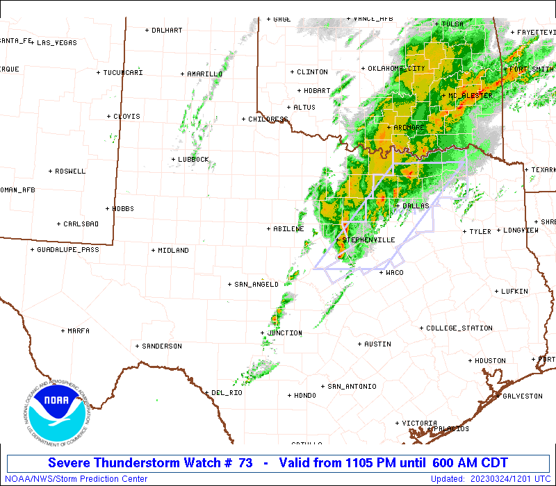
Severe Thunderstorm Watch Number 73
NWS Storm Prediction Center Norman OK
1105 PM CDT Thu Mar 23 2023
The NWS Storm Prediction Center has issued a
* Severe Thunderstorm Watch for portions of
South central Oklahoma
The Edwards Plateau into northwest Texas
* Effective this Thursday night and Friday morning from 1105 PM
until 600 AM CDT.
* Primary threats include...
Scattered large hail events to 1.5 inches in diameter possible
Isolated damaging wind gusts to 65 mph possible
SUMMARY...Isolated severe storms, some with supercell structures and
the potential for large hail, will be possible through about 1 am
CDT from northwest Texas into south central Oklahoma. Additional
storm development is expected southward toward San Angelo after 1 am
CDT, and these storms will spread eastward through the early morning
hours with an attendant threat for isolated large hail and damaging
gusts.
The severe thunderstorm watch area is approximately along and 60
statute miles east and west of a line from 40 miles east northeast
of Wichita Falls TX to 45 miles west southwest of Junction TX. For a
complete depiction of the watch see the associated watch outline
update (WOUS64 KWNS WOU3).
PRECAUTIONARY/PREPAREDNESS ACTIONS...
REMEMBER...A Severe Thunderstorm Watch means conditions are
favorable for severe thunderstorms in and close to the watch area.
Persons in these areas should be on the lookout for threatening
weather conditions and listen for later statements and possible
warnings. Severe thunderstorms can and occasionally do produce
tornadoes.
&&
AVIATION...A few severe thunderstorms with hail surface and aloft to
1.5 inches. Extreme turbulence and surface wind gusts to 55 knots. A
few cumulonimbi with maximum tops to 450. Mean storm motion vector
25030.
...Thompson

   SEL3

   URGENT - IMMEDIATE BROADCAST REQUESTED
   Severe Thunderstorm Watch Number 73
   NWS Storm Prediction Center Norman OK
   1105 PM CDT Thu Mar 23 2023

   The NWS Storm Prediction Center has issued a

   * Severe Thunderstorm Watch for portions of
     South central Oklahoma
     The Edwards Plateau into northwest Texas

   * Effective this Thursday night and Friday morning from 1105 PM
     until 600 AM CDT.

   * Primary threats include...
     Scattered large hail events to 1.5 inches in diameter possible
     Isolated damaging wind gusts to 65 mph possible

   SUMMARY...Isolated severe storms, some with supercell structures and
   the potential for large hail, will be possible through about 1 am
   CDT from northwest Texas into south central Oklahoma.  Additional
   storm development is expected southward toward San Angelo after 1 am
   CDT, and these storms will spread eastward through the early morning
   hours with an attendant threat for isolated large hail and damaging
   gusts.

   The severe thunderstorm watch area is approximately along and 60
   statute miles east and west of a line from 40 miles east northeast
   of Wichita Falls TX to 45 miles west southwest of Junction TX. For a
   complete depiction of the watch see the associated watch outline
   update (WOUS64 KWNS WOU3).

   PRECAUTIONARY/PREPAREDNESS ACTIONS...

   REMEMBER...A Severe Thunderstorm Watch means conditions are
   favorable for severe thunderstorms in and close to the watch area.
   Persons in these areas should be on the lookout for threatening
   weather conditions and listen for later statements and possible
   warnings. Severe thunderstorms can and occasionally do produce
   tornadoes.

   &&

   AVIATION...A few severe thunderstorms with hail surface and aloft to
   1.5 inches. Extreme turbulence and surface wind gusts to 55 knots. A
   few cumulonimbi with maximum tops to 450. Mean storm motion vector
   25030.

   ...Thompson
 Note:
The Aviation Watch (SAW) product is an approximation to the watch area.
The actual watch is depicted by the shaded areas.
Note:
The Aviation Watch (SAW) product is an approximation to the watch area.
The actual watch is depicted by the shaded areas.
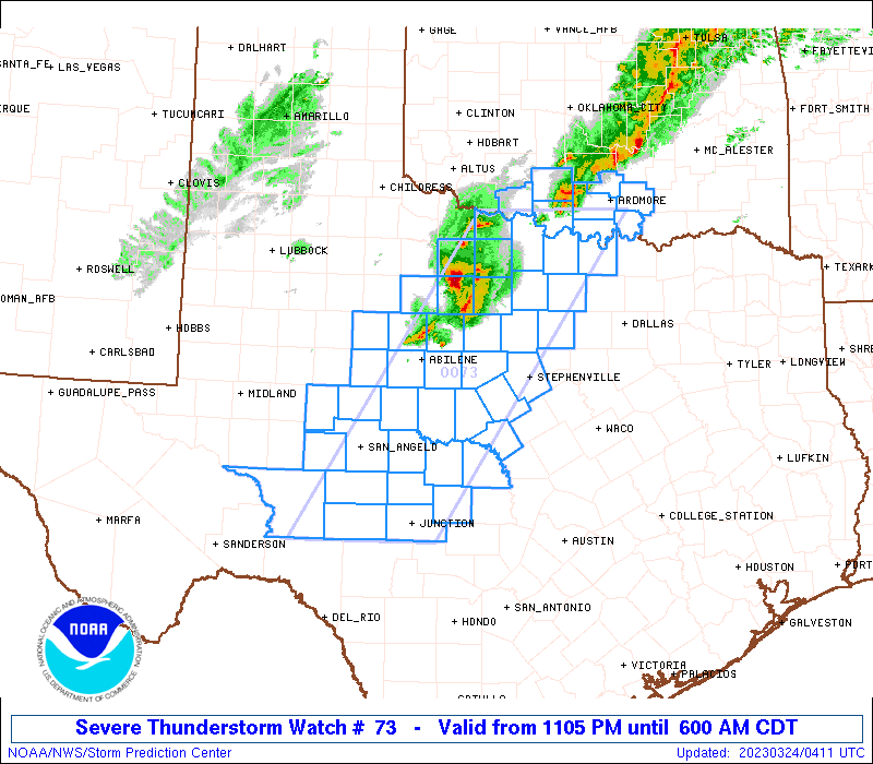
   SAW3
   WW 73 SEVERE TSTM OK TX 240405Z - 241100Z
   AXIS..60 STATUTE MILES EAST AND WEST OF LINE..
   40ENE SPS/WICHITA FALLS TX/ - 45WSW JCT/JUNCTION TX/
   ..AVIATION COORDS.. 50NM E/W /34W ADM - 39WSW JCT/
   HAIL SURFACE AND ALOFT..1.5 INCHES. WIND GUSTS..55 KNOTS.
   MAX TOPS TO 450. MEAN STORM MOTION VECTOR 25030.

   LAT...LON 34189680 30279946 30270147 34189890

   THIS IS AN APPROXIMATION TO THE WATCH AREA.  FOR A
   COMPLETE DEPICTION OF THE WATCH SEE WOUS64 KWNS
   FOR WOU3.
Watch 73 Status Report Messages:
STATUS REPORT #4 ON WW 73

VALID 241050Z - 241140Z

SEVERE WEATHER THREAT CONTINUES RIGHT OF A LINE FROM 35 WSW JCT
TO 20 W BWD TO 20 NE MWL TO 5 SSE ADM.

..GOSS..03/24/23

ATTN...WFO...OUN...SJT...FWD...

&&

STATUS REPORT FOR WS 73

SEVERE WEATHER THREAT CONTINUES FOR THE FOLLOWING AREAS

OKC005-013-069-095-241140-

OK
.    OKLAHOMA COUNTIES INCLUDED ARE

ATOKA		     BRYAN		 JOHNSTON
MARSHALL
$$


TXC049-093-097-143-267-307-319-327-333-367-411-497-241140-

TX
.    TEXAS COUNTIES INCLUDED ARE

BROWN		     COMANCHE		 COOKE
ERATH		     KIMBLE		 MCCULLOCH
MASON		     MENARD		 MILLS
PARKER		     SAN SABA		 WISE
$$


THE WATCH STATUS MESSAGE IS FOR GUIDANCE PURPOSES ONLY.  PLEASE
REFER TO WATCH COUNTY NOTIFICATION STATEMENTS FOR OFFICIAL
INFORMATION ON COUNTIES...INDEPENDENT CITIES AND MARINE ZONES
CLEARED FROM SEVERE THUNDERSTORM AND TORNADO WATCHES.
$$

STATUS REPORT #3 ON WW 73

VALID 241000Z - 241140Z

SEVERE WEATHER THREAT CONTINUES RIGHT OF A LINE FROM 55 N DRT TO
25 E SJT TO 45 WNW SEP TO 35 W ADM.

..GOSS..03/24/23

ATTN...WFO...OUN...SJT...FWD...

&&

STATUS REPORT FOR WS 73

SEVERE WEATHER THREAT CONTINUES FOR THE FOLLOWING AREAS

OKC005-013-019-067-069-085-095-099-137-241140-

OK
.    OKLAHOMA COUNTIES INCLUDED ARE

ATOKA		     BRYAN		 CARTER
JEFFERSON	     JOHNSTON		 LOVE
MARSHALL	     MURRAY		 STEPHENS
$$


TXC049-083-093-095-097-133-143-237-267-307-319-327-333-337-363-
367-411-435-497-241140-

TX
.    TEXAS COUNTIES INCLUDED ARE

BROWN		     COLEMAN		 COMANCHE
CONCHO		     COOKE		 EASTLAND
ERATH		     JACK		 KIMBLE
MCCULLOCH	     MASON		 MENARD
MILLS		     MONTAGUE		 PALO PINTO
PARKER		     SAN SABA		 SUTTON
WISE
$$


THE WATCH STATUS MESSAGE IS FOR GUIDANCE PURPOSES ONLY.  PLEASE
REFER TO WATCH COUNTY NOTIFICATION STATEMENTS FOR OFFICIAL
INFORMATION ON COUNTIES...INDEPENDENT CITIES AND MARINE ZONES
CLEARED FROM SEVERE THUNDERSTORM AND TORNADO WATCHES.
$$

STATUS REPORT #2 ON WW 73

VALID 240855Z - 240940Z

SEVERE WEATHER THREAT CONTINUES RIGHT OF A LINE FROM 60 ENE 6R6
TO 50 SSW SPS TO 35 ENE SPS.

..GOSS..03/24/23

ATTN...WFO...OUN...SJT...FWD...

&&

STATUS REPORT FOR WS 73

SEVERE WEATHER THREAT CONTINUES FOR THE FOLLOWING AREAS

OKC005-013-019-033-067-069-085-095-099-137-240940-

OK
.    OKLAHOMA COUNTIES INCLUDED ARE

ATOKA		     BRYAN		 CARTER
COTTON		     JEFFERSON		 JOHNSTON
LOVE		     MARSHALL		 MURRAY
STEPHENS
$$


TXC009-049-059-077-083-093-095-097-133-143-237-267-307-319-327-
333-337-363-367-399-411-413-417-429-435-451-485-497-503-
240940-

TX
.    TEXAS COUNTIES INCLUDED ARE

ARCHER		     BROWN		 CALLAHAN
CLAY		     COLEMAN		 COMANCHE
CONCHO		     COOKE		 EASTLAND
ERATH		     JACK		 KIMBLE
MCCULLOCH	     MASON		 MENARD
MILLS		     MONTAGUE		 PALO PINTO
PARKER		     RUNNELS		 SAN SABA
SCHLEICHER	     SHACKELFORD	 STEPHENS
SUTTON		     TOM GREEN		 WICHITA
WISE		     YOUNG
$$


THE WATCH STATUS MESSAGE IS FOR GUIDANCE PURPOSES ONLY.  PLEASE
REFER TO WATCH COUNTY NOTIFICATION STATEMENTS FOR OFFICIAL
INFORMATION ON COUNTIES...INDEPENDENT CITIES AND MARINE ZONES
CLEARED FROM SEVERE THUNDERSTORM AND TORNADO WATCHES.
$$

STATUS REPORT #1 ON WW 73

VALID 240640Z - 240740Z

THE SEVERE WEATHER THREAT CONTINUES ACROSS THE ENTIRE WATCH AREA.

..GOSS..03/24/23

ATTN...WFO...OUN...SJT...FWD...

&&

STATUS REPORT FOR WS 73

SEVERE WEATHER THREAT CONTINUES FOR THE FOLLOWING AREAS

OKC005-013-019-033-067-069-085-095-099-137-240740-

OK
.    OKLAHOMA COUNTIES INCLUDED ARE

ATOKA		     BRYAN		 CARTER
COTTON		     JEFFERSON		 JOHNSTON
LOVE		     MARSHALL		 MURRAY
STEPHENS
$$


TXC009-023-049-059-077-081-083-093-095-097-105-133-143-151-207-
235-237-253-267-307-319-327-333-337-353-363-367-399-411-413-417-
429-431-435-441-447-451-485-497-503-240740-

TX
.    TEXAS COUNTIES INCLUDED ARE

ARCHER		     BAYLOR		 BROWN
CALLAHAN	     CLAY		 COKE
COLEMAN 	     COMANCHE		 CONCHO
COOKE		     CROCKETT		 EASTLAND
ERATH		     FISHER		 HASKELL
IRION		     JACK		 JONES
KIMBLE		     MCCULLOCH		 MASON
MENARD		     MILLS		 MONTAGUE
NOLAN		     PALO PINTO 	 PARKER
RUNNELS 	     SAN SABA		 SCHLEICHER
SHACKELFORD	     STEPHENS		 STERLING
SUTTON		     TAYLOR		 THROCKMORTON
TOM GREEN	     WICHITA		 WISE
YOUNG
$$


THE WATCH STATUS MESSAGE IS FOR GUIDANCE PURPOSES ONLY.  PLEASE
REFER TO WATCH COUNTY NOTIFICATION STATEMENTS FOR OFFICIAL
INFORMATION ON COUNTIES...INDEPENDENT CITIES AND MARINE ZONES
CLEARED FROM SEVERE THUNDERSTORM AND TORNADO WATCHES.
$$
Note:
Click for Complete Product Text.
Tornadoes
Probability of 2 or more tornadoes
|
Low (10%)
|
Probability of 1 or more strong (EF2-EF5) tornadoes
|
Low (<2%)
|
Wind
Probability of 10 or more severe wind events
|
Mod (30%)
|
Probability of 1 or more wind events > 65 knots
|
Low (20%)
|
Hail
Probability of 10 or more severe hail events
|
Mod (50%)
|
Probability of 1 or more hailstones > 2 inches
|
Low (10%)
|
Combined Severe Hail/Wind
Probability of 6 or more combined severe hail/wind events
|
High (70%)
|
For each watch, probabilities for particular events inside the watch
(listed above in each table) are determined by the issuing forecaster.
The "Low" category contains probability values ranging from less than 2%
to 20% (EF2-EF5 tornadoes), less than 5% to 20% (all other probabilities),
"Moderate" from 30% to 60%, and "High" from 70% to greater than 95%.
High values are bolded and lighter in color to provide awareness of
an increased threat for a particular event.


 @NWSSPC