 Note:
The expiration time in the watch graphic is amended if the watch is
replaced, cancelled or extended.
Note:
Note:
The expiration time in the watch graphic is amended if the watch is
replaced, cancelled or extended.
Note: Click for
Watch Status Reports.
SEL2
URGENT - IMMEDIATE BROADCAST REQUESTED
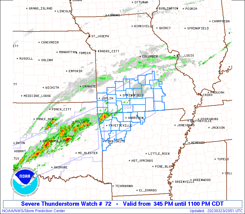
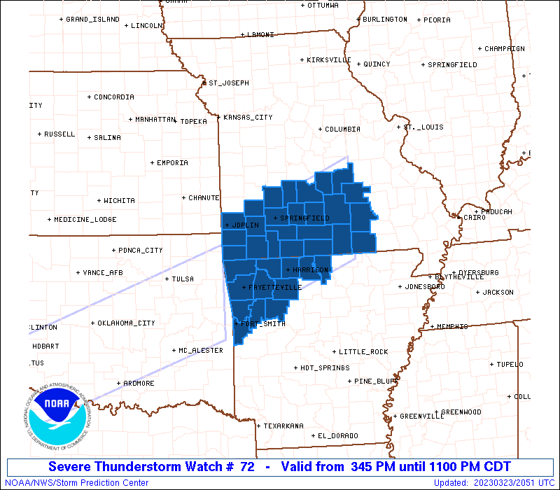
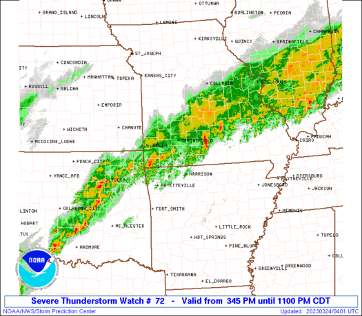
Severe Thunderstorm Watch Number 72
NWS Storm Prediction Center Norman OK
345 PM CDT Thu Mar 23 2023
The NWS Storm Prediction Center has issued a
* Severe Thunderstorm Watch for portions of
Northern Arkansas
Southern Missouri
* Effective this Thursday afternoon and evening from 345 PM until
1100 PM CDT.
* Primary threats include...
Scattered large hail and isolated very large hail events to 2
inches in diameter possible
Scattered damaging wind gusts to 65 mph possible
A tornado or two possible
SUMMARY...Storms will continue to develop across the region and
intensify through late afternoon and early evening, with these
storms focused along and to the north of a southeastward-moving cold
front. Large hail should be the most common severe hazard (aside
from locally heavy rainfall), but locally damaging winds and perhaps
a brief tornado could also occur with any storms near/south of the
cold front.
The severe thunderstorm watch area is approximately along and 65
statute miles north and south of a line from 20 miles north
northwest of Fayetteville AR to 40 miles southeast of Fort Leonard
Wood MO. For a complete depiction of the watch see the associated
watch outline update (WOUS64 KWNS WOU2).
PRECAUTIONARY/PREPAREDNESS ACTIONS...
REMEMBER...A Severe Thunderstorm Watch means conditions are
favorable for severe thunderstorms in and close to the watch area.
Persons in these areas should be on the lookout for threatening
weather conditions and listen for later statements and possible
warnings. Severe thunderstorms can and occasionally do produce
tornadoes.
&&
OTHER WATCH INFORMATION...CONTINUE...WW 71...
AVIATION...A few severe thunderstorms with hail surface and aloft to
2 inches. Extreme turbulence and surface wind gusts to 55 knots. A
few cumulonimbi with maximum tops to 500. Mean storm motion vector
24035.
...Guyer

   SEL2

   URGENT - IMMEDIATE BROADCAST REQUESTED
   Severe Thunderstorm Watch Number 72
   NWS Storm Prediction Center Norman OK
   345 PM CDT Thu Mar 23 2023

   The NWS Storm Prediction Center has issued a

   * Severe Thunderstorm Watch for portions of
     Northern Arkansas
     Southern Missouri

   * Effective this Thursday afternoon and evening from 345 PM until
     1100 PM CDT.

   * Primary threats include...
     Scattered large hail and isolated very large hail events to 2
       inches in diameter possible
     Scattered damaging wind gusts to 65 mph possible
     A tornado or two possible

   SUMMARY...Storms will continue to develop across the region and
   intensify through late afternoon and early evening, with these
   storms focused along and to the north of a southeastward-moving cold
   front. Large hail should be the most common severe hazard (aside
   from locally heavy rainfall), but locally damaging winds and perhaps
   a brief tornado could also occur with any storms near/south of the
   cold front.

   The severe thunderstorm watch area is approximately along and 65
   statute miles north and south of a line from 20 miles north
   northwest of Fayetteville AR to 40 miles southeast of Fort Leonard
   Wood MO. For a complete depiction of the watch see the associated
   watch outline update (WOUS64 KWNS WOU2).

   PRECAUTIONARY/PREPAREDNESS ACTIONS...

   REMEMBER...A Severe Thunderstorm Watch means conditions are
   favorable for severe thunderstorms in and close to the watch area.
   Persons in these areas should be on the lookout for threatening
   weather conditions and listen for later statements and possible
   warnings. Severe thunderstorms can and occasionally do produce
   tornadoes.

   &&

   OTHER WATCH INFORMATION...CONTINUE...WW 71...

   AVIATION...A few severe thunderstorms with hail surface and aloft to
   2 inches. Extreme turbulence and surface wind gusts to 55 knots. A
   few cumulonimbi with maximum tops to 500. Mean storm motion vector
   24035.

   ...Guyer
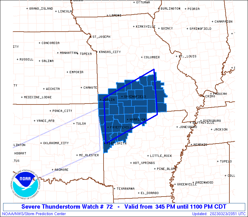
 Note:
The Aviation Watch (SAW) product is an approximation to the watch area.
The actual watch is depicted by the shaded areas.
Note:
The Aviation Watch (SAW) product is an approximation to the watch area.
The actual watch is depicted by the shaded areas.
   SAW2
   WW 72 SEVERE TSTM AR MO 232045Z - 240400Z
   AXIS..65 STATUTE MILES NORTH AND SOUTH OF LINE..
   20NNW FYV/FAYETTEVILLE AR/ - 40SE TBN/FORT LEONARD WOOD MO/
   ..AVIATION COORDS.. 55NM N/S /9W RZC - 69WSW FAM/
   HAIL SURFACE AND ALOFT..2 INCHES. WIND GUSTS..55 KNOTS.
   MAX TOPS TO 500. MEAN STORM MOTION VECTOR 24035.

   LAT...LON 37219431 38289162 36409162 35339431

   THIS IS AN APPROXIMATION TO THE WATCH AREA.  FOR A
   COMPLETE DEPICTION OF THE WATCH SEE WOUS64 KWNS
   FOR WOU2.
Watch 72 Status Report Messages:
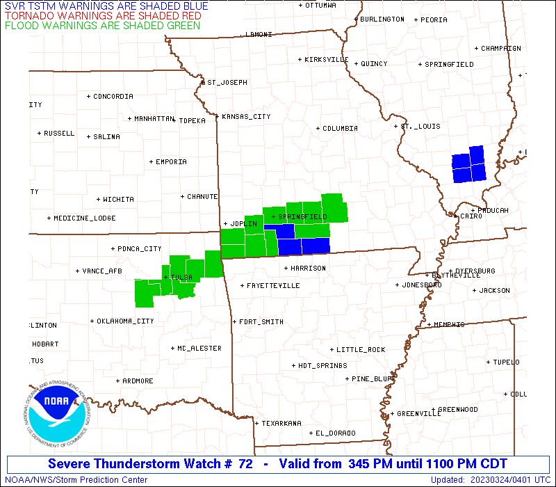
STATUS REPORT #6 ON WW 72

VALID 240320Z - 240400Z

SEVERE WEATHER THREAT CONTINUES RIGHT OF A LINE FROM 15 NNW FYV
TO 40 SE TBN.

REMAINING VALID PORTION OF WW 72 MAY BE ALLOWED TO EXPIRE AT
24/04Z.
..KERR..03/24/23

ATTN...WFO...LZK...TSA...SGF...

&&

STATUS REPORT FOR WS 72

SEVERE WEATHER THREAT CONTINUES FOR THE FOLLOWING AREAS

ARC005-009-015-033-047-071-087-089-101-131-143-240400-

AR
.    ARKANSAS COUNTIES INCLUDED ARE

BAXTER		     BOONE		 CARROLL
CRAWFORD	     FRANKLIN		 JOHNSON
MADISON 	     MARION		 NEWTON
SEBASTIAN	     WASHINGTON
$$


MOC067-091-149-153-203-213-240400-

MO
.    MISSOURI COUNTIES INCLUDED ARE

DOUGLAS 	     HOWELL		 OREGON
OZARK		     SHANNON		 TANEY
$$


THE WATCH STATUS MESSAGE IS FOR GUIDANCE PURPOSES ONLY.  PLEASE
REFER TO WATCH COUNTY NOTIFICATION STATEMENTS FOR OFFICIAL
INFORMATION ON COUNTIES...INDEPENDENT CITIES AND MARINE ZONES
CLEARED FROM SEVERE THUNDERSTORM AND TORNADO WATCHES.
$$

STATUS REPORT #5 ON WW 72

VALID 240230Z - 240340Z

SEVERE WEATHER THREAT CONTINUES RIGHT OF A LINE FROM 15 NNW FYV
TO 40 SE TBN.

..KERR..03/24/23

ATTN...WFO...LZK...TSA...SGF...

&&

STATUS REPORT FOR WS 72

SEVERE WEATHER THREAT CONTINUES FOR THE FOLLOWING AREAS

ARC005-009-015-033-047-071-087-089-101-131-143-240340-

AR
.    ARKANSAS COUNTIES INCLUDED ARE

BAXTER		     BOONE		 CARROLL
CRAWFORD	     FRANKLIN		 JOHNSON
MADISON 	     MARION		 NEWTON
SEBASTIAN	     WASHINGTON
$$


MOC067-091-149-153-203-213-240340-

MO
.    MISSOURI COUNTIES INCLUDED ARE

DOUGLAS 	     HOWELL		 OREGON
OZARK		     SHANNON		 TANEY
$$


THE WATCH STATUS MESSAGE IS FOR GUIDANCE PURPOSES ONLY.  PLEASE
REFER TO WATCH COUNTY NOTIFICATION STATEMENTS FOR OFFICIAL
INFORMATION ON COUNTIES...INDEPENDENT CITIES AND MARINE ZONES
CLEARED FROM SEVERE THUNDERSTORM AND TORNADO WATCHES.
$$

STATUS REPORT #4 ON WW 72

VALID 240130Z - 240240Z

SEVERE WEATHER THREAT CONTINUES RIGHT OF A LINE FROM 25 E GMJ TO
35 ESE TBN.

..KERR..03/24/23

ATTN...WFO...LZK...TSA...SGF...

&&

STATUS REPORT FOR WS 72

SEVERE WEATHER THREAT CONTINUES FOR THE FOLLOWING AREAS

ARC005-007-009-015-033-047-071-087-089-101-131-143-240240-

AR
.    ARKANSAS COUNTIES INCLUDED ARE

BAXTER		     BENTON		 BOONE
CARROLL 	     CRAWFORD		 FRANKLIN
JOHNSON 	     MADISON		 MARION
NEWTON		     SEBASTIAN		 WASHINGTON
$$


MOC009-043-065-067-091-149-153-203-209-213-215-229-240240-

MO
.    MISSOURI COUNTIES INCLUDED ARE

BARRY		     CHRISTIAN		 DENT
DOUGLAS 	     HOWELL		 OREGON
OZARK		     SHANNON		 STONE
TANEY		     TEXAS		 WRIGHT
$$


THE WATCH STATUS MESSAGE IS FOR GUIDANCE PURPOSES ONLY.  PLEASE
REFER TO WATCH COUNTY NOTIFICATION STATEMENTS FOR OFFICIAL
INFORMATION ON COUNTIES...INDEPENDENT CITIES AND MARINE ZONES
CLEARED FROM SEVERE THUNDERSTORM AND TORNADO WATCHES.
$$

STATUS REPORT #3 ON WW 72

VALID 240025Z - 240140Z

SEVERE WEATHER THREAT CONTINUES RIGHT OF A LINE FROM 25 E GMJ TO
35 ESE TBN.

..KERR..03/24/23

ATTN...WFO...LZK...TSA...SGF...

&&

STATUS REPORT FOR WS 72

SEVERE WEATHER THREAT CONTINUES FOR THE FOLLOWING AREAS

ARC005-007-009-015-033-047-071-087-089-101-131-143-240140-

AR
.    ARKANSAS COUNTIES INCLUDED ARE

BAXTER		     BENTON		 BOONE
CARROLL 	     CRAWFORD		 FRANKLIN
JOHNSON 	     MADISON		 MARION
NEWTON		     SEBASTIAN		 WASHINGTON
$$


MOC009-043-065-067-091-149-153-203-209-213-215-229-240140-

MO
.    MISSOURI COUNTIES INCLUDED ARE

BARRY		     CHRISTIAN		 DENT
DOUGLAS 	     HOWELL		 OREGON
OZARK		     SHANNON		 STONE
TANEY		     TEXAS		 WRIGHT
$$


THE WATCH STATUS MESSAGE IS FOR GUIDANCE PURPOSES ONLY.  PLEASE
REFER TO WATCH COUNTY NOTIFICATION STATEMENTS FOR OFFICIAL
INFORMATION ON COUNTIES...INDEPENDENT CITIES AND MARINE ZONES
CLEARED FROM SEVERE THUNDERSTORM AND TORNADO WATCHES.
$$

STATUS REPORT #2 ON WW 72

VALID 232340Z - 240040Z

SEVERE WEATHER THREAT CONTINUES RIGHT OF A LINE FROM 20 WSW UMN
TO 20 SE VIH.

..KERR..03/23/23

ATTN...WFO...LZK...TSA...SGF...

&&

STATUS REPORT FOR WS 72

SEVERE WEATHER THREAT CONTINUES FOR THE FOLLOWING AREAS

ARC005-007-009-015-033-047-071-087-089-101-131-143-240040-

AR
.    ARKANSAS COUNTIES INCLUDED ARE

BAXTER		     BENTON		 BOONE
CARROLL 	     CRAWFORD		 FRANKLIN
JOHNSON 	     MADISON		 MARION
NEWTON		     SEBASTIAN		 WASHINGTON
$$


MOC009-043-065-067-091-119-149-153-203-209-213-215-225-229-
240040-

MO
.    MISSOURI COUNTIES INCLUDED ARE

BARRY		     CHRISTIAN		 DENT
DOUGLAS 	     HOWELL		 MCDONALD
OREGON		     OZARK		 SHANNON
STONE		     TANEY		 TEXAS
WEBSTER 	     WRIGHT
$$


THE WATCH STATUS MESSAGE IS FOR GUIDANCE PURPOSES ONLY.  PLEASE
REFER TO WATCH COUNTY NOTIFICATION STATEMENTS FOR OFFICIAL
INFORMATION ON COUNTIES...INDEPENDENT CITIES AND MARINE ZONES
CLEARED FROM SEVERE THUNDERSTORM AND TORNADO WATCHES.
$$

STATUS REPORT #1 ON WW 72

VALID 232235Z - 232340Z

THE SEVERE WEATHER THREAT CONTINUES ACROSS THE ENTIRE WATCH AREA.

..KERR..03/23/23

ATTN...WFO...LZK...TSA...SGF...

&&

STATUS REPORT FOR WS 72

SEVERE WEATHER THREAT CONTINUES FOR THE FOLLOWING AREAS

ARC005-007-009-015-033-047-071-087-089-101-131-143-232340-

AR
.    ARKANSAS COUNTIES INCLUDED ARE

BAXTER		     BENTON		 BOONE
CARROLL 	     CRAWFORD		 FRANKLIN
JOHNSON 	     MADISON		 MARION
NEWTON		     SEBASTIAN		 WASHINGTON
$$


MOC009-043-057-059-065-067-077-091-097-105-109-119-145-149-153-
161-167-169-203-209-213-215-225-229-232340-

MO
.    MISSOURI COUNTIES INCLUDED ARE

BARRY		     CHRISTIAN		 DADE
DALLAS		     DENT		 DOUGLAS
GREENE		     HOWELL		 JASPER
LACLEDE 	     LAWRENCE		 MCDONALD
NEWTON		     OREGON		 OZARK
PHELPS		     POLK		 PULASKI
SHANNON 	     STONE		 TANEY
TEXAS		     WEBSTER		 WRIGHT
$$


THE WATCH STATUS MESSAGE IS FOR GUIDANCE PURPOSES ONLY.  PLEASE
REFER TO WATCH COUNTY NOTIFICATION STATEMENTS FOR OFFICIAL
INFORMATION ON COUNTIES...INDEPENDENT CITIES AND MARINE ZONES
CLEARED FROM SEVERE THUNDERSTORM AND TORNADO WATCHES.
$$
Note:
Click for Complete Product Text.
Tornadoes
Probability of 2 or more tornadoes
|
Low (20%)
|
Probability of 1 or more strong (EF2-EF5) tornadoes
|
Low (5%)
|
Wind
Probability of 10 or more severe wind events
|
Mod (40%)
|
Probability of 1 or more wind events > 65 knots
|
Low (10%)
|
Hail
Probability of 10 or more severe hail events
|
Mod (50%)
|
Probability of 1 or more hailstones > 2 inches
|
Mod (30%)
|
Combined Severe Hail/Wind
Probability of 6 or more combined severe hail/wind events
|
High (90%)
|
For each watch, probabilities for particular events inside the watch
(listed above in each table) are determined by the issuing forecaster.
The "Low" category contains probability values ranging from less than 2%
to 20% (EF2-EF5 tornadoes), less than 5% to 20% (all other probabilities),
"Moderate" from 30% to 60%, and "High" from 70% to greater than 95%.
High values are bolded and lighter in color to provide awareness of
an increased threat for a particular event.


 @NWSSPC