 Note:
The expiration time in the watch graphic is amended if the watch is
replaced, cancelled or extended.
Note:
Note:
The expiration time in the watch graphic is amended if the watch is
replaced, cancelled or extended.
Note: Click for
Watch Status Reports.
SEL0
URGENT - IMMEDIATE BROADCAST REQUESTED
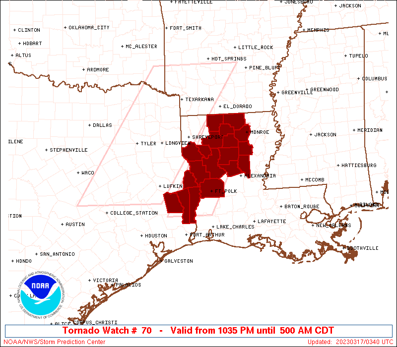
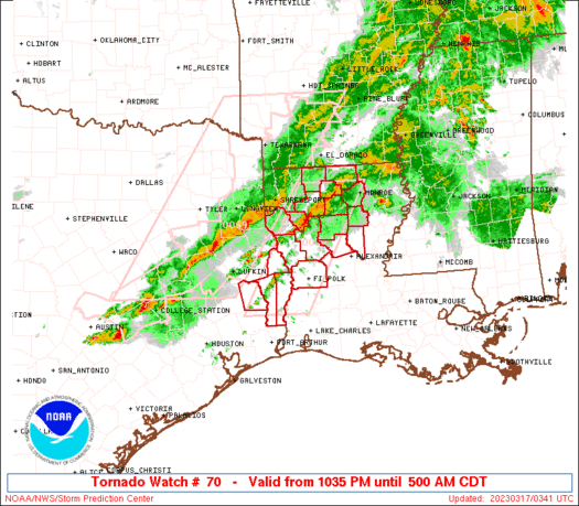
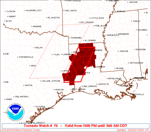
Tornado Watch Number 70
NWS Storm Prediction Center Norman OK
1035 PM CDT Thu Mar 16 2023
The NWS Storm Prediction Center has issued a
* Tornado Watch for portions of
Western Louisiana
Southeast Texas
* Effective this Thursday night and Friday morning from 1035 PM
until 500 AM CDT.
* Primary threats include...
A couple tornadoes possible
Scattered damaging wind gusts to 70 mph likely
Scattered large hail and isolated very large hail events to 2
inches in diameter possible
SUMMARY...A line of severe thunderstorms will continue moving
east-southeast through the early morning with a risk for a couple of
tornadoes, damaging winds, and isolated large hail.
The tornado watch area is approximately along and 40 statute miles
east and west of a line from 75 miles north northeast of
Natchitoches LA to 60 miles southwest of Fort Polk LA. For a
complete depiction of the watch see the associated watch outline
update (WOUS64 KWNS WOU0).
PRECAUTIONARY/PREPAREDNESS ACTIONS...
REMEMBER...A Tornado Watch means conditions are favorable for
tornadoes and severe thunderstorms in and close to the watch
area. Persons in these areas should be on the lookout for
threatening weather conditions and listen for later statements
and possible warnings.
&&
OTHER WATCH INFORMATION...CONTINUE...WW 69...
AVIATION...Tornadoes and a few severe thunderstorms with hail
surface and aloft to 2 inches. Extreme turbulence and surface wind
gusts to 60 knots. A few cumulonimbi with maximum tops to 450. Mean
storm motion vector 28035.
...Bunting
   SEL0

   URGENT - IMMEDIATE BROADCAST REQUESTED
   Tornado Watch Number 70
   NWS Storm Prediction Center Norman OK
   1035 PM CDT Thu Mar 16 2023

   The NWS Storm Prediction Center has issued a

   * Tornado Watch for portions of
     Western Louisiana
     Southeast Texas

   * Effective this Thursday night and Friday morning from 1035 PM
     until 500 AM CDT.

   * Primary threats include...
     A couple tornadoes possible
     Scattered damaging wind gusts to 70 mph likely
     Scattered large hail and isolated very large hail events to 2
       inches in diameter possible

   SUMMARY...A line of severe thunderstorms will continue moving
   east-southeast through the early morning with a risk for a couple of
   tornadoes, damaging winds, and isolated large hail.

   The tornado watch area is approximately along and 40 statute miles
   east and west of a line from 75 miles north northeast of
   Natchitoches LA to 60 miles southwest of Fort Polk LA. For a
   complete depiction of the watch see the associated watch outline
   update (WOUS64 KWNS WOU0).

   PRECAUTIONARY/PREPAREDNESS ACTIONS...

   REMEMBER...A Tornado Watch means conditions are favorable for
   tornadoes and severe thunderstorms in and close to the watch
   area. Persons in these areas should be on the lookout for
   threatening weather conditions and listen for later statements
   and possible warnings.

   &&

   OTHER WATCH INFORMATION...CONTINUE...WW 69...

   AVIATION...Tornadoes and a few severe thunderstorms with hail
   surface and aloft to 2 inches. Extreme turbulence and surface wind
   gusts to 60 knots. A few cumulonimbi with maximum tops to 450. Mean
   storm motion vector 28035.

   ...Bunting
 Note:
The Aviation Watch (SAW) product is an approximation to the watch area.
The actual watch is depicted by the shaded areas.
Note:
The Aviation Watch (SAW) product is an approximation to the watch area.
The actual watch is depicted by the shaded areas.
   SAW0
   WW 70 TORNADO LA TX 170335Z - 171000Z
   AXIS..40 STATUTE MILES EAST AND WEST OF LINE..
   75NNE IER/NATCHITOCHES LA/ - 60SW POE/FORT POLK LA/
   ..AVIATION COORDS.. 35NM E/W /32SSE ELD - 44WNW LCH/
   HAIL SURFACE AND ALOFT..2 INCHES. WIND GUSTS..60 KNOTS.
   MAX TOPS TO 450. MEAN STORM MOTION VECTOR 28035.

   LAT...LON 32749192 30439322 30439456 32749329

   THIS IS AN APPROXIMATION TO THE WATCH AREA.  FOR A
   COMPLETE DEPICTION OF THE WATCH SEE WOUS64 KWNS
   FOR WOU0.
Watch 70 Status Report Messages:
STATUS REPORT #5 ON WW 70

VALID 170820Z - 170940Z

SEVERE WEATHER THREAT CONTINUES RIGHT OF A LINE FROM 30 N BPT TO
30 S POE TO 20 SE POE.

..BROYLES..03/17/23

ATTN...WFO...SHV...LCH...

&&

STATUS REPORT FOR WT 70

SEVERE WEATHER THREAT CONTINUES FOR THE FOLLOWING AREAS

LAC003-011-079-170940-

LA
.    LOUISIANA PARISHES INCLUDED ARE

ALLEN		     BEAUREGARD 	 RAPIDES
$$


THE WATCH STATUS MESSAGE IS FOR GUIDANCE PURPOSES ONLY.  PLEASE
REFER TO WATCH COUNTY NOTIFICATION STATEMENTS FOR OFFICIAL
INFORMATION ON COUNTIES...INDEPENDENT CITIES AND MARINE ZONES
CLEARED FROM SEVERE THUNDERSTORM AND TORNADO WATCHES.
$$

STATUS REPORT #4 ON WW 70

VALID 170725Z - 170840Z

SEVERE WEATHER THREAT CONTINUES RIGHT OF A LINE FROM 35 SSE LFK
TO 15 N POE TO 15 NNW ESF.

..BROYLES..03/17/23

ATTN...WFO...SHV...LCH...

&&

STATUS REPORT FOR WT 70

SEVERE WEATHER THREAT CONTINUES FOR THE FOLLOWING AREAS

LAC003-011-059-079-115-170840-

LA
.    LOUISIANA PARISHES INCLUDED ARE

ALLEN		     BEAUREGARD 	 LA SALLE
RAPIDES 	     VERNON
$$


TXC241-351-457-170840-

TX
.    TEXAS COUNTIES INCLUDED ARE

JASPER		     NEWTON		 TYLER
$$


THE WATCH STATUS MESSAGE IS FOR GUIDANCE PURPOSES ONLY.  PLEASE
REFER TO WATCH COUNTY NOTIFICATION STATEMENTS FOR OFFICIAL
INFORMATION ON COUNTIES...INDEPENDENT CITIES AND MARINE ZONES
CLEARED FROM SEVERE THUNDERSTORM AND TORNADO WATCHES.
$$

STATUS REPORT #3 ON WW 70

VALID 170540Z - 170640Z

SEVERE WEATHER THREAT CONTINUES RIGHT OF A LINE FROM 40 ENE LFK
TO 35 NNW IER TO 20 E ELD.

..BROYLES..03/17/23

ATTN...WFO...SHV...LCH...

&&

STATUS REPORT FOR WT 70

SEVERE WEATHER THREAT CONTINUES FOR THE FOLLOWING AREAS

LAC013-021-043-049-059-061-069-073-085-111-115-127-170640-

LA
.    LOUISIANA PARISHES INCLUDED ARE

BIENVILLE	     CALDWELL		 GRANT
JACKSON 	     LA SALLE		 LINCOLN
NATCHITOCHES	     OUACHITA		 SABINE
UNION		     VERNON		 WINN
$$


TXC241-351-403-457-170640-

TX
.    TEXAS COUNTIES INCLUDED ARE

JASPER		     NEWTON		 SABINE
TYLER
$$


THE WATCH STATUS MESSAGE IS FOR GUIDANCE PURPOSES ONLY.  PLEASE
REFER TO WATCH COUNTY NOTIFICATION STATEMENTS FOR OFFICIAL
INFORMATION ON COUNTIES...INDEPENDENT CITIES AND MARINE ZONES
CLEARED FROM SEVERE THUNDERSTORM AND TORNADO WATCHES.
$$

STATUS REPORT #2 ON WW 70

VALID 170420Z - 170540Z

THE SEVERE WEATHER THREAT CONTINUES ACROSS THE ENTIRE WATCH AREA.

..DEAN..03/17/23

ATTN...WFO...SHV...LCH...

&&

STATUS REPORT FOR WT 70

SEVERE WEATHER THREAT CONTINUES FOR THE FOLLOWING AREAS

LAC013-021-027-031-043-049-059-061-069-073-081-085-111-115-127-
170540-

LA
.    LOUISIANA PARISHES INCLUDED ARE

BIENVILLE	     CALDWELL		 CLAIBORNE
DE SOTO 	     GRANT		 JACKSON
LA SALLE	     LINCOLN		 NATCHITOCHES
OUACHITA	     RED RIVER		 SABINE
UNION		     VERNON		 WINN
$$


TXC241-351-403-457-170540-

TX
.    TEXAS COUNTIES INCLUDED ARE

JASPER		     NEWTON		 SABINE
TYLER
$$


THE WATCH STATUS MESSAGE IS FOR GUIDANCE PURPOSES ONLY.  PLEASE
REFER TO WATCH COUNTY NOTIFICATION STATEMENTS FOR OFFICIAL
INFORMATION ON COUNTIES...INDEPENDENT CITIES AND MARINE ZONES
CLEARED FROM SEVERE THUNDERSTORM AND TORNADO WATCHES.
$$

STATUS REPORT #1 ON WW 70

VALID 170350Z - 170440Z

THE SEVERE WEATHER THREAT CONTINUES ACROSS THE ENTIRE WATCH AREA.

..DEAN..03/17/23

ATTN...WFO...SHV...LCH...

&&

STATUS REPORT FOR WT 70

SEVERE WEATHER THREAT CONTINUES FOR THE FOLLOWING AREAS

LAC013-021-027-031-043-049-059-061-069-073-081-085-111-115-127-
170440-

LA
.    LOUISIANA PARISHES INCLUDED ARE

BIENVILLE	     CALDWELL		 CLAIBORNE
DE SOTO 	     GRANT		 JACKSON
LA SALLE	     LINCOLN		 NATCHITOCHES
OUACHITA	     RED RIVER		 SABINE
UNION		     VERNON		 WINN
$$


TXC241-351-403-457-170440-

TX
.    TEXAS COUNTIES INCLUDED ARE

JASPER		     NEWTON		 SABINE
TYLER
$$


THE WATCH STATUS MESSAGE IS FOR GUIDANCE PURPOSES ONLY.  PLEASE
REFER TO WATCH COUNTY NOTIFICATION STATEMENTS FOR OFFICIAL
INFORMATION ON COUNTIES...INDEPENDENT CITIES AND MARINE ZONES
CLEARED FROM SEVERE THUNDERSTORM AND TORNADO WATCHES.
$$
Note:
Click for Complete Product Text.
Tornadoes
Probability of 2 or more tornadoes
|
Mod (40%)
|
Probability of 1 or more strong (EF2-EF5) tornadoes
|
Low (20%)
|
Wind
Probability of 10 or more severe wind events
|
Mod (60%)
|
Probability of 1 or more wind events > 65 knots
|
Low (20%)
|
Hail
Probability of 10 or more severe hail events
|
Mod (40%)
|
Probability of 1 or more hailstones > 2 inches
|
Mod (30%)
|
Combined Severe Hail/Wind
Probability of 6 or more combined severe hail/wind events
|
High (80%)
|
For each watch, probabilities for particular events inside the watch
(listed above in each table) are determined by the issuing forecaster.
The "Low" category contains probability values ranging from less than 2%
to 20% (EF2-EF5 tornadoes), less than 5% to 20% (all other probabilities),
"Moderate" from 30% to 60%, and "High" from 70% to greater than 95%.
High values are bolded and lighter in color to provide awareness of
an increased threat for a particular event.


 @NWSSPC