 Note:
The expiration time in the watch graphic is amended if the watch is
replaced, cancelled or extended.
Note:
Note:
The expiration time in the watch graphic is amended if the watch is
replaced, cancelled or extended.
Note: Click for
Watch Status Reports.
SEL9
URGENT - IMMEDIATE BROADCAST REQUESTED
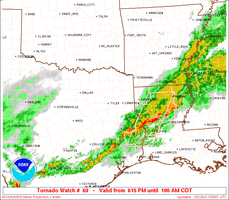
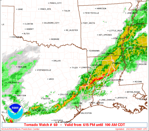
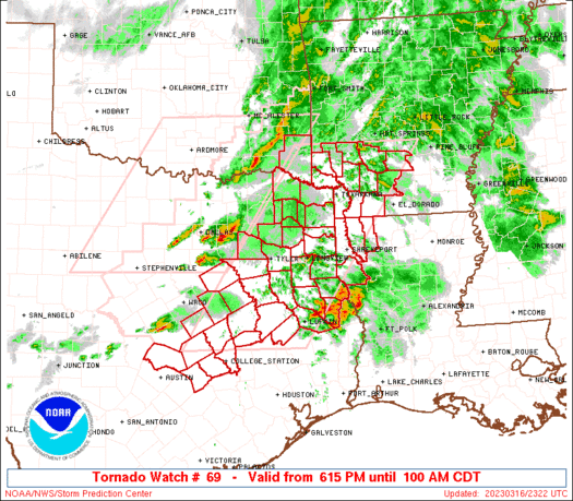
Tornado Watch Number 69
NWS Storm Prediction Center Norman OK
615 PM CDT Thu Mar 16 2023
The NWS Storm Prediction Center has issued a
* Tornado Watch for portions of
Southwest Arkansas
Northwest Louisiana
Southeast Oklahoma
Central and Eastern Texas
* Effective this Thursday night and Friday morning from 615 PM
until 100 AM CDT.
* Primary threats include...
A few tornadoes possible
Scattered large hail likely with isolated very large hail events
to 2.5 inches in diameter possible
Scattered damaging wind gusts to 70 mph likely
SUMMARY...Clusters of severe thunderstorms will eventually develop
into a line and move east and southeast across the watch area this
evening and tonight. A few tornadoes are possible, along with
damaging thunderstorm wind gusts and isolated very large hail.
The tornado watch area is approximately along and 75 statute miles
east and west of a line from 55 miles east northeast of De Queen AR
to 80 miles west southwest of Lufkin TX. For a complete depiction of
the watch see the associated watch outline update (WOUS64 KWNS
WOU9).
PRECAUTIONARY/PREPAREDNESS ACTIONS...
REMEMBER...A Tornado Watch means conditions are favorable for
tornadoes and severe thunderstorms in and close to the watch
area. Persons in these areas should be on the lookout for
threatening weather conditions and listen for later statements
and possible warnings.
&&
OTHER WATCH INFORMATION...CONTINUE...WW 68...
AVIATION...Tornadoes and a few severe thunderstorms with hail
surface and aloft to 2.5 inches. Extreme turbulence and surface wind
gusts to 60 knots. A few cumulonimbi with maximum tops to 450. Mean
storm motion vector 28035.
...Bunting
   SEL9

   URGENT - IMMEDIATE BROADCAST REQUESTED
   Tornado Watch Number 69
   NWS Storm Prediction Center Norman OK
   615 PM CDT Thu Mar 16 2023

   The NWS Storm Prediction Center has issued a

   * Tornado Watch for portions of
     Southwest Arkansas
     Northwest Louisiana
     Southeast Oklahoma
     Central and Eastern Texas

   * Effective this Thursday night and Friday morning from 615 PM
     until 100 AM CDT.

   * Primary threats include...
     A few tornadoes possible
     Scattered large hail likely with isolated very large hail events
       to 2.5 inches in diameter possible
     Scattered damaging wind gusts to 70 mph likely

   SUMMARY...Clusters of severe thunderstorms will eventually develop
   into a line and move east and southeast across the watch area this
   evening and tonight. A few tornadoes are possible, along with
   damaging thunderstorm wind gusts and isolated very large hail.

   The tornado watch area is approximately along and 75 statute miles
   east and west of a line from 55 miles east northeast of De Queen AR
   to 80 miles west southwest of Lufkin TX. For a complete depiction of
   the watch see the associated watch outline update (WOUS64 KWNS
   WOU9).

   PRECAUTIONARY/PREPAREDNESS ACTIONS...

   REMEMBER...A Tornado Watch means conditions are favorable for
   tornadoes and severe thunderstorms in and close to the watch
   area. Persons in these areas should be on the lookout for
   threatening weather conditions and listen for later statements
   and possible warnings.

   &&

   OTHER WATCH INFORMATION...CONTINUE...WW 68...

   AVIATION...Tornadoes and a few severe thunderstorms with hail
   surface and aloft to 2.5 inches. Extreme turbulence and surface wind
   gusts to 60 knots. A few cumulonimbi with maximum tops to 450. Mean
   storm motion vector 28035.

   ...Bunting
 Note:
The Aviation Watch (SAW) product is an approximation to the watch area.
The actual watch is depicted by the shaded areas.
Note:
The Aviation Watch (SAW) product is an approximation to the watch area.
The actual watch is depicted by the shaded areas.
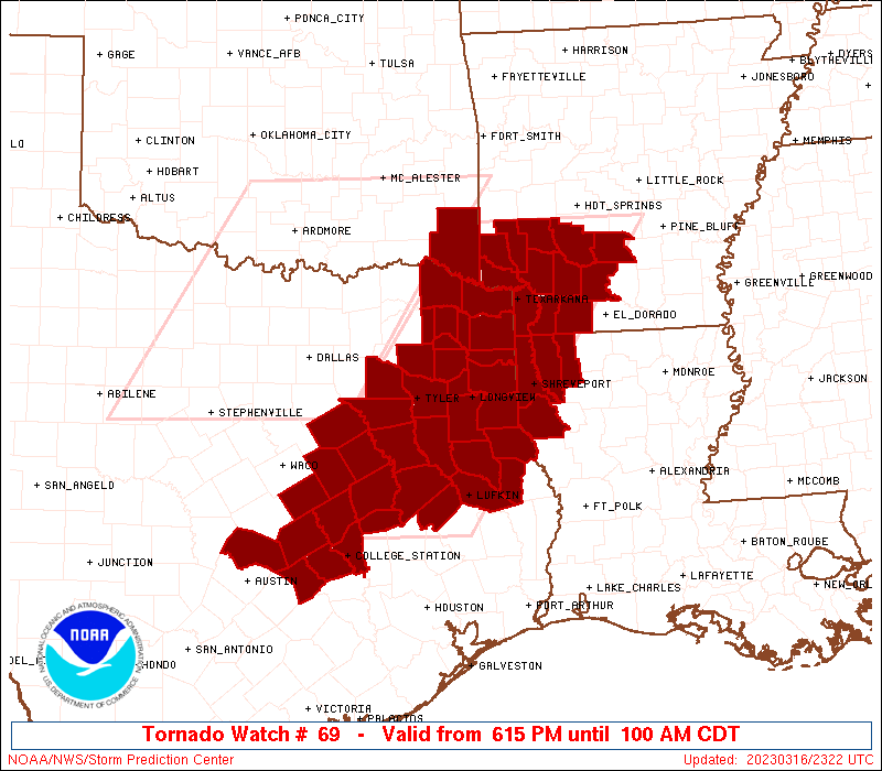
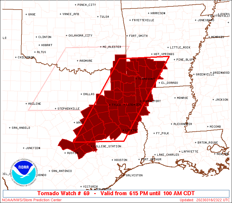
   SAW9
   WW 69 TORNADO AR LA OK TX 162315Z - 170600Z
   AXIS..75 STATUTE MILES EAST AND WEST OF LINE..
   55ENE DEQ/DE QUEEN AR/ - 80WSW LFK/LUFKIN TX/
   ..AVIATION COORDS.. 65NM E/W /58NNE TXK - 60NW IAH/
   HAIL SURFACE AND ALOFT..2.5 INCHES. WIND GUSTS..60 KNOTS.
   MAX TOPS TO 450. MEAN STORM MOTION VECTOR 28035.

   LAT...LON 34349219 30779473 30779726 34349482

   THIS IS AN APPROXIMATION TO THE WATCH AREA.  FOR A
   COMPLETE DEPICTION OF THE WATCH SEE WOUS64 KWNS
   FOR WOU9.
Watch 69 Status Report Messages:
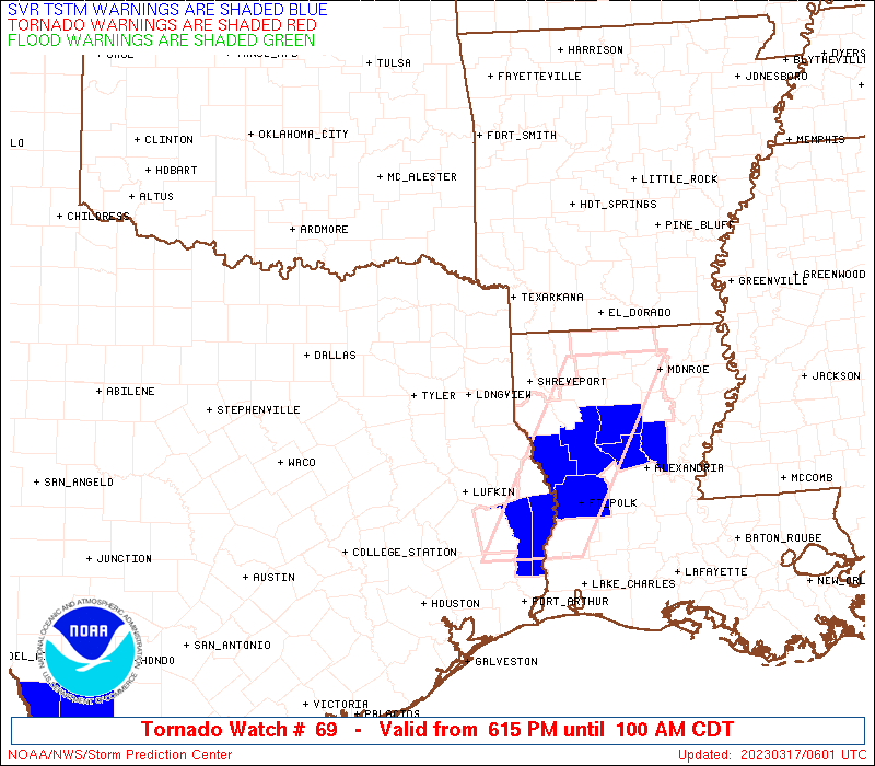
STATUS REPORT #7 ON WW 69

VALID 170425Z - 170540Z

SEVERE WEATHER THREAT CONTINUES RIGHT OF A LINE FROM 10 W CLL TO
30 NW LFK TO 15 SW SHV TO 35 ENE SHV.

..DEAN..03/17/23

ATTN...WFO...LZK...SHV...FWD...HGX...EWX...

&&

STATUS REPORT FOR WT 69

SEVERE WEATHER THREAT CONTINUES FOR THE FOLLOWING AREAS

TXC005-347-405-419-455-170540-

TX
.    TEXAS COUNTIES INCLUDED ARE

ANGELINA	     NACOGDOCHES	 SAN AUGUSTINE
SHELBY		     TRINITY
$$


THE WATCH STATUS MESSAGE IS FOR GUIDANCE PURPOSES ONLY.  PLEASE
REFER TO WATCH COUNTY NOTIFICATION STATEMENTS FOR OFFICIAL
INFORMATION ON COUNTIES...INDEPENDENT CITIES AND MARINE ZONES
CLEARED FROM SEVERE THUNDERSTORM AND TORNADO WATCHES.
$$

STATUS REPORT #6 ON WW 69

VALID 170345Z - 170440Z

SEVERE WEATHER THREAT CONTINUES RIGHT OF A LINE FROM 40 ENE AUS
TO 15 NNW SHV TO 45 SSW HOT TO 20 SSW LIT.

FOR ADDITIONAL INFORMATION SEE MESOSCALE DISCUSSION 299

..DEAN..03/17/23

ATTN...WFO...LZK...SHV...FWD...HGX...EWX...

&&

STATUS REPORT FOR WT 69

SEVERE WEATHER THREAT CONTINUES FOR THE FOLLOWING AREAS

ARC027-170440-

AR
.    ARKANSAS COUNTIES INCLUDED ARE

COLUMBIA
$$


LAC015-017-031-119-170440-

LA
.    LOUISIANA PARISHES INCLUDED ARE

BOSSIER 	     CADDO		 DE SOTO
WEBSTER
$$


NMC041-170440-

NM
.    NEW MEXICO COUNTIES INCLUDED ARE

ROOSEVELT
$$


TXC005-041-051-073-225-287-313-347-365-405-419-455-170440-

TX
.    TEXAS COUNTIES INCLUDED ARE

ANGELINA	     BRAZOS		 BURLESON
CHEROKEE	     HOUSTON		 LEE
MADISON 	     NACOGDOCHES	 PANOLA
SAN AUGUSTINE	     SHELBY		 TRINITY
$$


THE WATCH STATUS MESSAGE IS FOR GUIDANCE PURPOSES ONLY.  PLEASE
REFER TO WATCH COUNTY NOTIFICATION STATEMENTS FOR OFFICIAL
INFORMATION ON COUNTIES...INDEPENDENT CITIES AND MARINE ZONES
CLEARED FROM SEVERE THUNDERSTORM AND TORNADO WATCHES.
$$

STATUS REPORT #5 ON WW 69

VALID 170340Z - 170440Z

SEVERE WEATHER THREAT CONTINUES RIGHT OF A LINE FROM 40 ENE AUS
TO 15 NNW SHV TO 45 SSW HOT TO 20 SSW LIT.

FOR ADDITIONAL INFORMATION SEE MESOSCALE DISCUSSION 299

..DEAN..03/17/23

ATTN...WFO...LZK...SHV...FWD...HGX...EWX...

&&

STATUS REPORT FOR WT 69

SEVERE WEATHER THREAT CONTINUES FOR THE FOLLOWING AREAS

ARC019-027-039-073-099-103-170440-

AR
.    ARKANSAS COUNTIES INCLUDED ARE

CLARK		     COLUMBIA		 DALLAS
LAFAYETTE	     NEVADA		 OUACHITA
$$


LAC015-017-031-119-170440-

LA
.    LOUISIANA PARISHES INCLUDED ARE

BOSSIER 	     CADDO		 DE SOTO
WEBSTER
$$


TXC005-041-051-073-225-287-313-347-365-405-419-455-170440-

TX
.    TEXAS COUNTIES INCLUDED ARE

ANGELINA	     BRAZOS		 BURLESON
CHEROKEE	     HOUSTON		 LEE
MADISON 	     NACOGDOCHES	 PANOLA
SAN AUGUSTINE	     SHELBY		 TRINITY
$$


THE WATCH STATUS MESSAGE IS FOR GUIDANCE PURPOSES ONLY.  PLEASE
REFER TO WATCH COUNTY NOTIFICATION STATEMENTS FOR OFFICIAL
INFORMATION ON COUNTIES...INDEPENDENT CITIES AND MARINE ZONES
CLEARED FROM SEVERE THUNDERSTORM AND TORNADO WATCHES.
$$

STATUS REPORT #4 ON WW 69

VALID 170250Z - 170340Z

SEVERE WEATHER THREAT CONTINUES RIGHT OF A LINE FROM 15 SSE TPL
TO 20 W GGG TO 25 NNE TXK TO 25 W LIT.

..DEAN..03/17/23

ATTN...WFO...LZK...SHV...FWD...HGX...EWX...

&&

STATUS REPORT FOR WT 69

SEVERE WEATHER THREAT CONTINUES FOR THE FOLLOWING AREAS

ARC019-027-039-057-073-091-099-103-170340-

AR
.    ARKANSAS COUNTIES INCLUDED ARE

CLARK		     COLUMBIA		 DALLAS
HEMPSTEAD	     LAFAYETTE		 MILLER
NEVADA		     OUACHITA
$$


LAC015-017-031-119-170340-

LA
.    LOUISIANA PARISHES INCLUDED ARE

BOSSIER 	     CADDO		 DE SOTO
WEBSTER
$$


TXC001-005-041-051-067-073-161-183-203-225-287-289-313-315-331-
347-365-395-401-405-419-455-491-170340-

TX
.    TEXAS COUNTIES INCLUDED ARE

ANDERSON	     ANGELINA		 BRAZOS
BURLESON	     CASS		 CHEROKEE
FREESTONE	     GREGG		 HARRISON
HOUSTON 	     LEE		 LEON
MADISON 	     MARION		 MILAM
NACOGDOCHES	     PANOLA		 ROBERTSON
RUSK		     SAN AUGUSTINE	 SHELBY
TRINITY 	     WILLIAMSON
$$


THE WATCH STATUS MESSAGE IS FOR GUIDANCE PURPOSES ONLY.  PLEASE
REFER TO WATCH COUNTY NOTIFICATION STATEMENTS FOR OFFICIAL
INFORMATION ON COUNTIES...INDEPENDENT CITIES AND MARINE ZONES
CLEARED FROM SEVERE THUNDERSTORM AND TORNADO WATCHES.
$$

STATUS REPORT #3 ON WW 69

VALID 170200Z - 170340Z

SEVERE WEATHER THREAT CONTINUES RIGHT OF A LINE FROM 20 WSW ACT
TO 15 ENE CRS TO 45 N TYR TO 35 W HOT.

FOR ADDITIONAL INFORMATION SEE MESOSCALE DISCUSSION 298

..DEAN..03/17/23

ATTN...WFO...LZK...SHV...FWD...HGX...EWX...

&&

STATUS REPORT FOR WT 69

SEVERE WEATHER THREAT CONTINUES FOR THE FOLLOWING AREAS

ARC019-027-039-057-061-073-081-091-099-103-109-133-170340-

AR
.    ARKANSAS COUNTIES INCLUDED ARE

CLARK		     COLUMBIA		 DALLAS
HEMPSTEAD	     HOWARD		 LAFAYETTE
LITTLE RIVER	     MILLER		 NEVADA
OUACHITA	     PIKE		 SEVIER
$$


LAC015-017-031-119-170340-

LA
.    LOUISIANA PARISHES INCLUDED ARE

BOSSIER 	     CADDO		 DE SOTO
WEBSTER
$$


TXC001-005-037-041-051-063-067-073-145-161-183-203-213-225-287-
289-293-313-315-331-343-347-365-395-401-405-419-423-449-455-459-
491-170340-

TX
.    TEXAS COUNTIES INCLUDED ARE

ANDERSON	     ANGELINA		 BOWIE
BRAZOS		     BURLESON		 CAMP
CASS		     CHEROKEE		 FALLS
FREESTONE	     GREGG		 HARRISON
HENDERSON	     HOUSTON		 LEE
LEON		     LIMESTONE		 MADISON
MARION		     MILAM		 MORRIS
NACOGDOCHES	     PANOLA		 ROBERTSON
RUSK		     SAN AUGUSTINE	 SHELBY
SMITH		     TITUS		 TRINITY
UPSHUR		     WILLIAMSON
$$


THE WATCH STATUS MESSAGE IS FOR GUIDANCE PURPOSES ONLY.  PLEASE
REFER TO WATCH COUNTY NOTIFICATION STATEMENTS FOR OFFICIAL
INFORMATION ON COUNTIES...INDEPENDENT CITIES AND MARINE ZONES
CLEARED FROM SEVERE THUNDERSTORM AND TORNADO WATCHES.
$$

STATUS REPORT #2 ON WW 69

VALID 170050Z - 170140Z

THE SEVERE WEATHER THREAT CONTINUES ACROSS THE ENTIRE WATCH AREA.

..DEAN..03/17/23

ATTN...WFO...LZK...SHV...FWD...HGX...EWX...

&&

STATUS REPORT FOR WT 69

SEVERE WEATHER THREAT CONTINUES FOR THE FOLLOWING AREAS

ARC019-027-039-057-061-073-081-091-099-103-109-133-170140-

AR
.    ARKANSAS COUNTIES INCLUDED ARE

CLARK		     COLUMBIA		 DALLAS
HEMPSTEAD	     HOWARD		 LAFAYETTE
LITTLE RIVER	     MILLER		 NEVADA
OUACHITA	     PIKE		 SEVIER
$$


LAC015-017-031-119-170140-

LA
.    LOUISIANA PARISHES INCLUDED ARE

BOSSIER 	     CADDO		 DE SOTO
WEBSTER
$$


OKC089-170140-

OK
.    OKLAHOMA COUNTIES INCLUDED ARE

MCCURTAIN
$$


TXC001-005-037-041-051-063-067-073-145-159-161-183-203-213-225-
287-289-293-313-315-331-343-347-349-365-387-395-401-405-419-423-
449-455-459-467-491-499-170140-

TX
.    TEXAS COUNTIES INCLUDED ARE

ANDERSON	     ANGELINA		 BOWIE
BRAZOS		     BURLESON		 CAMP
CASS		     CHEROKEE		 FALLS
FRANKLIN	     FREESTONE		 GREGG
HARRISON	     HENDERSON		 HOUSTON
LEE		     LEON		 LIMESTONE
MADISON 	     MARION		 MILAM
MORRIS		     NACOGDOCHES	 NAVARRO
PANOLA		     RED RIVER		 ROBERTSON
RUSK		     SAN AUGUSTINE	 SHELBY
SMITH		     TITUS		 TRINITY
UPSHUR		     VAN ZANDT		 WILLIAMSON
WOOD
$$


THE WATCH STATUS MESSAGE IS FOR GUIDANCE PURPOSES ONLY.  PLEASE
REFER TO WATCH COUNTY NOTIFICATION STATEMENTS FOR OFFICIAL
INFORMATION ON COUNTIES...INDEPENDENT CITIES AND MARINE ZONES
CLEARED FROM SEVERE THUNDERSTORM AND TORNADO WATCHES.
$$

STATUS REPORT #1 ON WW 69

VALID 162345Z - 170040Z

THE SEVERE WEATHER THREAT CONTINUES ACROSS THE ENTIRE WATCH AREA.

..DEAN..03/16/23

ATTN...WFO...LZK...SHV...FWD...HGX...EWX...

&&

STATUS REPORT FOR WT 69

SEVERE WEATHER THREAT CONTINUES FOR THE FOLLOWING AREAS

ARC019-027-039-057-061-073-081-091-099-103-109-133-170040-

AR
.    ARKANSAS COUNTIES INCLUDED ARE

CLARK		     COLUMBIA		 DALLAS
HEMPSTEAD	     HOWARD		 LAFAYETTE
LITTLE RIVER	     MILLER		 NEVADA
OUACHITA	     PIKE		 SEVIER
$$


LAC015-017-031-119-170040-

LA
.    LOUISIANA PARISHES INCLUDED ARE

BOSSIER 	     CADDO		 DE SOTO
WEBSTER
$$


OKC089-170040-

OK
.    OKLAHOMA COUNTIES INCLUDED ARE

MCCURTAIN
$$


TXC001-005-037-041-051-063-067-073-145-159-161-183-203-213-225-
287-289-293-313-315-331-343-347-349-365-387-395-401-405-419-423-
449-455-459-467-491-499-170040-

TX
.    TEXAS COUNTIES INCLUDED ARE

ANDERSON	     ANGELINA		 BOWIE
BRAZOS		     BURLESON		 CAMP
CASS		     CHEROKEE		 FALLS
FRANKLIN	     FREESTONE		 GREGG
HARRISON	     HENDERSON		 HOUSTON
LEE		     LEON		 LIMESTONE
MADISON 	     MARION		 MILAM
MORRIS		     NACOGDOCHES	 NAVARRO
PANOLA		     RED RIVER		 ROBERTSON
RUSK		     SAN AUGUSTINE	 SHELBY
SMITH		     TITUS		 TRINITY
UPSHUR		     VAN ZANDT		 WILLIAMSON
WOOD
$$


THE WATCH STATUS MESSAGE IS FOR GUIDANCE PURPOSES ONLY.  PLEASE
REFER TO WATCH COUNTY NOTIFICATION STATEMENTS FOR OFFICIAL
INFORMATION ON COUNTIES...INDEPENDENT CITIES AND MARINE ZONES
CLEARED FROM SEVERE THUNDERSTORM AND TORNADO WATCHES.
$$
Note:
Click for Complete Product Text.
Tornadoes
Probability of 2 or more tornadoes
|
Mod (50%)
|
Probability of 1 or more strong (EF2-EF5) tornadoes
|
Low (20%)
|
Wind
Probability of 10 or more severe wind events
|
Mod (60%)
|
Probability of 1 or more wind events > 65 knots
|
Low (20%)
|
Hail
Probability of 10 or more severe hail events
|
Mod (60%)
|
Probability of 1 or more hailstones > 2 inches
|
Mod (30%)
|
Combined Severe Hail/Wind
Probability of 6 or more combined severe hail/wind events
|
High (>95%)
|
For each watch, probabilities for particular events inside the watch
(listed above in each table) are determined by the issuing forecaster.
The "Low" category contains probability values ranging from less than 2%
to 20% (EF2-EF5 tornadoes), less than 5% to 20% (all other probabilities),
"Moderate" from 30% to 60%, and "High" from 70% to greater than 95%.
High values are bolded and lighter in color to provide awareness of
an increased threat for a particular event.


 @NWSSPC