 Note:
The expiration time in the watch graphic is amended if the watch is
replaced, cancelled or extended.
Note:
Note:
The expiration time in the watch graphic is amended if the watch is
replaced, cancelled or extended.
Note: Click for
Watch Status Reports.
SEL8
URGENT - IMMEDIATE BROADCAST REQUESTED
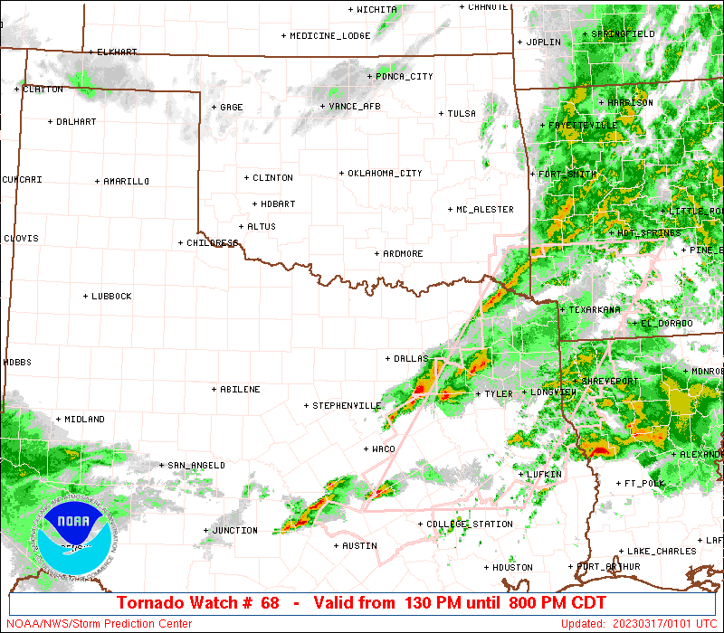
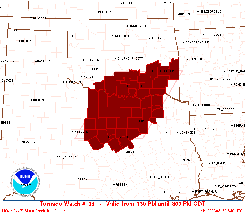
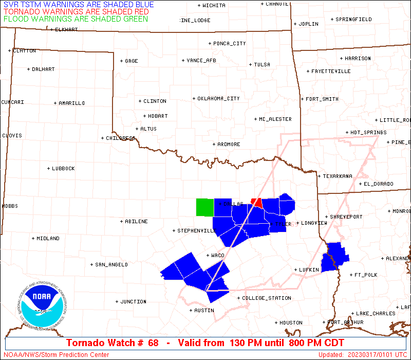
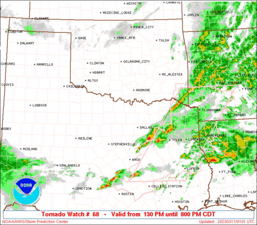
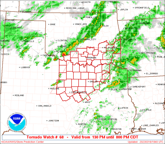
Tornado Watch Number 68
NWS Storm Prediction Center Norman OK
130 PM CDT Thu Mar 16 2023
The NWS Storm Prediction Center has issued a
* Tornado Watch for portions of
southern Oklahoma
north central Texas
* Effective this Thursday afternoon and evening from 130 PM until
800 PM CDT.
* Primary threats include...
A few tornadoes possible
Scattered large hail and isolated very large hail events to 2.5
inches in diameter likely
Scattered damaging wind gusts to 70 mph likely
SUMMARY...Thunderstorms are expected to continue to increase and
intensify across the Tornado Watch area through late afternoon. A
couple of supercells are possible early along the Red River
vicinity, and southward into portions of north central Texas, before
storms consolidate into a line or cluster while developing
east-southeastward into early evening.
The tornado watch area is approximately along and 95 statute miles
east and west of a line from 10 miles west of Mcalester OK to 15
miles east southeast of Stephenville TX. For a complete depiction of
the watch see the associated watch outline update (WOUS64 KWNS
WOU8).
PRECAUTIONARY/PREPAREDNESS ACTIONS...
REMEMBER...A Tornado Watch means conditions are favorable for
tornadoes and severe thunderstorms in and close to the watch
area. Persons in these areas should be on the lookout for
threatening weather conditions and listen for later statements
and possible warnings.
&&
AVIATION...Tornadoes and a few severe thunderstorms with hail
surface and aloft to 2.5 inches. Extreme turbulence and surface wind
gusts to 60 knots. A few cumulonimbi with maximum tops to 500. Mean
storm motion vector 25030.
...Kerr
   SEL8

   URGENT - IMMEDIATE BROADCAST REQUESTED
   Tornado Watch Number 68
   NWS Storm Prediction Center Norman OK
   130 PM CDT Thu Mar 16 2023

   The NWS Storm Prediction Center has issued a

   * Tornado Watch for portions of
     southern Oklahoma
     north central Texas

   * Effective this Thursday afternoon and evening from 130 PM until
     800 PM CDT.

   * Primary threats include...
     A few tornadoes possible
     Scattered large hail and isolated very large hail events to 2.5
       inches in diameter likely
     Scattered damaging wind gusts to 70 mph likely

   SUMMARY...Thunderstorms are expected to continue to increase and
   intensify across the Tornado Watch area through late afternoon.  A
   couple of supercells are possible early along the Red River
   vicinity, and southward into portions of north central Texas, before
   storms consolidate into a line or cluster while developing
   east-southeastward into early evening.

   The tornado watch area is approximately along and 95 statute miles
   east and west of a line from 10 miles west of Mcalester OK to 15
   miles east southeast of Stephenville TX. For a complete depiction of
   the watch see the associated watch outline update (WOUS64 KWNS
   WOU8).

   PRECAUTIONARY/PREPAREDNESS ACTIONS...

   REMEMBER...A Tornado Watch means conditions are favorable for
   tornadoes and severe thunderstorms in and close to the watch
   area. Persons in these areas should be on the lookout for
   threatening weather conditions and listen for later statements
   and possible warnings.

   &&

   AVIATION...Tornadoes and a few severe thunderstorms with hail
   surface and aloft to 2.5 inches. Extreme turbulence and surface wind
   gusts to 60 knots. A few cumulonimbi with maximum tops to 500. Mean
   storm motion vector 25030.

   ...Kerr
 Note:
The Aviation Watch (SAW) product is an approximation to the watch area.
The actual watch is depicted by the shaded areas.
Note:
The Aviation Watch (SAW) product is an approximation to the watch area.
The actual watch is depicted by the shaded areas.
   SAW8
   WW 68 TORNADO OK TX 161830Z - 170100Z
   AXIS..95 STATUTE MILES EAST AND WEST OF LINE..
   10W MLC/MCALESTER OK/ - 15ESE SEP/STEPHENVILLE TX/
   ..AVIATION COORDS.. 85NM E/W /9WNW MLC - 45NW ACT/
   HAIL SURFACE AND ALOFT..2.5 INCHES. WIND GUSTS..60 KNOTS.
   MAX TOPS TO 500. MEAN STORM MOTION VECTOR 25030.

   LAT...LON 34879428 32139632 32139957 34879763

   THIS IS AN APPROXIMATION TO THE WATCH AREA.  FOR A
   COMPLETE DEPICTION OF THE WATCH SEE WOUS64 KWNS
   FOR WOU8.
Watch 68 Status Report Messages:
STATUS REPORT #6 ON WW 68

VALID 170040Z - 170140Z

SEVERE WEATHER THREAT CONTINUES RIGHT OF A LINE FROM 20 SSW SEP
TO 40 N ACT TO 5 N PRX TO 35 S RKR TO 15 E FSM.

..DEAN..03/17/23

ATTN...WFO...OUN...TSA...FWD...

&&

STATUS REPORT FOR WT 68

SEVERE WEATHER THREAT CONTINUES FOR THE FOLLOWING AREAS

TXC027-035-099-119-139-193-217-223-231-257-277-281-309-333-379-
397-170140-

TX
.    TEXAS COUNTIES INCLUDED ARE

BELL		     BOSQUE		 CORYELL
DELTA		     ELLIS		 HAMILTON
HILL		     HOPKINS		 HUNT
KAUFMAN 	     LAMAR		 LAMPASAS
MCLENNAN	     MILLS		 RAINS
ROCKWALL
$$


THE WATCH STATUS MESSAGE IS FOR GUIDANCE PURPOSES ONLY.  PLEASE
REFER TO WATCH COUNTY NOTIFICATION STATEMENTS FOR OFFICIAL
INFORMATION ON COUNTIES...INDEPENDENT CITIES AND MARINE ZONES
CLEARED FROM SEVERE THUNDERSTORM AND TORNADO WATCHES.
$$

STATUS REPORT #5 ON WW 68

VALID 162335Z - 170040Z

SEVERE WEATHER THREAT CONTINUES RIGHT OF A LINE FROM 20 NW BWD TO
30 ENE SEP TO 25 S GYI TO 15 WNW RKR.

FOR ADDITIONAL INFORMATION SEE MESOSCALE DISCUSSION 296

..DEAN..03/16/23

ATTN...WFO...OUN...TSA...FWD...

&&

STATUS REPORT FOR WT 68

SEVERE WEATHER THREAT CONTINUES FOR THE FOLLOWING AREAS

OKC023-079-127-170040-

OK
.    OKLAHOMA COUNTIES INCLUDED ARE

CHOCTAW 	     LE FLORE		 PUSHMATAHA
$$


TXC027-035-085-093-099-113-119-139-147-193-217-223-231-251-257-
277-281-309-333-379-397-439-170040-

TX
.    TEXAS COUNTIES INCLUDED ARE

BELL		     BOSQUE		 COLLIN
COMANCHE	     CORYELL		 DALLAS
DELTA		     ELLIS		 FANNIN
HAMILTON	     HILL		 HOPKINS
HUNT		     JOHNSON		 KAUFMAN
LAMAR		     LAMPASAS		 MCLENNAN
MILLS		     RAINS		 ROCKWALL
TARRANT
$$


THE WATCH STATUS MESSAGE IS FOR GUIDANCE PURPOSES ONLY.  PLEASE
REFER TO WATCH COUNTY NOTIFICATION STATEMENTS FOR OFFICIAL
INFORMATION ON COUNTIES...INDEPENDENT CITIES AND MARINE ZONES
CLEARED FROM SEVERE THUNDERSTORM AND TORNADO WATCHES.
$$

STATUS REPORT #4 ON WW 68

VALID 162245Z - 162340Z

SEVERE WEATHER THREAT CONTINUES RIGHT OF A LINE FROM 5 SE ABI TO
10 S MWL TO 30 N FTW TO 30 SSE MKO.

FOR ADDITIONAL INFORMATION SEE MESOSCALE DISCUSSION 296

..DEAN..03/16/23

ATTN...WFO...OUN...TSA...FWD...

&&

STATUS REPORT FOR WT 68

SEVERE WEATHER THREAT CONTINUES FOR THE FOLLOWING AREAS

OKC005-013-023-077-079-127-162340-

OK
.    OKLAHOMA COUNTIES INCLUDED ARE

ATOKA		     BRYAN		 CHOCTAW
LATIMER 	     LE FLORE		 PUSHMATAHA
$$


TXC027-035-085-093-099-113-119-121-133-139-143-147-181-193-217-
221-223-231-251-257-277-281-309-333-367-379-397-425-439-
162340-

TX
.    TEXAS COUNTIES INCLUDED ARE

BELL		     BOSQUE		 COLLIN
COMANCHE	     CORYELL		 DALLAS
DELTA		     DENTON		 EASTLAND
ELLIS		     ERATH		 FANNIN
GRAYSON 	     HAMILTON		 HILL
HOOD		     HOPKINS		 HUNT
JOHNSON 	     KAUFMAN		 LAMAR
LAMPASAS	     MCLENNAN		 MILLS
PARKER		     RAINS		 ROCKWALL
SOMERVELL	     TARRANT
$$


THE WATCH STATUS MESSAGE IS FOR GUIDANCE PURPOSES ONLY.  PLEASE
REFER TO WATCH COUNTY NOTIFICATION STATEMENTS FOR OFFICIAL
INFORMATION ON COUNTIES...INDEPENDENT CITIES AND MARINE ZONES
CLEARED FROM SEVERE THUNDERSTORM AND TORNADO WATCHES.
$$

STATUS REPORT #3 ON WW 68

VALID 162145Z - 162240Z

SEVERE WEATHER THREAT CONTINUES RIGHT OF A LINE FROM 25 NE ABI TO
45 NNW FTW TO 30 WNW MLC.

FOR ADDITIONAL INFORMATION SEE MESOSCALE DISCUSSION 293

..DEAN..03/16/23

ATTN...WFO...OUN...TSA...FWD...

&&

STATUS REPORT FOR WT 68

SEVERE WEATHER THREAT CONTINUES FOR THE FOLLOWING AREAS

OKC005-013-023-029-069-077-079-085-095-121-127-162240-

OK
.    OKLAHOMA COUNTIES INCLUDED ARE

ATOKA		     BRYAN		 CHOCTAW
COAL		     JOHNSTON		 LATIMER
LE FLORE	     LOVE		 MARSHALL
PITTSBURG	     PUSHMATAHA
$$


TXC027-035-085-093-097-099-113-119-121-133-139-143-147-181-193-
217-221-223-231-237-251-257-277-281-309-333-363-367-379-397-425-
429-439-497-503-162240-

TX
.    TEXAS COUNTIES INCLUDED ARE

BELL		     BOSQUE		 COLLIN
COMANCHE	     COOKE		 CORYELL
DALLAS		     DELTA		 DENTON
EASTLAND	     ELLIS		 ERATH
FANNIN		     GRAYSON		 HAMILTON
HILL		     HOOD		 HOPKINS
HUNT		     JACK		 JOHNSON
KAUFMAN 	     LAMAR		 LAMPASAS
MCLENNAN	     MILLS		 PALO PINTO
PARKER		     RAINS		 ROCKWALL
SOMERVELL	     STEPHENS		 TARRANT
WISE		     YOUNG
$$


THE WATCH STATUS MESSAGE IS FOR GUIDANCE PURPOSES ONLY.  PLEASE
REFER TO WATCH COUNTY NOTIFICATION STATEMENTS FOR OFFICIAL
INFORMATION ON COUNTIES...INDEPENDENT CITIES AND MARINE ZONES
CLEARED FROM SEVERE THUNDERSTORM AND TORNADO WATCHES.
$$

STATUS REPORT #2 ON WW 68

VALID 162030Z - 162140Z

SEVERE WEATHER THREAT CONTINUES RIGHT OF A LINE FROM 50 SW SPS TO
15 ESE SPS TO 30 NNW ADM TO 35 WNW MLC.

FOR ADDITIONAL INFORMATION SEE MESOSCALE DISCUSSION 293.

..LEITMAN..03/16/23

ATTN...WFO...OUN...TSA...FWD...

&&

STATUS REPORT FOR WT 68

SEVERE WEATHER THREAT CONTINUES FOR THE FOLLOWING AREAS

OKC005-013-019-023-029-067-069-077-079-085-095-099-121-123-127-
162140-

OK
.    OKLAHOMA COUNTIES INCLUDED ARE

ATOKA		     BRYAN		 CARTER
CHOCTAW 	     COAL		 JEFFERSON
JOHNSTON	     LATIMER		 LE FLORE
LOVE		     MARSHALL		 MURRAY
PITTSBURG	     PONTOTOC		 PUSHMATAHA
$$


TXC009-035-077-085-093-097-113-119-121-133-139-143-147-181-217-
221-223-231-237-251-257-277-337-363-367-379-397-425-429-439-497-
503-162140-

TX
.    TEXAS COUNTIES INCLUDED ARE

ARCHER		     BOSQUE		 CLAY
COLLIN		     COMANCHE		 COOKE
DALLAS		     DELTA		 DENTON
EASTLAND	     ELLIS		 ERATH
FANNIN		     GRAYSON		 HILL
HOOD		     HOPKINS		 HUNT
JACK		     JOHNSON		 KAUFMAN
LAMAR		     MONTAGUE		 PALO PINTO
PARKER		     RAINS		 ROCKWALL
SOMERVELL	     STEPHENS		 TARRANT
WISE		     YOUNG
$$


THE WATCH STATUS MESSAGE IS FOR GUIDANCE PURPOSES ONLY.  PLEASE
REFER TO WATCH COUNTY NOTIFICATION STATEMENTS FOR OFFICIAL
INFORMATION ON COUNTIES...INDEPENDENT CITIES AND MARINE ZONES
CLEARED FROM SEVERE THUNDERSTORM AND TORNADO WATCHES.
$$

STATUS REPORT #1 ON WW 68

VALID 161925Z - 162040Z

SEVERE WEATHER THREAT CONTINUES SOUTH AND EAST OF A LINE FROM 60
WSW SPS TO 15 WNW SPS TO 15 S FSI TO 35 SSE CHK TO 35 SE OKC TO
25 SE CQB.

..FLOURNOY..03/16/23

ATTN...WFO...OUN...TSA...FWD...

&&

STATUS REPORT FOR WT 68

SEVERE WEATHER THREAT CONTINUES FOR THE FOLLOWING AREAS

OKC005-013-019-023-029-033-049-067-069-077-079-085-095-099-121-
123-127-137-162040-

OK
.    OKLAHOMA COUNTIES INCLUDED ARE

ATOKA		     BRYAN		 CARTER
CHOCTAW 	     COAL		 COTTON
GARVIN		     JEFFERSON		 JOHNSTON
LATIMER 	     LE FLORE		 LOVE
MARSHALL	     MURRAY		 PITTSBURG
PONTOTOC	     PUSHMATAHA 	 STEPHENS
$$


TXC009-035-077-085-093-097-113-119-121-133-139-143-147-181-217-
221-223-231-237-251-257-277-337-363-367-379-397-425-429-439-485-
497-503-162040-

TX
.    TEXAS COUNTIES INCLUDED ARE

ARCHER		     BOSQUE		 CLAY
COLLIN		     COMANCHE		 COOKE
DALLAS		     DELTA		 DENTON
EASTLAND	     ELLIS		 ERATH
FANNIN		     GRAYSON		 HILL
HOOD		     HOPKINS		 HUNT
JACK		     JOHNSON		 KAUFMAN
LAMAR		     MONTAGUE		 PALO PINTO
PARKER		     RAINS		 ROCKWALL
SOMERVELL	     STEPHENS		 TARRANT
WICHITA 	     WISE		 YOUNG
$$


THE WATCH STATUS MESSAGE IS FOR GUIDANCE PURPOSES ONLY.  PLEASE
REFER TO WATCH COUNTY NOTIFICATION STATEMENTS FOR OFFICIAL
INFORMATION ON COUNTIES...INDEPENDENT CITIES AND MARINE ZONES
CLEARED FROM SEVERE THUNDERSTORM AND TORNADO WATCHES.
$$
Note:
Click for Complete Product Text.
Tornadoes
Probability of 2 or more tornadoes
|
Mod (50%)
|
Probability of 1 or more strong (EF2-EF5) tornadoes
|
Low (20%)
|
Wind
Probability of 10 or more severe wind events
|
Mod (60%)
|
Probability of 1 or more wind events > 65 knots
|
Low (20%)
|
Hail
Probability of 10 or more severe hail events
|
Mod (60%)
|
Probability of 1 or more hailstones > 2 inches
|
Mod (60%)
|
Combined Severe Hail/Wind
Probability of 6 or more combined severe hail/wind events
|
High (>95%)
|
For each watch, probabilities for particular events inside the watch
(listed above in each table) are determined by the issuing forecaster.
The "Low" category contains probability values ranging from less than 2%
to 20% (EF2-EF5 tornadoes), less than 5% to 20% (all other probabilities),
"Moderate" from 30% to 60%, and "High" from 70% to greater than 95%.
High values are bolded and lighter in color to provide awareness of
an increased threat for a particular event.


 @NWSSPC