 Note:
The expiration time in the watch graphic is amended if the watch is
replaced, cancelled or extended.
Note:
Note:
The expiration time in the watch graphic is amended if the watch is
replaced, cancelled or extended.
Note: Click for
Watch Status Reports.
SEL7
URGENT - IMMEDIATE BROADCAST REQUESTED
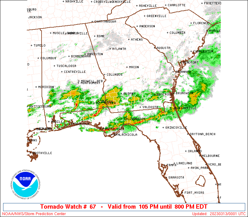
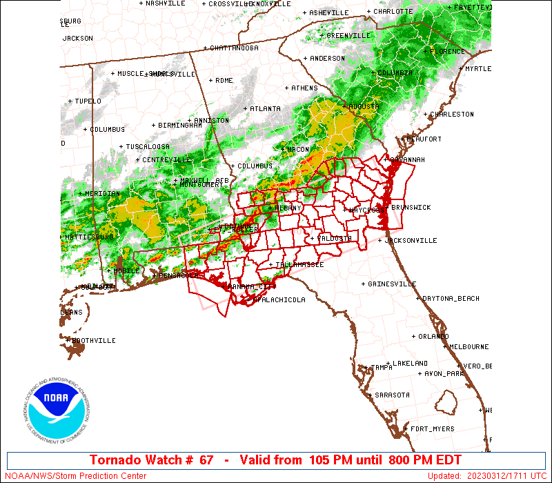
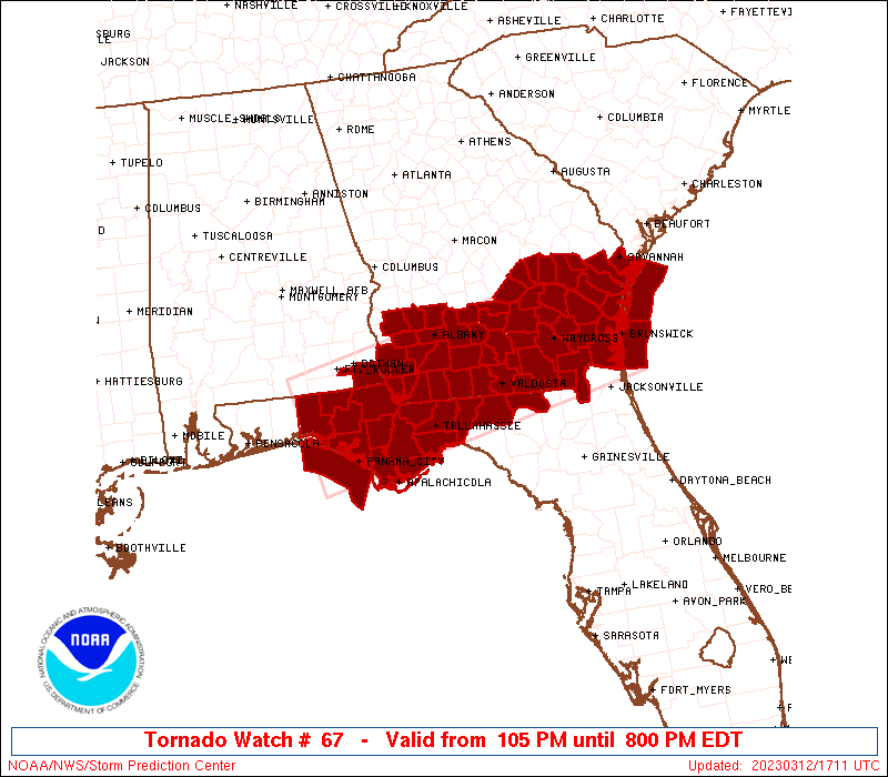
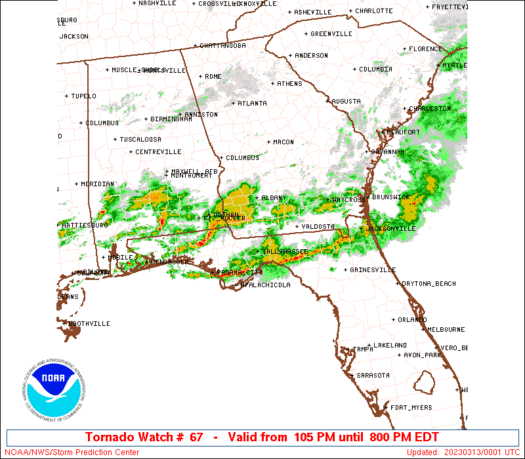
Tornado Watch Number 67
NWS Storm Prediction Center Norman OK
105 PM EDT Sun Mar 12 2023
The NWS Storm Prediction Center has issued a
* Tornado Watch for portions of
Extreme southeastern Alabama
Extreme northern Florida and Florida Panhandle
Southern Georgia
Coastal Waters
* Effective this Sunday afternoon and evening from 105 PM until
800 PM EDT.
* Primary threats include...
A couple tornadoes possible
Isolated very large hail events to 2 inches in diameter possible
Isolated damaging wind gusts to 70 mph possible
SUMMARY...Bands of thunderstorms will increase their organization
and severe potential through the afternoon, as they move eastward
into a destabilizing airmass across the watch area. Sporadic
damaging wind, large hail and a couple tornadoes are possible.
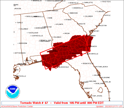
The tornado watch area is approximately along and 55 statute miles
either side of a line from 40 miles west northwest of Panama City FL
to 20 miles north northeast of Brunswick GA. For a complete
depiction of the watch see the associated watch outline update
(WOUS64 KWNS WOU7).
PRECAUTIONARY/PREPAREDNESS ACTIONS...
REMEMBER...A Tornado Watch means conditions are favorable for
tornadoes and severe thunderstorms in and close to the watch
area. Persons in these areas should be on the lookout for
threatening weather conditions and listen for later statements
and possible warnings.
&&
AVIATION...Tornadoes and a few severe thunderstorms with hail
surface and aloft to 2 inches. Extreme turbulence and surface wind
gusts to 60 knots. A few cumulonimbi with maximum tops to 500. Mean
storm motion vector 26035.
...Edwards
   SEL7

   URGENT - IMMEDIATE BROADCAST REQUESTED
   Tornado Watch Number 67
   NWS Storm Prediction Center Norman OK
   105 PM EDT Sun Mar 12 2023

   The NWS Storm Prediction Center has issued a

   * Tornado Watch for portions of
     Extreme southeastern Alabama
     Extreme northern Florida and Florida Panhandle
     Southern Georgia
     Coastal Waters

   * Effective this Sunday afternoon and evening from 105 PM until
     800 PM EDT.

   * Primary threats include...
     A couple tornadoes possible
     Isolated very large hail events to 2 inches in diameter possible
     Isolated damaging wind gusts to 70 mph possible

   SUMMARY...Bands of thunderstorms will increase their organization
   and severe potential through the afternoon, as they move eastward
   into a destabilizing airmass across the watch area.  Sporadic
   damaging wind, large hail and a couple tornadoes are possible.

   The tornado watch area is approximately along and 55 statute miles
   either side of a line from 40 miles west northwest of Panama City FL
   to 20 miles north northeast of Brunswick GA. For a complete
   depiction of the watch see the associated watch outline update
   (WOUS64 KWNS WOU7).

   PRECAUTIONARY/PREPAREDNESS ACTIONS...

   REMEMBER...A Tornado Watch means conditions are favorable for
   tornadoes and severe thunderstorms in and close to the watch
   area. Persons in these areas should be on the lookout for
   threatening weather conditions and listen for later statements
   and possible warnings.

   &&

   AVIATION...Tornadoes and a few severe thunderstorms with hail
   surface and aloft to 2 inches. Extreme turbulence and surface wind
   gusts to 60 knots. A few cumulonimbi with maximum tops to 500. Mean
   storm motion vector 26035.

   ...Edwards
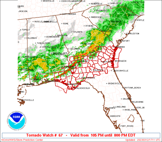
 Note:
The Aviation Watch (SAW) product is an approximation to the watch area.
The actual watch is depicted by the shaded areas.
Note:
The Aviation Watch (SAW) product is an approximation to the watch area.
The actual watch is depicted by the shaded areas.
   SAW7
   WW 67 TORNADO AL FL GA CW 121705Z - 130000Z
   AXIS..55 STATUTE MILES EITHER SIDE OF LINE..
   40WNW PFN/PANAMA CITY FL/ - 20NNE SSI/BRUNSWICK GA/
   ..AVIATION COORDS.. 50NM EITHER SIDE /31SE CEW - 46SSW SAV/
   HAIL SURFACE AND ALOFT..2 INCHES. WIND GUSTS..60 KNOTS.
   MAX TOPS TO 500. MEAN STORM MOTION VECTOR 26035.

   LAT...LON 31228649 32208151 30648112 29668612

   THIS IS AN APPROXIMATION TO THE WATCH AREA.  FOR A
   COMPLETE DEPICTION OF THE WATCH SEE WOUS64 KWNS
   FOR WOU7.
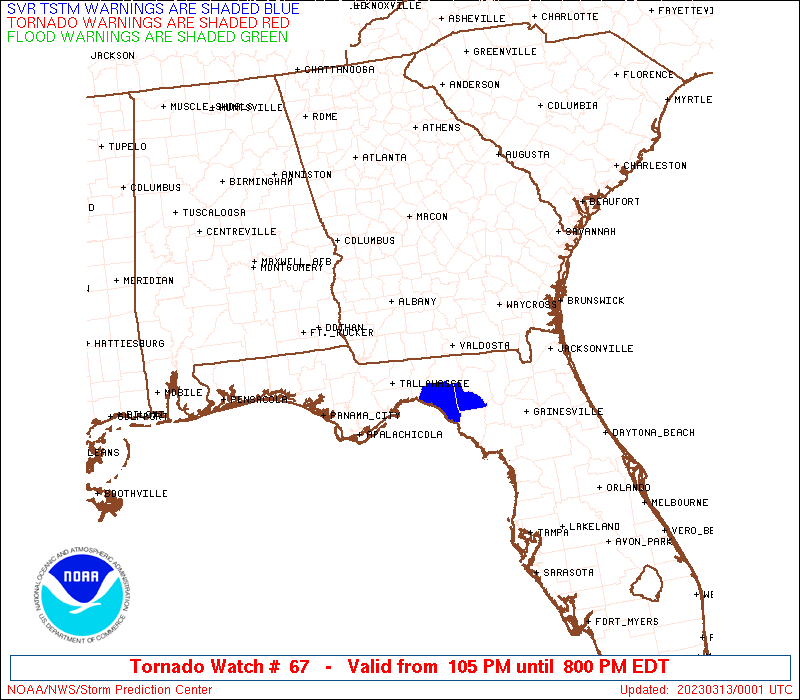
Watch 67 Status Report Messages:
STATUS REPORT #6 ON WW 67

VALID 122240Z - 122340Z

SEVERE WEATHER THREAT CONTINUES RIGHT OF A LINE FROM 30 W PFN TO
20 SE MAI TO VLD TO 30 S AYS TO 20 SW SSI TO 25 E SSI.

..LYONS..03/12/23

ATTN...WFO...TAE...JAX...CHS...FFC...

&&

STATUS REPORT FOR WT 67

SEVERE WEATHER THREAT CONTINUES FOR THE FOLLOWING AREAS

FLC003-005-023-029-031-037-045-047-065-067-073-077-079-089-121-
123-129-122340-

FL
.    FLORIDA COUNTIES INCLUDED ARE

BAKER		     BAY		 COLUMBIA
DIXIE		     DUVAL		 FRANKLIN
GULF		     HAMILTON		 JEFFERSON
LAFAYETTE	     LEON		 LIBERTY
MADISON 	     NASSAU		 SUWANNEE
TAYLOR		     WAKULLA
$$


GMZ730-750-752-755-765-122340-

CW

.    ADJACENT COASTAL WATERS INCLUDED ARE

APALACHEE BAY OR COASTAL WATERS FROM KEATON BEACH TO OCHLOCKONEE
RIVER FL OUT TO 20 NM

COASTAL WATERS FROM OKALOOSA-WALTON COUNTY LINE TO MEXICO BEACH
OUT 20 NM

COASTAL WATERS FROM MEXICO BEACH TO APALACHICOLA OUT 20 NM

COASTAL WATERS FROM  OCHLOCKONEE RIVER TO APALACHICOLA FL OUT TO
20 NM

COASTAL WATERS FROM  SUWANNEE RIVER TO KEATON BEACH OUT 20 NM

$$
THE WATCH STATUS MESSAGE IS FOR GUIDANCE PURPOSES ONLY.  PLEASE
REFER TO WATCH COUNTY NOTIFICATION STATEMENTS FOR OFFICIAL
INFORMATION ON COUNTIES...INDEPENDENT CITIES AND MARINE ZONES
CLEARED FROM SEVERE THUNDERSTORM AND TORNADO WATCHES.
$$

STATUS REPORT #5 ON WW 67

VALID 122140Z - 122240Z

SEVERE WEATHER THREAT CONTINUES RIGHT OF A LINE FROM 35 W PFN TO
25 NE PFN TO 15 NW TLH TO 15 WSW VLD TO 35 E VLD TO 15 WNW SSI TO
15 ENE SSI.

..LYONS..03/12/23

ATTN...WFO...TAE...JAX...CHS...FFC...

&&

STATUS REPORT FOR WT 67

SEVERE WEATHER THREAT CONTINUES FOR THE FOLLOWING AREAS

FLC003-005-023-029-031-037-045-047-065-067-073-077-079-089-121-
123-129-122240-

FL
.    FLORIDA COUNTIES INCLUDED ARE

BAKER		     BAY		 COLUMBIA
DIXIE		     DUVAL		 FRANKLIN
GULF		     HAMILTON		 JEFFERSON
LAFAYETTE	     LEON		 LIBERTY
MADISON 	     NASSAU		 SUWANNEE
TAYLOR		     WAKULLA
$$


GAC039-049-122240-

GA
.    GEORGIA COUNTIES INCLUDED ARE

CAMDEN		     CHARLTON
$$


GMZ730-750-752-755-765-122240-

CW

.    ADJACENT COASTAL WATERS INCLUDED ARE

APALACHEE BAY OR COASTAL WATERS FROM KEATON BEACH TO OCHLOCKONEE
RIVER FL OUT TO 20 NM

COASTAL WATERS FROM OKALOOSA-WALTON COUNTY LINE TO MEXICO BEACH
OUT 20 NM

COASTAL WATERS FROM MEXICO BEACH TO APALACHICOLA OUT 20 NM

COASTAL WATERS FROM  OCHLOCKONEE RIVER TO APALACHICOLA FL OUT TO
20 NM

COASTAL WATERS FROM  SUWANNEE RIVER TO KEATON BEACH OUT 20 NM

$$
THE WATCH STATUS MESSAGE IS FOR GUIDANCE PURPOSES ONLY.  PLEASE
REFER TO WATCH COUNTY NOTIFICATION STATEMENTS FOR OFFICIAL
INFORMATION ON COUNTIES...INDEPENDENT CITIES AND MARINE ZONES
CLEARED FROM SEVERE THUNDERSTORM AND TORNADO WATCHES.
$$

STATUS REPORT #4 ON WW 67

VALID 122040Z - 122140Z

SEVERE WEATHER THREAT CONTINUES RIGHT OF A LINE FROM 35 W PFN TO
20 NNW TLH TO 25 SSW MGR TO 20 NW VLD TO 30 W AYS TO 20 NNE AYS
TO 25 WSW SAV TO 15 WNW SAV.

FOR ADDITIONAL INFORMATION SEE MESOSCALE DISCUSSION 282

..LYONS..03/12/23

ATTN...WFO...TAE...JAX...CHS...FFC...

&&

STATUS REPORT FOR WT 67

SEVERE WEATHER THREAT CONTINUES FOR THE FOLLOWING AREAS

FLC003-005-013-023-031-037-039-045-047-065-073-077-079-089-121-
129-122140-

FL
.    FLORIDA COUNTIES INCLUDED ARE

BAKER		     BAY		 CALHOUN
COLUMBIA	     DUVAL		 FRANKLIN
GADSDEN 	     GULF		 HAMILTON
JEFFERSON	     LEON		 LIBERTY
MADISON 	     NASSAU		 SUWANNEE
WAKULLA
$$


GAC025-027-039-049-065-101-127-173-179-185-191-229-299-305-
122140-

GA
.    GEORGIA COUNTIES INCLUDED ARE

BRANTLEY	     BROOKS		 CAMDEN
CHARLTON	     CLINCH		 ECHOLS
GLYNN		     LANIER		 LIBERTY
LOWNDES 	     MCINTOSH		 PIERCE
WARE		     WAYNE
$$


AMZ354-450-GMZ750-122140-

CW

.    ADJACENT COASTAL WATERS INCLUDED ARE

COASTAL WATERS FROM SAVANNAH GA TO ALTAMAHA SOUND GA OUT 20 NM
...INCLUDING GRAYS REEF NATIONAL MARINE SANCTUARY

COASTAL WATERS FROM ALTAMAHA SOUND TO FERNANDINA BEACH FL OUT 20
NM

COASTAL WATERS FROM OKALOOSA-WALTON COUNTY LINE TO MEXICO BEACH
OUT 20 NM

$$
THE WATCH STATUS MESSAGE IS FOR GUIDANCE PURPOSES ONLY.  PLEASE
REFER TO WATCH COUNTY NOTIFICATION STATEMENTS FOR OFFICIAL
INFORMATION ON COUNTIES...INDEPENDENT CITIES AND MARINE ZONES
CLEARED FROM SEVERE THUNDERSTORM AND TORNADO WATCHES.
$$

STATUS REPORT #3 ON WW 67

VALID 121940Z - 122040Z

SEVERE WEATHER THREAT CONTINUES RIGHT OF A LINE FROM 20 SE CEW TO
20 ENE MAI TO 20 W MGR TO 15 N MGR TO 40 NE MGR TO 35 NW AYS TO
25 SW VDI TO 10 NE VDI.

..LYONS..03/12/23

ATTN...WFO...TAE...JAX...CHS...FFC...

&&

STATUS REPORT FOR WT 67

SEVERE WEATHER THREAT CONTINUES FOR THE FOLLOWING AREAS

FLC005-013-037-039-045-047-063-065-073-077-079-129-133-122040-

FL
.    FLORIDA COUNTIES INCLUDED ARE

BAY		     CALHOUN		 FRANKLIN
GADSDEN 	     GULF		 HAMILTON
JACKSON 	     JEFFERSON		 LEON
LIBERTY 	     MADISON		 WAKULLA
WASHINGTON
$$


GAC001-003-005-019-025-027-029-039-049-051-065-071-075-087-101-
109-127-131-161-173-179-183-185-191-229-253-267-275-279-299-305-
122040-

GA
.    GEORGIA COUNTIES INCLUDED ARE

APPLING 	     ATKINSON		 BACON
BERRIEN 	     BRANTLEY		 BROOKS
BRYAN		     CAMDEN		 CHARLTON
CHATHAM 	     CLINCH		 COLQUITT
COOK		     DECATUR		 ECHOLS
EVANS		     GLYNN		 GRADY
JEFF DAVIS	     LANIER		 LIBERTY
LONG		     LOWNDES		 MCINTOSH
PIERCE		     SEMINOLE		 TATTNALL
THOMAS		     TOOMBS		 WARE
WAYNE
$$


AMZ354-450-GMZ750-122040-

CW

.    ADJACENT COASTAL WATERS INCLUDED ARE

COASTAL WATERS FROM SAVANNAH GA TO ALTAMAHA SOUND GA OUT 20 NM
...INCLUDING GRAYS REEF NATIONAL MARINE SANCTUARY

COASTAL WATERS FROM ALTAMAHA SOUND TO FERNANDINA BEACH FL OUT 20
NM

COASTAL WATERS FROM OKALOOSA-WALTON COUNTY LINE TO MEXICO BEACH
OUT 20 NM

$$
THE WATCH STATUS MESSAGE IS FOR GUIDANCE PURPOSES ONLY.  PLEASE
REFER TO WATCH COUNTY NOTIFICATION STATEMENTS FOR OFFICIAL
INFORMATION ON COUNTIES...INDEPENDENT CITIES AND MARINE ZONES
CLEARED FROM SEVERE THUNDERSTORM AND TORNADO WATCHES.
$$

STATUS REPORT #2 ON WW 67

VALID 121840Z - 121940Z

SEVERE WEATHER THREAT CONTINUES RIGHT OF A LINE FROM 15 NE CEW TO
15 NNW MAI TO 10 SW ABY TO 20 E ABY TO 40 NE ABY.

FOR ADDITIONAL INFORMATION SEE MESOSCALE DISCUSSION 281

..LYONS..03/12/23

ATTN...WFO...TAE...JAX...CHS...FFC...

&&

STATUS REPORT FOR WT 67

SEVERE WEATHER THREAT CONTINUES FOR THE FOLLOWING AREAS

FLC005-013-037-039-045-047-059-063-065-073-077-079-129-131-133-
121940-

FL
.    FLORIDA COUNTIES INCLUDED ARE

BAY		     CALHOUN		 FRANKLIN
GADSDEN 	     GULF		 HAMILTON
HOLMES		     JACKSON		 JEFFERSON
LEON		     LIBERTY		 MADISON
WAKULLA 	     WALTON		 WASHINGTON
$$


GAC001-003-005-007-017-019-025-027-029-039-049-051-065-069-071-
075-087-101-109-127-131-155-161-173-179-183-185-191-201-205-209-
229-253-267-271-275-277-279-287-299-305-309-321-121940-

GA
.    GEORGIA COUNTIES INCLUDED ARE

APPLING 	     ATKINSON		 BACON
BAKER		     BEN HILL		 BERRIEN
BRANTLEY	     BROOKS		 BRYAN
CAMDEN		     CHARLTON		 CHATHAM
CLINCH		     COFFEE		 COLQUITT
COOK		     DECATUR		 ECHOLS
EVANS		     GLYNN		 GRADY
IRWIN		     JEFF DAVIS 	 LANIER
LIBERTY 	     LONG		 LOWNDES
MCINTOSH	     MILLER		 MITCHELL
MONTGOMERY	     PIERCE		 SEMINOLE
TATTNALL	     TELFAIR		 THOMAS
TIFT		     TOOMBS		 TURNER
WARE		     WAYNE		 WHEELER
WORTH
$$


AMZ354-450-GMZ750-121940-

CW

.    ADJACENT COASTAL WATERS INCLUDED ARE

COASTAL WATERS FROM SAVANNAH GA TO ALTAMAHA SOUND GA OUT 20 NM
...INCLUDING GRAYS REEF NATIONAL MARINE SANCTUARY

COASTAL WATERS FROM ALTAMAHA SOUND TO FERNANDINA BEACH FL OUT 20
NM

COASTAL WATERS FROM OKALOOSA-WALTON COUNTY LINE TO MEXICO BEACH
OUT 20 NM

$$
THE WATCH STATUS MESSAGE IS FOR GUIDANCE PURPOSES ONLY.  PLEASE
REFER TO WATCH COUNTY NOTIFICATION STATEMENTS FOR OFFICIAL
INFORMATION ON COUNTIES...INDEPENDENT CITIES AND MARINE ZONES
CLEARED FROM SEVERE THUNDERSTORM AND TORNADO WATCHES.
$$

STATUS REPORT #1 ON WW 67

VALID 121735Z - 121830Z

SEVERE WEATHER THREAT CONTINUES RIGHT OF A LINE FROM 10 E CEW TO
20 NNE MAI TO 10 NNW ABY.

..SMITH..03/12/23

ATTN...WFO...TAE...JAX...CHS...FFC...

&&

STATUS REPORT FOR WT 67

SEVERE WEATHER THREAT CONTINUES FOR THE FOLLOWING AREAS

FLC005-013-037-039-045-047-059-063-065-073-077-079-129-131-133-
121830-

FL
.    FLORIDA COUNTIES INCLUDED ARE

BAY		     CALHOUN		 FRANKLIN
GADSDEN 	     GULF		 HAMILTON
HOLMES		     JACKSON		 JEFFERSON
LEON		     LIBERTY		 MADISON
WAKULLA 	     WALTON		 WASHINGTON
$$


GAC001-003-005-007-017-019-025-027-029-039-049-051-065-069-071-
075-087-095-101-109-127-131-155-161-173-177-179-183-185-191-201-
205-209-229-253-267-271-273-275-277-279-287-299-305-309-321-
121830-

GA
.    GEORGIA COUNTIES INCLUDED ARE

APPLING 	     ATKINSON		 BACON
BAKER		     BEN HILL		 BERRIEN
BRANTLEY	     BROOKS		 BRYAN
CAMDEN		     CHARLTON		 CHATHAM
CLINCH		     COFFEE		 COLQUITT
COOK		     DECATUR		 DOUGHERTY
ECHOLS		     EVANS		 GLYNN
GRADY		     IRWIN		 JEFF DAVIS
LANIER		     LEE		 LIBERTY
LONG		     LOWNDES		 MCINTOSH
MILLER		     MITCHELL		 MONTGOMERY
PIERCE		     SEMINOLE		 TATTNALL
TELFAIR 	     TERRELL		 THOMAS
TIFT		     TOOMBS		 TURNER
WARE		     WAYNE		 WHEELER
WORTH
$$


AMZ354-450-GMZ750-121830-

CW

.    ADJACENT COASTAL WATERS INCLUDED ARE

COASTAL WATERS FROM SAVANNAH GA TO ALTAMAHA SOUND GA OUT 20 NM
...INCLUDING GRAYS REEF NATIONAL MARINE SANCTUARY

COASTAL WATERS FROM ALTAMAHA SOUND TO FERNANDINA BEACH FL OUT 20
NM

COASTAL WATERS FROM OKALOOSA-WALTON COUNTY LINE TO MEXICO BEACH
OUT 20 NM

$$
THE WATCH STATUS MESSAGE IS FOR GUIDANCE PURPOSES ONLY.  PLEASE
REFER TO WATCH COUNTY NOTIFICATION STATEMENTS FOR OFFICIAL
INFORMATION ON COUNTIES...INDEPENDENT CITIES AND MARINE ZONES
CLEARED FROM SEVERE THUNDERSTORM AND TORNADO WATCHES.
$$
Note:
Click for Complete Product Text.
Tornadoes
Probability of 2 or more tornadoes
|
Mod (30%)
|
Probability of 1 or more strong (EF2-EF5) tornadoes
|
Low (20%)
|
Wind
Probability of 10 or more severe wind events
|
Mod (30%)
|
Probability of 1 or more wind events > 65 knots
|
Low (20%)
|
Hail
Probability of 10 or more severe hail events
|
Mod (30%)
|
Probability of 1 or more hailstones > 2 inches
|
Mod (30%)
|
Combined Severe Hail/Wind
Probability of 6 or more combined severe hail/wind events
|
Mod (50%)
|
For each watch, probabilities for particular events inside the watch
(listed above in each table) are determined by the issuing forecaster.
The "Low" category contains probability values ranging from less than 2%
to 20% (EF2-EF5 tornadoes), less than 5% to 20% (all other probabilities),
"Moderate" from 30% to 60%, and "High" from 70% to greater than 95%.
High values are bolded and lighter in color to provide awareness of
an increased threat for a particular event.


 @NWSSPC