 Note:
The expiration time in the watch graphic is amended if the watch is
replaced, cancelled or extended.
Note:
Note:
The expiration time in the watch graphic is amended if the watch is
replaced, cancelled or extended.
Note: Click for
Watch Status Reports.
SEL0
URGENT - IMMEDIATE BROADCAST REQUESTED
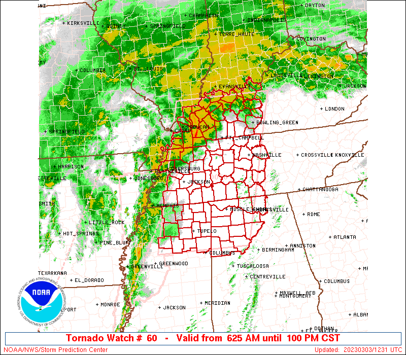
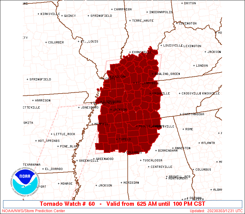
Tornado Watch Number 60
NWS Storm Prediction Center Norman OK
625 AM CST Fri Mar 3 2023
The NWS Storm Prediction Center has issued a
* Tornado Watch for portions of
Northwest Alabama
Far southeast Illinois
Western into central Kentucky
Northeast Mississippi
Western into Middle Tennessee
* Effective this Friday morning and afternoon from 625 AM until
100 PM CST.
* Primary threats include...
A few tornadoes and a couple intense tornadoes possible
Scattered damaging winds likely with isolated significant gusts
to 80 mph possible
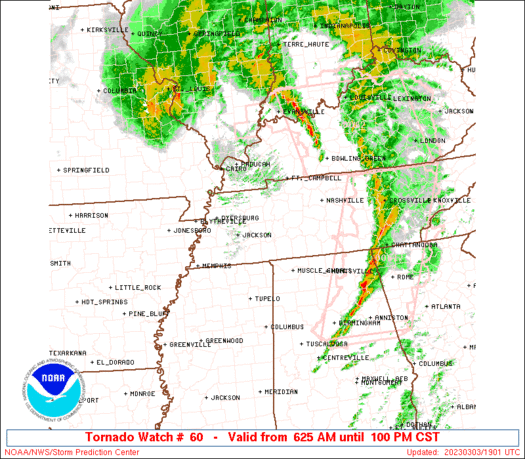
SUMMARY...A fast moving line of storms will intensify and track
northeast this morning into early afternoon. Damaging gusts and a
few tornadoes will be the primary hazards with these storms.
The tornado watch area is approximately along and 85 statute miles
east and west of a line from 10 miles west northwest of Owensboro KY
to 40 miles south southeast of Tupelo MS. For a complete depiction
of the watch see the associated watch outline update (WOUS64 KWNS
WOU0).
PRECAUTIONARY/PREPAREDNESS ACTIONS...
REMEMBER...A Tornado Watch means conditions are favorable for
tornadoes and severe thunderstorms in and close to the watch
area. Persons in these areas should be on the lookout for
threatening weather conditions and listen for later statements
and possible warnings.
&&
OTHER WATCH INFORMATION...CONTINUE...WW 59...
AVIATION...Tornadoes and a few severe thunderstorms with hail
surface and aloft to 1 inch. Extreme turbulence and surface wind
gusts to 70 knots. A few cumulonimbi with maximum tops to 400. Mean
storm motion vector 22050.
...Leitman/Edwards
 Note:
The Aviation Watch (SAW) product is an approximation to the watch area.
The actual watch is depicted by the shaded areas.
Note:
The Aviation Watch (SAW) product is an approximation to the watch area.
The actual watch is depicted by the shaded areas.
   SAW0
   WW 60 TORNADO AL IL KY MS TN 031225Z - 031900Z
   AXIS..85 STATUTE MILES EAST AND WEST OF LINE..
   10WNW OWB/OWENSBORO KY/ - 40SSE TUP/TUPELO MS/
   ..AVIATION COORDS.. 75NM E/W /22ESE PXV - 15N IGB/
   HAIL SURFACE AND ALOFT..1 INCH. WIND GUSTS..70 KNOTS.
   MAX TOPS TO 400. MEAN STORM MOTION VECTOR 22050.

   LAT...LON 37778578 33738702 33738998 37778890

   THIS IS AN APPROXIMATION TO THE WATCH AREA.  FOR A
   COMPLETE DEPICTION OF THE WATCH SEE WOUS64 KWNS
   FOR WOU0.
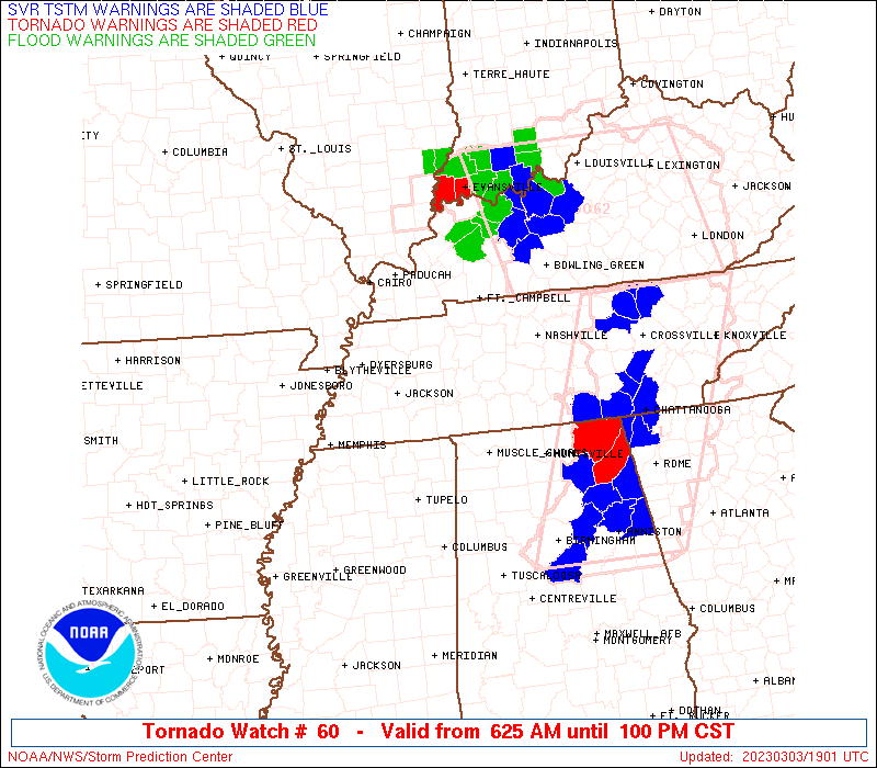
Watch 60 Status Report Messages:
STATUS REPORT #3 ON WW 60

VALID 031840Z - 031940Z

SEVERE WEATHER THREAT CONTINUES RIGHT OF A LINE FROM 25 WNW BHM
TO 30 ENE HSV TO 35 E BNA TO 25 N BNA TO 15 ENE HOP TO 35 W EVV.

FOR ADDITIONAL INFORMATION SEE MESOSCALE DISCUSSION 245

..MOORE..03/03/23

ATTN...WFO...HUN...BMX...PAH...LMK...MEG...OHX...

&&

STATUS REPORT FOR WT 60

SEVERE WEATHER THREAT CONTINUES FOR THE FOLLOWING AREAS

KYC149-177-219-031940-

KY
.    KENTUCKY COUNTIES INCLUDED ARE

MCLEAN		     MUHLENBERG 	 TODD
$$


THE WATCH STATUS MESSAGE IS FOR GUIDANCE PURPOSES ONLY.  PLEASE
REFER TO WATCH COUNTY NOTIFICATION STATEMENTS FOR OFFICIAL
INFORMATION ON COUNTIES...INDEPENDENT CITIES AND MARINE ZONES
CLEARED FROM SEVERE THUNDERSTORM AND TORNADO WATCHES.
$$

STATUS REPORT #2 ON WW 60

VALID 031805Z - 031940Z

SEVERE WEATHER THREAT CONTINUES RIGHT OF A LINE FROM 20 W TCL TO
35 NW BHM TO 10 S HSV TO 40 NNE HSV TO 40 S CKV TO 5 E MDH.

FOR ADDITIONAL INFORMATION SEE MESOSCALE DISCUSSION 245

..MOORE..03/03/23

ATTN...WFO...HUN...BMX...PAH...LMK...MEG...OHX...

&&

STATUS REPORT FOR WT 60

SEVERE WEATHER THREAT CONTINUES FOR THE FOLLOWING AREAS

ALC043-089-127-031940-

AL
.    ALABAMA COUNTIES INCLUDED ARE

CULLMAN 	     MADISON		 WALKER
$$


ILC069-151-031940-

IL
.    ILLINOIS COUNTIES INCLUDED ARE

HARDIN		     POPE
$$


KYC033-047-055-107-139-143-149-177-219-221-225-233-031940-

KY
.    KENTUCKY COUNTIES INCLUDED ARE

CALDWELL	     CHRISTIAN		 CRITTENDEN
HOPKINS 	     LIVINGSTON 	 LYON
MCLEAN		     MUHLENBERG 	 TODD
TRIGG		     UNION		 WEBSTER
$$


TNC003-149-165-189-031940-

TN
.    TENNESSEE COUNTIES INCLUDED ARE

BEDFORD 	     RUTHERFORD 	 SUMNER
WILSON
$$


THE WATCH STATUS MESSAGE IS FOR GUIDANCE PURPOSES ONLY.  PLEASE
REFER TO WATCH COUNTY NOTIFICATION STATEMENTS FOR OFFICIAL
INFORMATION ON COUNTIES...INDEPENDENT CITIES AND MARINE ZONES
CLEARED FROM SEVERE THUNDERSTORM AND TORNADO WATCHES.
$$

STATUS REPORT #1 ON WW 60

VALID 031705Z - 031840Z

SEVERE WEATHER THREAT CONTINUES RIGHT OF A LINE FROM 25 WNW TCL
TO 40 ENE CBM TO 25 SSE MSL TO 15 ENE MSL TO 35 N MSL TO 50 ESE
MKL TO 45 E MKL TO 50 NE MKL TO 40 S PAH TO 20 SSW PAH TO 15 ESE
CGI.

FOR ADDITIONAL INFORMATION SEE MESOSCALE DISCUSSION 60

..JEWELL..03/03/23

ATTN...WFO...HUN...BMX...PAH...LMK...MEG...OHX...

&&

STATUS REPORT FOR WT 60

SEVERE WEATHER THREAT CONTINUES FOR THE FOLLOWING AREAS

ALC043-057-079-083-089-103-127-133-031840-

AL
.    ALABAMA COUNTIES INCLUDED ARE

CULLMAN 	     FAYETTE		 LAWRENCE
LIMESTONE	     MADISON		 MORGAN
WALKER		     WINSTON
$$


ILC069-127-151-031840-

IL
.    ILLINOIS COUNTIES INCLUDED ARE

HARDIN		     MASSAC		 POPE
$$


KYC027-031-033-035-039-047-055-059-061-083-085-091-101-105-107-
139-141-143-145-149-157-163-177-183-213-219-221-225-227-233-
031840-

KY
.    KENTUCKY COUNTIES INCLUDED ARE

BRECKINRIDGE	     BUTLER		 CALDWELL
CALLOWAY	     CARLISLE		 CHRISTIAN
CRITTENDEN	     DAVIESS		 EDMONSON
GRAVES		     GRAYSON		 HANCOCK
HENDERSON	     HICKMAN		 HOPKINS
LIVINGSTON	     LOGAN		 LYON
MCCRACKEN	     MCLEAN		 MARSHALL
MEADE		     MUHLENBERG 	 OHIO
SIMPSON 	     TODD		 TRIGG
UNION		     WARREN		 WEBSTER
$$


TNC003-021-037-043-055-081-083-085-099-101-103-117-119-125-135-
147-149-161-165-187-189-031840-

TN
.    TENNESSEE COUNTIES INCLUDED ARE

BEDFORD 	     CHEATHAM		 DAVIDSON
DICKSON 	     GILES		 HICKMAN
HOUSTON 	     HUMPHREYS		 LAWRENCE
LEWIS		     LINCOLN		 MARSHALL
MAURY		     MONTGOMERY 	 PERRY
ROBERTSON	     RUTHERFORD 	 STEWART
SUMNER		     WILLIAMSON 	 WILSON
$$


THE WATCH STATUS MESSAGE IS FOR GUIDANCE PURPOSES ONLY.  PLEASE
REFER TO WATCH COUNTY NOTIFICATION STATEMENTS FOR OFFICIAL
INFORMATION ON COUNTIES...INDEPENDENT CITIES AND MARINE ZONES
CLEARED FROM SEVERE THUNDERSTORM AND TORNADO WATCHES.
$$
Note:
Click for Complete Product Text.
Tornadoes
Probability of 2 or more tornadoes
|
Mod (50%)
|
Probability of 1 or more strong (EF2-EF5) tornadoes
|
Mod (30%)
|
Wind
Probability of 10 or more severe wind events
|
High (70%)
|
Probability of 1 or more wind events > 65 knots
|
Mod (30%)
|
Hail
Probability of 10 or more severe hail events
|
Low (<5%)
|
Probability of 1 or more hailstones > 2 inches
|
Low (<5%)
|
Combined Severe Hail/Wind
Probability of 6 or more combined severe hail/wind events
|
High (80%)
|
For each watch, probabilities for particular events inside the watch
(listed above in each table) are determined by the issuing forecaster.
The "Low" category contains probability values ranging from less than 2%
to 20% (EF2-EF5 tornadoes), less than 5% to 20% (all other probabilities),
"Moderate" from 30% to 60%, and "High" from 70% to greater than 95%.
High values are bolded and lighter in color to provide awareness of
an increased threat for a particular event.


 @NWSSPC