|
| Mesoscale Discussion 230 |
|
< Previous MD Next MD >
|
|
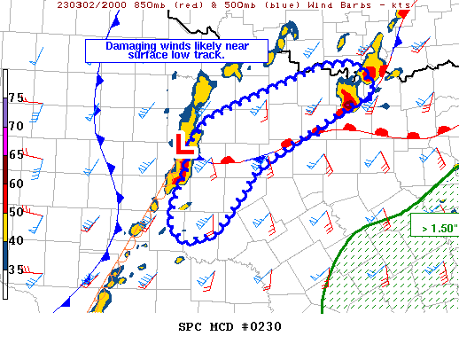
   Mesoscale Discussion 0230
   NWS Storm Prediction Center Norman OK
   0329 PM CST Thu Mar 02 2023

   Areas affected...northwest Texas

   Concerning...Severe Thunderstorm Watch 53...54...

   Valid 022129Z - 022330Z

   The severe weather threat for Severe Thunderstorm Watch 53, 54
   continues.

   SUMMARY...A corridor of damaging wind and hail appears likely with a
   storm complex tracking east/northeast with the surface low.

   DISCUSSION...Storms near the surface low are moving rapidly eastward
   centered over Shackelford County TX, with portions of the line
   transecting the stationary front extending east. Meanwhile,
   additional cells continue to form to the south of the area as higher
   theta-e air spreads north with an accelerating low-level jet.

   The area along the east-west front will remain a favorable zone for
   damaging storms, as shear, instability and lift all increase over
   the next several hours. Storm mode may remain linear which would
   favor wind, but a brief tornado may eventually occur with this
   complex downstream and as it approaches tornado watch 55. In
   addition, long hodographs and fast storm motions will favor
   wind-driven hail.

   ..Jewell/Thompson.. 03/02/2023

   ...Please see www.spc.noaa.gov for graphic product...

   ATTN...WFO...FWD...OUN...SJT...

   LAT...LON   32359882 31809924 31699968 31909992 32259984 32589966
               32969960 33279932 33929760 33969705 33609679 33409720
               33029796 32619865 32359882
|
|
Top/All Mesoscale Discussions/Forecast Products/Home
|
|


 @NWSSPC