Note:
The expiration time in the watch graphic is amended if the watch is
replaced, cancelled or extended.
Note:
Note:
The expiration time in the watch graphic is amended if the watch is
replaced, cancelled or extended.
Note: Click for
Watch Status Reports.
SEL5
URGENT - IMMEDIATE BROADCAST REQUESTED
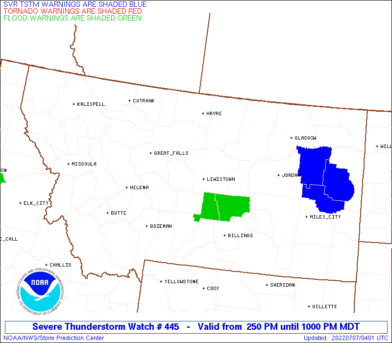
Severe Thunderstorm Watch Number 445
NWS Storm Prediction Center Norman OK
250 PM MDT Wed Jul 6 2022
The NWS Storm Prediction Center has issued a
* Severe Thunderstorm Watch for portions of
Montana
Far north-central Wyoming
* Effective this Wednesday afternoon and evening from 250 PM
until 1000 PM MDT.
* Primary threats include...
Scattered damaging winds and isolated significant gusts to 75
mph possible
Scattered large hail and isolated very large hail events to 2.5
inches in diameter possible
A tornado or two possible
SUMMARY...Several thunderstorm regimes are expected from western,
central, southern, and northeast Montana this evening. The strongest
cells may eventually consolidate into a cluster across mainly
central portions of the state.
The severe thunderstorm watch area is approximately along and 95
statute miles north and south of a line from 60 miles south
southeast of Glasgow MT to 45 miles northwest of Helena MT. For a
complete depiction of the watch see the associated watch outline
update (WOUS64 KWNS WOU5).
PRECAUTIONARY/PREPAREDNESS ACTIONS...
REMEMBER...A Severe Thunderstorm Watch means conditions are
favorable for severe thunderstorms in and close to the watch area.
Persons in these areas should be on the lookout for threatening
weather conditions and listen for later statements and possible
warnings. Severe thunderstorms can and occasionally do produce
tornadoes.
&&
OTHER WATCH INFORMATION...CONTINUE...WW 442...WW 443...WW 444...
AVIATION...A few severe thunderstorms with hail surface and aloft to
2.5 inches. Extreme turbulence and surface wind gusts to 65 knots. A
few cumulonimbi with maximum tops to 500. Mean storm motion vector
25030.
...Grams

   SEL5

   URGENT - IMMEDIATE BROADCAST REQUESTED
   Severe Thunderstorm Watch Number 445
   NWS Storm Prediction Center Norman OK
   250 PM MDT Wed Jul 6 2022

   The NWS Storm Prediction Center has issued a

   * Severe Thunderstorm Watch for portions of
     Montana
     Far north-central Wyoming

   * Effective this Wednesday afternoon and evening from 250 PM
     until 1000 PM MDT.

   * Primary threats include...
     Scattered damaging winds and isolated significant gusts to 75
       mph possible
     Scattered large hail and isolated very large hail events to 2.5
       inches in diameter possible
     A tornado or two possible

   SUMMARY...Several thunderstorm regimes are expected from western,
   central, southern, and northeast Montana this evening. The strongest
   cells may eventually consolidate into a cluster across mainly
   central portions of the state.

   The severe thunderstorm watch area is approximately along and 95
   statute miles north and south of a line from 60 miles south
   southeast of Glasgow MT to 45 miles northwest of Helena MT. For a
   complete depiction of the watch see the associated watch outline
   update (WOUS64 KWNS WOU5).

   PRECAUTIONARY/PREPAREDNESS ACTIONS...

   REMEMBER...A Severe Thunderstorm Watch means conditions are
   favorable for severe thunderstorms in and close to the watch area.
   Persons in these areas should be on the lookout for threatening
   weather conditions and listen for later statements and possible
   warnings. Severe thunderstorms can and occasionally do produce
   tornadoes.

   &&

   OTHER WATCH INFORMATION...CONTINUE...WW 442...WW 443...WW 444...

   AVIATION...A few severe thunderstorms with hail surface and aloft to
   2.5 inches. Extreme turbulence and surface wind gusts to 65 knots. A
   few cumulonimbi with maximum tops to 500. Mean storm motion vector
   25030.

   ...Grams
 Note:
The Aviation Watch (SAW) product is an approximation to the watch area.
The actual watch is depicted by the shaded areas.
Note:
The Aviation Watch (SAW) product is an approximation to the watch area.
The actual watch is depicted by the shaded areas.
   SAW5
   WW 445 SEVERE TSTM MT WY 062050Z - 070400Z
   AXIS..95 STATUTE MILES NORTH AND SOUTH OF LINE..
   60SSE GGW/GLASGOW MT/ - 45NW HLN/HELENA MT/
   ..AVIATION COORDS.. 85NM N/S /52SSE GGW - 40NW HLN/
   HAIL SURFACE AND ALOFT..2.5 INCHES. WIND GUSTS..65 KNOTS.
   MAX TOPS TO 500. MEAN STORM MOTION VECTOR 25030.

   LAT...LON 46040613 45681268 48431268 48790613

   THIS IS AN APPROXIMATION TO THE WATCH AREA.  FOR A
   COMPLETE DEPICTION OF THE WATCH SEE WOUS64 KWNS
   FOR WOU5.
Watch 445 Status Report Messages:
STATUS REPORT #5 ON WW 445

VALID 070145Z - 070230Z

SEVERE WEATHER THREAT CONTINUES RIGHT OF A LINE FROM 20 NE LVM TO
40 SSE GTF TO 60 WSW HVR TO 40 W HVR.

FOR ADDITIONAL INFORMATION SEE MESOSCALE DISCUSSION 1407

..SMITH..07/07/22

ATTN...WFO...BYZ...TFX...GGW...MSO...

&&

STATUS REPORT FOR WS 445

SEVERE WEATHER THREAT CONTINUES FOR THE FOLLOWING AREAS

MTC003-005-009-013-015-019-027-033-037-041-045-051-055-059-065-
067-069-071-083-085-087-091-095-097-103-105-107-111-070230-

MT
.    MONTANA COUNTIES INCLUDED ARE

BIG HORN	     BLAINE		 CARBON
CASCADE 	     CHOUTEAU		 DANIELS
FERGUS		     GARFIELD		 GOLDEN VALLEY
HILL		     JUDITH BASIN	 LIBERTY
MCCONE		     MEAGHER		 MUSSELSHELL
PARK		     PETROLEUM		 PHILLIPS
RICHLAND	     ROOSEVELT		 ROSEBUD
SHERIDAN	     STILLWATER 	 SWEET GRASS
TREASURE	     VALLEY		 WHEATLAND
YELLOWSTONE
$$


WYC033-070230-

WY
.    WYOMING COUNTIES INCLUDED ARE

SHERIDAN
$$


THE WATCH STATUS MESSAGE IS FOR GUIDANCE PURPOSES ONLY.  PLEASE
REFER TO WATCH COUNTY NOTIFICATION STATEMENTS FOR OFFICIAL
INFORMATION ON COUNTIES...INDEPENDENT CITIES AND MARINE ZONES
CLEARED FROM SEVERE THUNDERSTORM AND TORNADO WATCHES.
$$

STATUS REPORT #4 ON WW 445

VALID 070035Z - 070130Z

SEVERE WEATHER THREAT CONTINUES RIGHT OF A LINE FROM 5 E BZN TO
20 N HLN TO 35 ESE CTB.

FOR ADDITIONAL INFORMATION SEE MESOSCALE DISCUSSION 1406

..SMITH..07/07/22

ATTN...WFO...BYZ...TFX...GGW...MSO...

&&

STATUS REPORT FOR WS 445

SEVERE WEATHER THREAT CONTINUES FOR THE FOLLOWING AREAS

MTC003-005-007-009-013-015-019-027-033-037-041-045-051-055-059-
065-067-069-071-083-085-091-095-097-105-107-111-070130-

MT
.    MONTANA COUNTIES INCLUDED ARE

BIG HORN	     BLAINE		 BROADWATER
CARBON		     CASCADE		 CHOUTEAU
DANIELS 	     FERGUS		 GARFIELD
GOLDEN VALLEY	     HILL		 JUDITH BASIN
LIBERTY 	     MCCONE		 MEAGHER
MUSSELSHELL	     PARK		 PETROLEUM
PHILLIPS	     RICHLAND		 ROOSEVELT
SHERIDAN	     STILLWATER 	 SWEET GRASS
VALLEY		     WHEATLAND		 YELLOWSTONE
$$


WYC033-070130-

WY
.    WYOMING COUNTIES INCLUDED ARE

SHERIDAN
$$


THE WATCH STATUS MESSAGE IS FOR GUIDANCE PURPOSES ONLY.  PLEASE
REFER TO WATCH COUNTY NOTIFICATION STATEMENTS FOR OFFICIAL
INFORMATION ON COUNTIES...INDEPENDENT CITIES AND MARINE ZONES
CLEARED FROM SEVERE THUNDERSTORM AND TORNADO WATCHES.
$$

STATUS REPORT #3 ON WW 445

VALID 062335Z - 070040Z

THE SEVERE WEATHER THREAT CONTINUES ACROSS THE ENTIRE WATCH AREA.

FOR ADDITIONAL INFORMATION SEE MESOSCALE DISCUSSION 1406.

..LEITMAN..07/06/22

ATTN...WFO...BYZ...TFX...GGW...MSO...

&&

STATUS REPORT FOR WS 445

SEVERE WEATHER THREAT CONTINUES FOR THE FOLLOWING AREAS

MTC003-005-007-009-013-015-019-023-027-031-033-037-041-043-045-
049-051-055-059-065-067-069-071-073-077-083-085-091-093-095-097-
099-105-107-111-070040-

MT
.    MONTANA COUNTIES INCLUDED ARE

BIG HORN	     BLAINE		 BROADWATER
CARBON		     CASCADE		 CHOUTEAU
DANIELS 	     DEER LODGE 	 FERGUS
GALLATIN	     GARFIELD		 GOLDEN VALLEY
HILL		     JEFFERSON		 JUDITH BASIN
LEWIS AND CLARK      LIBERTY		 MCCONE
MEAGHER 	     MUSSELSHELL	 PARK
PETROLEUM	     PHILLIPS		 PONDERA
POWELL		     RICHLAND		 ROOSEVELT
SHERIDAN	     SILVER BOW 	 STILLWATER
SWEET GRASS	     TETON		 VALLEY
WHEATLAND	     YELLOWSTONE
$$


WYC033-070040-

WY
.    WYOMING COUNTIES INCLUDED ARE

SHERIDAN
$$


THE WATCH STATUS MESSAGE IS FOR GUIDANCE PURPOSES ONLY.  PLEASE
REFER TO WATCH COUNTY NOTIFICATION STATEMENTS FOR OFFICIAL
INFORMATION ON COUNTIES...INDEPENDENT CITIES AND MARINE ZONES
CLEARED FROM SEVERE THUNDERSTORM AND TORNADO WATCHES.
$$

STATUS REPORT #2 ON WW 445

VALID 062250Z - 062340Z

THE SEVERE WEATHER THREAT CONTINUES ACROSS THE ENTIRE WATCH AREA.

..LEITMAN..07/06/22

ATTN...WFO...BYZ...TFX...GGW...MSO...

&&

STATUS REPORT FOR WS 445

SEVERE WEATHER THREAT CONTINUES FOR THE FOLLOWING AREAS

MTC003-005-007-009-013-015-019-023-027-031-033-037-041-043-045-
049-051-055-059-065-067-069-071-073-077-083-085-091-093-095-097-
099-105-107-111-062340-

MT
.    MONTANA COUNTIES INCLUDED ARE

BIG HORN	     BLAINE		 BROADWATER
CARBON		     CASCADE		 CHOUTEAU
DANIELS 	     DEER LODGE 	 FERGUS
GALLATIN	     GARFIELD		 GOLDEN VALLEY
HILL		     JEFFERSON		 JUDITH BASIN
LEWIS AND CLARK      LIBERTY		 MCCONE
MEAGHER 	     MUSSELSHELL	 PARK
PETROLEUM	     PHILLIPS		 PONDERA
POWELL		     RICHLAND		 ROOSEVELT
SHERIDAN	     SILVER BOW 	 STILLWATER
SWEET GRASS	     TETON		 VALLEY
WHEATLAND	     YELLOWSTONE
$$


WYC033-062340-

WY
.    WYOMING COUNTIES INCLUDED ARE

SHERIDAN
$$


THE WATCH STATUS MESSAGE IS FOR GUIDANCE PURPOSES ONLY.  PLEASE
REFER TO WATCH COUNTY NOTIFICATION STATEMENTS FOR OFFICIAL
INFORMATION ON COUNTIES...INDEPENDENT CITIES AND MARINE ZONES
CLEARED FROM SEVERE THUNDERSTORM AND TORNADO WATCHES.
$$

STATUS REPORT #1 ON WW 445

VALID 062135Z - 062240Z

THE SEVERE WEATHER THREAT CONTINUES ACROSS THE ENTIRE WATCH AREA.

..LEITMAN..07/06/22

ATTN...WFO...BYZ...TFX...GGW...MSO...

&&

STATUS REPORT FOR WS 445

SEVERE WEATHER THREAT CONTINUES FOR THE FOLLOWING AREAS

MTC003-005-007-009-013-015-019-023-027-031-033-037-041-043-045-
049-051-055-059-065-067-069-071-073-077-083-085-091-093-095-097-
099-105-107-111-062240-

MT
.    MONTANA COUNTIES INCLUDED ARE

BIG HORN	     BLAINE		 BROADWATER
CARBON		     CASCADE		 CHOUTEAU
DANIELS 	     DEER LODGE 	 FERGUS
GALLATIN	     GARFIELD		 GOLDEN VALLEY
HILL		     JEFFERSON		 JUDITH BASIN
LEWIS AND CLARK      LIBERTY		 MCCONE
MEAGHER 	     MUSSELSHELL	 PARK
PETROLEUM	     PHILLIPS		 PONDERA
POWELL		     RICHLAND		 ROOSEVELT
SHERIDAN	     SILVER BOW 	 STILLWATER
SWEET GRASS	     TETON		 VALLEY
WHEATLAND	     YELLOWSTONE
$$


WYC033-062240-

WY
.    WYOMING COUNTIES INCLUDED ARE

SHERIDAN
$$


THE WATCH STATUS MESSAGE IS FOR GUIDANCE PURPOSES ONLY.  PLEASE
REFER TO WATCH COUNTY NOTIFICATION STATEMENTS FOR OFFICIAL
INFORMATION ON COUNTIES...INDEPENDENT CITIES AND MARINE ZONES
CLEARED FROM SEVERE THUNDERSTORM AND TORNADO WATCHES.
$$
Note:
Click for Complete Product Text.
Tornadoes
Probability of 2 or more tornadoes
|
Low (20%)
|
Probability of 1 or more strong (EF2-EF5) tornadoes
|
Low (5%)
|
Wind
Probability of 10 or more severe wind events
|
Mod (50%)
|
Probability of 1 or more wind events > 65 knots
|
Mod (50%)
|
Hail
Probability of 10 or more severe hail events
|
Mod (40%)
|
Probability of 1 or more hailstones > 2 inches
|
Mod (40%)
|
Combined Severe Hail/Wind
Probability of 6 or more combined severe hail/wind events
|
High (80%)
|
For each watch, probabilities for particular events inside the watch
(listed above in each table) are determined by the issuing forecaster.
The "Low" category contains probability values ranging from less than 2%
to 20% (EF2-EF5 tornadoes), less than 5% to 20% (all other probabilities),
"Moderate" from 30% to 60%, and "High" from 70% to greater than 95%.
High values are bolded and lighter in color to provide awareness of
an increased threat for a particular event.


 @NWSSPC