 Note:
The expiration time in the watch graphic is amended if the watch is
replaced, cancelled or extended.
Note:
Note:
The expiration time in the watch graphic is amended if the watch is
replaced, cancelled or extended.
Note: Click for
Watch Status Reports.
SEL6
URGENT - IMMEDIATE BROADCAST REQUESTED
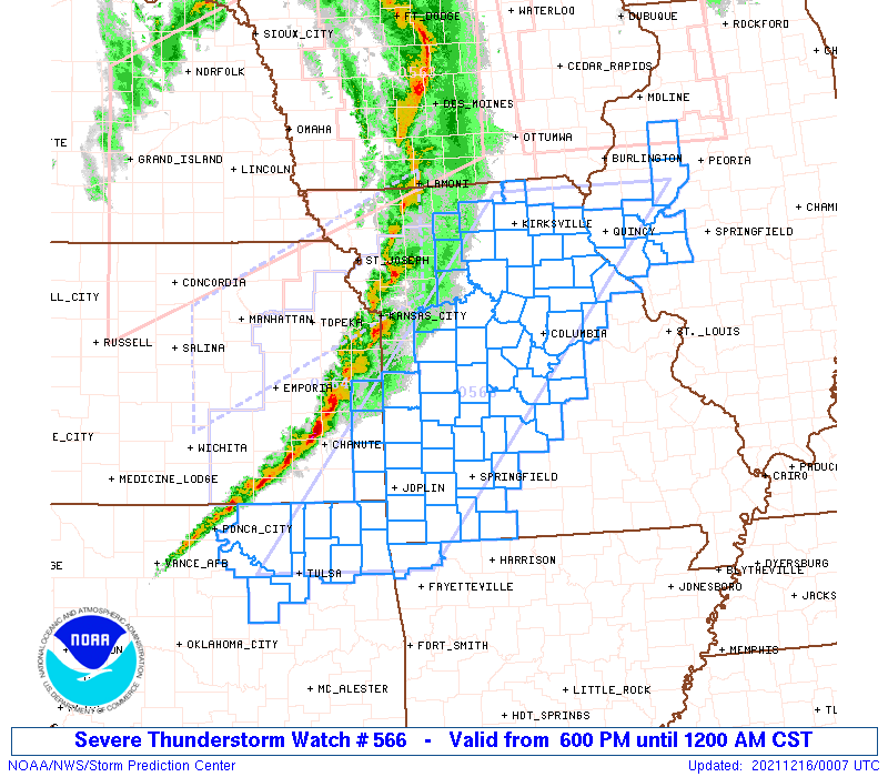
Severe Thunderstorm Watch Number 566
NWS Storm Prediction Center Norman OK
600 PM CST Wed Dec 15 2021
The NWS Storm Prediction Center has issued a
* Severe Thunderstorm Watch for portions of
Northwest Arkansas
West Central Illinois
Southeast Kansas
Central and Southwest Missouri
Northeast Oklahoma
* Effective this Wednesday night from 600 PM until Midnight CST.
* Primary threats include...
Scattered damaging winds likely with isolated significant gusts
to 75 mph possible
Isolated large hail events to 1 inch in diameter possible
A tornado or two possible
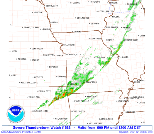
SUMMARY...A line of thunderstorms over eastern Kansas will track
eastward across the watch area this evening. The strongest cores
along the line will pose a risk of locally damaging wind gusts.
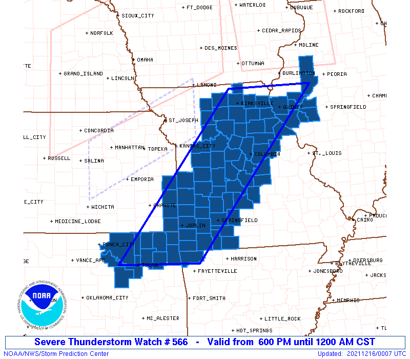
The severe thunderstorm watch area is approximately along and 70
statute miles east and west of a line from 40 miles north northwest
of Quincy IL to 40 miles southwest of Grove OK. For a complete
depiction of the watch see the associated watch outline update
(WOUS64 KWNS WOU6).
PRECAUTIONARY/PREPAREDNESS ACTIONS...
REMEMBER...A Severe Thunderstorm Watch means conditions are
favorable for severe thunderstorms in and close to the watch area.
Persons in these areas should be on the lookout for threatening
weather conditions and listen for later statements and possible
warnings. Severe thunderstorms can and occasionally do produce
tornadoes.
&&
OTHER WATCH INFORMATION...CONTINUE...WW 563...WW 564...WW 565...
AVIATION...A few severe thunderstorms with hail surface and aloft to
1 inch. Extreme turbulence and surface wind gusts to 65 knots. A few
cumulonimbi with maximum tops to 500. Mean storm motion vector
24040.
...Hart
 Note:
The Aviation Watch (SAW) product is an approximation to the watch area.
The actual watch is depicted by the shaded areas.
Note:
The Aviation Watch (SAW) product is an approximation to the watch area.
The actual watch is depicted by the shaded areas.
   SAW6
   WW 566 SEVERE TSTM AR IL KS MO OK 160000Z - 160600Z
   AXIS..70 STATUTE MILES EAST AND WEST OF LINE..
   40NNW UIN/QUINCY IL/ - 40SW GMJ/GROVE OK/
   ..AVIATION COORDS.. 60NM E/W /39NNW UIN - 26E TUL/
   HAIL SURFACE AND ALOFT..1 INCH. WIND GUSTS..65 KNOTS.
   MAX TOPS TO 500. MEAN STORM MOTION VECTOR 24040.

   LAT...LON 40489016 36189399 36189650 40489282

   THIS IS AN APPROXIMATION TO THE WATCH AREA.  FOR A
   COMPLETE DEPICTION OF THE WATCH SEE WOUS64 KWNS
   FOR WOU6.
Watch 566 Status Report Messages:
STATUS REPORT #2 ON WW 566

VALID 160355Z - 160440Z

SEVERE WEATHER THREAT CONTINUES RIGHT OF A LINE FROM 15 WSW BVO
TO 30 WNW SGF TO 30 SW JEF TO 10 SSW UIN TO 15 SE BRL.

FOR ADDITIONAL INFORMATION SEE MESOSCALE DISCUSSION 2039

..SQUITIERI..12/16/21

ATTN...WFO...TSA...LSX...ILX...SGF...EAX...

&&

STATUS REPORT FOR WS 566

SEVERE WEATHER THREAT CONTINUES FOR THE FOLLOWING AREAS

ARC007-160440-

AR
.    ARKANSAS COUNTIES INCLUDED ARE

BENTON
$$


ILC001-009-017-057-095-137-149-169-171-160440-

IL
.    ILLINOIS COUNTIES INCLUDED ARE

ADAMS		     BROWN		 CASS
FULTON		     KNOX		 MORGAN
PIKE		     SCHUYLER		 SCOTT
$$


KSC021-160440-

KS
.    KANSAS COUNTIES INCLUDED ARE

CHEROKEE
$$


MOC009-027-029-043-057-059-077-097-105-109-119-125-131-139-145-
151-163-167-169-173-209-213-225-160440-

MO
.    MISSOURI COUNTIES INCLUDED ARE

BARRY		     CALLAWAY		 CAMDEN
CHRISTIAN	     DADE		 DALLAS
GREENE		     JASPER		 LACLEDE
LAWRENCE	     MCDONALD		 MARIES
MILLER		     MONTGOMERY 	 NEWTON
OSAGE		     PIKE		 POLK
PULASKI 	     RALLS		 STONE
TANEY		     WEBSTER
$$


OKC035-037-041-097-105-115-131-143-147-160440-

OK
.    OKLAHOMA COUNTIES INCLUDED ARE

CRAIG		     CREEK		 DELAWARE
MAYES		     NOWATA		 OTTAWA
ROGERS		     TULSA		 WASHINGTON
$$


THE WATCH STATUS MESSAGE IS FOR GUIDANCE PURPOSES ONLY.  PLEASE
REFER TO WATCH COUNTY NOTIFICATION STATEMENTS FOR OFFICIAL
INFORMATION ON COUNTIES...INDEPENDENT CITIES AND MARINE ZONES
CLEARED FROM SEVERE THUNDERSTORM AND TORNADO WATCHES.
$$

STATUS REPORT #1 ON WW 566

VALID 160250Z - 160340Z

SEVERE WEATHER THREAT CONTINUES RIGHT OF A LINE FROM 20 NNE BVO
TO 35 SE SZL TO 30 WSW BRL.

..SQUITIERI..12/16/21

ATTN...WFO...TSA...LSX...ILX...SGF...EAX...

&&

STATUS REPORT FOR WS 566

SEVERE WEATHER THREAT CONTINUES FOR THE FOLLOWING AREAS

ARC007-160340-

AR
.    ARKANSAS COUNTIES INCLUDED ARE

BENTON
$$


ILC001-009-017-057-095-137-149-169-171-160340-

IL
.    ILLINOIS COUNTIES INCLUDED ARE

ADAMS		     BROWN		 CASS
FULTON		     KNOX		 MORGAN
PIKE		     SCHUYLER		 SCOTT
$$


KSC021-160340-

KS
.    KANSAS COUNTIES INCLUDED ARE

CHEROKEE
$$


MOC007-009-011-019-027-029-039-043-051-057-059-077-085-097-105-
109-111-119-125-127-131-135-137-139-141-145-151-163-167-169-173-
185-205-209-213-225-160340-

MO
.    MISSOURI COUNTIES INCLUDED ARE

AUDRAIN 	     BARRY		 BARTON
BOONE		     CALLAWAY		 CAMDEN
CEDAR		     CHRISTIAN		 COLE
DADE		     DALLAS		 GREENE
HICKORY 	     JASPER		 LACLEDE
LAWRENCE	     LEWIS		 MCDONALD
MARIES		     MARION		 MILLER
MONITEAU	     MONROE		 MONTGOMERY
MORGAN		     NEWTON		 OSAGE
PIKE		     POLK		 PULASKI
RALLS		     ST. CLAIR		 SHELBY
STONE		     TANEY		 WEBSTER
$$


OKC035-037-041-097-105-113-115-117-131-143-147-160340-

OK
.    OKLAHOMA COUNTIES INCLUDED ARE

CRAIG		     CREEK		 DELAWARE
MAYES		     NOWATA		 OSAGE
OTTAWA		     PAWNEE		 ROGERS
TULSA		     WASHINGTON
$$


THE WATCH STATUS MESSAGE IS FOR GUIDANCE PURPOSES ONLY.  PLEASE
REFER TO WATCH COUNTY NOTIFICATION STATEMENTS FOR OFFICIAL
INFORMATION ON COUNTIES...INDEPENDENT CITIES AND MARINE ZONES
CLEARED FROM SEVERE THUNDERSTORM AND TORNADO WATCHES.
$$
Note:
Click for Complete Product Text.
Tornadoes
Probability of 2 or more tornadoes
|
Low (20%)
|
Probability of 1 or more strong (EF2-EF5) tornadoes
|
Low (<2%)
|
Wind
Probability of 10 or more severe wind events
|
High (70%)
|
Probability of 1 or more wind events > 65 knots
|
Mod (30%)
|
Hail
Probability of 10 or more severe hail events
|
Low (20%)
|
Probability of 1 or more hailstones > 2 inches
|
Low (<5%)
|
Combined Severe Hail/Wind
Probability of 6 or more combined severe hail/wind events
|
High (90%)
|
For each watch, probabilities for particular events inside the watch
(listed above in each table) are determined by the issuing forecaster.
The "Low" category contains probability values ranging from less than 2%
to 20% (EF2-EF5 tornadoes), less than 5% to 20% (all other probabilities),
"Moderate" from 30% to 60%, and "High" from 70% to greater than 95%.
High values are bolded and lighter in color to provide awareness of
an increased threat for a particular event.


 @NWSSPC