 Note:
The expiration time in the watch graphic is amended if the watch is
replaced, cancelled or extended.
Note:
Note:
The expiration time in the watch graphic is amended if the watch is
replaced, cancelled or extended.
Note: Click for
Watch Status Reports.
SEL7
URGENT - IMMEDIATE BROADCAST REQUESTED
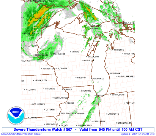
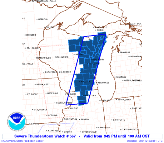
Severe Thunderstorm Watch Number 567
NWS Storm Prediction Center Norman OK
945 PM CST Wed Dec 15 2021
The NWS Storm Prediction Center has issued a
* Severe Thunderstorm Watch for portions of
Northern Illinois
Southern Upper Michigan
Eastern Wisconsin
Lake Michigan
* Effective this Wednesday night and Thursday morning from 945 PM
until 100 AM CST.
* Primary threats include...
Scattered damaging winds likely with isolated significant gusts
to 80 mph possible
A tornado or two possible
SUMMARY...A fast-moving line of thunderstorms will spread across the
watch area during the next few hours. This line has resulted in
numerous reports of wind damage during the past few hours, and will
likely remain capable of at least occasional severe wind gusts until
after midnight.
The severe thunderstorm watch area is approximately along and 50
statute miles east and west of a line from 30 miles northwest of
Escanaba MI to 50 miles southwest of Rockford IL. For a complete
depiction of the watch see the associated watch outline update
(WOUS64 KWNS WOU7).
PRECAUTIONARY/PREPAREDNESS ACTIONS...
REMEMBER...A Severe Thunderstorm Watch means conditions are
favorable for severe thunderstorms in and close to the watch area.
Persons in these areas should be on the lookout for threatening
weather conditions and listen for later statements and possible
warnings. Severe thunderstorms can and occasionally do produce
tornadoes.
&&
OTHER WATCH INFORMATION...CONTINUE...WW 565...WW 566...
AVIATION...A few severe thunderstorms with hail surface and aloft to
0.5 inches. Extreme turbulence and surface wind gusts to 70 knots. A
few cumulonimbi with maximum tops to 450. Mean storm motion vector
24055.
...Hart
   SEL7

   URGENT - IMMEDIATE BROADCAST REQUESTED
   Severe Thunderstorm Watch Number 567
   NWS Storm Prediction Center Norman OK
   945 PM CST Wed Dec 15 2021

   The NWS Storm Prediction Center has issued a

   * Severe Thunderstorm Watch for portions of
     Northern Illinois
     Southern Upper Michigan
     Eastern Wisconsin
     Lake Michigan

   * Effective this Wednesday night and Thursday morning from 945 PM
     until 100 AM CST.

   * Primary threats include...
     Scattered damaging winds likely with isolated significant gusts
       to 80 mph possible
     A tornado or two possible

   SUMMARY...A fast-moving line of thunderstorms will spread across the
   watch area during the next few hours.  This line has resulted in
   numerous reports of wind damage during the past few hours, and will
   likely remain capable of at least occasional severe wind gusts until
   after midnight.

   The severe thunderstorm watch area is approximately along and 50
   statute miles east and west of a line from 30 miles northwest of
   Escanaba MI to 50 miles southwest of Rockford IL. For a complete
   depiction of the watch see the associated watch outline update
   (WOUS64 KWNS WOU7).

   PRECAUTIONARY/PREPAREDNESS ACTIONS...

   REMEMBER...A Severe Thunderstorm Watch means conditions are
   favorable for severe thunderstorms in and close to the watch area.
   Persons in these areas should be on the lookout for threatening
   weather conditions and listen for later statements and possible
   warnings. Severe thunderstorms can and occasionally do produce
   tornadoes.

   &&

   OTHER WATCH INFORMATION...CONTINUE...WW 565...WW 566...

   AVIATION...A few severe thunderstorms with hail surface and aloft to
   0.5 inches. Extreme turbulence and surface wind gusts to 70 knots. A
   few cumulonimbi with maximum tops to 450. Mean storm motion vector
   24055.

   ...Hart
 Note:
The Aviation Watch (SAW) product is an approximation to the watch area.
The actual watch is depicted by the shaded areas.
Note:
The Aviation Watch (SAW) product is an approximation to the watch area.
The actual watch is depicted by the shaded areas.
   SAW7
   WW 567 SEVERE TSTM IL MI WI LM 160345Z - 160700Z
   AXIS..50 STATUTE MILES EAST AND WEST OF LINE..
   30NW ESC/ESCANABA MI/ - 50SW RFD/ROCKFORD IL/
   ..AVIATION COORDS.. 45NM E/W /21SSW SAW - 33NNW BDF/
   HAIL SURFACE AND ALOFT..0.5 INCH. WIND GUSTS..70 KNOTS.
   MAX TOPS TO 450. MEAN STORM MOTION VECTOR 24055.

   LAT...LON 46028650 41688882 41689075 46028858

   THIS IS AN APPROXIMATION TO THE WATCH AREA.  FOR A
   COMPLETE DEPICTION OF THE WATCH SEE WOUS64 KWNS
   FOR WOU7.
Watch 567 Status Report Message has not been issued yet.
Note:
Click for Complete Product Text.
Tornadoes
Probability of 2 or more tornadoes
|
Low (20%)
|
Probability of 1 or more strong (EF2-EF5) tornadoes
|
Low (<2%)
|
Wind
Probability of 10 or more severe wind events
|
High (70%)
|
Probability of 1 or more wind events > 65 knots
|
Mod (30%)
|
Hail
Probability of 10 or more severe hail events
|
Low (<5%)
|
Probability of 1 or more hailstones > 2 inches
|
Low (<5%)
|
Combined Severe Hail/Wind
Probability of 6 or more combined severe hail/wind events
|
High (80%)
|
For each watch, probabilities for particular events inside the watch
(listed above in each table) are determined by the issuing forecaster.
The "Low" category contains probability values ranging from less than 2%
to 20% (EF2-EF5 tornadoes), less than 5% to 20% (all other probabilities),
"Moderate" from 30% to 60%, and "High" from 70% to greater than 95%.
High values are bolded and lighter in color to provide awareness of
an increased threat for a particular event.


 @NWSSPC


