Note:
The expiration time in the watch graphic is amended if the watch is
replaced, cancelled or extended.
Note:
Note:
The expiration time in the watch graphic is amended if the watch is
replaced, cancelled or extended.
Note: Click for
Watch Status Reports.
SEL4
URGENT - IMMEDIATE BROADCAST REQUESTED
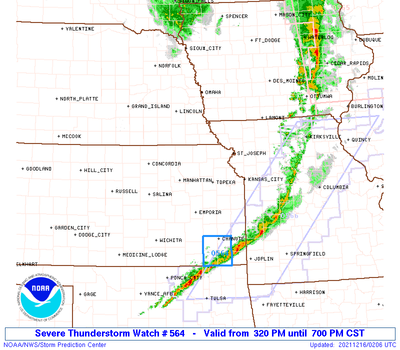
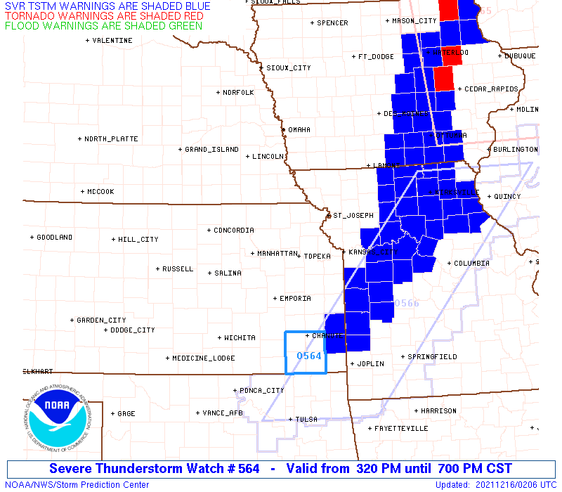
Severe Thunderstorm Watch Number 564
NWS Storm Prediction Center Norman OK
320 PM CST Wed Dec 15 2021
The NWS Storm Prediction Center has issued a
* Severe Thunderstorm Watch for portions of
Eastern Kansas
West central and northwest Missouri
* Effective this Wednesday afternoon and evening from 320 PM
until 700 PM CST.
* Primary threats include...
Scattered damaging wind gusts to 70 mph possible
SUMMARY...A narrow squall line will continue to spread eastward
through the afternoon and early evening, with the potential for
occasional damaging gusts of 60-70 mph.
The severe thunderstorm watch area is approximately along and 50
statute miles north and south of a line from 55 miles southwest of
Manhattan KS to 55 miles east northeast of Saint Joseph MO. For a
complete depiction of the watch see the associated watch outline
update (WOUS64 KWNS WOU4).
PRECAUTIONARY/PREPAREDNESS ACTIONS...
REMEMBER...A Severe Thunderstorm Watch means conditions are
favorable for severe thunderstorms in and close to the watch area.
Persons in these areas should be on the lookout for threatening
weather conditions and listen for later statements and possible
warnings. Severe thunderstorms can and occasionally do produce
tornadoes.
&&
OTHER WATCH INFORMATION...CONTINUE...WW 563...
AVIATION...A few severe thunderstorms with hail surface and aloft to
0.5 inches. Extreme turbulence and surface wind gusts to 60 knots. A
few cumulonimbi with maximum tops to 450. Mean storm motion vector
24050.
...Thompson

   SEL4

   URGENT - IMMEDIATE BROADCAST REQUESTED
   Severe Thunderstorm Watch Number 564
   NWS Storm Prediction Center Norman OK
   320 PM CST Wed Dec 15 2021

   The NWS Storm Prediction Center has issued a

   * Severe Thunderstorm Watch for portions of
     Eastern Kansas
     West central  and northwest Missouri

   * Effective this Wednesday afternoon and evening from 320 PM
     until 700 PM CST.

   * Primary threats include...
     Scattered damaging wind gusts to 70 mph possible

   SUMMARY...A narrow squall line will continue to spread eastward
   through the afternoon and early evening, with the potential for
   occasional damaging gusts of 60-70 mph.

   The severe thunderstorm watch area is approximately along and 50
   statute miles north and south of a line from 55 miles southwest of
   Manhattan KS to 55 miles east northeast of Saint Joseph MO. For a
   complete depiction of the watch see the associated watch outline
   update (WOUS64 KWNS WOU4).

   PRECAUTIONARY/PREPAREDNESS ACTIONS...

   REMEMBER...A Severe Thunderstorm Watch means conditions are
   favorable for severe thunderstorms in and close to the watch area.
   Persons in these areas should be on the lookout for threatening
   weather conditions and listen for later statements and possible
   warnings. Severe thunderstorms can and occasionally do produce
   tornadoes.

   &&

   OTHER WATCH INFORMATION...CONTINUE...WW 563...

   AVIATION...A few severe thunderstorms with hail surface and aloft to
   0.5 inches. Extreme turbulence and surface wind gusts to 60 knots. A
   few cumulonimbi with maximum tops to 450. Mean storm motion vector
   24050.

   ...Thompson
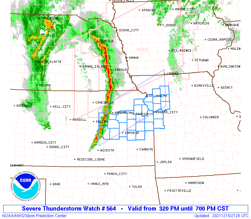
 Note:
The Aviation Watch (SAW) product is an approximation to the watch area.
The actual watch is depicted by the shaded areas.
Note:
The Aviation Watch (SAW) product is an approximation to the watch area.
The actual watch is depicted by the shaded areas.
   SAW4
   WW 564 SEVERE TSTM KS MO 152120Z - 160100Z
   AXIS..50 STATUTE MILES NORTH AND SOUTH OF LINE..
   55SW MHK/MANHATTAN KS/ - 55ENE STJ/SAINT JOSEPH MO/
   ..AVIATION COORDS.. 45NM N/S /24SSE SLN - 59NE MCI/
   HAIL SURFACE AND ALOFT..0.5 INCH. WIND GUSTS..60 KNOTS.
   MAX TOPS TO 450. MEAN STORM MOTION VECTOR 24050.

   LAT...LON 39299739 40799396 39349396 37849739

   THIS IS AN APPROXIMATION TO THE WATCH AREA.  FOR A
   COMPLETE DEPICTION OF THE WATCH SEE WOUS64 KWNS
   FOR WOU4.
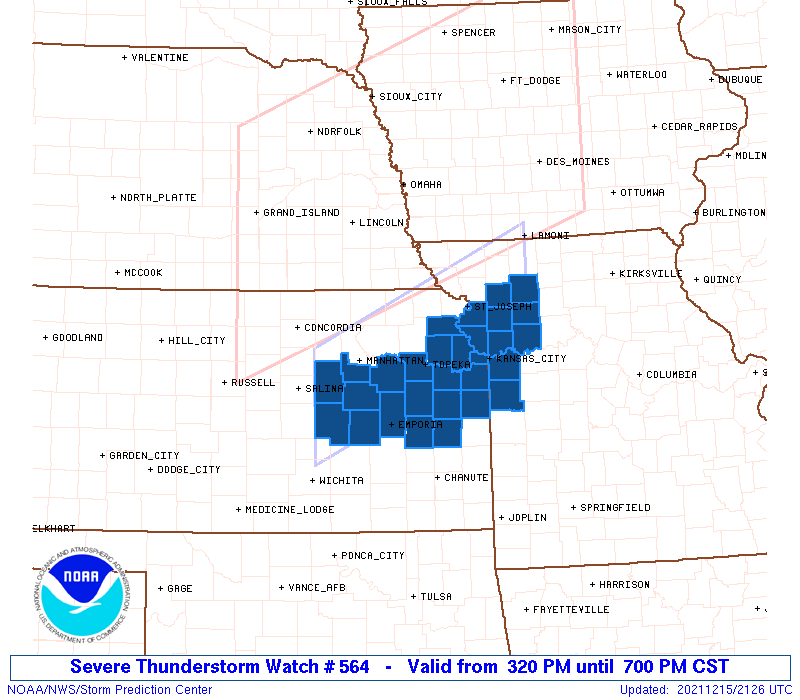
Watch 564 Status Report Messages:
STATUS REPORT #2 ON WW 564
VALID 160020Z - 160100Z
SEVERE WEATHER THREAT CONTINUES RIGHT OF A LINE FROM 5 NNE OJC TO
40 SW LWD TO 25 NNE LWD.
WW 564 WILL BE ALLOWED TO EXPIRE AT 160100Z.
..SQUITIERI..12/16/21
ATTN...WFO...TOP...EAX...ICT...
&&
STATUS REPORT FOR WS 564
SEVERE WEATHER THREAT CONTINUES FOR THE FOLLOWING AREAS
KSC001-003-019-035-049-099-121-125-133-205-207-209-160100-
KS
. KANSAS COUNTIES INCLUDED ARE
ALLEN ANDERSON CHAUTAUQUA
COWLEY ELK LABETTE
MIAMI MONTGOMERY NEOSHO
WILSON WOODSON WYANDOTTE
$$
MOC025-037-047-049-061-063-095-177-160100-
MO
. MISSOURI COUNTIES INCLUDED ARE
CALDWELL CASS CLAY
CLINTON DAVIESS DEKALB
JACKSON RAY
$$
THE WATCH STATUS MESSAGE IS FOR GUIDANCE PURPOSES ONLY. PLEASE
REFER TO WATCH COUNTY NOTIFICATION STATEMENTS FOR OFFICIAL
INFORMATION ON COUNTIES...INDEPENDENT CITIES AND MARINE ZONES
CLEARED FROM SEVERE THUNDERSTORM AND TORNADO WATCHES.
$$
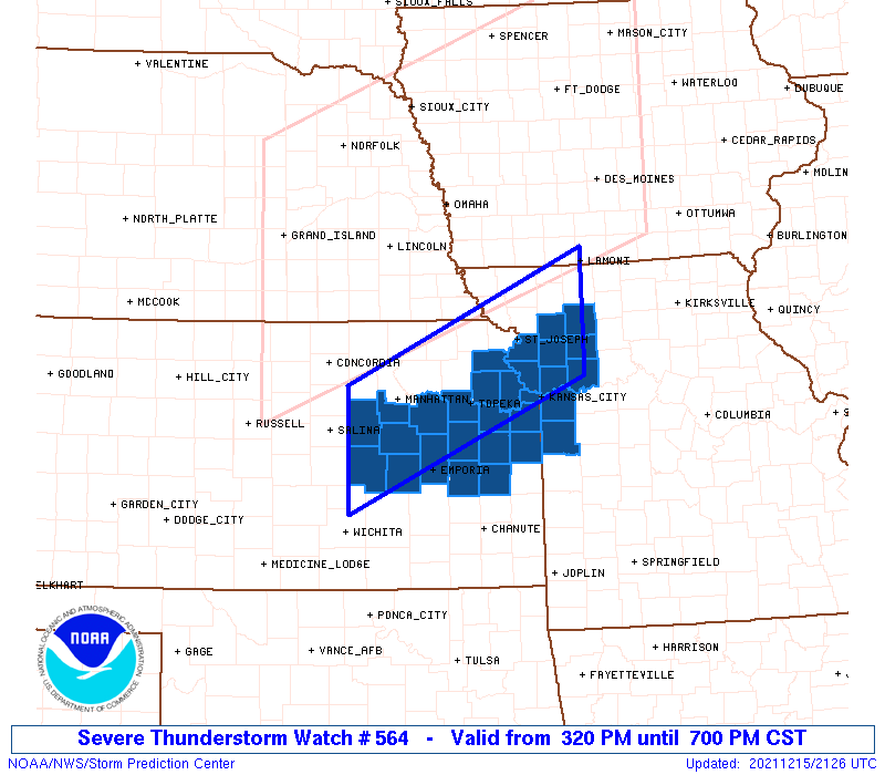
STATUS REPORT #1 ON WW 564
VALID 152345Z - 160040Z
SEVERE WEATHER THREAT CONTINUES RIGHT OF A LINE FROM 35 ENE EMP
TO 35 W LWD.
FOR ADDITIONAL INFORMATION SEE MESOSCALE DISCUSSION 2033
..SQUITIERI..12/15/21
ATTN...WFO...TOP...EAX...ICT...
&&
STATUS REPORT FOR WS 564
SEVERE WEATHER THREAT CONTINUES FOR THE FOLLOWING AREAS
KSC001-003-019-031-035-045-049-059-073-091-099-103-121-125-133-
139-205-207-209-160040-
KS
. KANSAS COUNTIES INCLUDED ARE
ALLEN ANDERSON CHAUTAUQUA
COFFEY COWLEY DOUGLAS
ELK FRANKLIN GREENWOOD
JOHNSON LABETTE LEAVENWORTH
MIAMI MONTGOMERY NEOSHO
OSAGE WILSON WOODSON
WYANDOTTE
$$
MOC021-025-037-047-049-061-063-095-165-177-160040-
MO
. MISSOURI COUNTIES INCLUDED ARE
BUCHANAN CALDWELL CASS
CLAY CLINTON DAVIESS
DEKALB JACKSON PLATTE
RAY
$$
THE WATCH STATUS MESSAGE IS FOR GUIDANCE PURPOSES ONLY. PLEASE
REFER TO WATCH COUNTY NOTIFICATION STATEMENTS FOR OFFICIAL
INFORMATION ON COUNTIES...INDEPENDENT CITIES AND MARINE ZONES
CLEARED FROM SEVERE THUNDERSTORM AND TORNADO WATCHES.
$$
Note:
Click for Complete Product Text.
Tornadoes
Probability of 2 or more tornadoes
|
Low (10%)
|
Probability of 1 or more strong (EF2-EF5) tornadoes
|
Low (5%)
|
Wind
Probability of 10 or more severe wind events
|
Mod (50%)
|
Probability of 1 or more wind events > 65 knots
|
Low (10%)
|
Hail
Probability of 10 or more severe hail events
|
Low (<5%)
|
Probability of 1 or more hailstones > 2 inches
|
Low (<5%)
|
Combined Severe Hail/Wind
Probability of 6 or more combined severe hail/wind events
|
Mod (60%)
|
For each watch, probabilities for particular events inside the watch
(listed above in each table) are determined by the issuing forecaster.
The "Low" category contains probability values ranging from less than 2%
to 20% (EF2-EF5 tornadoes), less than 5% to 20% (all other probabilities),
"Moderate" from 30% to 60%, and "High" from 70% to greater than 95%.
High values are bolded and lighter in color to provide awareness of
an increased threat for a particular event.


 @NWSSPC