 Note:
The expiration time in the watch graphic is amended if the watch is
replaced, cancelled or extended.
Note:
Note:
The expiration time in the watch graphic is amended if the watch is
replaced, cancelled or extended.
Note: Click for
Watch Status Reports.
SEL0
URGENT - IMMEDIATE BROADCAST REQUESTED
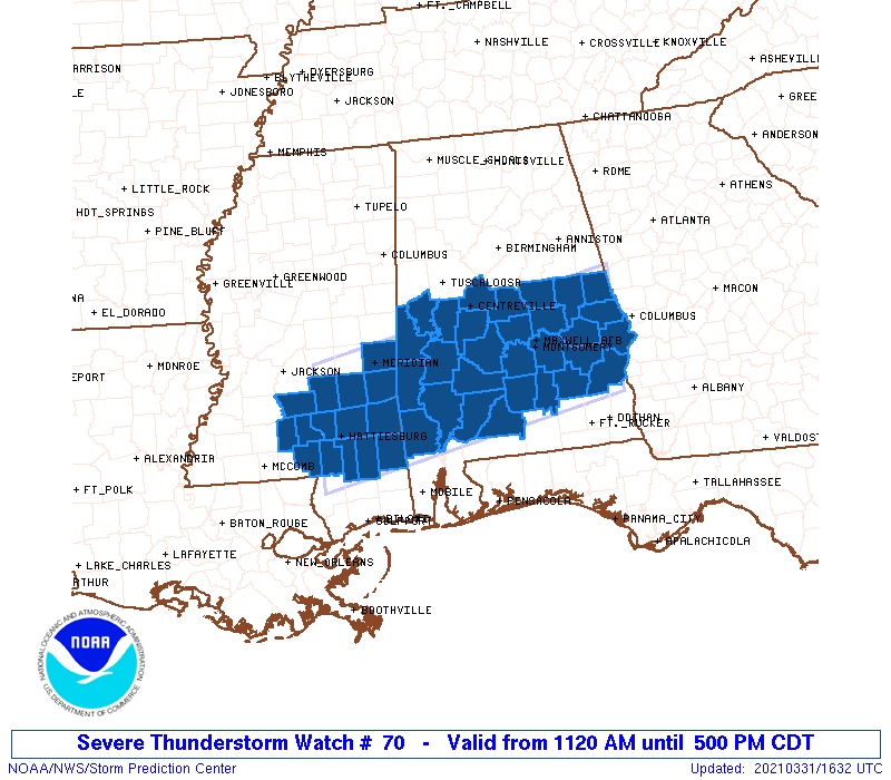
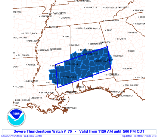
Severe Thunderstorm Watch Number 70
NWS Storm Prediction Center Norman OK
1120 AM CDT Wed Mar 31 2021
The NWS Storm Prediction Center has issued a
* Severe Thunderstorm Watch for portions of
Central and southern Alabama
Southeast Mississippi
* Effective this Wednesday morning and afternoon from 1120 AM
until 500 PM CDT.
* Primary threats include...
Scattered damaging wind gusts to 70 mph likely
Isolated large hail events to 1.5 inches in diameter possible
A tornado or two possible
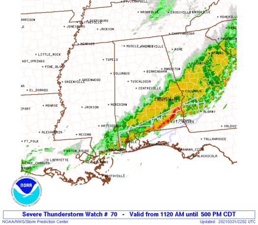
SUMMARY...Thunderstorm clusters along a southeast-moving cold front
will be capable of producing scattered damaging winds and a brief
tornado through this afternoon.
The severe thunderstorm watch area is approximately along and 55
statute miles north and south of a line from 20 miles southeast of
Auburn AL to 20 miles west northwest of Pine Belt MS. For a complete
depiction of the watch see the associated watch outline update
(WOUS64 KWNS WOU0).
PRECAUTIONARY/PREPAREDNESS ACTIONS...
REMEMBER...A Severe Thunderstorm Watch means conditions are
favorable for severe thunderstorms in and close to the watch area.
Persons in these areas should be on the lookout for threatening
weather conditions and listen for later statements and possible
warnings. Severe thunderstorms can and occasionally do produce
tornadoes.
&&
AVIATION...A few severe thunderstorms with hail surface and aloft to
1.5 inches. Extreme turbulence and surface wind gusts to 60 knots. A
few cumulonimbi with maximum tops to 500. Mean storm motion vector
25035.
...Grams
 Note:
The Aviation Watch (SAW) product is an approximation to the watch area.
The actual watch is depicted by the shaded areas.
Note:
The Aviation Watch (SAW) product is an approximation to the watch area.
The actual watch is depicted by the shaded areas.
   SAW0
   WW 70 SEVERE TSTM AL MS 311620Z - 312200Z
   AXIS..55 STATUTE MILES NORTH AND SOUTH OF LINE..
   20SE AUO/AUBURN AL/ - 20WNW PIB/PINE BELT MS/
   ..AVIATION COORDS.. 50NM N/S /39S LGC - 36ENE MCB/
   HAIL SURFACE AND ALOFT..1.5 INCHES. WIND GUSTS..60 KNOTS.
   MAX TOPS TO 500. MEAN STORM MOTION VECTOR 25035.

   LAT...LON 31618519 30788964 32388964 33208519

   THIS IS AN APPROXIMATION TO THE WATCH AREA.  FOR A
   COMPLETE DEPICTION OF THE WATCH SEE WOUS64 KWNS
   FOR WOU0.
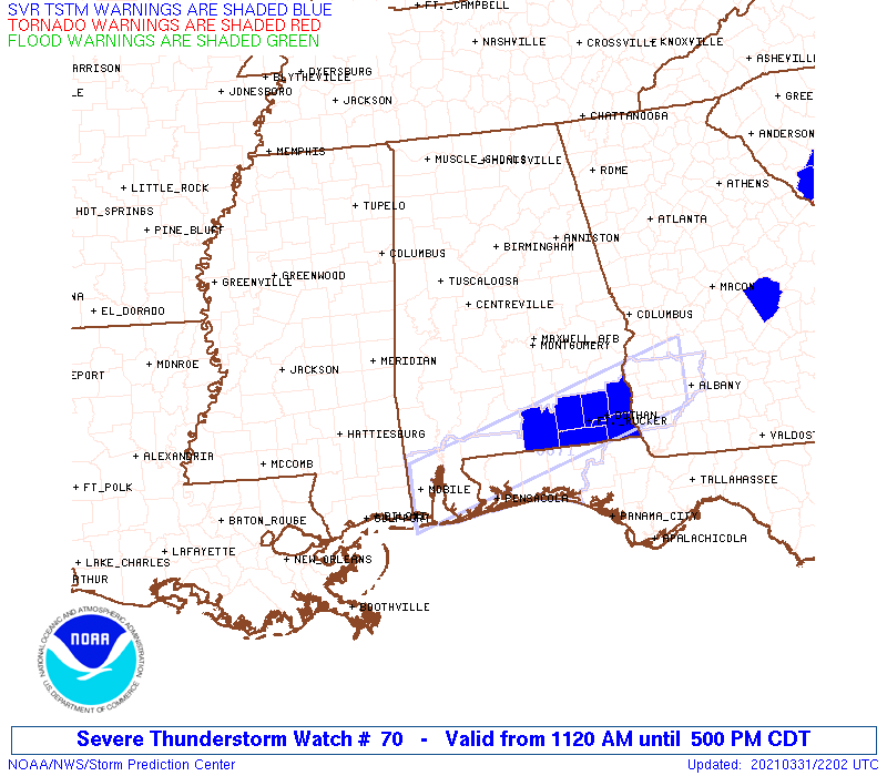
Watch 70 Status Report Messages:
STATUS REPORT #5 ON WW 70

VALID 312135Z - 312240Z

SEVERE WEATHER THREAT CONTINUES RIGHT OF A LINE FROM 25 NE ASD TO
10 WSW GZH TO 25 W TOI TO 20 N TOI TO 30 SSE CSG.

FOR ADDITIONAL INFORMATION SEE MESOSCALE DISCUSSION 311

..MOORE..03/31/21

ATTN...WFO...BMX...MOB...JAN...

&&

STATUS REPORT FOR WS 70

SEVERE WEATHER THREAT CONTINUES FOR THE FOLLOWING AREAS

ALC005-041-109-312240-

AL
.    ALABAMA COUNTIES INCLUDED ARE

BARBOUR 	     CRENSHAW		 PIKE
$$


THE WATCH STATUS MESSAGE IS FOR GUIDANCE PURPOSES ONLY.  PLEASE
REFER TO WATCH COUNTY NOTIFICATION STATEMENTS FOR OFFICIAL
INFORMATION ON COUNTIES...INDEPENDENT CITIES AND MARINE ZONES
CLEARED FROM SEVERE THUNDERSTORM AND TORNADO WATCHES.
$$

STATUS REPORT #4 ON WW 70

VALID 312045Z - 312140Z

SEVERE WEATHER THREAT CONTINUES RIGHT OF A LINE FROM 35 SSW PIB
TO 60 SE MEI TO 35 NW GZH TO 10 NW MGM TO 25 E MGM TO 15 WSW CSG.

..DIAL..03/31/21

ATTN...WFO...BMX...MOB...JAN...

&&

STATUS REPORT FOR WS 70

SEVERE WEATHER THREAT CONTINUES FOR THE FOLLOWING AREAS

ALC005-011-013-035-041-085-099-101-109-129-312140-

AL
.    ALABAMA COUNTIES INCLUDED ARE

BARBOUR 	     BULLOCK		 BUTLER
CONECUH 	     CRENSHAW		 LOWNDES
MONROE		     MONTGOMERY 	 PIKE
WASHINGTON
$$


MSC041-111-312140-

MS
.    MISSISSIPPI COUNTIES INCLUDED ARE

GREENE		     PERRY
$$


THE WATCH STATUS MESSAGE IS FOR GUIDANCE PURPOSES ONLY.  PLEASE
REFER TO WATCH COUNTY NOTIFICATION STATEMENTS FOR OFFICIAL
INFORMATION ON COUNTIES...INDEPENDENT CITIES AND MARINE ZONES
CLEARED FROM SEVERE THUNDERSTORM AND TORNADO WATCHES.
$$

STATUS REPORT #3 ON WW 70

VALID 311930Z - 312040Z

SEVERE WEATHER THREAT CONTINUES RIGHT OF A LINE FROM 25 SW PIB TO
60 WNW GZH TO 35 WSW SEM TO 15 ESE SEM TO 15 W CSG.

FOR ADDITIONAL INFORMATION SEE MESOSCALE DISCUSSION 310

..DIAL..03/31/21

ATTN...WFO...BMX...MOB...JAN...

&&

STATUS REPORT FOR WS 70

SEVERE WEATHER THREAT CONTINUES FOR THE FOLLOWING AREAS

ALC005-011-013-025-035-041-047-085-087-099-101-109-113-129-131-
312040-

AL
.    ALABAMA COUNTIES INCLUDED ARE

BARBOUR 	     BULLOCK		 BUTLER
CLARKE		     CONECUH		 CRENSHAW
DALLAS		     LOWNDES		 MACON
MONROE		     MONTGOMERY 	 PIKE
RUSSELL 	     WASHINGTON 	 WILCOX
$$


MSC035-041-073-111-312040-

MS
.    MISSISSIPPI COUNTIES INCLUDED ARE

FORREST 	     GREENE		 LAMAR
PERRY
$$


THE WATCH STATUS MESSAGE IS FOR GUIDANCE PURPOSES ONLY.  PLEASE
REFER TO WATCH COUNTY NOTIFICATION STATEMENTS FOR OFFICIAL
INFORMATION ON COUNTIES...INDEPENDENT CITIES AND MARINE ZONES
CLEARED FROM SEVERE THUNDERSTORM AND TORNADO WATCHES.
$$

STATUS REPORT #2 ON WW 70

VALID 311840Z - 311940Z

SEVERE WEATHER THREAT CONTINUES RIGHT OF A LINE FROM 20 NW PIB TO
30 SE MEI TO 50 E MEI TO 5 NNW SEM TO 30 NNE MGM TO 5 W AUO TO 15
ENE AUO.

..DIAL..03/31/21

ATTN...WFO...BMX...MOB...JAN...

&&

STATUS REPORT FOR WS 70

SEVERE WEATHER THREAT CONTINUES FOR THE FOLLOWING AREAS

ALC001-005-011-013-023-025-035-041-047-051-081-085-087-091-099-
101-109-113-129-131-311940-

AL
.    ALABAMA COUNTIES INCLUDED ARE

AUTAUGA 	     BARBOUR		 BULLOCK
BUTLER		     CHOCTAW		 CLARKE
CONECUH 	     CRENSHAW		 DALLAS
ELMORE		     LEE		 LOWNDES
MACON		     MARENGO		 MONROE
MONTGOMERY	     PIKE		 RUSSELL
WASHINGTON	     WILCOX
$$


MSC031-035-041-065-067-073-091-111-153-311940-

MS
.    MISSISSIPPI COUNTIES INCLUDED ARE

COVINGTON	     FORREST		 GREENE
JEFFERSON DAVIS      JONES		 LAMAR
MARION		     PERRY		 WAYNE
$$


THE WATCH STATUS MESSAGE IS FOR GUIDANCE PURPOSES ONLY.  PLEASE
REFER TO WATCH COUNTY NOTIFICATION STATEMENTS FOR OFFICIAL
INFORMATION ON COUNTIES...INDEPENDENT CITIES AND MARINE ZONES
CLEARED FROM SEVERE THUNDERSTORM AND TORNADO WATCHES.
$$

STATUS REPORT #1 ON WW 70

VALID 311735Z - 311840Z

SEVERE WEATHER THREAT CONTINUES RIGHT OF A LINE FROM 45 WNW PIB
TO 15 SW MEI TO 40 WNW SEM TO 15 NW LGC.

..DIAL..03/31/21

ATTN...WFO...BMX...MOB...JAN...

&&

STATUS REPORT FOR WS 70

SEVERE WEATHER THREAT CONTINUES FOR THE FOLLOWING AREAS

ALC001-005-011-013-017-021-023-025-035-037-041-047-051-081-085-
087-091-099-101-105-109-113-123-129-131-311840-

AL
.    ALABAMA COUNTIES INCLUDED ARE

AUTAUGA 	     BARBOUR		 BULLOCK
BUTLER		     CHAMBERS		 CHILTON
CHOCTAW 	     CLARKE		 CONECUH
COOSA		     CRENSHAW		 DALLAS
ELMORE		     LEE		 LOWNDES
MACON		     MARENGO		 MONROE
MONTGOMERY	     PERRY		 PIKE
RUSSELL 	     TALLAPOOSA 	 WASHINGTON
WILCOX
$$


MSC023-031-035-041-061-065-067-073-077-091-111-129-153-311840-

MS
.    MISSISSIPPI COUNTIES INCLUDED ARE

CLARKE		     COVINGTON		 FORREST
GREENE		     JASPER		 JEFFERSON DAVIS
JONES		     LAMAR		 LAWRENCE
MARION		     PERRY		 SMITH
WAYNE
$$


THE WATCH STATUS MESSAGE IS FOR GUIDANCE PURPOSES ONLY.  PLEASE
REFER TO WATCH COUNTY NOTIFICATION STATEMENTS FOR OFFICIAL
INFORMATION ON COUNTIES...INDEPENDENT CITIES AND MARINE ZONES
CLEARED FROM SEVERE THUNDERSTORM AND TORNADO WATCHES.
$$
Note:
Click for Complete Product Text.
Tornadoes
Probability of 2 or more tornadoes
|
Low (20%)
|
Probability of 1 or more strong (EF2-EF5) tornadoes
|
Low (5%)
|
Wind
Probability of 10 or more severe wind events
|
Mod (60%)
|
Probability of 1 or more wind events > 65 knots
|
Low (20%)
|
Hail
Probability of 10 or more severe hail events
|
Low (20%)
|
Probability of 1 or more hailstones > 2 inches
|
Low (20%)
|
Combined Severe Hail/Wind
Probability of 6 or more combined severe hail/wind events
|
High (80%)
|
For each watch, probabilities for particular events inside the watch
(listed above in each table) are determined by the issuing forecaster.
The "Low" category contains probability values ranging from less than 2%
to 20% (EF2-EF5 tornadoes), less than 5% to 20% (all other probabilities),
"Moderate" from 30% to 60%, and "High" from 70% to greater than 95%.
High values are bolded and lighter in color to provide awareness of
an increased threat for a particular event.


 @NWSSPC