 Note:
The expiration time in the watch graphic is amended if the watch is
replaced, cancelled or extended.
Note:
Note:
The expiration time in the watch graphic is amended if the watch is
replaced, cancelled or extended.
Note: Click for
Watch Status Reports.
SEL9
URGENT - IMMEDIATE BROADCAST REQUESTED
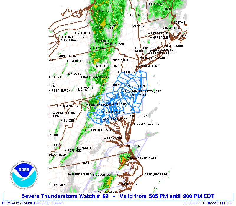
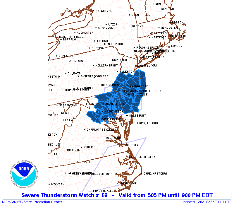
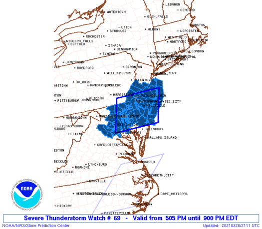
Severe Thunderstorm Watch Number 69
NWS Storm Prediction Center Norman OK
505 PM EDT Sun Mar 28 2021
The NWS Storm Prediction Center has issued a
* Severe Thunderstorm Watch for portions of
District Of Columbia
Delaware
Eastern Maryland
Southern New Jersey
Extreme southeastern Pennsylvania
Northeastern Virginia
Coastal Waters
* Effective this Sunday afternoon and evening from 505 PM until
900 PM EDT.
* Primary threats include...
Scattered damaging wind gusts to 70 mph possible
A tornado or two possible
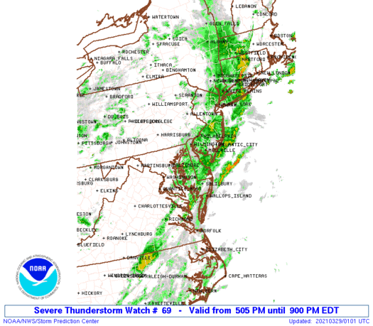
SUMMARY...A narrow band of shallow convection along a cold front
will likely persist while moving eastward from Maryland and Virginia
into New Jersey and Delaware the remainder of this afternoon into
this evening. A few damaging gusts will be the main threat, though
a brief tornado with embedded circulations cannot be ruled out.
The severe thunderstorm watch area is approximately along and 70
statute miles east and west of a line from 10 miles north of
Philadelphia PA to 50 miles south southwest of Dover DE. For a
complete depiction of the watch see the associated watch outline
update (WOUS64 KWNS WOU9).
PRECAUTIONARY/PREPAREDNESS ACTIONS...
REMEMBER...A Severe Thunderstorm Watch means conditions are
favorable for severe thunderstorms in and close to the watch area.
Persons in these areas should be on the lookout for threatening
weather conditions and listen for later statements and possible
warnings. Severe thunderstorms can and occasionally do produce
tornadoes.
&&
OTHER WATCH INFORMATION...CONTINUE...WW 68...
AVIATION...A few severe thunderstorms with hail surface and aloft to
0.5 inches. Extreme turbulence and surface wind gusts to 60 knots. A
few cumulonimbi with maximum tops to 400. Mean storm motion vector
27040.
...Thompson

   SEL9

   URGENT - IMMEDIATE BROADCAST REQUESTED
   Severe Thunderstorm Watch Number 69
   NWS Storm Prediction Center Norman OK
   505 PM EDT Sun Mar 28 2021

   The NWS Storm Prediction Center has issued a

   * Severe Thunderstorm Watch for portions of
     District Of Columbia
     Delaware
     Eastern Maryland
     Southern New Jersey
     Extreme southeastern Pennsylvania
     Northeastern Virginia
     Coastal Waters

   * Effective this Sunday afternoon and evening from 505 PM until
     900 PM EDT.

   * Primary threats include...
     Scattered damaging wind gusts to 70 mph possible
     A tornado or two possible

   SUMMARY...A narrow band of shallow convection along a cold front
   will likely persist while moving eastward from Maryland and Virginia
   into New Jersey and Delaware the remainder of this afternoon into
   this evening.  A few damaging gusts will be the main threat, though
   a brief tornado with embedded circulations cannot be ruled out.

   The severe thunderstorm watch area is approximately along and 70
   statute miles east and west of a line from 10 miles north of
   Philadelphia PA to 50 miles south southwest of Dover DE. For a
   complete depiction of the watch see the associated watch outline
   update (WOUS64 KWNS WOU9).

   PRECAUTIONARY/PREPAREDNESS ACTIONS...

   REMEMBER...A Severe Thunderstorm Watch means conditions are
   favorable for severe thunderstorms in and close to the watch area.
   Persons in these areas should be on the lookout for threatening
   weather conditions and listen for later statements and possible
   warnings. Severe thunderstorms can and occasionally do produce
   tornadoes.

   &&

   OTHER WATCH INFORMATION...CONTINUE...WW 68...

   AVIATION...A few severe thunderstorms with hail surface and aloft to
   0.5 inches. Extreme turbulence and surface wind gusts to 60 knots. A
   few cumulonimbi with maximum tops to 400. Mean storm motion vector
   27040.

   ...Thompson
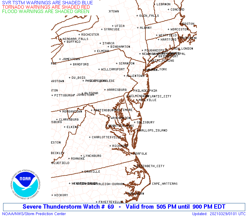
 Note:
The Aviation Watch (SAW) product is an approximation to the watch area.
The actual watch is depicted by the shaded areas.
Note:
The Aviation Watch (SAW) product is an approximation to the watch area.
The actual watch is depicted by the shaded areas.
   SAW9
   WW 69 SEVERE TSTM DC DE MD NJ PA VA CW 282105Z - 290100Z
   AXIS..70 STATUTE MILES EAST AND WEST OF LINE..
   10N PHL/PHILADELPHIA PA/ - 50SSW DOV/DOVER DE/
   ..AVIATION COORDS.. 60NM E/W /39WNW CYN - 16WNW SBY/
   HAIL SURFACE AND ALOFT..0.5 INCH. WIND GUSTS..60 KNOTS.
   MAX TOPS TO 400. MEAN STORM MOTION VECTOR 27040.

   LAT...LON 40007393 38457453 38457712 40007657

   THIS IS AN APPROXIMATION TO THE WATCH AREA.  FOR A
   COMPLETE DEPICTION OF THE WATCH SEE WOUS64 KWNS
   FOR WOU9.
Watch 69 Status Report Messages:
STATUS REPORT #3 ON WW 69

VALID 290025Z - 290140Z

SEVERE WEATHER THREAT CONTINUES RIGHT OF A LINE FROM 20 SE NHK TO
20 NNE NHK TO 30 NE NHK TO 25 SSE DOV TO 30 SSW ACY TO 10 E ACY
TO 20 ESE NEL TO 10 S JFK.

..JEWELL..03/29/21

ATTN...WFO...LWX...PHI...

&&

STATUS REPORT FOR WS 69

SEVERE WEATHER THREAT CONTINUES FOR THE FOLLOWING AREAS

DEC005-290140-

DE
.    DELAWARE COUNTIES INCLUDED ARE

SUSSEX
$$


ANZ450-451-452-453-454-455-290140-

CW

.    ADJACENT COASTAL WATERS INCLUDED ARE

COASTAL WATERS FROM SANDY HOOK TO MANASQUAN INLET NJ OUT 20 NM

COASTAL WATERS FROM MANASQUAN INLET TO LITTLE EGG INLET NJ OUT 20
NM

COASTAL WATERS FROM LITTLE EGG INLET TO GREAT EGG INLET NJ OUT 20
NM

COASTAL WATERS FROM GREAT EGG INLET TO CAPE MAY NJ OUT 20 NM

COASTAL WATERS FROM CAPE MAY NJ TO CAPE HENLOPEN DE OUT 20 NM

COASTAL WATERS FROM CAPE HENLOPEN TO FENWICK ISLAND DE OUT 20 NM

$$
THE WATCH STATUS MESSAGE IS FOR GUIDANCE PURPOSES ONLY.  PLEASE
REFER TO WATCH COUNTY NOTIFICATION STATEMENTS FOR OFFICIAL
INFORMATION ON COUNTIES...INDEPENDENT CITIES AND MARINE ZONES
CLEARED FROM SEVERE THUNDERSTORM AND TORNADO WATCHES.
$$

STATUS REPORT #2 ON WW 69

VALID 282330Z - 290040Z

SEVERE WEATHER THREAT CONTINUES RIGHT OF A LINE FROM 45 N RIC TO
25 SSE DCA TO 25 E DCA TO 30 WSW DOV TO 10 NNW DOV TO 15 SSE PHL
TO 20 NNE TTN TO 20 NW EWR.

FOR ADDITIONAL INFORMATION SEE MESOSCALE DISCUSSION 303

..JEWELL..03/28/21

ATTN...WFO...LWX...PHI...

&&

STATUS REPORT FOR WS 69

SEVERE WEATHER THREAT CONTINUES FOR THE FOLLOWING AREAS

DEC001-005-290040-

DE
.    DELAWARE COUNTIES INCLUDED ARE

KENT		     SUSSEX
$$


MDC009-011-017-037-041-290040-

MD
.    MARYLAND COUNTIES INCLUDED ARE

CALVERT 	     CAROLINE		 CHARLES
ST. MARYS	     TALBOT
$$


NJC001-005-007-009-011-015-021-025-029-033-290040-

NJ
.    NEW JERSEY COUNTIES INCLUDED ARE

ATLANTIC	     BURLINGTON 	 CAMDEN
CAPE MAY	     CUMBERLAND 	 GLOUCESTER
MERCER		     MONMOUTH		 OCEAN
SALEM
$$


ANZ431-450-451-452-453-454-455-533-534-536-537-540-541-542-
290040-

CW

.    ADJACENT COASTAL WATERS INCLUDED ARE

DELAWARE BAY WATERS SOUTH OF EAST POINT NJ TO SLAUGHTER BEACH DE

COASTAL WATERS FROM SANDY HOOK TO MANASQUAN INLET NJ OUT 20 NM

COASTAL WATERS FROM MANASQUAN INLET TO LITTLE EGG INLET NJ OUT 20
NM

COASTAL WATERS FROM LITTLE EGG INLET TO GREAT EGG INLET NJ OUT 20
NM

COASTAL WATERS FROM GREAT EGG INLET TO CAPE MAY NJ OUT 20 NM

COASTAL WATERS FROM CAPE MAY NJ TO CAPE HENLOPEN DE OUT 20 NM

COASTAL WATERS FROM CAPE HENLOPEN TO FENWICK ISLAND DE OUT 20 NM

CHESAPEAKE BAY FROM NORTH BEACH TO DRUM POINT MD

CHESAPEAKE BAY FROM DRUM POINT MD TO SMITH POINT VA

TIDAL POTOMAC FROM INDIAN HEAD TO COBB ISLAND MD

TIDAL POTOMAC FROM COBB ISLAND MD TO SMITH POINT VA

EASTERN BAY

CHOPTANK RIVER TO CAMBRIDGE MD AND THE LITTLE CHOPTANK RIVER

PATUXENT RIVER TO BROOMES ISLAND MD

$$
THE WATCH STATUS MESSAGE IS FOR GUIDANCE PURPOSES ONLY.  PLEASE
REFER TO WATCH COUNTY NOTIFICATION STATEMENTS FOR OFFICIAL
INFORMATION ON COUNTIES...INDEPENDENT CITIES AND MARINE ZONES
CLEARED FROM SEVERE THUNDERSTORM AND TORNADO WATCHES.
$$

STATUS REPORT #1 ON WW 69

VALID 282240Z - 282340Z

SEVERE WEATHER THREAT CONTINUES RIGHT OF A LINE FROM 45 E CHO TO
25 SW DCA TO 15 W DCA TO 15 SW BWI TO 15 E BWI TO 20 WSW ILG TO
15 NW ILG TO 15 SW ABE.

..JEWELL..03/28/21

ATTN...WFO...LWX...PHI...

&&

STATUS REPORT FOR WS 69

SEVERE WEATHER THREAT CONTINUES FOR THE FOLLOWING AREAS

DEC001-003-005-282340-

DE
.    DELAWARE COUNTIES INCLUDED ARE

KENT		     NEW CASTLE 	 SUSSEX
$$


DCC001-282340-

DC
.    DISTRICT OF COLUMBIA COUNTIES INCLUDED ARE

DISTRICT OF COLUMBIA
$$


MDC003-009-011-015-017-029-033-035-041-282340-

MD
.    MARYLAND COUNTIES INCLUDED ARE

ANNE ARUNDEL	     CALVERT		 CAROLINE
CECIL		     CHARLES		 KENT
PRINCE GEORGES	     QUEEN ANNE'S	 TALBOT
$$


NJC001-005-007-009-011-015-021-025-029-033-282340-

NJ
.    NEW JERSEY COUNTIES INCLUDED ARE

ATLANTIC	     BURLINGTON 	 CAMDEN
CAPE MAY	     CUMBERLAND 	 GLOUCESTER
MERCER		     MONMOUTH		 OCEAN
SALEM
$$


PAC017-029-045-091-101-282340-

PA
.    PENNSYLVANIA COUNTIES INCLUDED ARE

BUCKS		     CHESTER		 DELAWARE
MONTGOMERY	     PHILADELPHIA
$$


VAC013-059-179-510-610-282340-

VA
.    VIRGINIA COUNTIES INCLUDED ARE

ARLINGTON	     FAIRFAX		 STAFFORD


VIRGINIA INDEPENDENT CITIES INCLUDED ARE

ALEXANDRIA	     FALLS CHURCH
$$


ANZ430-431-450-451-452-453-454-455-532-533-535-539-540-541-542-
282340-

CW

.    ADJACENT COASTAL WATERS INCLUDED ARE

DELAWARE BAY WATERS NORTH OF EAST POINT NJ TO SLAUGHTER BEACH DE

DELAWARE BAY WATERS SOUTH OF EAST POINT NJ TO SLAUGHTER BEACH DE

COASTAL WATERS FROM SANDY HOOK TO MANASQUAN INLET NJ OUT 20 NM

COASTAL WATERS FROM MANASQUAN INLET TO LITTLE EGG INLET NJ OUT 20
NM

COASTAL WATERS FROM LITTLE EGG INLET TO GREAT EGG INLET NJ OUT 20
NM

COASTAL WATERS FROM GREAT EGG INLET TO CAPE MAY NJ OUT 20 NM

COASTAL WATERS FROM CAPE MAY NJ TO CAPE HENLOPEN DE OUT 20 NM

COASTAL WATERS FROM CAPE HENLOPEN TO FENWICK ISLAND DE OUT 20 NM

CHESAPEAKE BAY FROM SANDY POINT TO NORTH BEACH MD

CHESAPEAKE BAY FROM NORTH BEACH TO DRUM POINT MD

TIDAL POTOMAC FROM KEY BRIDGE TO INDIAN HEAD MD

CHESTER RIVER TO QUEENSTOWN MD

EASTERN BAY

CHOPTANK RIVER TO CAMBRIDGE MD AND THE LITTLE CHOPTANK RIVER

PATUXENT RIVER TO BROOMES ISLAND MD

$$
THE WATCH STATUS MESSAGE IS FOR GUIDANCE PURPOSES ONLY.  PLEASE
REFER TO WATCH COUNTY NOTIFICATION STATEMENTS FOR OFFICIAL
INFORMATION ON COUNTIES...INDEPENDENT CITIES AND MARINE ZONES
CLEARED FROM SEVERE THUNDERSTORM AND TORNADO WATCHES.
$$
Note:
Click for Complete Product Text.
Tornadoes
Probability of 2 or more tornadoes
|
Low (20%)
|
Probability of 1 or more strong (EF2-EF5) tornadoes
|
Low (5%)
|
Wind
Probability of 10 or more severe wind events
|
Mod (40%)
|
Probability of 1 or more wind events > 65 knots
|
Low (20%)
|
Hail
Probability of 10 or more severe hail events
|
Low (<5%)
|
Probability of 1 or more hailstones > 2 inches
|
Low (<5%)
|
Combined Severe Hail/Wind
Probability of 6 or more combined severe hail/wind events
|
Mod (50%)
|
For each watch, probabilities for particular events inside the watch
(listed above in each table) are determined by the issuing forecaster.
The "Low" category contains probability values ranging from less than 2%
to 20% (EF2-EF5 tornadoes), less than 5% to 20% (all other probabilities),
"Moderate" from 30% to 60%, and "High" from 70% to greater than 95%.
High values are bolded and lighter in color to provide awareness of
an increased threat for a particular event.


 @NWSSPC