 Note:
The expiration time in the watch graphic is amended if the watch is
replaced, cancelled or extended.
Note:
Note:
The expiration time in the watch graphic is amended if the watch is
replaced, cancelled or extended.
Note: Click for
Watch Status Reports.
SEL0
URGENT - IMMEDIATE BROADCAST REQUESTED
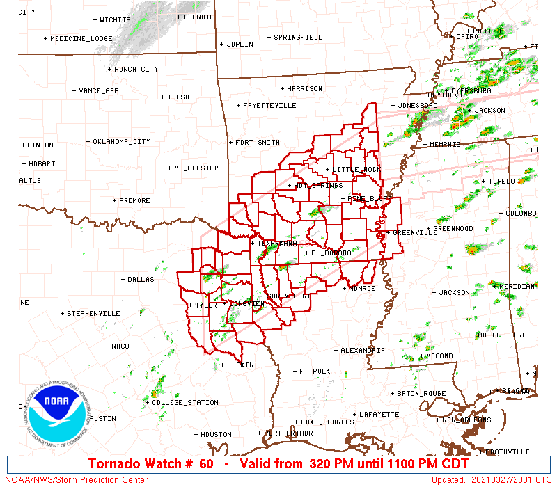
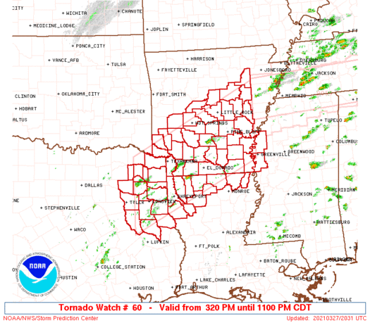
Tornado Watch Number 60
NWS Storm Prediction Center Norman OK
320 PM CDT Sat Mar 27 2021
The NWS Storm Prediction Center has issued a
* Tornado Watch for portions of
Southern and eastern Arkansas
Northern Louisiana
Extreme northwestern Mississippi
Northeastern Texas
* Effective this Saturday afternoon and evening from 320 PM until
1100 PM CDT.
* Primary threats include...
A few tornadoes and a couple intense tornadoes likely
Widespread large hail and scattered very large hail events to 3
inches in diameter likely
Scattered damaging winds likely with isolated significant gusts
to 75 mph possible
SUMMARY...Scattered supercell development is expected this afternoon
from northeastern Texas across northwestern Louisiana into southern
and eastern Arkansas. The storms will persist through late evening
and expand in coverage, with the potential to produce very large
hail, damaging winds, and several tornadoes. A couple of strong
tornadoes will be possible, mainly later this evening across
southeast Arkansas.
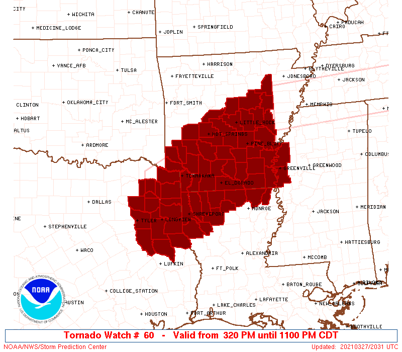
The tornado watch area is approximately along and 75 statute miles
north and south of a line from 55 miles east northeast of Pine Bluff
AR to 25 miles west northwest of Longview TX. For a complete
depiction of the watch see the associated watch outline update
(WOUS64 KWNS WOU0).
PRECAUTIONARY/PREPAREDNESS ACTIONS...
REMEMBER...A Tornado Watch means conditions are favorable for
tornadoes and severe thunderstorms in and close to the watch
area. Persons in these areas should be on the lookout for
threatening weather conditions and listen for later statements
and possible warnings.
&&
OTHER WATCH INFORMATION...CONTINUE...WW 58...WW 59...
AVIATION...Tornadoes and a few severe thunderstorms with hail
surface and aloft to 3 inches. Extreme turbulence and surface wind
gusts to 65 knots. A few cumulonimbi with maximum tops to 550. Mean
storm motion vector 24030.
...Thompson
   SEL0

   URGENT - IMMEDIATE BROADCAST REQUESTED
   Tornado Watch Number 60
   NWS Storm Prediction Center Norman OK
   320 PM CDT Sat Mar 27 2021

   The NWS Storm Prediction Center has issued a

   * Tornado Watch for portions of
     Southern and eastern Arkansas
     Northern Louisiana
     Extreme northwestern Mississippi
     Northeastern Texas

   * Effective this Saturday afternoon and evening from 320 PM until
     1100 PM CDT.

   * Primary threats include...
     A few tornadoes and a couple intense tornadoes likely
     Widespread large hail and scattered very large hail events to 3
       inches in diameter likely
     Scattered damaging winds likely with isolated significant gusts
       to 75 mph possible

   SUMMARY...Scattered supercell development is expected this afternoon
   from northeastern Texas across northwestern Louisiana into southern
   and eastern Arkansas.  The storms will persist through late evening
   and expand in coverage, with the potential to produce very large
   hail, damaging winds, and several tornadoes.  A couple of strong
   tornadoes will be possible, mainly later this evening across
   southeast Arkansas.

   The tornado watch area is approximately along and 75 statute miles
   north and south of a line from 55 miles east northeast of Pine Bluff
   AR to 25 miles west northwest of Longview TX. For a complete
   depiction of the watch see the associated watch outline update
   (WOUS64 KWNS WOU0).

   PRECAUTIONARY/PREPAREDNESS ACTIONS...

   REMEMBER...A Tornado Watch means conditions are favorable for
   tornadoes and severe thunderstorms in and close to the watch
   area. Persons in these areas should be on the lookout for
   threatening weather conditions and listen for later statements
   and possible warnings.

   &&

   OTHER WATCH INFORMATION...CONTINUE...WW 58...WW 59...

   AVIATION...Tornadoes and a few severe thunderstorms with hail
   surface and aloft to 3 inches. Extreme turbulence and surface wind
   gusts to 65 knots. A few cumulonimbi with maximum tops to 550. Mean
   storm motion vector 24030.

   ...Thompson
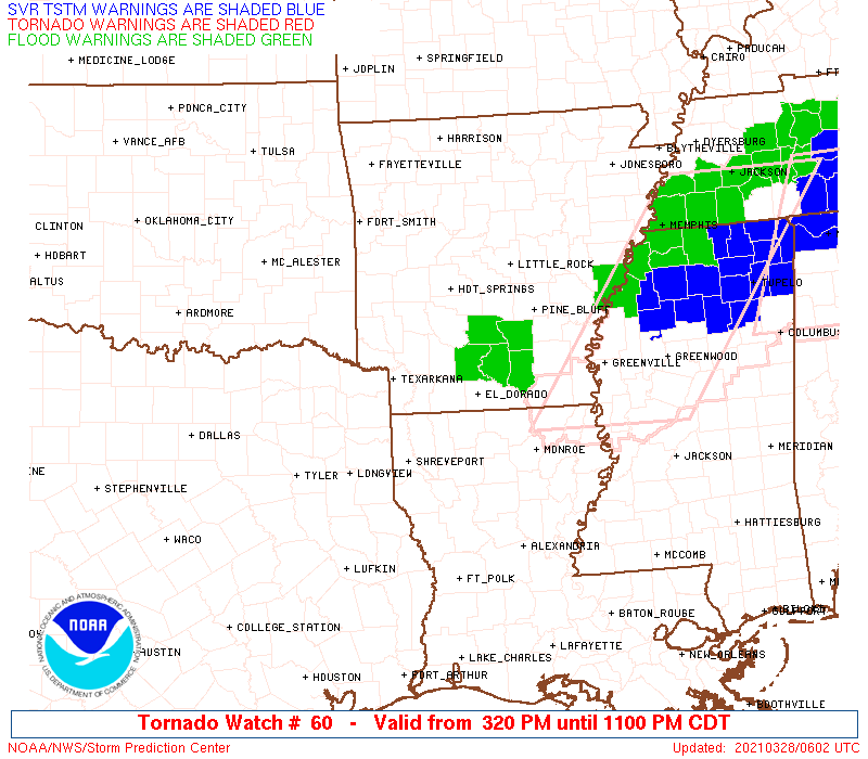
 Note:
The Aviation Watch (SAW) product is an approximation to the watch area.
The actual watch is depicted by the shaded areas.
Note:
The Aviation Watch (SAW) product is an approximation to the watch area.
The actual watch is depicted by the shaded areas.
SAW0
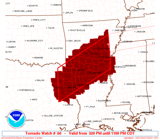
WW 60 TORNADO AR LA MS TX 272020Z - 280400Z
AXIS..75 STATUTE MILES NORTH AND SOUTH OF LINE..
55ENE PBF/PINE BLUFF AR/ - 25WNW GGG/LONGVIEW TX/
..AVIATION COORDS.. 65NM N/S /58ESE LIT - 19WNW GGG/
HAIL SURFACE AND ALOFT..3 INCHES. WIND GUSTS..65 KNOTS.
MAX TOPS TO 550. MEAN STORM MOTION VECTOR 24030.
LAT...LON 33399104 31439512 33599512 35569104
THIS IS AN APPROXIMATION TO THE WATCH AREA. FOR A
COMPLETE DEPICTION OF THE WATCH SEE WOUS64 KWNS
FOR WOU0.
Watch 60 Status Report Messages:
STATUS REPORT #5 ON WW 60

VALID 280245Z - 280340Z

SEVERE WEATHER THREAT CONTINUES RIGHT OF A LINE FROM 20 S TYR TO
GGG TO 40 NNE GGG TO 25 SW TXK TO 40 WSW PBF TO 25 SSW LIT TO 30
NE PBF TO 60 WSW MEM.

..JEWELL..03/28/21

ATTN...WFO...LZK...JAN...SHV...

&&

STATUS REPORT FOR WT 60

SEVERE WEATHER THREAT CONTINUES FOR THE FOLLOWING AREAS

ARC001-011-013-025-027-039-041-043-053-069-073-079-091-095-099-
103-139-280340-

AR
.    ARKANSAS COUNTIES INCLUDED ARE

ARKANSAS	     BRADLEY		 CALHOUN
CLEVELAND	     COLUMBIA		 DALLAS
DESHA		     DREW		 GRANT
JEFFERSON	     LAFAYETTE		 LINCOLN
MILLER		     MONROE		 NEVADA
OUACHITA	     UNION
$$


LAC013-015-017-027-031-061-081-111-119-280340-

LA
.    LOUISIANA PARISHES INCLUDED ARE

BIENVILLE	     BOSSIER		 CADDO
CLAIBORNE	     DE SOTO		 LINCOLN
RED RIVER	     UNION		 WEBSTER
$$


TXC067-073-203-315-347-365-401-419-280340-

TX
.    TEXAS COUNTIES INCLUDED ARE

CASS		     CHEROKEE		 HARRISON
MARION		     NACOGDOCHES	 PANOLA
RUSK		     SHELBY
$$


THE WATCH STATUS MESSAGE IS FOR GUIDANCE PURPOSES ONLY.  PLEASE
REFER TO WATCH COUNTY NOTIFICATION STATEMENTS FOR OFFICIAL
INFORMATION ON COUNTIES...INDEPENDENT CITIES AND MARINE ZONES
CLEARED FROM SEVERE THUNDERSTORM AND TORNADO WATCHES.
$$

STATUS REPORT #4 ON WW 60

VALID 280205Z - 280340Z

SEVERE WEATHER THREAT CONTINUES RIGHT OF A LINE FROM 25 S TYR TO
20 ESE TYR TO 35 N GGG TO 20 SW TXK TO 30 SSW HOT TO 25 SSW LIT
TO 30 NE PBF TO 55 SSE BVX TO 50 SSW JBR.

..JEWELL..03/28/21

ATTN...WFO...LZK...JAN...SHV...

&&

STATUS REPORT FOR WT 60

SEVERE WEATHER THREAT CONTINUES FOR THE FOLLOWING AREAS

ARC001-011-013-019-025-027-039-041-043-053-057-069-073-079-091-
095-099-103-139-280340-

AR
.    ARKANSAS COUNTIES INCLUDED ARE

ARKANSAS	     BRADLEY		 CALHOUN
CLARK		     CLEVELAND		 COLUMBIA
DALLAS		     DESHA		 DREW
GRANT		     HEMPSTEAD		 JEFFERSON
LAFAYETTE	     LINCOLN		 MILLER
MONROE		     NEVADA		 OUACHITA
UNION
$$


LAC013-015-017-027-031-061-081-111-119-280340-

LA
.    LOUISIANA PARISHES INCLUDED ARE

BIENVILLE	     BOSSIER		 CADDO
CLAIBORNE	     DE SOTO		 LINCOLN
RED RIVER	     UNION		 WEBSTER
$$


TXC067-073-183-203-315-347-365-401-419-280340-

TX
.    TEXAS COUNTIES INCLUDED ARE

CASS		     CHEROKEE		 GREGG
HARRISON	     MARION		 NACOGDOCHES
PANOLA		     RUSK		 SHELBY
$$


THE WATCH STATUS MESSAGE IS FOR GUIDANCE PURPOSES ONLY.  PLEASE
REFER TO WATCH COUNTY NOTIFICATION STATEMENTS FOR OFFICIAL
INFORMATION ON COUNTIES...INDEPENDENT CITIES AND MARINE ZONES
CLEARED FROM SEVERE THUNDERSTORM AND TORNADO WATCHES.
$$

STATUS REPORT #3 ON WW 60

VALID 280055Z - 280140Z

THE SEVERE WEATHER THREAT CONTINUES ACROSS THE ENTIRE WATCH AREA.

FOR ADDITIONAL INFORMATION SEE MESOSCALE DISCUSSION 287

..JEWELL..03/28/21

ATTN...WFO...LZK...JAN...SHV...

&&

STATUS REPORT FOR WT 60

SEVERE WEATHER THREAT CONTINUES FOR THE FOLLOWING AREAS

ARC001-003-011-013-017-019-025-027-039-041-043-045-051-053-057-
059-061-067-069-073-079-081-085-091-095-097-099-103-105-109-117-
119-125-133-139-145-147-280140-

AR
.    ARKANSAS COUNTIES INCLUDED ARE

ARKANSAS	     ASHLEY		 BRADLEY
CALHOUN 	     CHICOT		 CLARK
CLEVELAND	     COLUMBIA		 DALLAS
DESHA		     DREW		 FAULKNER
GARLAND 	     GRANT		 HEMPSTEAD
HOT SPRING	     HOWARD		 JACKSON
JEFFERSON	     LAFAYETTE		 LINCOLN
LITTLE RIVER	     LONOKE		 MILLER
MONROE		     MONTGOMERY 	 NEVADA
OUACHITA	     PERRY		 PIKE
PRAIRIE 	     PULASKI		 SALINE
SEVIER		     UNION		 WHITE
WOODRUFF
$$


LAC013-015-017-027-031-061-067-081-111-119-123-280140-

LA
.    LOUISIANA PARISHES INCLUDED ARE

BIENVILLE	     BOSSIER		 CADDO
CLAIBORNE	     DE SOTO		 LINCOLN
MOREHOUSE	     RED RIVER		 UNION
WEBSTER 	     WEST CARROLL
$$


MSC011-151-280140-

MS
.    MISSISSIPPI COUNTIES INCLUDED ARE

BOLIVAR 	     WASHINGTON
$$


TXC037-063-067-073-159-183-203-315-343-347-365-401-419-423-449-
459-499-280140-

TX
.    TEXAS COUNTIES INCLUDED ARE

BOWIE		     CAMP		 CASS
CHEROKEE	     FRANKLIN		 GREGG
HARRISON	     MARION		 MORRIS
NACOGDOCHES	     PANOLA		 RUSK
SHELBY		     SMITH		 TITUS
UPSHUR		     WOOD
$$


THE WATCH STATUS MESSAGE IS FOR GUIDANCE PURPOSES ONLY.  PLEASE
REFER TO WATCH COUNTY NOTIFICATION STATEMENTS FOR OFFICIAL
INFORMATION ON COUNTIES...INDEPENDENT CITIES AND MARINE ZONES
CLEARED FROM SEVERE THUNDERSTORM AND TORNADO WATCHES.
$$

STATUS REPORT #2 ON WW 60

VALID 272230Z - 272340Z

THE SEVERE WEATHER THREAT CONTINUES ACROSS THE ENTIRE WATCH AREA.

..JEWELL..03/27/21

ATTN...WFO...LZK...JAN...SHV...

&&

STATUS REPORT FOR WT 60

SEVERE WEATHER THREAT CONTINUES FOR THE FOLLOWING AREAS

ARC001-003-011-013-017-019-025-027-039-041-043-045-051-053-057-
059-061-067-069-073-079-081-085-091-095-097-099-103-105-109-117-
119-125-133-139-145-147-272340-

AR
.    ARKANSAS COUNTIES INCLUDED ARE

ARKANSAS	     ASHLEY		 BRADLEY
CALHOUN 	     CHICOT		 CLARK
CLEVELAND	     COLUMBIA		 DALLAS
DESHA		     DREW		 FAULKNER
GARLAND 	     GRANT		 HEMPSTEAD
HOT SPRING	     HOWARD		 JACKSON
JEFFERSON	     LAFAYETTE		 LINCOLN
LITTLE RIVER	     LONOKE		 MILLER
MONROE		     MONTGOMERY 	 NEVADA
OUACHITA	     PERRY		 PIKE
PRAIRIE 	     PULASKI		 SALINE
SEVIER		     UNION		 WHITE
WOODRUFF
$$


LAC013-015-017-027-031-061-067-081-111-119-123-272340-

LA
.    LOUISIANA PARISHES INCLUDED ARE

BIENVILLE	     BOSSIER		 CADDO
CLAIBORNE	     DE SOTO		 LINCOLN
MOREHOUSE	     RED RIVER		 UNION
WEBSTER 	     WEST CARROLL
$$


MSC011-151-272340-

MS
.    MISSISSIPPI COUNTIES INCLUDED ARE

BOLIVAR 	     WASHINGTON
$$


TXC037-063-067-073-159-183-203-315-343-347-365-401-419-423-449-
459-499-272340-

TX
.    TEXAS COUNTIES INCLUDED ARE

BOWIE		     CAMP		 CASS
CHEROKEE	     FRANKLIN		 GREGG
HARRISON	     MARION		 MORRIS
NACOGDOCHES	     PANOLA		 RUSK
SHELBY		     SMITH		 TITUS
UPSHUR		     WOOD
$$


THE WATCH STATUS MESSAGE IS FOR GUIDANCE PURPOSES ONLY.  PLEASE
REFER TO WATCH COUNTY NOTIFICATION STATEMENTS FOR OFFICIAL
INFORMATION ON COUNTIES...INDEPENDENT CITIES AND MARINE ZONES
CLEARED FROM SEVERE THUNDERSTORM AND TORNADO WATCHES.
$$

STATUS REPORT #1 ON WW 60

VALID 272140Z - 272240Z

THE SEVERE WEATHER THREAT CONTINUES ACROSS THE ENTIRE WATCH AREA.

..JEWELL..03/27/21

ATTN...WFO...LZK...JAN...SHV...

&&

STATUS REPORT FOR WT 60

SEVERE WEATHER THREAT CONTINUES FOR THE FOLLOWING AREAS

ARC001-003-011-013-017-019-025-027-039-041-043-045-051-053-057-
059-061-067-069-073-079-081-085-091-095-097-099-103-105-109-117-
119-125-133-139-145-147-272240-

AR
.    ARKANSAS COUNTIES INCLUDED ARE

ARKANSAS	     ASHLEY		 BRADLEY
CALHOUN 	     CHICOT		 CLARK
CLEVELAND	     COLUMBIA		 DALLAS
DESHA		     DREW		 FAULKNER
GARLAND 	     GRANT		 HEMPSTEAD
HOT SPRING	     HOWARD		 JACKSON
JEFFERSON	     LAFAYETTE		 LINCOLN
LITTLE RIVER	     LONOKE		 MILLER
MONROE		     MONTGOMERY 	 NEVADA
OUACHITA	     PERRY		 PIKE
PRAIRIE 	     PULASKI		 SALINE
SEVIER		     UNION		 WHITE
WOODRUFF
$$


LAC013-015-017-027-031-061-067-081-111-119-123-272240-

LA
.    LOUISIANA PARISHES INCLUDED ARE

BIENVILLE	     BOSSIER		 CADDO
CLAIBORNE	     DE SOTO		 LINCOLN
MOREHOUSE	     RED RIVER		 UNION
WEBSTER 	     WEST CARROLL
$$


MSC011-151-272240-

MS
.    MISSISSIPPI COUNTIES INCLUDED ARE

BOLIVAR 	     WASHINGTON
$$


TXC037-063-067-073-159-183-203-315-343-347-365-401-419-423-449-
459-499-272240-

TX
.    TEXAS COUNTIES INCLUDED ARE

BOWIE		     CAMP		 CASS
CHEROKEE	     FRANKLIN		 GREGG
HARRISON	     MARION		 MORRIS
NACOGDOCHES	     PANOLA		 RUSK
SHELBY		     SMITH		 TITUS
UPSHUR		     WOOD
$$


THE WATCH STATUS MESSAGE IS FOR GUIDANCE PURPOSES ONLY.  PLEASE
REFER TO WATCH COUNTY NOTIFICATION STATEMENTS FOR OFFICIAL
INFORMATION ON COUNTIES...INDEPENDENT CITIES AND MARINE ZONES
CLEARED FROM SEVERE THUNDERSTORM AND TORNADO WATCHES.
$$
Note:
Click for Complete Product Text.
Tornadoes
Probability of 2 or more tornadoes
|
High (70%)
|
Probability of 1 or more strong (EF2-EF5) tornadoes
|
Mod (60%)
|
Wind
Probability of 10 or more severe wind events
|
High (70%)
|
Probability of 1 or more wind events > 65 knots
|
Mod (40%)
|
Hail
Probability of 10 or more severe hail events
|
High (90%)
|
Probability of 1 or more hailstones > 2 inches
|
High (80%)
|
Combined Severe Hail/Wind
Probability of 6 or more combined severe hail/wind events
|
High (>95%)
|
For each watch, probabilities for particular events inside the watch
(listed above in each table) are determined by the issuing forecaster.
The "Low" category contains probability values ranging from less than 2%
to 20% (EF2-EF5 tornadoes), less than 5% to 20% (all other probabilities),
"Moderate" from 30% to 60%, and "High" from 70% to greater than 95%.
High values are bolded and lighter in color to provide awareness of
an increased threat for a particular event.


 @NWSSPC