 Note:
The expiration time in the watch graphic is amended if the watch is
replaced, cancelled or extended.
Note:
Note:
The expiration time in the watch graphic is amended if the watch is
replaced, cancelled or extended.
Note: Click for
Watch Status Reports.
SEL9
URGENT - IMMEDIATE BROADCAST REQUESTED
Tornado Watch Number 59
NWS Storm Prediction Center Norman OK
145 PM CDT Sat Mar 27 2021
The NWS Storm Prediction Center has issued a
* Tornado Watch for portions of
Extreme northern Alabama
Extreme east central Arkansas
Northern Mississippi
Southern parts of western and middle Tennessee
* Effective this Saturday afternoon and evening from 145 PM until
900 PM CDT.
* Primary threats include...
Several tornadoes and a couple intense tornadoes likely
Scattered damaging winds and isolated significant gusts to 75
mph likely
Scattered large hail and isolated very large hail events to 3
inches in diameter likely
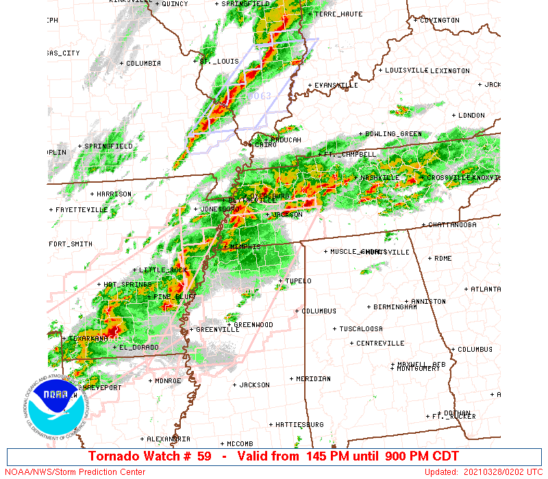
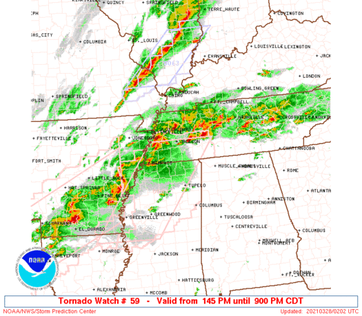
SUMMARY...Severe storm development is expected by mid afternoon and
storms will persist well into this evening. The storm environment
favors supercells capable of producing a couple of strong tornadoes
and very large hail near the size of baseballs. As storms cluster
more into the evening, the threat for damaging winds will increase,
including the potential for hurricane force gusts.
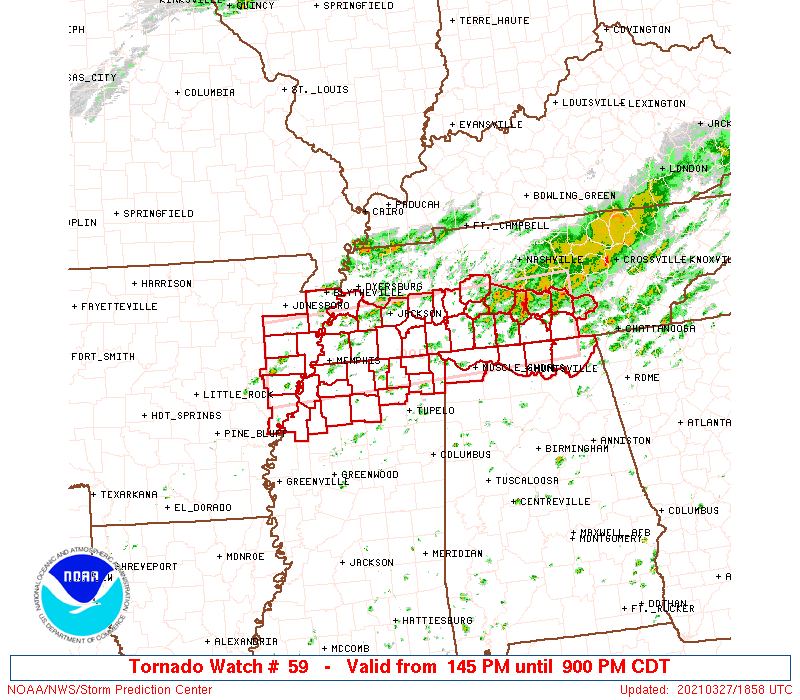
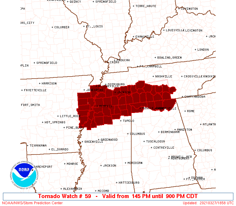
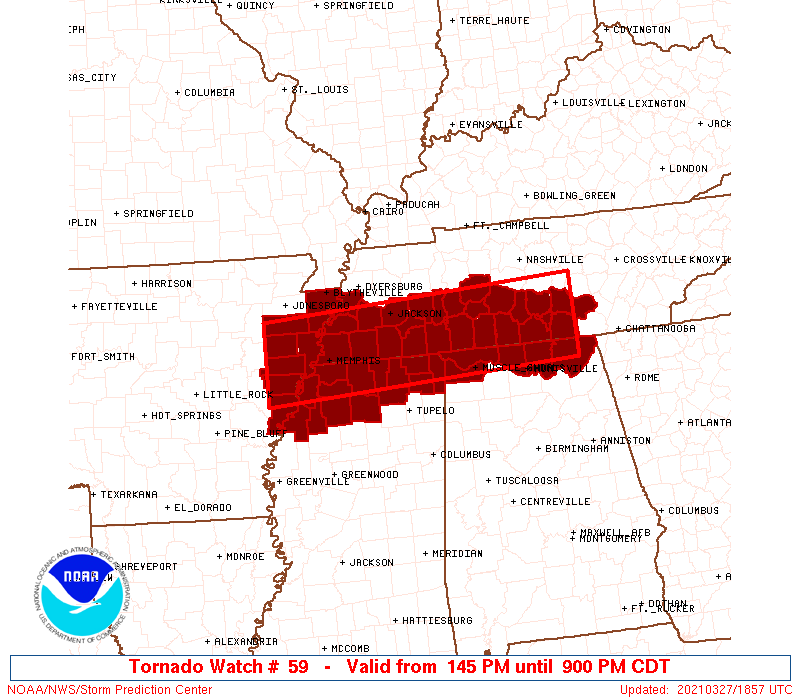
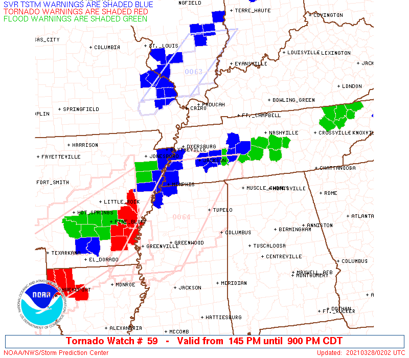
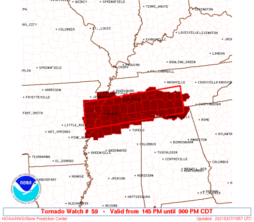
The tornado watch area is approximately along and 40 statute miles
north and south of a line from 105 miles east northeast of Muscle
Shoals AL to 60 miles west of Memphis TN. For a complete depiction
of the watch see the associated watch outline update (WOUS64 KWNS
WOU9).
PRECAUTIONARY/PREPAREDNESS ACTIONS...
REMEMBER...A Tornado Watch means conditions are favorable for
tornadoes and severe thunderstorms in and close to the watch
area. Persons in these areas should be on the lookout for
threatening weather conditions and listen for later statements
and possible warnings.
&&
OTHER WATCH INFORMATION...CONTINUE...WW 58...
AVIATION...Tornadoes and a few severe thunderstorms with hail
surface and aloft to 3 inches. Extreme turbulence and surface wind
gusts to 65 knots. A few cumulonimbi with maximum tops to 550. Mean
storm motion vector 24030.
...Thompson

   SEL9

   URGENT - IMMEDIATE BROADCAST REQUESTED
   Tornado Watch Number 59
   NWS Storm Prediction Center Norman OK
   145 PM CDT Sat Mar 27 2021

   The NWS Storm Prediction Center has issued a

   * Tornado Watch for portions of
     Extreme northern Alabama
     Extreme east central Arkansas
     Northern Mississippi
     Southern parts of western and middle Tennessee

   * Effective this Saturday afternoon and evening from 145 PM until
     900 PM CDT.

   * Primary threats include...
     Several tornadoes and a couple intense tornadoes likely
     Scattered damaging winds and isolated significant gusts to 75
       mph likely
     Scattered large hail and isolated very large hail events to 3
       inches in diameter likely

   SUMMARY...Severe storm development is expected by mid afternoon and
   storms will persist well into this evening.  The storm environment
   favors supercells capable of producing a couple of strong tornadoes
   and very large hail near the size of baseballs.  As storms cluster
   more into the evening, the threat for damaging winds will increase,
   including the potential for hurricane force gusts.

   The tornado watch area is approximately along and 40 statute miles
   north and south of a line from 105 miles east northeast of Muscle
   Shoals AL to 60 miles west of Memphis TN. For a complete depiction
   of the watch see the associated watch outline update (WOUS64 KWNS
   WOU9).

   PRECAUTIONARY/PREPAREDNESS ACTIONS...

   REMEMBER...A Tornado Watch means conditions are favorable for
   tornadoes and severe thunderstorms in and close to the watch
   area. Persons in these areas should be on the lookout for
   threatening weather conditions and listen for later statements
   and possible warnings.

   &&

   OTHER WATCH INFORMATION...CONTINUE...WW 58...

   AVIATION...Tornadoes and a few severe thunderstorms with hail
   surface and aloft to 3 inches. Extreme turbulence and surface wind
   gusts to 65 knots. A few cumulonimbi with maximum tops to 550. Mean
   storm motion vector 24030.

   ...Thompson
 Note:
The Aviation Watch (SAW) product is an approximation to the watch area.
The actual watch is depicted by the shaded areas.
Note:
The Aviation Watch (SAW) product is an approximation to the watch area.
The actual watch is depicted by the shaded areas.
   SAW9
   WW 59 TORNADO AL AR MS TN 271845Z - 280200Z
   AXIS..40 STATUTE MILES NORTH AND SOUTH OF LINE..
   105ENE MSL/MUSCLE SHOALS AL/ - 60W MEM/MEMPHIS TN/
   ..AVIATION COORDS.. 35NM N/S /43WNW GQO - 52W MEM/
   HAIL SURFACE AND ALOFT..3 INCHES. WIND GUSTS..65 KNOTS.
   MAX TOPS TO 550. MEAN STORM MOTION VECTOR 24030.

   LAT...LON 34748590 34469104 35619104 35908590

   THIS IS AN APPROXIMATION TO THE WATCH AREA.  FOR A
   COMPLETE DEPICTION OF THE WATCH SEE WOUS64 KWNS
   FOR WOU9.
Watch 59 Status Report Messages:
STATUS REPORT #4 ON WW 59

VALID 272230Z - 272340Z

THE SEVERE WEATHER THREAT CONTINUES ACROSS THE ENTIRE WATCH AREA.

..JEWELL..03/27/21

ATTN...WFO...HUN...MEG...OHX...

&&

STATUS REPORT FOR WT 59

SEVERE WEATHER THREAT CONTINUES FOR THE FOLLOWING AREAS

ALC033-071-077-083-089-272340-

AL
.    ALABAMA COUNTIES INCLUDED ARE

COLBERT 	     JACKSON		 LAUDERDALE
LIMESTONE	     MADISON
$$


ARC035-037-077-093-107-111-123-272340-

AR
.    ARKANSAS COUNTIES INCLUDED ARE

CRITTENDEN	     CROSS		 LEE
MISSISSIPPI	     PHILLIPS		 POINSETT
ST. FRANCIS
$$


MSC003-009-027-033-071-093-107-117-119-137-139-141-143-145-
272340-

MS
.    MISSISSIPPI COUNTIES INCLUDED ARE

ALCORN		     BENTON		 COAHOMA
DESOTO		     LAFAYETTE		 MARSHALL
PANOLA		     PRENTISS		 QUITMAN
TATE		     TIPPAH		 TISHOMINGO
TUNICA		     UNION
$$


TNC003-023-031-039-047-051-055-061-069-071-075-077-081-097-099-
101-103-109-113-117-119-127-135-157-167-181-272340-

TN
.    TENNESSEE COUNTIES INCLUDED ARE

BEDFORD 	     CHESTER		 COFFEE
DECATUR 	     FAYETTE		 FRANKLIN
GILES		     GRUNDY		 HARDEMAN
HARDIN		     HAYWOOD		 HENDERSON
HICKMAN 	     LAUDERDALE 	 LAWRENCE
LEWIS		     LINCOLN		 MCNAIRY
MADISON 	     MARSHALL		 MAURY
MOORE		     PERRY		 SHELBY
TIPTON		     WAYNE
$$


THE WATCH STATUS MESSAGE IS FOR GUIDANCE PURPOSES ONLY.  PLEASE
REFER TO WATCH COUNTY NOTIFICATION STATEMENTS FOR OFFICIAL
INFORMATION ON COUNTIES...INDEPENDENT CITIES AND MARINE ZONES
CLEARED FROM SEVERE THUNDERSTORM AND TORNADO WATCHES.
$$

STATUS REPORT #3 ON WW 59

VALID 272150Z - 272240Z

THE SEVERE WEATHER THREAT CONTINUES ACROSS THE ENTIRE WATCH AREA.

FOR ADDITIONAL INFORMATION SEE MESOSCALE DISCUSSION 282

..KARSTENS..03/27/21

ATTN...WFO...HUN...MEG...OHX...

&&

STATUS REPORT FOR WT 59

SEVERE WEATHER THREAT CONTINUES FOR THE FOLLOWING AREAS

ALC033-071-077-083-089-272240-

AL
.    ALABAMA COUNTIES INCLUDED ARE

COLBERT 	     JACKSON		 LAUDERDALE
LIMESTONE	     MADISON
$$


ARC035-037-077-093-107-111-123-272240-

AR
.    ARKANSAS COUNTIES INCLUDED ARE

CRITTENDEN	     CROSS		 LEE
MISSISSIPPI	     PHILLIPS		 POINSETT
ST. FRANCIS
$$


MSC003-009-027-033-071-093-107-117-119-137-139-141-143-145-
272240-

MS
.    MISSISSIPPI COUNTIES INCLUDED ARE

ALCORN		     BENTON		 COAHOMA
DESOTO		     LAFAYETTE		 MARSHALL
PANOLA		     PRENTISS		 QUITMAN
TATE		     TIPPAH		 TISHOMINGO
TUNICA		     UNION
$$


TNC003-023-031-039-047-051-055-061-069-071-075-077-081-097-099-
101-103-109-113-117-119-127-135-157-167-181-272240-

TN
.    TENNESSEE COUNTIES INCLUDED ARE

BEDFORD 	     CHESTER		 COFFEE
DECATUR 	     FAYETTE		 FRANKLIN
GILES		     GRUNDY		 HARDEMAN
HARDIN		     HAYWOOD		 HENDERSON
HICKMAN 	     LAUDERDALE 	 LAWRENCE
LEWIS		     LINCOLN		 MCNAIRY
MADISON 	     MARSHALL		 MAURY
MOORE		     PERRY		 SHELBY
TIPTON		     WAYNE
$$


THE WATCH STATUS MESSAGE IS FOR GUIDANCE PURPOSES ONLY.  PLEASE
REFER TO WATCH COUNTY NOTIFICATION STATEMENTS FOR OFFICIAL
INFORMATION ON COUNTIES...INDEPENDENT CITIES AND MARINE ZONES
CLEARED FROM SEVERE THUNDERSTORM AND TORNADO WATCHES.
$$

STATUS REPORT #2 ON WW 59

VALID 272100Z - 272240Z

THE SEVERE WEATHER THREAT CONTINUES ACROSS THE ENTIRE WATCH AREA.

FOR ADDITIONAL INFORMATION SEE MESOSCALE DISCUSSION 282

..GLEASON..03/27/21

ATTN...WFO...HUN...MEG...OHX...

&&

STATUS REPORT FOR WT 59

SEVERE WEATHER THREAT CONTINUES FOR THE FOLLOWING AREAS

ALC033-071-077-083-089-272240-

AL
.    ALABAMA COUNTIES INCLUDED ARE

COLBERT 	     JACKSON		 LAUDERDALE
LIMESTONE	     MADISON
$$


ARC035-037-077-093-107-111-123-272240-

AR
.    ARKANSAS COUNTIES INCLUDED ARE

CRITTENDEN	     CROSS		 LEE
MISSISSIPPI	     PHILLIPS		 POINSETT
ST. FRANCIS
$$


MSC003-009-027-033-071-093-107-117-119-137-139-141-143-145-
272240-

MS
.    MISSISSIPPI COUNTIES INCLUDED ARE

ALCORN		     BENTON		 COAHOMA
DESOTO		     LAFAYETTE		 MARSHALL
PANOLA		     PRENTISS		 QUITMAN
TATE		     TIPPAH		 TISHOMINGO
TUNICA		     UNION
$$


TNC003-023-031-039-047-051-055-061-069-071-075-077-081-097-099-
101-103-109-113-117-119-127-135-157-167-181-272240-

TN
.    TENNESSEE COUNTIES INCLUDED ARE

BEDFORD 	     CHESTER		 COFFEE
DECATUR 	     FAYETTE		 FRANKLIN
GILES		     GRUNDY		 HARDEMAN
HARDIN		     HAYWOOD		 HENDERSON
HICKMAN 	     LAUDERDALE 	 LAWRENCE
LEWIS		     LINCOLN		 MCNAIRY
MADISON 	     MARSHALL		 MAURY
MOORE		     PERRY		 SHELBY
TIPTON		     WAYNE
$$


THE WATCH STATUS MESSAGE IS FOR GUIDANCE PURPOSES ONLY.  PLEASE
REFER TO WATCH COUNTY NOTIFICATION STATEMENTS FOR OFFICIAL
INFORMATION ON COUNTIES...INDEPENDENT CITIES AND MARINE ZONES
CLEARED FROM SEVERE THUNDERSTORM AND TORNADO WATCHES.
$$

STATUS REPORT #1 ON WW 59

VALID 271945Z - 272040Z

THE SEVERE WEATHER THREAT CONTINUES ACROSS THE ENTIRE WATCH AREA.

..GLEASON..03/27/21

ATTN...WFO...HUN...MEG...OHX...

&&

STATUS REPORT FOR WT 59

SEVERE WEATHER THREAT CONTINUES FOR THE FOLLOWING AREAS

ALC033-071-077-083-089-272040-

AL
.    ALABAMA COUNTIES INCLUDED ARE

COLBERT 	     JACKSON		 LAUDERDALE
LIMESTONE	     MADISON
$$


ARC035-037-077-093-107-111-123-272040-

AR
.    ARKANSAS COUNTIES INCLUDED ARE

CRITTENDEN	     CROSS		 LEE
MISSISSIPPI	     PHILLIPS		 POINSETT
ST. FRANCIS
$$


MSC003-009-027-033-071-093-107-117-119-137-139-141-143-145-
272040-

MS
.    MISSISSIPPI COUNTIES INCLUDED ARE

ALCORN		     BENTON		 COAHOMA
DESOTO		     LAFAYETTE		 MARSHALL
PANOLA		     PRENTISS		 QUITMAN
TATE		     TIPPAH		 TISHOMINGO
TUNICA		     UNION
$$


TNC003-023-031-039-047-051-055-061-069-071-075-077-081-097-099-
101-103-109-113-117-119-127-135-157-167-181-272040-

TN
.    TENNESSEE COUNTIES INCLUDED ARE

BEDFORD 	     CHESTER		 COFFEE
DECATUR 	     FAYETTE		 FRANKLIN
GILES		     GRUNDY		 HARDEMAN
HARDIN		     HAYWOOD		 HENDERSON
HICKMAN 	     LAUDERDALE 	 LAWRENCE
LEWIS		     LINCOLN		 MCNAIRY
MADISON 	     MARSHALL		 MAURY
MOORE		     PERRY		 SHELBY
TIPTON		     WAYNE
$$


THE WATCH STATUS MESSAGE IS FOR GUIDANCE PURPOSES ONLY.  PLEASE
REFER TO WATCH COUNTY NOTIFICATION STATEMENTS FOR OFFICIAL
INFORMATION ON COUNTIES...INDEPENDENT CITIES AND MARINE ZONES
CLEARED FROM SEVERE THUNDERSTORM AND TORNADO WATCHES.
$$
Note:
Click for Complete Product Text.
Tornadoes
Probability of 2 or more tornadoes
|
High (80%)
|
Probability of 1 or more strong (EF2-EF5) tornadoes
|
Mod (60%)
|
Wind
Probability of 10 or more severe wind events
|
High (70%)
|
Probability of 1 or more wind events > 65 knots
|
High (70%)
|
Hail
Probability of 10 or more severe hail events
|
High (70%)
|
Probability of 1 or more hailstones > 2 inches
|
Mod (60%)
|
Combined Severe Hail/Wind
Probability of 6 or more combined severe hail/wind events
|
High (>95%)
|
For each watch, probabilities for particular events inside the watch
(listed above in each table) are determined by the issuing forecaster.
The "Low" category contains probability values ranging from less than 2%
to 20% (EF2-EF5 tornadoes), less than 5% to 20% (all other probabilities),
"Moderate" from 30% to 60%, and "High" from 70% to greater than 95%.
High values are bolded and lighter in color to provide awareness of
an increased threat for a particular event.


 @NWSSPC