 Note:
The expiration time in the watch graphic is amended if the watch is
replaced, cancelled or extended.
Note:
Note:
The expiration time in the watch graphic is amended if the watch is
replaced, cancelled or extended.
Note: Click for
Watch Status Reports.
SEL6
URGENT - IMMEDIATE BROADCAST REQUESTED
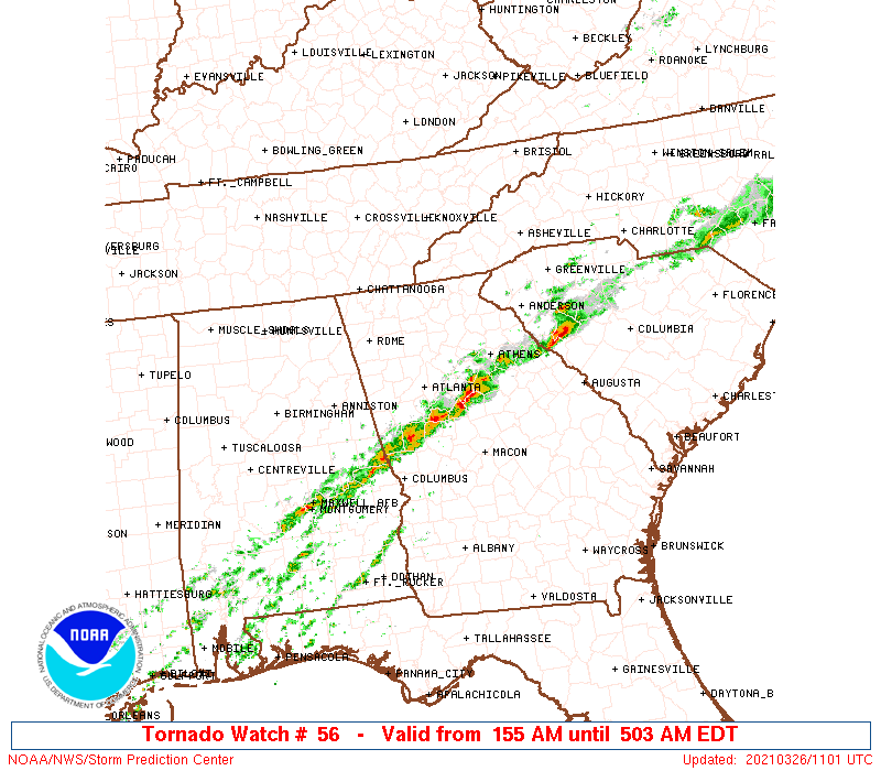
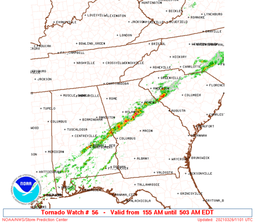
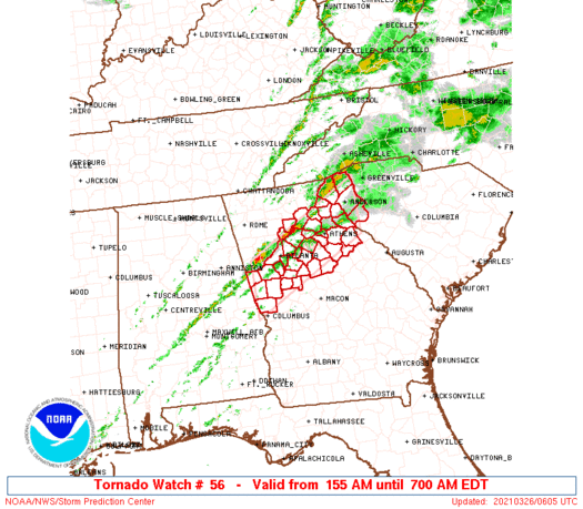
Tornado Watch Number 56
NWS Storm Prediction Center Norman OK
155 AM EDT Fri Mar 26 2021
The NWS Storm Prediction Center has issued a
* Tornado Watch for portions of
West-central and Northern Georgia
Western South Carolina
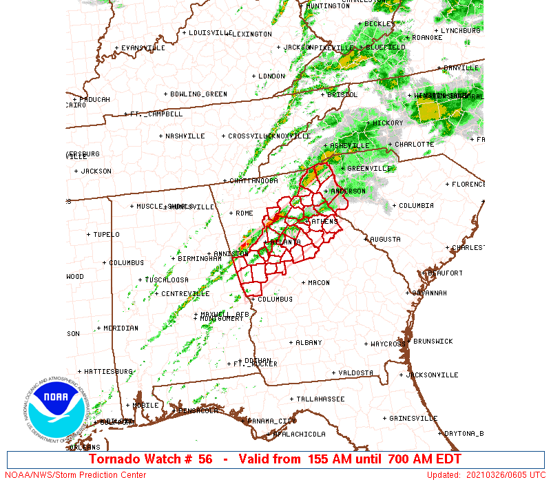
* Effective this Friday morning from 155 AM until 700 AM EDT.
* Primary threats include...
A couple tornadoes possible
Isolated damaging wind gusts to 70 mph possible
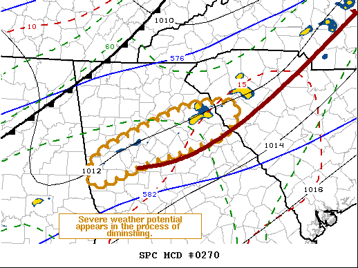
SUMMARY...While the overall severe/tornado risk has somewhat
diminished into the overnight, a residual moist and unstable air
mass coincident with very strong low-level shear could still support
isolated supercells capable of a tornado aside from isolated hail
and damaging winds through the early morning hours.
The tornado watch area is approximately along and 40 statute miles
north and south of a line from 15 miles east southeast of Anderson
SC to 5 miles northwest of La Grange GA. For a complete depiction of
the watch see the associated watch outline update (WOUS64 KWNS
WOU6).
PRECAUTIONARY/PREPAREDNESS ACTIONS...
REMEMBER...A Tornado Watch means conditions are favorable for
tornadoes and severe thunderstorms in and close to the watch
area. Persons in these areas should be on the lookout for
threatening weather conditions and listen for later statements
and possible warnings.
&&
OTHER WATCH INFORMATION...CONTINUE...WW 52...
AVIATION...Tornadoes and a few severe thunderstorms with hail
surface and aloft to 1 inch. Extreme turbulence and surface wind
gusts to 60 knots. A few cumulonimbi with maximum tops to 450. Mean
storm motion vector 23035.
...Guyer
   SEL6

   URGENT - IMMEDIATE BROADCAST REQUESTED
   Tornado Watch Number 56
   NWS Storm Prediction Center Norman OK
   155 AM EDT Fri Mar 26 2021

   The NWS Storm Prediction Center has issued a

   * Tornado Watch for portions of
     West-central and Northern Georgia
     Western South Carolina

   * Effective this Friday morning from 155 AM until 700 AM EDT.

   * Primary threats include...
     A couple tornadoes possible
     Isolated damaging wind gusts to 70 mph possible

   SUMMARY...While the overall severe/tornado risk has somewhat
   diminished into the overnight, a residual moist and unstable air
   mass coincident with very strong low-level shear could still support
   isolated supercells capable of a tornado aside from isolated hail
   and damaging winds through the early morning hours.

   The tornado watch area is approximately along and 40 statute miles
   north and south of a line from 15 miles east southeast of Anderson
   SC to 5 miles northwest of La Grange GA. For a complete depiction of
   the watch see the associated watch outline update (WOUS64 KWNS
   WOU6).

   PRECAUTIONARY/PREPAREDNESS ACTIONS...

   REMEMBER...A Tornado Watch means conditions are favorable for
   tornadoes and severe thunderstorms in and close to the watch
   area. Persons in these areas should be on the lookout for
   threatening weather conditions and listen for later statements
   and possible warnings.

   &&

   OTHER WATCH INFORMATION...CONTINUE...WW 52...

   AVIATION...Tornadoes and a few severe thunderstorms with hail
   surface and aloft to 1 inch. Extreme turbulence and surface wind
   gusts to 60 knots. A few cumulonimbi with maximum tops to 450. Mean
   storm motion vector 23035.

   ...Guyer
 Note:
The Aviation Watch (SAW) product is an approximation to the watch area.
The actual watch is depicted by the shaded areas.
Note:
The Aviation Watch (SAW) product is an approximation to the watch area.
The actual watch is depicted by the shaded areas.
   SAW6
   WW 56 TORNADO GA SC 260555Z - 261100Z
   AXIS..40 STATUTE MILES NORTH AND SOUTH OF LINE..
   15ESE AND/ANDERSON SC/ - 5NW LGC/LA GRANGE GA/
   ..AVIATION COORDS.. 35NM N/S /44ESE ODF - 4E LGC/
   HAIL SURFACE AND ALOFT..1 INCH. WIND GUSTS..60 KNOTS.
   MAX TOPS TO 450. MEAN STORM MOTION VECTOR 23035.

   LAT...LON 33848248 32478513 33638513 35008248

   THIS IS AN APPROXIMATION TO THE WATCH AREA.  FOR A
   COMPLETE DEPICTION OF THE WATCH SEE WOUS64 KWNS
   FOR WOU6.
Watch 56 Status Report Messages:
STATUS REPORT #2 ON WW 56

VALID 260830Z - 260940Z

SEVERE WEATHER THREAT CONTINUES RIGHT OF A LINE FROM 35 S AHN TO
30 SW AHN TO 25 ENE AHN TO 15 SSW AND TO 15 ESE AND.

..KERR..03/26/21

ATTN...WFO...FFC...GSP...

&&

STATUS REPORT FOR WT 56

SEVERE WEATHER THREAT CONTINUES FOR THE FOLLOWING AREAS

GAC105-133-211-219-221-265-317-260940-

GA
.    GEORGIA COUNTIES INCLUDED ARE

ELBERT		     GREENE		 MORGAN
OCONEE		     OGLETHORPE 	 TALIAFERRO
WILKES
$$


SCC001-260940-

SC
.    SOUTH CAROLINA COUNTIES INCLUDED ARE

ABBEVILLE
$$


THE WATCH STATUS MESSAGE IS FOR GUIDANCE PURPOSES ONLY.  PLEASE
REFER TO WATCH COUNTY NOTIFICATION STATEMENTS FOR OFFICIAL
INFORMATION ON COUNTIES...INDEPENDENT CITIES AND MARINE ZONES
CLEARED FROM SEVERE THUNDERSTORM AND TORNADO WATCHES.
$$

STATUS REPORT #1 ON WW 56

VALID 260735Z - 260840Z

SEVERE WEATHER THREAT CONTINUES RIGHT OF A LINE FROM 30 N LGC TO
15 WSW GSP.

..KERR..03/26/21

ATTN...WFO...FFC...GSP...

&&

STATUS REPORT FOR WT 56

SEVERE WEATHER THREAT CONTINUES FOR THE FOLLOWING AREAS

GAC013-035-059-063-077-089-105-113-119-121-133-135-145-147-149-
151-157-159-171-195-199-211-217-219-221-231-237-247-255-265-285-
297-317-260840-

GA
.    GEORGIA COUNTIES INCLUDED ARE

BARROW		     BUTTS		 CLARKE
CLAYTON 	     COWETA		 DEKALB
ELBERT		     FAYETTE		 FRANKLIN
FULTON		     GREENE		 GWINNETT
HARRIS		     HART		 HEARD
HENRY		     JACKSON		 JASPER
LAMAR		     MADISON		 MERIWETHER
MORGAN		     NEWTON		 OCONEE
OGLETHORPE	     PIKE		 PUTNAM
ROCKDALE	     SPALDING		 TALIAFERRO
TROUP		     WALTON		 WILKES
$$


SCC001-007-260840-

SC
.    SOUTH CAROLINA COUNTIES INCLUDED ARE

ABBEVILLE	     ANDERSON
$$


THE WATCH STATUS MESSAGE IS FOR GUIDANCE PURPOSES ONLY.  PLEASE
REFER TO WATCH COUNTY NOTIFICATION STATEMENTS FOR OFFICIAL
INFORMATION ON COUNTIES...INDEPENDENT CITIES AND MARINE ZONES
CLEARED FROM SEVERE THUNDERSTORM AND TORNADO WATCHES.
$$
Note:
Click for Complete Product Text.
Tornadoes
Probability of 2 or more tornadoes
|
Mod (30%)
|
Probability of 1 or more strong (EF2-EF5) tornadoes
|
Low (20%)
|
Wind
Probability of 10 or more severe wind events
|
Mod (30%)
|
Probability of 1 or more wind events > 65 knots
|
Low (10%)
|
Hail
Probability of 10 or more severe hail events
|
Low (10%)
|
Probability of 1 or more hailstones > 2 inches
|
Low (<5%)
|
Combined Severe Hail/Wind
Probability of 6 or more combined severe hail/wind events
|
Mod (50%)
|
For each watch, probabilities for particular events inside the watch
(listed above in each table) are determined by the issuing forecaster.
The "Low" category contains probability values ranging from less than 2%
to 20% (EF2-EF5 tornadoes), less than 5% to 20% (all other probabilities),
"Moderate" from 30% to 60%, and "High" from 70% to greater than 95%.
High values are bolded and lighter in color to provide awareness of
an increased threat for a particular event.


 @NWSSPC