 Note:
The expiration time in the watch graphic is amended if the watch is
replaced, cancelled or extended.
Note:
Note:
The expiration time in the watch graphic is amended if the watch is
replaced, cancelled or extended.
Note: Click for
Watch Status Reports.
SEL2
URGENT - IMMEDIATE BROADCAST REQUESTED
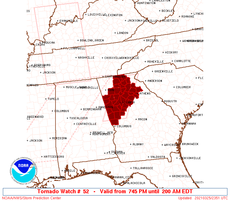
Tornado Watch Number 52
NWS Storm Prediction Center Norman OK
745 PM EDT Thu Mar 25 2021
The NWS Storm Prediction Center has issued a
* Tornado Watch for portions of
West-central and north Georgia
* Effective this Thursday night and Friday morning from 745 PM
until 200 AM EDT.
* Primary threats include...
A few tornadoes and a couple intense tornadoes possible
Isolated damaging wind gusts to 70 mph possible
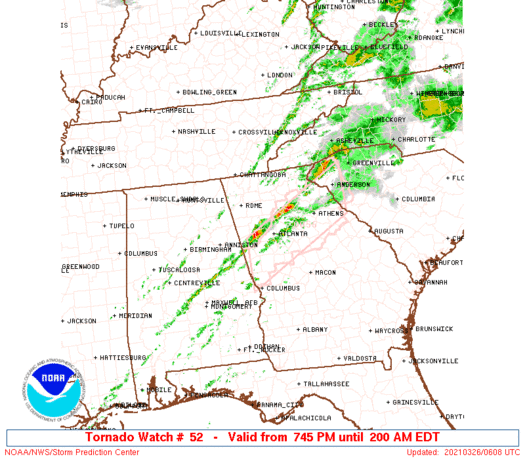
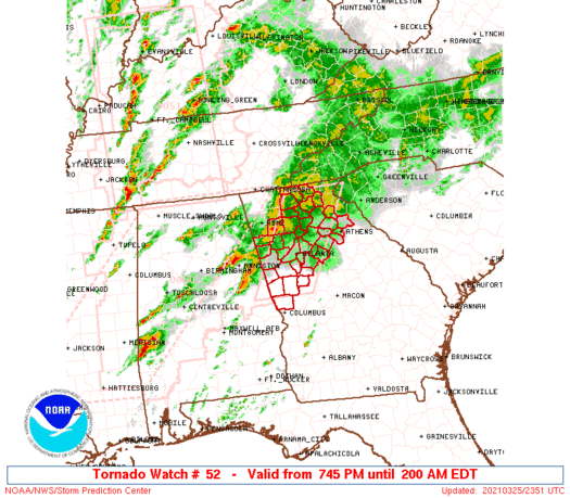
SUMMARY...Clusters with embedded supercells should progress
east-northeast from northwest Georgia and east-central Alabama.
Primary threat will be tornadoes, particularly near the surface warm
front in north Georgia and with any semi-discrete supercells
progressing into west-central Georgia.
The tornado watch area is approximately along and 40 statute miles
east and west of a line from 95 miles north northeast of Atlanta GA
to 15 miles southeast of La Grange GA. For a complete depiction of
the watch see the associated watch outline update (WOUS64 KWNS
WOU2).
PRECAUTIONARY/PREPAREDNESS ACTIONS...
REMEMBER...A Tornado Watch means conditions are favorable for
tornadoes and severe thunderstorms in and close to the watch
area. Persons in these areas should be on the lookout for
threatening weather conditions and listen for later statements
and possible warnings.
&&
OTHER WATCH INFORMATION...CONTINUE...WW 50...WW 51...
AVIATION...Tornadoes and a few severe thunderstorms with hail
surface and aloft to 1 inch. Extreme turbulence and surface wind
gusts to 60 knots. A few cumulonimbi with maximum tops to 500. Mean
storm motion vector 23040.
...Grams
   SEL2

   URGENT - IMMEDIATE BROADCAST REQUESTED
   Tornado Watch Number 52
   NWS Storm Prediction Center Norman OK
   745 PM EDT Thu Mar 25 2021

   The NWS Storm Prediction Center has issued a

   * Tornado Watch for portions of
     West-central and north Georgia

   * Effective this Thursday night and Friday morning from 745 PM
     until 200 AM EDT.

   * Primary threats include...
     A few tornadoes and a couple intense tornadoes possible
     Isolated damaging wind gusts to 70 mph possible

   SUMMARY...Clusters with embedded supercells should progress
   east-northeast from northwest Georgia and east-central Alabama.
   Primary threat will be tornadoes, particularly near the surface warm
   front in north Georgia and with any semi-discrete supercells
   progressing into west-central Georgia.

   The tornado watch area is approximately along and 40 statute miles
   east and west of a line from 95 miles north northeast of Atlanta GA
   to 15 miles southeast of La Grange GA. For a complete depiction of
   the watch see the associated watch outline update (WOUS64 KWNS
   WOU2).

   PRECAUTIONARY/PREPAREDNESS ACTIONS...

   REMEMBER...A Tornado Watch means conditions are favorable for
   tornadoes and severe thunderstorms in and close to the watch
   area. Persons in these areas should be on the lookout for
   threatening weather conditions and listen for later statements
   and possible warnings.

   &&

   OTHER WATCH INFORMATION...CONTINUE...WW 50...WW 51...

   AVIATION...Tornadoes and a few severe thunderstorms with hail
   surface and aloft to 1 inch. Extreme turbulence and surface wind
   gusts to 60 knots. A few cumulonimbi with maximum tops to 500. Mean
   storm motion vector 23040.

   ...Grams
 Note:
The Aviation Watch (SAW) product is an approximation to the watch area.
The actual watch is depicted by the shaded areas.
Note:
The Aviation Watch (SAW) product is an approximation to the watch area.
The actual watch is depicted by the shaded areas.
   SAW2
   WW 52 TORNADO GA 252345Z - 260600Z
   AXIS..40 STATUTE MILES EAST AND WEST OF LINE..
   95NNE ATL/ATLANTA GA/ - 15SE LGC/LA GRANGE GA/
   ..AVIATION COORDS.. 35NM E/W /27WNW ODF - 20SE LGC/
   HAIL SURFACE AND ALOFT..1 INCH. WIND GUSTS..60 KNOTS.
   MAX TOPS TO 500. MEAN STORM MOTION VECTOR 23040.

   LAT...LON 34908308 32848420 32848558 34908449

   THIS IS AN APPROXIMATION TO THE WATCH AREA.  FOR A
   COMPLETE DEPICTION OF THE WATCH SEE WOUS64 KWNS
   FOR WOU2.
Watch 52 Status Report Messages:
STATUS REPORT #2 ON WW 52

VALID 260540Z - 260600Z

SEVERE WEATHER THREAT CONTINUES RIGHT OF A LINE FROM 35 ESE ANB
TO 30 NNW ATL TO 65 S TYS.

PARTS OF REMAINING VALID PORTION OF WW WILL EITHER BE LOCALLY
EXTENDED IN TIME/AREA, OR A NEW WW WILL BE ISSUED.

..KERR..03/26/21

ATTN...WFO...FFC...

&&

STATUS REPORT FOR WT 52

SEVERE WEATHER THREAT CONTINUES FOR THE FOLLOWING AREAS

GAC011-013-059-063-077-089-113-117-121-135-139-145-149-151-157-
187-195-199-217-219-231-247-255-285-297-311-260600-

GA
.    GEORGIA COUNTIES INCLUDED ARE

BANKS		     BARROW		 CLARKE
CLAYTON 	     COWETA		 DEKALB
FAYETTE 	     FORSYTH		 FULTON
GWINNETT	     HALL		 HARRIS
HEARD		     HENRY		 JACKSON
LUMPKIN 	     MADISON		 MERIWETHER
NEWTON		     OCONEE		 PIKE
ROCKDALE	     SPALDING		 TROUP
WALTON		     WHITE
$$


THE WATCH STATUS MESSAGE IS FOR GUIDANCE PURPOSES ONLY.  PLEASE
REFER TO WATCH COUNTY NOTIFICATION STATEMENTS FOR OFFICIAL
INFORMATION ON COUNTIES...INDEPENDENT CITIES AND MARINE ZONES
CLEARED FROM SEVERE THUNDERSTORM AND TORNADO WATCHES.
$$

STATUS REPORT #1 ON WW 52

VALID 260220Z - 260400Z

THE SEVERE WEATHER THREAT CONTINUES ACROSS THE ENTIRE WATCH AREA.

..SMITH..03/26/21

ATTN...WFO...FFC...

&&

STATUS REPORT FOR WT 52

SEVERE WEATHER THREAT CONTINUES FOR THE FOLLOWING AREAS

GAC011-013-015-045-057-059-063-067-077-085-089-097-111-113-117-
121-123-135-139-143-145-149-151-157-187-195-199-217-219-223-227-
231-233-247-255-285-291-297-311-260400-

GA
.    GEORGIA COUNTIES INCLUDED ARE

BANKS		     BARROW		 BARTOW
CARROLL 	     CHEROKEE		 CLARKE
CLAYTON 	     COBB		 COWETA
DAWSON		     DEKALB		 DOUGLAS
FANNIN		     FAYETTE		 FORSYTH
FULTON		     GILMER		 GWINNETT
HALL		     HARALSON		 HARRIS
HEARD		     HENRY		 JACKSON
LUMPKIN 	     MADISON		 MERIWETHER
NEWTON		     OCONEE		 PAULDING
PICKENS 	     PIKE		 POLK
ROCKDALE	     SPALDING		 TROUP
UNION		     WALTON		 WHITE
$$


THE WATCH STATUS MESSAGE IS FOR GUIDANCE PURPOSES ONLY.  PLEASE
REFER TO WATCH COUNTY NOTIFICATION STATEMENTS FOR OFFICIAL
INFORMATION ON COUNTIES...INDEPENDENT CITIES AND MARINE ZONES
CLEARED FROM SEVERE THUNDERSTORM AND TORNADO WATCHES.
$$
Note:
Click for Complete Product Text.
Tornadoes
Probability of 2 or more tornadoes
|
Mod (50%)
|
Probability of 1 or more strong (EF2-EF5) tornadoes
|
Mod (30%)
|
Wind
Probability of 10 or more severe wind events
|
Mod (30%)
|
Probability of 1 or more wind events > 65 knots
|
Low (10%)
|
Hail
Probability of 10 or more severe hail events
|
Low (10%)
|
Probability of 1 or more hailstones > 2 inches
|
Low (10%)
|
Combined Severe Hail/Wind
Probability of 6 or more combined severe hail/wind events
|
Mod (50%)
|
For each watch, probabilities for particular events inside the watch
(listed above in each table) are determined by the issuing forecaster.
The "Low" category contains probability values ranging from less than 2%
to 20% (EF2-EF5 tornadoes), less than 5% to 20% (all other probabilities),
"Moderate" from 30% to 60%, and "High" from 70% to greater than 95%.
High values are bolded and lighter in color to provide awareness of
an increased threat for a particular event.


 @NWSSPC