 Note:
The expiration time in the watch graphic is amended if the watch is
replaced, cancelled or extended.
Note:
Note:
The expiration time in the watch graphic is amended if the watch is
replaced, cancelled or extended.
Note: Click for
Watch Status Reports.
SEL7
URGENT - IMMEDIATE BROADCAST REQUESTED
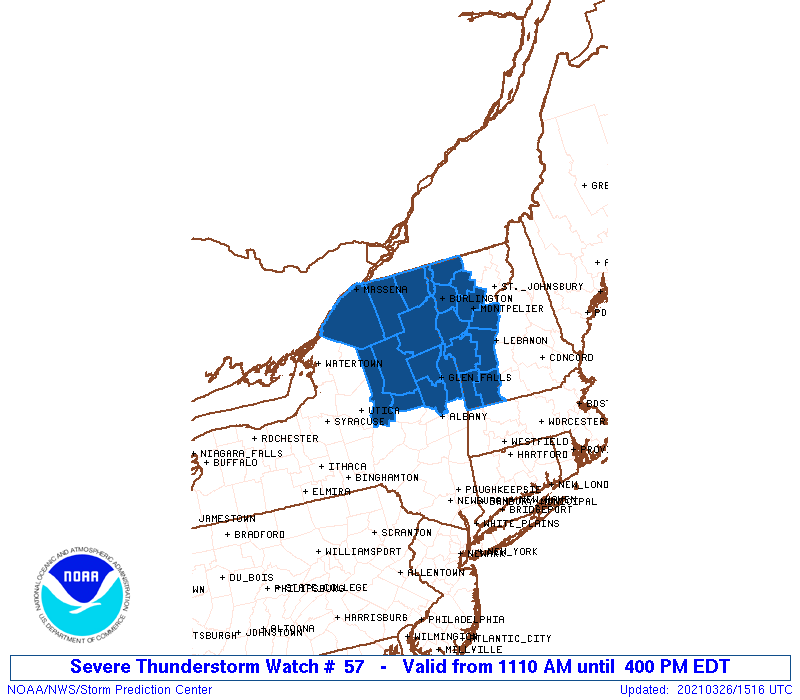
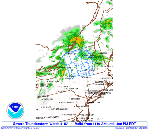
Severe Thunderstorm Watch Number 57
NWS Storm Prediction Center Norman OK
1110 AM EDT Fri Mar 26 2021
The NWS Storm Prediction Center has issued a
* Severe Thunderstorm Watch for portions of
Upstate New York
Much of Vermont
* Effective this Friday morning and afternoon from 1110 AM until
400 PM EDT.
* Primary threats include...
Scattered damaging wind gusts to 70 mph possible
SUMMARY...Short bands of fast-moving thunderstorms are expected to
move across upstate New York and into Vermont through the afternoon,
with the potential to produce damaging winds.
The severe thunderstorm watch area is approximately along and 65
statute miles east and west of a line from 40 miles north northeast
of Saranac Lake NY to 20 miles south southwest of Glens Falls NY.
For a complete depiction of the watch see the associated watch
outline update (WOUS64 KWNS WOU7).
PRECAUTIONARY/PREPAREDNESS ACTIONS...
REMEMBER...A Severe Thunderstorm Watch means conditions are
favorable for severe thunderstorms in and close to the watch area.
Persons in these areas should be on the lookout for threatening
weather conditions and listen for later statements and possible
warnings. Severe thunderstorms can and occasionally do produce
tornadoes.
&&
AVIATION...A few severe thunderstorms with hail surface and aloft to
0.5 inches. Extreme turbulence and surface wind gusts to 60 knots. A
few cumulonimbi with maximum tops to 400. Mean storm motion vector
25045.
...Thompson
   SEL7

   URGENT - IMMEDIATE BROADCAST REQUESTED
   Severe Thunderstorm Watch Number 57
   NWS Storm Prediction Center Norman OK
   1110 AM EDT Fri Mar 26 2021

   The NWS Storm Prediction Center has issued a

   * Severe Thunderstorm Watch for portions of
     Upstate New York
     Much of Vermont

   * Effective this Friday morning and afternoon from 1110 AM until
     400 PM EDT.

   * Primary threats include...
     Scattered damaging wind gusts to 70 mph possible

   SUMMARY...Short bands of fast-moving thunderstorms are expected to
   move across upstate New York and into Vermont through the afternoon,
   with the potential to produce damaging winds.

   The severe thunderstorm watch area is approximately along and 65
   statute miles east and west of a line from 40 miles north northeast
   of Saranac Lake NY to 20 miles south southwest of Glens Falls NY.
   For a complete depiction of the watch see the associated watch
   outline update (WOUS64 KWNS WOU7).

   PRECAUTIONARY/PREPAREDNESS ACTIONS...

   REMEMBER...A Severe Thunderstorm Watch means conditions are
   favorable for severe thunderstorms in and close to the watch area.
   Persons in these areas should be on the lookout for threatening
   weather conditions and listen for later statements and possible
   warnings. Severe thunderstorms can and occasionally do produce
   tornadoes.

   &&

   AVIATION...A few severe thunderstorms with hail surface and aloft to
   0.5 inches. Extreme turbulence and surface wind gusts to 60 knots. A
   few cumulonimbi with maximum tops to 400. Mean storm motion vector
   25045.

   ...Thompson
 Note:
The Aviation Watch (SAW) product is an approximation to the watch area.
The actual watch is depicted by the shaded areas.
Note:
The Aviation Watch (SAW) product is an approximation to the watch area.
The actual watch is depicted by the shaded areas.
SAW7
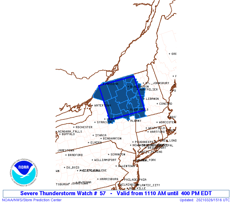
WW 57 SEVERE TSTM NY VT 261510Z - 262000Z
AXIS..65 STATUTE MILES EAST AND WEST OF LINE..
40NNE SLK/SARANAC LAKE NY/ - 20SSW GFL/GLENS FALLS NY/
..AVIATION COORDS.. 55NM E/W /21NW PLB - 19N ALB/
HAIL SURFACE AND ALOFT..0.5 INCH. WIND GUSTS..60 KNOTS.
MAX TOPS TO 400. MEAN STORM MOTION VECTOR 25045.
LAT...LON 44917256 43067248 43067506 44917522
THIS IS AN APPROXIMATION TO THE WATCH AREA. FOR A
COMPLETE DEPICTION OF THE WATCH SEE WOUS64 KWNS
FOR WOU7.
Watch 57 Status Report Messages:
STATUS REPORT #3 ON WW 57

VALID 261840Z - 261940Z

SEVERE WEATHER THREAT CONTINUES RIGHT OF A LINE FROM 20 NNW ALB
TO 25 NNW RUT TO 15 ENE BTV TO 30 WNW EFK.

..JEWELL..03/26/21

ATTN...WFO...BTV...ALY...

&&

STATUS REPORT FOR WS 57

SEVERE WEATHER THREAT CONTINUES FOR THE FOLLOWING AREAS

NYC091-115-261940-

NY
.    NEW YORK COUNTIES INCLUDED ARE

SARATOGA	     WASHINGTON
$$


VTC001-003-007-011-015-017-021-023-025-027-261940-

VT
.    VERMONT COUNTIES INCLUDED ARE

ADDISON 	     BENNINGTON 	 CHITTENDEN
FRANKLIN	     LAMOILLE		 ORANGE
RUTLAND 	     WASHINGTON 	 WINDHAM
WINDSOR
$$


THE WATCH STATUS MESSAGE IS FOR GUIDANCE PURPOSES ONLY.  PLEASE
REFER TO WATCH COUNTY NOTIFICATION STATEMENTS FOR OFFICIAL
INFORMATION ON COUNTIES...INDEPENDENT CITIES AND MARINE ZONES
CLEARED FROM SEVERE THUNDERSTORM AND TORNADO WATCHES.
$$

STATUS REPORT #2 ON WW 57

VALID 261720Z - 261840Z

SEVERE WEATHER THREAT CONTINUES RIGHT OF A LINE FROM 15 ESE UCA
TO 45 ENE UCA TO 30 NW GFL TO 30 NNW GFL TO 40 N GFL TO 35 ESE
SLK TO 25 W BTV TO 25 NE SLK TO 40 ENE MSS.

..JEWELL..03/26/21

ATTN...WFO...BTV...ALY...

&&

STATUS REPORT FOR WS 57

SEVERE WEATHER THREAT CONTINUES FOR THE FOLLOWING AREAS

NYC019-031-035-041-091-113-115-261840-

NY
.    NEW YORK COUNTIES INCLUDED ARE

CLINTON 	     ESSEX		 FULTON
HAMILTON	     SARATOGA		 WARREN
WASHINGTON
$$


VTC001-003-007-011-013-015-017-021-023-025-027-261840-

VT
.    VERMONT COUNTIES INCLUDED ARE

ADDISON 	     BENNINGTON 	 CHITTENDEN
FRANKLIN	     GRAND ISLE 	 LAMOILLE
ORANGE		     RUTLAND		 WASHINGTON
WINDHAM 	     WINDSOR
$$


THE WATCH STATUS MESSAGE IS FOR GUIDANCE PURPOSES ONLY.  PLEASE
REFER TO WATCH COUNTY NOTIFICATION STATEMENTS FOR OFFICIAL
INFORMATION ON COUNTIES...INDEPENDENT CITIES AND MARINE ZONES
CLEARED FROM SEVERE THUNDERSTORM AND TORNADO WATCHES.
$$

STATUS REPORT #1 ON WW 57

VALID 261630Z - 261740Z

SEVERE WEATHER THREAT CONTINUES RIGHT OF A LINE FROM 15 NNE UCA
TO 35 NE UCA TO 50 NE UCA TO 40 SSW SLK TO 30 SSW SLK TO 30 SW
SLK TO 30 W SLK TO 20 NE MSS.

..JEWELL..03/26/21

ATTN...WFO...BTV...ALY...

&&

STATUS REPORT FOR WS 57

SEVERE WEATHER THREAT CONTINUES FOR THE FOLLOWING AREAS

NYC019-031-033-035-041-043-091-113-115-261740-

NY
.    NEW YORK COUNTIES INCLUDED ARE

CLINTON 	     ESSEX		 FRANKLIN
FULTON		     HAMILTON		 HERKIMER
SARATOGA	     WARREN		 WASHINGTON
$$


VTC001-003-007-011-013-015-017-021-023-025-027-261740-

VT
.    VERMONT COUNTIES INCLUDED ARE

ADDISON 	     BENNINGTON 	 CHITTENDEN
FRANKLIN	     GRAND ISLE 	 LAMOILLE
ORANGE		     RUTLAND		 WASHINGTON
WINDHAM 	     WINDSOR
$$


THE WATCH STATUS MESSAGE IS FOR GUIDANCE PURPOSES ONLY.  PLEASE
REFER TO WATCH COUNTY NOTIFICATION STATEMENTS FOR OFFICIAL
INFORMATION ON COUNTIES...INDEPENDENT CITIES AND MARINE ZONES
CLEARED FROM SEVERE THUNDERSTORM AND TORNADO WATCHES.
$$
Note:
Click for Complete Product Text.
Tornadoes
Probability of 2 or more tornadoes
|
Low (10%)
|
Probability of 1 or more strong (EF2-EF5) tornadoes
|
Low (5%)
|
Wind
Probability of 10 or more severe wind events
|
Mod (40%)
|
Probability of 1 or more wind events > 65 knots
|
Low (20%)
|
Hail
Probability of 10 or more severe hail events
|
Low (10%)
|
Probability of 1 or more hailstones > 2 inches
|
Low (<5%)
|
Combined Severe Hail/Wind
Probability of 6 or more combined severe hail/wind events
|
Mod (60%)
|
For each watch, probabilities for particular events inside the watch
(listed above in each table) are determined by the issuing forecaster.
The "Low" category contains probability values ranging from less than 2%
to 20% (EF2-EF5 tornadoes), less than 5% to 20% (all other probabilities),
"Moderate" from 30% to 60%, and "High" from 70% to greater than 95%.
High values are bolded and lighter in color to provide awareness of
an increased threat for a particular event.


 @NWSSPC